
Where Flight Simulation Enthusiasts Gather from Around the World!
AVSIM Library - Search Results

| Category: Flight Simulator 2004 - Scenery | |
| Paulatuk CYPC in the Northwest Territories, Canada |

|
Images related to this file:
File Description:
Paulatuk is on the coast of northern mainland Canada, 200 miles east of Tuktoyaktuk and 170 miles southwest of Ulukhaktok. It is just to the east of the Parry Peninsula, which has at its northern tip the Cape Parry DEW line Main Station. Paulatuk was established in the 1920's, and the population now numbers around 320. Paulatuk airfield is close to the village but on higher ground, while the village follows the curve of the coast. The 4,000 feet of 100 feet wide gravel runway is aligned 021T/201T where T stands for "true" as opposed to magnetic in the Northern Domestic Airspace. Only JETA-1 is available unless there is 100LL in drums. There are flights by Aklak Air from Inuvik, which is around 250 miles to the west; Aklak Air is actually Kenn Borek under a diferent name. The AI is for a daily passenger flight, and for a cargo flight on Wednesdays. In the summer, float planes use the lake to the south of the village, but I have no information as to docks or any other facilities; probably there aren't any.
| Filename: | Paulatuk_CYPC_in_the_Northwest_Territories_Canada.zip |
| License: | Freeware, limited distribution |
| Added: | 3rd December 2012, 21:58:47 |
| Downloads: | 277 |
| Author: | Roger Wensley |
| Size: | 4.39 MB |
| Category: Flight Simulator 2004 - Scenery | |
| Carp CYRP in Ontario Canada (updated October 2011) |
|
Images related to this file:
File Description:
This version further updates the post of 2006 and the 2009 update with more bespoke buildings for the west GA apron plus the revised fuelling area, and corrected surroundings with large forested areas and a modified airfield grass shape. This is a stand-alone version and does not require you to have downloaded and installed the previous posts; this REPLACES those versions. Carp airfield is fifteen miles west of Ottawa and two miles south of the town of Carp. There are two runways, 10/28 which is asphalt and almost 4,000 feet long and 100 feet wide, and 04/22 which is gravel and 2,000 feet long. The airfield has a fairly large population of general aviation residents and is slowly expanding under new ownership. This version models the large hangar beside the terminal, the "Touch'n Go" aviation warehouse that has opened more recently, and the ramshackle collection of hangars and sheds that make up Westair, the maintenance facility. The nearby pagoda-roof flight school building has in fact now been demolished, but I like it too much to do that, at least until something else has been built on that space.
| Filename: | Carp_CYRP_in_Ontario_Canada__updated_October_2011.zip |
| License: | Freeware, limited distribution |
| Added: | 25th November 2011, 09:25:34 |
| Downloads: | 587 |
| Author: | Roger Wensley |
| Size: | 7.59 MB |
| Category: Flight Simulator 2004 - Scenery | |
| Boundary Bay CZBB in British Columbia, Canada |
|
Images related to this file:
File Description:
Boundary Bay is south of Vancouver in British Columbia, close to the US/Canada border. It is the 5th busiest airfield in Canada measured in terms of take offs and landings as there are several training companies based there. The airfield was purchased by Alpha Aviation in 2009 and and modernised for the 2010 Winter Olympics, the main addition being a new terminal. This is an ex-military training base which was built in 1941, and one of the original hangars still survives. The two runways in use now (07/25 5,600' and 12/30 2,750', both of them 100' wide) are reduced asphalted areas of the original runways; the third runway is now an apron for GA parking and has had hangars built along it. There is JetA and 100LL available. The large building at the east end of the north apron is a HQ and maintenance facility for a helicopter company, Heli-one. All of the north apron buildings on the field have been modelled specifically for this scenery, plus the nearby huge greenhouse farm structures which are visible from further away than the airfield is. AI for Boundary Bay will be posted later this week.
| Filename: | Boundary_Bay_CZBB_in_British_Columbia_Canada.zip |
| License: | Freeware, limited distribution |
| Added: | 12th May 2011, 13:30:18 |
| Downloads: | 854 |
| Author: | Roger Wensley |
| Size: | 4.4 MB |
| Category: Flight Simulator 2004 - Scenery | |
| ISD Milan (Bergamo) Orio al Serio - Update 2013 |
|
Images related to this file:
File Description:

Cari Amici Simmer Dear friends and lovers of the eternal FS2004, thanks to the work carried out by the Bgl Mr. Gianluca Giovannini, the tower by luca Manineti, airport objects of Mr. Andrei Visan, the upgrades from the ISD project, and the new frequency vor Fabio Iaria and the grass in 3d by MrKobbe Farwick. I tried an update of the Milan-Bergamo "Orio al Serio", the undisputed leader of the panorama Low fare in Italy. The scenery is not a new job, but an adaptation and updating of files scanrio isd 2002. In the new work will, therefore, the new tower of the city near the airport, the outline of trees along the surface of the airport, new airport objects, 3D grass, industrial buildings on the highway, night lights and a new reconstruction of the new terminal. I also realizizzato an urban area to recreate the city of Bergamo Orio al Serio and Bergmao and Alta. Compatible with AES latest version.
not assume responsibility for any errors that may occur, for information [email protected] "Fafo's air production."
A greeting and good flights - Fabio Ferrari, Castione della Presolana (BG) Italy.
Long life fs 2004! And Best regards from Italy
| Filename: | ISD_Milan_Bergamo_Orio_al_Serio__Update_2013.zip |
| License: | Freeware, limited distribution |
| Added: | 24th January 2013, 03:06:34 |
| Downloads: | 4,953 |
| Author: | Fabio Ferrari, Gianluca Giovannini, Luca Mainenti |
| Size: | 103.44 MB |
| Category: Flight Simulator 2004 - Scenery | |
| Inyokern Airport, Inyokern CA. , USA - Version 3 |
|
Images related to this file:
File Description:
FS2004 Scenery for Inyokern Airport (KIYK). SORRY everyone there were some libraries and textures missing from the recent release. This package contains all missing objects and libraries and is a complete replacement for ANY of my Inyokern sceneries previously installed, no other download required. (Nestled on the sunny side of the southern Sierras, Inyokern is a great jumping-off place for hi desert adventures. Known for decades for it's great soaring spots, Inyokern itself is busy enough with an average of 80 flights a day including it's United/Skywest commuter flights and occasional military traffic from the nearby China Lake Naval Weapons Test Center. Geographically, the airport is situated in the high desert of Southern California, 100 miles east-northeast of the county seat in Bakersfield, 80 miles north-northeast of the Lancaster and Palmdale areas, and 120 miles north-northwest of San Bernardino. The airport itself covers 1,640 acres at an elevation of 2,457 feet, with three asphalt paved runways that can accommodate almost any class of civilian, commercial, or military aircraft. Inyokern Airport is served by commercial airlines connecting through Los Angeles International Airport.)
| Filename: | Inyokern_Airport_Inyokern_CA__USA__Version_3.zip |
| License: | Freeware, limited distribution |
| Added: | 10th November 2013, 23:32:02 |
| Downloads: | 2,056 |
| Author: | John Stinstrom |
| Size: | 6.36 MB |
| Category: Flight Simulator 2004 - Scenery | |
| CYEN Estevan Saskatchewan Municipal Airport |
|
Images related to this file:
File Description:

CYEN Estevan Municipal airport is situated approximately three miles (6 Km) north of the City of Estevan. CYEN Estevan Muni was constructed using GMAX and represents the airport as it was in the Summer of 2006. It includes all the buildings at the airport, runway signs, addition of some fencing, anda new rotating beacon that is closer to the actual device. CYEN also includes a landclass file to better represent the terrain around the airport, at least as far as the limits of the default landscape will allow.
The airport is home to Sunrise Aviation (which operates the field for the city) and some 26 light aircraft. CYEN handles a wide variety of Canadian and U.S. corporate and charter aircraft given the large oil and coal mining industry in the area. With the U.S. border so close by, CYEN is also the first stop for many U.S. registered aircraft that land to clear customs and refuel.
(This is a re-upload of the scenery to replace the original that was lost in the AVSIM hack. No changes have been made)
| Filename: | CYEN_Estevan_Saskatchewan_Municipal_Airport.zip |
| License: | Freeware |
| Added: | 7th May 2010, 12:47:13 |
| Downloads: | 1,701 |
| Author: | Gregory Putz |
| Size: | 1.67 MB |
| Category: Flight Simulator 2004 - Scenery | |
| Alaska South Slope 2 - Noorvik ORV in AK US |
|
Images related to this file:
File Description:
The town of Kotzebue is in the far northwest of Alaska, and these are villages to the north and the east of Kotzebue on the South Slope of the Brooks Range of mountains. There will be further additions. Noorvik is a small village (population now around 670) on the bank of the Kobuk River, around 50 miles east of Kotzebue. The new airfield is 1 mile south of the village; there is a short runway immediately south of the town that is now closed but is not marked as such and appears to be usable; this will still be listed in FS9 when you are presented with a choice of runways but is not connected in any way to the new airfield so ignore it. The new ORV runway has 4,000 feet of lit gravel aligned 06-24. There are scheduled flights by Era (now renamed Ravn) and by Bering Air, both of them originating in Kotzebue and routing east to Noorvik, Kiana, Ambler, Shungnak, Kobuk, and then back again. The AI includes these flights (eventually) plus perhaps an Everts Air cargo flight and GA.
| Filename: | Alaska_South_Slope_2__Noorvik_ORV_in_AK_US.zip |
| License: | Freeware, limited distribution |
| Added: | 4th September 2016, 18:20:02 |
| Downloads: | 220 |
| Author: | Roger Wensley |
| Size: | 3.95 MB |
| Category: Flight Simulator 2004 - Scenery | |
| Hal Far Float Base, Malta |
|
File Description:
Hal Far Float Base is a large facility located just to the Southeast of Hal Far Royal Naval Air Station, Malta, circa WWII. The base is entirely ficticious. Aerosoft's "Islands of Malta" is required for this scenery to work. Default scenery places this floatbase entirely on land. See also O. Morris' "hal_far_v2.zip"
| Filename: | Hal_Far_Float_Base_Malta.zip |
| License: | Freeware, limited distribution |
| Added: | 25th April 2012, 02:38:53 |
| Downloads: | 170 |
| Author: | Stew Stewart |
| Size: | 9.86 MB |
| Category: Flight Simulator 2004 - Scenery | |
| Vieux-Ferette ULM (LF6822) |
|
File Description:
FS2004/FS2002 scenery. Vieux-Ferette LF6822.
This package contain the Vieux-Ferette ULM airfield.
A small but very great ULM field located in ALsace,
Northeast from France. Included Hangars, Club House,
static ULMs and much more... Very great start point
to fly in VFR and discover the region with your
favorite ULM.
| Filename: | VieuxFerette_ULM_LF6822.zip |
| License: | Freeware |
| Added: | 28th October 2003, 15:43:41 |
| Downloads: | 3,218 |
| Author: | Hauger Fredo |
| Size: | 2.17 MB |
| Category: Flight Simulator 2004 - Scenery | |
| Downtown Buildings - Albany, New York, USA |
|
Images related to this file:
File Description:
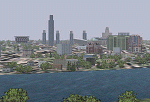
A skyline re-make of the Albany, New York, USA - Downtown area, properly representing the actual Albany skyline.
Photoreal textures for all buildings remade, including night textures. Obviously, SOME liberty taken with building design for lack of actual specs and framerates. Downtown area landclass file included. By Ed "Geneer" Cox
| Filename: | Downtown_Buildings__Albany_New_York_USA.zip |
| License: | Freeware, limited distribution |
| Added: | 14th May 2010, 09:38:23 |
| Downloads: | 2,877 |
| Author: | EdGeneer Cox |
| Size: | 990.88 KB |
© 2001-2026 AVSIM Online
All Rights Reserved
Privacy Policy |