
Where Flight Simulation Enthusiasts Gather from Around the World!
AVSIM Library - Search Results

| Category: Flight Simulator 2004 - Scenery | |
| Kimmirut CYLC on Baffin Island in Nunavut, Canada |

|
Images related to this file:
File Description:
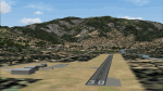
Kimmirut is a village of some 400 folks at the southern end of the southwest-facing coast of Baffin Island, 75 miles southwest of Iqaluit. It is on the northern side of the Hudson Strait between Baffin Island and Quebec, opposite Kangiqsujuaq on the Quebec shore. The airfield is served by two flights per week, one on Monday and another on Friday, only half fueled to be able to use the 1,899' of gravel 75' wide runway. The terminal building is small and there is a garage building for airport maintenance vehicles (snow clearing). There are some nearby buildings that I have included. The village is "represented" (not "modeled") with approximately the right shape and road layout. Take enough fuel so that you can leave again, as fuel is no longer for sale here. The Cape Dyer bgls are to make a small correction, it is explained in the text. I will not be posting new sceneries in the future and this is the last one for Avsim; it completes Baffin Island.
| Filename: | Kimmirut_CYLC_on_Baffin_Island_in_Nunavut_Canada.zip |
| License: | Freeware, limited distribution |
| Added: | 25th July 2011, 17:36:57 |
| Downloads: | 534 |
| Author: | Roger Wensley |
| Size: | 2.53 MB |
| Category: Flight Simulator 2004 - Scenery | |
| Clinton Point CWCP, Horton River CWHR & Keats Point CWKP; DEW sites in Northwest Territories, Canada |
|
Images related to this file:
File Description:
These are three DEW line sites in northern mainland Canada, to the east of Tuktoyaktuk.
Clinton Point is almost 300 miles east of Tuktoyaktuk and on the Northwest Territories and Nunavut border. It is the site of a closed DEW station (closed in 1993) and all the buildings have been removed, unlike many other sites where buildings are still almost complete. The roads and the gravel runway down by the beach are still there.
Horton River is 150 miles east of Tuktoyaktuk, up on higher land above the cliffs at around 500 feet ASL. The NWS (North Warning System) replaced the I site which was there previously and which ceased operations in 1963. The NWS is serviced by helicopter from a barge 400 yards away on the beach.
Keats Point is 270 miles east of Tuktoyaktuk, 7 miles from the coast but significantly close to a lake, which was probably used for float plane delivery in the summer (or ski plane delivery in the winter) of NWS station elements during construction.
| Filename: | Clinton_Point_CWCP_Horton_River_CWHR__Keats_Point_.zip |
| License: | Freeware, limited distribution |
| Added: | 17th July 2012, 18:57:08 |
| Downloads: | 279 |
| Author: | Roger Wensley |
| Size: | 2.07 MB |
| Category: Flight Simulator 2004 - Scenery | |
| YEVD Evans Head Memorial, Australia |
|
File Description:
Googly scenery for YEVD Evans Head Memorial, a former RAAF Training base in
New South Wales, Australia, now reduced to a single runway and small apron.
In its heyday it was home to the RAAF No 1 Bombing and Gunnery and the RAAF No 1
Air Observers Schools and it was said to be the largest training base in the
southern hemisphere - at that time it had four runways.
Flight Simulator 2004 has made no provision for traffic with only a runway
provided and this scenery seeks to redress the situation so that you and your
"AI" traffic can use the airport.
The scenery does not purport to be ultra-accurate. Based on high quality
satellite imagery from Google Earth, the layout is proportionally correct but the
added airport features, such as buildings, are built from default Microsoft objects
and add-on libraries so will not look exactly like the real thing.
You are not obliged to download and install any additional scenery libraries,
but to enjoy this scenery in its entirety, you may wish to. It will work fine,
with or without.
| Filename: | YEVD_Evans_Head_Memorial_Australia.zip |
| License: | Freeware |
| Added: | 19th April 2008, 10:23:02 |
| Downloads: | 544 |
| Author: | John Hinson |
| Size: | 71.78 KB |
| Category: Flight Simulator 2004 - Scenery | |
| Sigonella AB - Sicily, Italy |
|
Images related to this file:
File Description:

Naval Air Station Sigonella, "The Hub of the Med", is a U.S. Navy installation at NATO Base Sigonella and an Italian Air Force base in Sicily, Italy. Although a tenant of the Italian Air Force, NAS Sigonella acts as landlord to more than 40 other U.S. commands and activities. It is located 15 km west and 11 km south of the city of Catania. Sigonella also serves as an Italian base for the 41º Stormo Antisom (41st Antisubmarine Warfare Wing). Among the aircraft that fly from this island base are U.S. Air Force C-130, C-17 and C-5 airlifters as well as KC refueling aircraft and a rotating squadron of forward-deployed U.S. Navy P-3 Orions. The Italian Air Force also fields the venerable Breguet Atlantic patrol aircraft. It is one of the most frequently used stops for U.S. airlift aircraft bound from the continental United States to Southwest Asia and the Indian Ocean. Scenery contains all new 3D models and AI aircraft. Package is stand-alone but additional downloads may be helpful (see docs for details).
| Filename: | Sigonella_AB__Sicily_Italy.zip |
| License: | Freeware, limited distribution |
| Added: | 3rd June 2014, 06:25:24 |
| Downloads: | 2,099 |
| Author: | John Stinstrom |
| Size: | 4 MB |
| Category: Flight Simulator 2004 - Scenery | |
| CYYN Swift Current Municipal Airport |
|
File Description:
Swift Current Municipal airport is situated approximately 8 km east of the City of Swift Current. It is one of those tiny airports where the default flightsim scenery has no resemblance to the real world airport. CYYN was constructed using GMAX and represents the airport as it was in the Summer of 2007. It includes nearly all the buildings at the airport, runway signs, the addition of fencing, and a rotating beacon. CYYN also includes a landclass file to better represent the terrain around the airport, at least as far as the limits of the default landscape will allow. The airport has a long history, being built in 1937, as one of the hundred-mile airports on the Trans Canada airway. It was greatly expanded as an RCAF / RAF station during world war II. Many of the wartime structures still exist but many are in poor shape. Two of the original three runways remain in service. The airfield is often used by 15 Wing aircraft of CFB Moose Jaw to practice approaches.
| Filename: | CYYN_Swift_Current_Municipal_Airport.zip |
| License: | Freeware |
| Added: | 30th August 2008, 03:25:36 |
| Downloads: | 1,342 |
| Author: | Gregory Putz |
| Size: | 5.28 MB |
| Category: Flight Simulator 2004 - Scenery | |
| Kona at Keahole International Airport PHKO |
|
File Description:
This is a completely new Kona, which is now more correctly laid out and very detailed. This is one of the most unique and beautiful airports in the world. It resembles a Hawaiian Village and Botanic garden combined, and is completey open air. The airport is built on old lava flows, and the terminal area is full of lava rock walls, which was probably mined while constructing the taxiways, tarmacs, and terminal itself. This scenery redoes the entire airport, and includes details like baggage carrousels, benches at the gate areas, check-in counters, parking lot shelters, and some purple baggage carts to go with the Island atmosphere. Since this airport has no jetways, I have created some new lower impact air stairs, and have positioned them around the two main gate areas. There is also a large air stair at each gate area to accommodate heavy jetliners. The unique ramp lights found at this airport are also included as well as some interesting night lit ramp textures. It has not been tested in FS2002.
| Filename: | Kona_at_Keahole_International_Airport______PHKO.zip |
| License: | Freeware |
| Added: | 16th January 2004, 14:14:35 |
| Downloads: | 6,780 |
| Author: | Bill Melichar |
| Size: | 5.52 MB |
| Category: Flight Simulator 2004 - Scenery | |
| Airstrips of Eastern France |
|
Images related to this file:
File Description:
Next in my ongoing "Airstrips of Western Europe" project for FS2004, herewith about 100 sceneries of small, mostly default airfields in the eastern section of France, each enhanced with taxiways, parking spaces and aprons as appropriate, to further facilitate the generation of lightweight AI traffic in the area without overloading the more major airfields. When combined with the French airstrips from my previous uploads, the majority of the default small French airstrips in FS2004 will be able to generate AI traffic, should you so wish, as well as putting a little basic detail into the countryside.
Again, there's no photo-realism here, just a selection of basic 'generic' buildings, more or less accurately sized and placed to reflect the airfield layout as seen on on-line satellite imagery and aerial photography. These buildings have minimal effect on frame-rates, so are ideal for this kind of job. The airfields are aligned as well as possible with the roads etc. in UT Europe and the Genesis Europe mesh, but should mostly be fine in a default installation or other configuration.
| Filename: | Airstrips_of_Eastern_France.zip |
| License: | Freeware |
| Added: | 25th September 2024, 13:37:50 |
| Downloads: | 149 |
| Author: | Chris Eve |
| Size: | 2.83 MB |
| Category: Flight Simulator 2004 - Scenery | |
| McKenzie Airfield, Richmond, South Africa |
|
Images related to this file:
File Description:
Have you ever visited the "Hangar Cafe"? Great place to have a meal and get lost in conversation with fellow aviators and aviation lovers.
McKenzie Airfield does not appear in the default FS2004, neither is the town of Richmond included. This package will add a custom (Gmax) made McKenzie Airfield (AWK5), Richmond, KwaZulu-Natal, South Africa with photoreal textures and ground textures. The included Landclass file will also add the town.
The small airfield as well as the adjacent McKenzie Plant-hire yard, has been recreated with custom true to life models and photoreal textures. McKenzie airfield is also home to the "Hangar Cafe" and an ex-SAAF Bosbok. The runway is not too challenging, just keep the aircraft in the middle and away from the trees right next to the runway. All the electrical high-wires have also been included in the scenery as it plays a prominent role in the look and feel of the airfield as has the flower beds.
The grass runway is aligned 11/29 and only 800m long.
| Filename: | McKenzie_Airfield_Richmond_South_Africa.zip |
| License: | Freeware, limited distribution |
| Added: | 7th October 2021, 22:56:00 |
| Downloads: | 123 |
| Author: | Kobus van Wyk |
| Size: | 6.5 MB |
| Category: Flight Simulator 2004 - Scenery | |
| Snow Village ME |
|
Images related to this file:
File Description:

Welcome to the fictional town of Snow Village ME USA. The town is all decorated for the Christmas tourist. Take off from Millinocket Municipal Airport. Fly tourist to the town and make a low slow circle so that the tourist can see all the Christmas buildings.
| Filename: | Snow_Village_ME.zip |
| License: | Freeware |
| Added: | 30th December 2020, 18:17:04 |
| Downloads: | 85 |
| Author: | David J Crandall |
| Size: | 14.59 MB |
| Category: Flight Simulator 2004 - Scenery | |
| Great Falls - Malmstrom Long Range Radar Complex |
|
File Description:
The Great Falls Malmstrom LRR [GFA] sits on Bootlegger Ridge in Montana. The site sits 8 nm northeast of Great Falls International [KGTF]. A short range VOR [108.00] and helipad are included. Scenery sets are provided for the FSGenesis terrain mesh, and the standard fs9 terrain mesh.
| Filename: | Great_Falls__Malmstrom_Long_Range_Radar_Complex.zip |
| License: | Freeware |
| Added: | 19th October 2007, 21:07:22 |
| Downloads: | 572 |
| Author: | Brett Delana |
| Size: | 274.26 KB |
© 2001-2026 AVSIM Online
All Rights Reserved
Privacy Policy |