
Where Flight Simulation Enthusiasts Gather from Around the World!
AVSIM Library - Search Results

| Category: Flight Simulator 2004 - Scenery | |
| Simpson Lake CWSL in Nunavut, Canada |

|
Images related to this file:
File Description:
This was a DEW line I Station in the lower reaches of the Boothia Peninsula, 80 miles south of Taloyoak and 40 miles east of Shepherd Bay. The station was closed in 1963 and the buldings and other items have been removed apart from the garage and some diesel tanks. A NWS automated station was opened there in 1991. The runway is still there and is just over 3,500 feet of gravel 100' wide, aligned 044T/224T, and at 790 feet ASL. There are no lights, signage, or windsock. This is one of the less interesting DEW line stations to visit and walk around.
| Filename: | Simpson_Lake_CWSL_in_Nunavut_Canada.zip |
| License: | Freeware, limited distribution |
| Added: | 24th November 2012, 02:53:06 |
| Downloads: | 208 |
| Author: | Roger Wensley |
| Size: | 929.41 KB |
| Category: Flight Simulator 2004 - Scenery | |
| Burns Lake CYPZ in British Columbia, Canada |
|
Images related to this file:
File Description:
Burns Lake is 90 miles east of Terrace and 130 miles west of Prince George, on the eastern side of the Coast Mountains. The airfield is at 2343' ASL and the 11/29 runway is just over 7,000' of 75' wide asphalt. There are buildings, some of them new, around the apron at the west end of the runway and both JetA and 1100LL are available. There is also a weather station in a fenced area west of the apron. All apron buildings were modeled specifically for this scenery; there may be some missing if new construction has continued in the last three years.
| Filename: | Burns_Lake_CYPZ_in_British_Columbia_Canada.zip |
| License: | Freeware, limited distribution |
| Added: | 11th May 2011, 16:57:44 |
| Downloads: | 465 |
| Author: | Roger Wensley |
| Size: | 4.57 MB |
| Category: Flight Simulator 2004 - Scenery | |
| SBGR - Sao Paulo Guarulhos - GRU v3.0 |
|
Images related to this file:
File Description:

This is a coplete rebuild of Guarulhos Int'l Airport. The passenger
terminals have been replaced with custom buildings, and many ramp vehicles sprinkled throughout. The AFCAD file
was built from the default version with AFX. This scenery was built using Flight1's Instant Scenery program.
Update:
This version contains contains much more realistic representations of the main terminals, remote stands, and jetway
layout. Also added are the parked storage aircraft toward the East end of the field and the ones stored on the still
unfinished taxiway A. The parking has been updated as well as some taxiways and sinage. Several other minor corrections
and perfections exist throughout.
| Filename: | SBGR__Sao_Paulo_Guarulhos__GRU_v30.zip |
| License: | Freeware |
| Added: | 20th March 2013, 06:27:25 |
| Downloads: | 20,046 |
| Author: | William Morgan / FRFStudio.net |
| Size: | 12.41 MB |
| Category: Flight Simulator 2004 - Scenery | |
| European Military Object Library |
|
Images related to this file:
File Description:
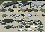
This library is derived using models from some of my already released custom sceneries as well as numerous new objects. Most of the objects are found at military bases and share a common green/brown pallete that is prevalent in many Western European Countries. The object of this library is to allow users to quickly set up a bare minimum scenery for themselves or add more detail to any existing scenery. Library includes over 120 objects including Barracks/Dormitory Buildings, Utility Buildings, Unimog-type vehicles, Avionics Objects, Shelters, Hangars, and more. All objects are XML based and can be placed with most scenery programs.
| Filename: | European_Military_Object_Library.zip |
| License: | Freeware, limited distribution |
| Added: | 4th May 2014, 19:27:27 |
| Downloads: | 1,138 |
| Author: | John Stinstrom |
| Size: | 6.1 MB |
| Category: Flight Simulator 2004 - Scenery | |
| EGDG - RAF St. Mawgan - Newquay, Cornwall - UK |
|
Images related to this file:
File Description:

Representative scenery of RAF. St. Mawgan in Cornwall. Opened as a civilian airfield in 1933, it was requistioned by the Royal Air Force in 1939. After use as a satellite field, it was taken over by Coastal Command in 1951 and since has been connected with that particular role, having Shackelton, Canberra, Wessex and Nimrod all flying from there at one point or another. The airfield is now home to the RAF SERE training unit. The bulk of the airfield was handed over to civilian use in 2008. This scenery has been made using various scenery libraries, mainly from MAIW. Full listing in the docs.
| Filename: | EGDG__RAF_St_Mawgan__Newquay_Cornwall__UK.zip |
| License: | Freeware, limited distribution |
| Added: | 5th October 2014, 11:17:11 |
| Downloads: | 1,663 |
| Author: | Brian Clarke, Daryl Payne, Stewart Pearson |
| Size: | 675.59 KB |
| Category: Flight Simulator 2004 - Scenery | |
| Barnstable/Boardman-Polando |
|
File Description:
FS2004 Scenery-Barnstable Muni-Boardman/Polando Field Airport (KHYA) in Massachusettes serves Hyannis and Barnstable County and is owned by Town Of Barnstable. The airport has more than one runway. The longest is a paved runway extending 5425 feet. The facility is at an elevation of 55 feet at a distance of about one mile from Hyannis. Created with EZ Scenery. EZ Scenery libraries required. New objects and textures by the author are included. Three AFCAD2 files are included for the default FS9 roads, USA Roads and Ultimate Terrain users. PLEASE READ THE README FILE!!! The UT AFCAD2 by Ray Lunning. Scenery by John B. Loney, Jr.
| Filename: | BarnstableBoardmanPolando.zip |
| License: | Freeware, limited distribution |
| Added: | 8th February 2007, 01:32:56 |
| Downloads: | 1,301 |
| Author: | John B. Loney, Jr. |
| Size: | 2.22 MB |
| Category: Flight Simulator 2004 - Scenery | |
| Walvis Bay International Airport, Namibia (FYWB) |
|
Images related to this file:
File Description:
A custom Gmax made Walvis Bay International Airport (FYWB) in Namibia. This representation still has the old terminal building before it was rebuilt into the current structure. The scenery consist of custom made models with photorealistic textures and a photoreal ground that blends nicely with the dessert surroundings. This scenery was around 90% completed when I stopped to wait for the new terminal to be finished, but I have since lost all my source files and as such I am releasing this as is (with the old terminal still in use). The scenery only covers the airport and so the Rooikop Army Base is not included.
| Filename: | Walvis_Bay_International_Airport_Namibia_FYWB.zip |
| License: | Freeware, limited distribution |
| Added: | 9th March 2021, 05:29:38 |
| Downloads: | 216 |
| Author: | Kobus van Wyk |
| Size: | 4.68 MB |
| Category: Flight Simulator 2004 - Scenery | |
| Niederstetten-Army Update |
|
File Description:
UPDATE UPDATE UPDATE UPDATE UPDATE UPDATE UPDATE UPDATE UPDATE UPDATE UPDATE
FS2002/FS2004 Scenery - Niederstetten Army Ver2.5
Niederstetten-Army (ETHN) are one of the oldest military Heliport at south of Germany. From here there are starting a lot of AMF-Flight´s around the NATO Country´s. At the last years, they are fling to Norway (Bardufoss-AAB), Turky, (Erzerum),....). The last fife year´s the Airport have mad a good job and now from here are starting any civil Airplan´s e.g. WÜRTH, EBM,... to Traffel around the world. At the weekend´s there are start´s smal Probs to find new airprt in Europe.
| Filename: | NiederstettenArmy_Update.zip |
| License: | Freeware |
| Added: | 3rd December 2003, 00:32:08 |
| Downloads: | 3,554 |
| Author: | Edgar Stahl |
| Size: | 4.34 MB |
| Category: Flight Simulator 2004 - Scenery | |
| Cordova Smith PACV & Municipal CKU in Alaska US |
|
Images related to this file:
File Description:
Cordova is on the south coast of Alaska, around 150 miles east of Anchorage and 45 miles south of Valdez. The town is mainly built on a small but relatively flat area between the east side of Prince William Sound and Eyak Lake, and has a population of around 2,350 in 2010, the approximate date of this scenery.
The Municipal Airfield CKU is on the north side of Eyak Lake to the east of Cordova, with the runway that is 1,800 feet of unlit gravel squeezed between the lake and the road that runs around the lake. The hangars and parking aprons are reached by taxiing across, and to some extent along, the road. Float planes are also taken from the lake to an apron to the west of the runway.
Cordova Airport PACV (named in the real world "Merle K. (Mudhole) Smith", and I will leave you to research this) is known as Cordova Smith in FS9 and is 10 miles to the east of the town on relatively flat ground between mountains to the north and the sea to the south. The runway is 8,080 feet of lit asphalt aligned 09-27 with ILS on runway 27 and VASI on both ends. The aprons are to the north side of the runway and are reached by back-taxiing; there are no taxiways parallel to the runway. The main apron serves Alaska Air via the western of two taxiways. The GA parking and hangars are mainly reached by using the eastern taxiway, though there is in fact a connecting taxiway between the two (for GA, but definitely not for airliner use). The taxiway further to the west serves the separated Alaska Coastguard apron and hangar, which is mainly for helicopter use. There is a nominally grass runway 1,900 feet long and aligned 16-34 to the south of the main runway; in fact it appears to be more gravel than grass. I have left this inactive as otherwise AI Alaska Air planes would be attempting to use this when the wind made it seem like a good idea.
The AI includes Alaska Air (twice a day) and also Coastguard helicopters, along with GA.
| Filename: | Cordova_Smith_PACV__Municipal_CKU_in_Alaska_US.zip |
| License: | Freeware, limited distribution |
| Added: | 22nd January 2022, 21:53:03 |
| Downloads: | 145 |
| Author: | Roger Wensley |
| Size: | 16.93 MB |
| Category: Flight Simulator 2004 - Scenery | |
| Prince George CYXS in British Columbia, Canada |
|
File Description:
Prince George is centrally located in British Columbia, mid way between the border with the USA in the south and the northern border with the Northern Territories, and around 100 miles west of the eastern border with Alberta. The town now has a population of around 74,000 and is regarded as the province's northern capital. It is at the meeting point of the Fraser and Nechako rivers and the crossroads of highways 16 and 97. It started out as Fort George in the early 1800's when a trading post was established by the Northwest Company,serviced by paddle boats on the rivers. The railway arrived in the area in 1914 and growth continued, albeit slowly due to wars and the financial collapse of the 1930's. Timber and timber products were and still are the mainstay of the area, along with a military and governmental presence.
The date for this scenery is around 2010. I have made some new buildings from memory and the available information online. They are not totally accurate reproductions; for instance I know that the terminal building is brick faced and also has parts that are stone (or metal?) faced, but where? So I used brick everywhere. The control tower is also brick faced, but is not exactly the right shape. The airport management team have continued to grow the activity and services provided with the result that flights and passenger numbers continue to increase. The 15-33 runway was lengthened to the south, (in the period 2003 to 2005) from the original FS9 scenery 7,400 feet to my updated 11,450 feet with central lighting and ILS at the northern end. This made it the third longest runway in Canada. At the same time a loading/unloading cargo area was created with professionally run storage and also a large scale refueling storage. If DHL want to refuel their 737 then they can do so without making prior arrangements.
The AI included here is for Air Canada Jazz and an Air Canada 737, Westjet 737 and Dash8, a helicopter company that is based there, Pacific Coastal, Central Mountain Air, and GA. The range of airlines and planes reflects the "northern capital" status of the town.
| Filename: | Prince_George_CYXS_in_British_Columbia_Canada.zip |
| License: | Freeware, limited distribution |
| Added: | 11th November 2022, 23:10:19 |
| Downloads: | 158 |
| Author: | Roger Wensley |
| Size: | 28.04 MB |
© 2001-2026 AVSIM Online
All Rights Reserved
Privacy Policy |