
Where Flight Simulation Enthusiasts Gather from Around the World!
AVSIM Library - Search Results

| Category: Flight Simulator 2004 - Scenery | |
| Nicholson Peninsula CWNP & Liverpool Bay CWLB DEW sites in Northwest Territories, Canada |

|
Images related to this file:
File Description:
These are DEW line sites in northern mainland Canada, to the east of Tuktoyaktuk.
Nicholson Peninsula is 100 miles east of Tuktoyaktuk and was not included in FS9. The peninsula is sometimes more like an island than a peninsula as it is barely connected to the mainland and at times is not connected at all (see the current Gogle Earth!). At the northern end there is another long and narrow gravel bar that is formed by the tide and currents and the gravel runway is on the top of this. It is now officially closed, but is still usable. The annual refuelling and maintenance to the NSW station up on the hills is carried out from a barge that lands tanker trucks onto the shore for the drive up the existing gravel roads that have been there since the early DEW station was established.
Liverpool Bay is 50 miles east of Tuktoyaktuk, up on higher land at around 300 feet ASL. The NWS (there was no previous DEW station at this site) is serviced by helicopter from Tuktoyaktuk or from a barge a mile away on the beach. There is a gravel landing pad on the north side of the station. To answer your question, the three little houses on stilts are actually fuel tanks for the generators, shaped to shed snow.
| Filename: | Nicholson_Peninsula_CWNP__Liverpool_Bay_CWLB_DEW_s.zip |
| License: | Freeware, limited distribution |
| Added: | 17th July 2012, 18:55:24 |
| Downloads: | 236 |
| Author: | Roger Wensley |
| Size: | 1.84 MB |
| Category: Flight Simulator 2004 - Scenery | |
| Haines Junction CYHT in Yukon Territory Canada |
|
Images related to this file:
File Description:
Haines Junction is a village in the Yukon Territory, Canada, amid the Rocky Mountains and around 80 miles west of Whitehorse. It is sited at the junction of the Haines Highway and the Alaska Highway, hence the name. The village was established in 1942 when the Alaska Highway was under construction, and the Haines Highway was built over the Chilkat Pass to connect to the town of Haines on the Alaska coast.
The date of this scenery is, as usual, around 2010. At that time there was a regular service (not always a daily one, depending on the time of year) by Yukon Air North, and in this case it is by an ATR 42-300. There is a helicopter company based at the airfield, Trans North Helicopters, and there is also Kluane Glacier Air Tours, which, as the name suggests, takes you to a glacier so you can stroll around on ice. And then brings you back. The gravel runway is 5,000 feet long and aligned 04-22, and is lit, with PAPI at both ends. Right hand circuits are required for runway 04 as the terrain is not flat.
This post will be followed by two other airfields to the northwest, Silver City and Burwash, both of which are on or close to the Alaska Highway.
| Filename: | Haines_Junction_CYHT_in_Yukon_Territory_Canada.zip |
| License: | Freeware, limited distribution |
| Added: | 22nd January 2022, 21:53:16 |
| Downloads: | 115 |
| Author: | Roger Wensley |
| Size: | 20.46 MB |
| Category: Flight Simulator 2004 - Scenery | |
| Nikolski (IKO), Nelson Lagoon (Z73), & Perryville (AK5) - Alaska, USA |
|
Images related to this file:
File Description:
These are villages in Alaska, spread out east and west of Dutch Harbor in the Aleutians and the peninsula, served by Grant Aviation regional flights from Dutch Harbor, Cold Bay, or King Salmon.
Nikolski is 115 miles west of Dutch Harbor at the western end of Umnak Island, which is just west of Unalaska, the large island adjacent to Dutch Harbor. Nikolski is small, with a population of perhaps only 20 now, and the main claim to fame is the wrecked Reeve Aleutian DC3 at the end of the runway. The runway is 3,500 feet of gravel aligned 08-26. Nelson Lagoon is on the north shore of the peninsula, 55 miles north of Sand Point and on a long spit of land that curves around to make the lagoon. There is no access except by boat or plane for the population of around 50. The airfield is a mile east of the village with a gravel runway 08-26, 4,000 feet long. Perryville is on the south shore of the peninsula, 65 miles east of Sand Point. The population is around 115, and the airfield is southwest of the town with the 3,500 feet of gravel runway aligned 02-20 beside the shore. There is a hangar on the apron, but no terminal building.
| Filename: | Nikolski_IKO_Nelson_Lagoon_Z73__Perryville_AK5__Al.zip |
| License: | Freeware, limited distribution |
| Added: | 14th March 2015, 13:27:53 |
| Downloads: | 255 |
| Author: | Roger Wensley |
| Size: | 11.45 MB |
| Category: Flight Simulator 2004 - Scenery | |
| Ford India Project Compilation |
|
Images related to this file:
File Description:

This zip contains the entire Ford India Project from the inception seed airfield of Pondicherry (Part1) through to the completion of Part4. A total of 24 historically rendered (1930's) airfields. This is the first 4 parts all rolled into one for a project that is planned to be 7 parts - to see detailed descriptions and images visit http://www.ford-tri-motor.net/ford-india-project.htm
Contained in the pack is the historically rendered SCENERY Only for the following airfields:PONDICHERRY, COLOMBO, HYDERABAD, BOMBAY, AHMEDABAD, KARACHI, INDORE, MADRAS (Principle), MADRAS (Alternative), CALCUTTA, ALLAHABAD, CHITTAGONG, NAGPUR, DELHI, JODHPUR, CAWNPORE, BANGKOK, BASSEIN, AKYAH, RANGOON, KUALA LUMPUR (Principle), KUALA LUMPUR (Alternative), PENANG and SINGAPORE.
There is also a comprehensive aircraft AI Pack available on the Ford-Tri-Motor.net site that has a collection of historical aircraft using the above airfields for circuits and some transit between some of the airfields. Visit http://www.ford-tri-motor.net/ford-india-project.htm to get them for Free.
For simmers that have parts of the Project this zip will ensure that they have the complete current components of the project, for new patrons this will install all of the project to date. It will be a couple of months before the remaining Parts,5,6 and 7 are completed.
Project Manager - Edward C. Moore
Project Developer- Garry J. Smith
| Filename: | Ford_India_Project_Compilation.zip |
| License: | Freeware, limited distribution |
| Added: | 16th August 2013, 20:32:47 |
| Downloads: | 294 |
| Author: | Edward Moore & Garry Smith |
| Size: | 9.79 MB |
| Category: Flight Simulator 2004 - Scenery | |
| Carp CYRP updated, near Ottawa in Ontario Canada |
|
Images related to this file:
File Description:
This version updates the post of 2006 with specifically modelled buildings for the east apron, plus a new AFCAD file. This is a stand-alone version and does not require you to have downloaded and installed the previous post. Carp airfield is fifteen miles west of Ottawa and two miles south of the town of Carp. There are two runways, 10/28 which is asphalt and almost 4,000 feet long and 100 feet wide, and 04/22 which is gravel and 2,000 feet long. The airfield has a fairly large polulation of general aviation residents and two years ago was expanding under new ownership, with a new terminal building and a large hangar opened and the "Touch'n Go" aviation warehouse that has opened more recently. The first version of Carp really included only the west apron, as that is where all (or almost all) the general aviation is located. I "represented" the east apron buildings without modelling any of them. This version corrects that, and the modeled east apron buildings are the HQ of Helicopter Transport Services Inc. and the adjacent Bell Helicopter service hangar, and the old First Air hangar and offices which are now under new ownership. The smaller hangars on the other side of the apron belong to chapter 245 of the Experimental Aircraft Association.
| Filename: | Carp_CYRP_updated_near_Ottawa_in_Ontario_Canada.zip |
| License: | Freeware, limited distribution |
| Added: | 16th February 2010, 03:18:39 |
| Downloads: | 562 |
| Author: | Roger Wensley |
| Size: | 6.03 MB |
| Category: Flight Simulator 2004 - Scenery | |
| CYSM - Fort Smith, Northwest Territories, Canada |
|
Images related to this file:
File Description:
Fort Smith is just north of the border between Alberta and Northwestern Territories, midway between Lake Athabasca to the southeast in (mostly) Saskatchewan (80 miles) and Great Slave Lake to the north west (90 miles). The runways all used to be larger, and while I don't know the history it looks as if it is ex-military and these are the remains of what were once 10,000 feet of asphalt. The main runway is now 11/29 and 6,000 feet long, and the secondary one is 1,800 feet of mostly gravel. There is an airline based at the field, Northwestern Air, and fuel (both 100LL and JA-1) is available at a self service point so long as you give it a credit card to read while you fill. The town of Fort Smith is two miles east of the airfield, on the bank of the Slave River and where there are some rapids that require a portage to get around them. Before aviation came along the river was a major route to the north and all those furry animals, which was why the Hudson's Bay Company established an outpost there in 1872. Today it has a population of 2,400 and the main activities are government administration of much of the Northwest Territories, education, and tourism.
| Filename: | CYSM__Fort_Smith_Northwest_Territories_Canada.zip |
| License: | Freeware, limited distribution |
| Added: | 28th January 2012, 17:11:47 |
| Downloads: | 592 |
| Author: | Roger Wensley |
| Size: | 4.29 MB |
| Category: Flight Simulator 2004 - Scenery | |
| Ontario Small Fields in Canada: #05 Pelee Island (CYPT) |
|
Images related to this file:
File Description:
This is the fifth in a series of small airfields in southern Ontario Canada, Pelee Island CYPT, an airfield on the island in Lake Erie and the southernmost airfield in Canada. The airfield has an asphalt runway of 3,300 feet, aligned 09/27 in FS9 while today in real life it is 10/28 due to the wandering magnetic pole. There is also a second runway, 36/18 and around 1,500 feet of gravel. There is a small terminal building which now has blue cladding; here it is still in the dirty yellow of the original colour scheme.
This version is based upon what appears to be a "lost" 2005 scenery of Pelee Island. When I started to make Pelee Island I discovered that in fact I already had a version installed; my memory can be excused, as I installed it in 2005. I modified the scenery to include parking, taxiways that connected, revised runway markings, new windsocks, new signage, larger apron, parked cars and planes, revised landclass, AI, etc. My intention was to instruct you to download and install the original and then incorporate my changes. Problem: it does not appear to exist for download; perhaps it was washed away when the Avsim site crashed. I have included it in this post. If anyone knows who made it please let me know.
| Filename: | Ontario_Small_Fields_in_Canada_05_Pelee_Island_CYP.zip |
| License: | Freeware, limited distribution |
| Added: | 5th August 2015, 18:52:25 |
| Downloads: | 170 |
| Author: | Roger Wensley |
| Size: | 4.39 MB |
| Category: Flight Simulator 2004 - Scenery | |
| LFRD2004 Dinard/St-Malo VFR Scenery |
|
Images related to this file:
File Description:
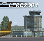
LFRD is a regional airport in Brittany, France. This scenery was created entirely with GMax and the latest Microsoft compilers. Everything was made to ensure maximum framerate while giving maximum visual impact, even on humbler machines. This scenery will run just as fast as the default one (which is very bare) with your current settings, even though there are literally thousands of houses, buildings, trees and a detailed airport.
This is a complete package:
-SRTM local mesh with custom coast trimming
-Custom phototexture (200sq km), with seamless blending into FS9 standard landclass
-Full autogen with custom local texture
-Custom landclass and waterclass
-AFCAD2 file with parking codes
-Custom Hi-res photographic textures at airport.
-Gmax buildings and xml librairy objects.
It was made by a real life pilot and is totally aimed at recreating the feeling of being there, not so much on the ground (after all, this is a FLIGHT simulator), but at circuit altitudes. This is not about recreating an airport in all its glorious details at the cost of framerate, but instead an exercise in balancing visual cues and details as viewed from up there to make it 'as real as it gets' within the limits of FS9. Scenery made by Vauchez (http://mapage.noos.fr/euro_vauchez/)
| Filename: | LFRD2004_DinardStMalo_VFR_Scenery.zip |
| License: | Freeware, limited distribution |
| Added: | 28th April 2010, 18:06:05 |
| Downloads: | 46,559 |
| Author: | Etienne Vauchez |
| Size: | 10.55 MB |
| Category: Flight Simulator 2004 - Scenery | |
| PAEN, PAEX, 3AK4, 30AK, 52AK - Alaska, USA |
|
Images related to this file:
File Description:
The town of Kenai is on the east coast of Cook Inlet, 60 miles southwest of Anchorage. The airport is in the northern part of the town, with a runway aligned 1-19, 7,550 feet long and 150 feet wide (with an ILS on 19). A second runway is gravel, 2,000 feet long and for winter use by ski planes. There is also a water runway, and all three are aligned the same and called "1 left-19 right" (the main runway) "1 right-19 left" (gravel) and "1 water-19 water". The taxiways are extensive and designed for a far larger traffic than the airport has today, though even now the airport is fairly busy. In FS9 a water runway for AI cannot work with an ATC control tower; the water part of PAEN has therefore been separated into another call sign PAEX which has ONLY the water runway; the tower will therefore direct the plane that makes contact to use the water runway. The PAEN airport runway has taxiway connections at each end and also two intermediates; at the northern end there are in fact two so a total of 5; B, C, D, E, and F; there is an airport diagram included. GA traffic goes to one of two parking aprons, both at the southern end, and at the far southern end there is the hangar for the Civil Air Patrol. The AI includes aircraft from my previous Alaska posts, as Kenai is where I sent them when they departed from, for instance, Palmer. Airlines and cargo companies that operate from and to Kenai are included in the AI: ERA (which has recently changed it's name), Grant Aviation, Air North, Wings of Alaska, North Star Air, and a small local company Air Supply Alaska, along with Fedex, UPS, Everts, and Northern Air Cargo. There is also GA and float AI. Nearby smaller airfields are included, partly because one of them was dramatically misaligned in FS9.
| Filename: | PAEN_PAEX_3AK4_30AK_52AK___Alaska_USA.zip |
| License: | Freeware, limited distribution |
| Added: | 26th December 2015, 15:33:19 |
| Downloads: | 482 |
| Author: | Roger Wensley |
| Size: | 23.08 MB |
| Category: Flight Simulator 2004 - Scenery | |
| Lake Athabasca Airfields in Alberta & Saskatchewan Canada |
|
Images related to this file:
File Description:
These are four airfields around or near Lake Athabasca, in Alberta and Saskatchewan. Fort Chipewyan CYPY is at the southwestern end of the lake and the direct recipient of pollution that flows north from the Tar Sands to the south. The population of around 850 lives in one of the earliest European settlements in Alberta, founded as a trading post by Peter Pond of the Northwest Company in 1788 and named for the Chipewyan people who lived in the area. The airfield has one runway aligned 03-21 and 5,000 feet of asphalt, with PAPI at both ends. The landclass has been modified along with the grassed area of the airfield to create the village on the lakeshore. There are scheduled flights and GA flights in the AI for all four airfields. Charlot River CJP9 is on the northern shore at the western end of the lake, in Saskatchewan. It serves a nearby hydroelectric project and is used to transport technical staff in and out. There is no terminal building, only waiting pickup trucks and a generator building. There is one lit gravel runway aligned 04-22 and just over 3,200 feet long. Fond-du-Lac CZFD is on the northern shore in Saskatchewan, at the narrower eastern end. The population is around 900 and is a remotely situated "fly-in" village that has existed for over 150 years where "living off the land" is an accepted and normal way of life. The village has been created along with the airfield. The single runway is 3,800 feet of lit gravel aligned 10-28 with PAPI at the western end. Stony Rapids CYSF is east of the end of Lake Athabasca, on the Fond du Lac River. It has a population of around 250 and is only semi-connected to the rest of Canada by a rough gravel road. The runway is over 5,000 feet of gravel, aligned 06-24 with PAPI at both ends. The NorthSKlake is a flatten for an Ultimate Terrain lake that was at an incorrect elevation.
| Filename: | Lake_Athabasca_Airfields_in_Alberta__Saskatchewan_.zip |
| License: | Freeware, limited distribution |
| Added: | 7th August 2018, 12:39:52 |
| Downloads: | 175 |
| Author: | Roger Wensley |
| Size: | 20.36 MB |
© 2001-2026 AVSIM Online
All Rights Reserved
Privacy Policy |