
Where Flight Simulation Enthusiasts Gather from Around the World!
AVSIM Library - Search Results

| Category: Flight Simulator 2004 - Scenery | |
| "Himalayan Peaks" LOD10 Mesh, Volume 3 - Namcha Barwa |

|
File Description:
Highly detailed terrain mesh of the Namcha Barwa area, N29°-31° E94°-96°. The files in this package are based on Shuttle Radar (SRTM) Version 2 data but with many of the void areas, especially the most significant sections, filled with elevation data generated from topographic maps by Jonathan de Ferranti. While Jonathan's work is unrelated to flight simulation he kindly gave me permission to compile his data for use in FS. The result is a wonderful improvement in detail and accuracy over any existing mesh file, freeware or commercial, based on SRTM or DTED data alone. Due to the large area of the Himalayas I've compiled the source data as two separate series: the "Himalayan Peaks" series covers prominent mountains and ranges in higher detail and locally overrides any existing LOD9 terrain mesh. In addition, a LOD9 "base mesh" series covering the entire Himalayas will be available for those who do not yet have an add-on terrain mesh of these beautiful mountains.
| Filename: | Himalayan_Peaks_LOD10_Mesh_Volume_3__Namcha_Barwa.zip |
| License: | Freeware, limited distribution |
| Added: | 18th February 2006, 23:15:17 |
| Downloads: | 12,192 |
| Author: | Holger Sandmann and Jonathan de Ferranti |
| Size: | 15.09 MB |
| Category: Flight Simulator 2004 - Scenery | |
| "Himalayan Peaks" LOD10 Mesh, Volume 5 - Garhwal |
|
File Description:
Highly detailed terrain mesh of the Garhwal area, N30°-32° E78°-81°. The files in this package are based on Shuttle Radar (SRTM) Version 2 data but with many of the void areas, especially the most significant sections, filled with elevation data generated from topographic maps by Jonathan de Ferranti. While Jonathan's work is unrelated to flight simulation he kindly gave me permission to compile his data for use in FS. The result is a wonderful improvement in detail and accuracy over any existing mesh file, freeware or commercial, based on SRTM or DTED data alone. Due to the large area of the Himalayas I've compiled the source data as two separate series: the "Himalayan Peaks" series covers prominent mountains and ranges in higher detail and locally overrides any existing LOD9 terrain mesh. In addition, a LOD9 "base mesh" series covering the entire Himalayas will be available for those who do not yet have an add-on terrain mesh of these beautiful mountains.
| Filename: | Himalayan_Peaks_LOD10_Mesh_Volume_5__Garhwal.zip |
| License: | Freeware, limited distribution |
| Added: | 18th February 2006, 23:16:47 |
| Downloads: | 10,138 |
| Author: | Holger Sandmann and Jonathan de Ferranti |
| Size: | 27.72 MB |
| Category: Flight Simulator 2004 - Scenery | |
| Himalayan Peaks LOD10 Mesh, Volume 1 - Mt. Everest and Kula Kangri |
|
File Description:
Highly detailed terrain mesh of the Mt. Everest and Kula Kangri areas, N26°-29° E85°-92°. The files in this package are based on Shuttle Radar (SRTM) Version 2 data but with many of the void areas, especially the most significant sections, filled with elevation data generated from topographic maps by Jonathan de Ferranti. While Jonathan's work is unrelated to flight simulation he kindly gave me permission to compile his data for use in FS. The result is a wonderful improvement in detail and accuracy over any existing mesh file, freeware or commercial, based on SRTM or DTED data alone. Due to the large area of the Himalayas I've compiled the source data as two separate series: the "Himalayan Peaks" series covers prominent mountains and ranges in higher detail and locally overrides any existing LOD9 terrain mesh. In addition, a LOD9 "base mesh" series covering the entire Himalayas will be available for those who do not yet have an add-on terrain mesh of these beautiful mountains.
| Filename: | Himalayan_Peaks_LOD10_Mesh_Volume_1__Mt_Everest_an.zip |
| License: | Freeware, limited distribution |
| Added: | 9th February 2006, 22:13:00 |
| Downloads: | 37,056 |
| Author: | Holger Sandmann and Jonathan de Ferranti |
| Size: | 52.01 MB |
| Category: Flight Simulator 2004 - Aircraft Repaints, Textures and Modifications | |
| Repaints and Panel Updates for YAK-18T |
|
File Description:
This package contains 2 different textures and a panel modification.
-1st repaint: RA44400, (I corrected some small issues from my previous upload)
this repaint is from a real Yak-18T. Check http://www.russianaeros.com/yak18Tproduct.htm.
-2nd repaint: N416RG, this is a new repaint from a Yak-18T flown by Ross Granley in aerobatic airshows in Canada and USA.
I have fixed the manifold pressure gauge, added a "post-it" with some useful flight data, and added sub panels to access some gauges/switches without leaving the VC.
You need the following files prior using these repaints and panel modification:
* Original Aircraft: yak-18t.zip (FlightSim) or yakovlev_yak-18t.zip (AVSIM) - from the original Design Team Alexey Yuzefov, George Sukhykh, Alexander Aphonin, Dmitry Shvetsov and Mike Maarse.
* 2.2 Yak-18T Update: yak18a22.zip - from Wolfram Beckert & Nick Schreger (MeatWater), who updated this great Freeware airplane.
| Filename: | Repaints_and_Panel_Updates_for_YAK18T.zip |
| License: | Freeware |
| Added: | 12th January 2008, 04:08:59 |
| Downloads: | 3,078 |
| Author: | Steffen Moessner |
| Size: | 11.82 MB |
| Category: Flight Simulator 2004 - Gauges | |
| Digital Clock and Stopwatch |
|
File Description:
This is a Digital Clock & Stopwatch for FS2004 which reads in
Hours:Minutes:Seconds
There are two versions:
LCD (Black figures on Grey-Green background))
LED (Orange figures on Black background)
This gauge replaces my earlier stopwatch which reset
when travelling across time zones!
This stopwatch is not affected by time zones.
Thanks to Guenther "GKCherry1" for testing and evaluating.
It has a Start/Stop function and a Reset function.
When not functioning as a Stopwatch it will display the Local Time
The output is linked to the Simulator clock variable:
If you pause the simulation the timer pauses.
If you change the simulation rate the timer rate changes accordingly.
If you stop the clock then the display remains visible at the stop time.
If you re-start it continues counting from where you stopped.
(There is no 'lap' function)
Pressing RESET zeros the timer and shows the clock.
| Filename: | Digital_Clock_and_Stopwatch.zip |
| License: | Freeware |
| Added: | 7th May 2006, 08:00:23 |
| Downloads: | 3,145 |
| Author: | Jim Cooper |
| Size: | 530.57 KB |
| Category: Flight Simulator 2004 - Original Aircraft | |
| Socata TB20GT Trinidad, v2.0 |
|
Images related to this file:
File Description:

Socata TB20GT Trinidad Public Release v2.0
NOTE: FS9 (aka: Century of Flight) ONLY! This will NOT work in FS2002!
A complete new build of the "Developer's Award" winning Socata TB20GT for FS9! Three liveries are included: G-TTAC by Bill Leaming, "Betty Blue" and "Red Rider" by Kim Staneart.
The SOCATA TB20 Trinidad aircraft is a 4-5 seat training, business and travel machine. GMax design, retractable gear with full moving parts, tinted cabin windows, two gull-wing doors, and variable pitch propeller. Highly detailed, night lighted Virtual Cockpit! "Dynamic Shine" and "Reflections" enabled.
Features Garmin 530 GPS, TCAS Radar, Bendix-King slaved HSI (NAV1), Bendix-King VOR2 ILS/GS (NAV2) Bendix-King dual-needle RMI (ADF+NAV2), Bendix-King ADF, Bendix-King DME (NAV1/2 selectable) Bendix-King Transponder, 2x Bendix-King COM/NAV radios, KMA 28 Bendix-King Audio Control w/ OMI indicators, MAP/FuelFlow on P2, Tachometer on P2, EDM 700 CHT/EGT and Shadin Fuel Management Computer on P2, Astrotech LC2 Chronometer Yoke mounted. (R)
| Filename: | Socata_TB20GT_Trinidad_v20.zip |
| License: | Freeware |
| Added: | 27th May 2010, 20:48:02 |
| Downloads: | 31,902 |
| Author: | Fr. Bill Leaming, Factory Aircraft Rebuilders |
| Size: | 9.4 MB |
| Category: Flight Simulator 2004 - Miscellaneous Files | |
| ActiveSky Weather Adventures Vol. 2 - Fly the AT! |
|
File Description:
ActiveSky Weather Adventures Vol. 2 - Fly the AT! (Includes updated Vol. 1 - Winter's End) ***In addition to archives for AS2k4 users, saved flights with AS2k4 processed weather are included so people who don't own ActiveSky can fully enjoy these adventures and get a taste of what ActiveSky 2k4 has to offer! * Includes TWO Volumes of Weather Adventures * Volume 2 - Fly the AT! - Ten flights take you from Maine to Georgia along route of the Appalachian Trail - features three days of real-weather as a slow front approaches from the west - can YOU make it to Georgia before the thunder rolls in? * Volume 1 includes 10 flights highlighting weather phenomena such as a tornado outbreak in Texas and Oklahoma, a New England "nor'easter", and a massive upper-level low occupying the plains states! ***The ASWxAd-Kneeboard!*** A modification to FS9's kneeboard which allows viewing of original material describing these flights, radar and satellite loops, and annotated sectionals depicting flight plans and the AT! * This is the Automatic Installer version. A manual install is also available - ASAS2MAN.zip * Previous version had nearly 2000 downloads!
| Filename: | ActiveSky_Weather_Adventures_Vol_2__Fly_the_AT.zip |
| License: | Freeware, limited distribution |
| Added: | 4th June 2004, 14:14:58 |
| Downloads: | 2,798 |
| Author: | Scott Gridley |
| Size: | 22.04 MB |
| Category: Flight Simulator 2004 - Miscellaneous Files | |
| Active ILS - KMCO (Orlando International Airport) |
|
File Description:
This is the 3rd Airport in a series of new ILS runways. As most know initiating the ILS at certain airports for AI Traffic is not a function at this time when using AFCAD2. If you add a new ILS runway to an airport such as KMCO (Orlando International Airport 17L/35R) only the user aircraft can use this runway when visibility falls below 3 miles. ATC will no longer use this runway for AI Traffic because FS9 sees it as a visual runway. This will cause ATC to vector your AI Traffic back to 17/35 (old numbers) 17R/35L (new numbers) which is also a Terminal departure runway. This file adds all NAVAIDS for making 17L/35R a Precision Instrument Runway. I have added all the radar fixes for both the ILS approach portion and the proper missed approach procedures, altitudes and intersections as per current published plates. All AI Aircraft will now continue to use 17L/35R when Airport visual conditions are less than 3 miles.
| Filename: | Active_ILS__KMCO_Orlando_International_Airport.zip |
| License: | Freeware, limited distribution |
| Added: | 25th June 2004, 01:50:15 |
| Downloads: | 3,846 |
| Author: | Jim Vile |
| Size: | 45.38 KB |
| Category: Flight Simulator 2004 - Aircraft Repaints, Textures and Modifications | |
| Americana de Aviacion Douglas DC-6 |
|
Images related to this file:
File Description:
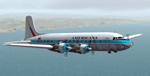
Textures for Tom Gibson's Douglas DC-6 - repainted by Manfred Meyer.
You need to download and install the latest Douglas DC-6 base pack with model, sound and panel from the website calclassic.com.
These textures depict HC-ARK "El Pinguino" (c/n 42865) of Americana de Aviacion. This Ecuadorian Company leased and later bought this plane in 1968 and used it, among others, for flights to the Galapagos Islands.
This DC-6 was the 13. built and originally delivered 1947 to American Airlines as "Flagship Texas" renamed later "Flagship South Carolina". American AL sold her 1960 to Aerolineas Peruanas as OB-OAD-545. From 1964 onwards she was in the hands of some U.S.leasing companies and goes then to Americana of Ecuador. They used the plane until 1970 and then it was broken up at Quito after 1975.
The Lettering "DC-6 EQUIPADO CON RADAR" should be on the nose wheel doors, but unfortunately this is not possible at this FS model. So I put the text on the lower bow near the nose wheel bay.
| Filename: | Americana_de_Aviacion_Douglas_DC6.zip |
| License: | Freeware |
| Added: | 11th September 2014, 22:51:29 |
| Downloads: | 193 |
| Author: | Manfred Meyer |
| Size: | 8.25 MB |
| Category: Flight Simulator 2004 - Aircraft Repaints, Textures and Modifications | |
| USAF/MATS Convair CV-240 VBF |
|
Images related to this file:
File Description:
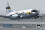
FS2004 USAF/MATS Convair CV-240 VBF in colors of 1952. The Convair with cn 264 was one of a bunch of T-29B-CO (CV-240-27) delivered to the U.S. Air Force September 16, 1952 and on July 15, 1953 assigned to the 1299 Transport Squadron of Military Air Transport Service (MATS). She was equipped with standard high density seating for staff transport and painted in the typically MATS livery of the early fifties. On July 13, 1956 she was converted to VC-131A standard and fitted with the weather mapping radar used extensively on the model CV-440 and on many CV-340 models. The last operator of this Convair was the 86th Tactical Fighter Wing based at Stuttgart (Germany). She came to AMARC on May 06, 1975 and was sold off for scrap on November 23, 1994. Textures and associated model file included only. Requires cv240VBFmilitary_basepack_010.ZIP. Original by Greg Pepper & Tom Gibson, upgraded by Georg Hauzenberger (model) and Hans Hermann (textures) Virtual Birds Factory, March 2011
| Filename: | USAFMATS_Convair_CV240_VBF.zip |
| License: | Freeware, limited distribution |
| Added: | 29th March 2011, 00:54:27 |
| Downloads: | 816 |
| Author: | Georg Hauzenberger and Hans Hermann |
| Size: | 4.76 MB |


© 2001-2026 AVSIM Online
All Rights Reserved
Privacy Policy |