
Where Flight Simulation Enthusiasts Gather from Around the World!
AVSIM Library - Search Results

| Category: Flight Simulator 2004 - AI Aircraft | |
| Sukhoi Su-25 Frogfoot (Part 5) |

|
Images related to this file:
File Description:

Sukhoi Su-25 Frogfoot (Part 5). I present a comprehensive AI traffic model package for this close air support aircraft. The Su-25, known as the Grach (Rook), was put into service in 1981, was designed as a comparable aircraft to the USAF A-10 Warthog, focused on battlefield close air support. Starting with Afghanistan, the Su-25 proved itself to be an extremely versatile and survivable aircraft, and has been in service ever since. Just over 1,000 were built in various models, and have been or are operated by thirty countries. An original 8-LOD model brings this historic aircraft to the flightsim world. This is part 5, combined with Parts 4 and 6, representing the Su-25 in all operational models (Su-25, Su-25M1, Su-25T, Su-25UB, Su-25UTG), in the past and current service of all export or Soviet successor states excluding the export users in part 1; with 34 models and 247 repaints. For those who only want one era or the other in their flightsim world, a detailed explanation of current or past users is in the documentation. Aircraft, textures, and flight dynamics by Michael Pearson.
| Filename: | Sukhoi_Su25_Frogfoot_Part_5.zip |
| License: | Freeware |
| Added: | 3rd June 2014, 21:11:15 |
| Downloads: | 416 |
| Author: | Michael Pearson |
| Size: | 38.91 MB |
| Category: Flight Simulator 2004 - AI Aircraft | |
| Sukhoi Su-25 Frogfoot (Part 4) |
|
Images related to this file:
File Description:

Sukhoi Su-25 Frogfoot (Part 4). I present a comprehensive AI traffic model package for this close air support aircraft. The Su-25, known as the Grach (Rook), was put into service in 1981, was designed as a comparable aircraft to the USAF A-10 Warthog, focused on battlefield close air support. Starting with Afghanistan, the Su-25 proved itself to be an extremely versatile and survivable aircraft, and has been in service ever since. Just over 1,000 were built in various models, and have been or are operated by thirty countries. An original 8-LOD model brings this historic aircraft to the flightsim world. This is part 4, combined with Parts 5 and 6, representing the Su-25 in all operational models (Su-25, Su-25M1, Su-25T, Su-25UB, Su-25UTG), in the past and current service of all export or Soviet successor states excluding the export users in part 1; with 34 models and 247 repaints. For those who only want one era or the other in their flightsim world, a detailed explanation of current or past users is in the documentation. Aircraft, textures, and flight dynamics by Michael Pearson.
| Filename: | Sukhoi_Su25_Frogfoot_Part_4.zip |
| License: | Freeware |
| Added: | 3rd June 2014, 21:10:50 |
| Downloads: | 383 |
| Author: | Michael Pearson |
| Size: | 12.1 MB |
| Category: Flight Simulator 2004 - Original Aircraft | |
| AerMacchi C.202 FOLGORE (Lightning) EXPANSION PACK 2 |
|
Images related to this file:
File Description:
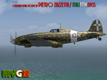
The C.202 Folgore was a World War II fighter aircraft built by Macchi Aeronautica and operated by the Regia Aeronautica (Royal Italian Air Force). Considered one of the most beautiful fighters to fly with wartime Axis forces,the C.202 was a development of the earlier C.200 Saetta,with a more powerful German Daimler-Benz DB 601 engine and with an extremely streamlined fuselage.Undoubtedly the best wartime fighter to serve in large numbers with the Regia Aeronautica,the Folgore operated on all fronts in which Italy was involved.
ATTENTION, this is only an upgrade package,so you MUST have already installed the main package 'c202_v01.zip'and the Expansion Pack 1 'C202_EP1.zip'.
Contains 2 NEW Hi-Res GMax models (2 different versions) feature the usual moving parts, such as all flight controls, props pitch and leading edge flaps. Eight (6) different liveries. VC only. GMax Models and Skins by Manuele Villa, Huub Vink & Italianwings, Flight dynamics by Manuele Villa & Kikko Zanaboni. It also works (Tested) subject to some limitations within FSX. By Manuele Villa/MVG3D,June 2012.
| Filename: | AerMacchi_C202_FOLGORE_Lightning_EXPANSION_PACK_2.zip |
| License: | Freeware |
| Added: | 4th July 2012, 18:02:07 |
| Downloads: | 895 |
| Author: | Manuele Villa, Italianwings |
| Size: | 17.28 MB |
| Category: Flight Simulator 2004 - Scenery | |
| Forggensee, v2 Update |
|
Images related to this file:
File Description:

This UPDATE enhances the existing Forggensee Water-Airport(EDAF).
Klaus Jone did a magnificent job in creating this scenery for us flightsimmers, and my enhancements do NOT alter any Scenery Objects by Klaus Jone. The buildings are the same. And the number of AI planes and ships are unchanged.
My enhancements modify the BEHAVIOR of the Ships.
But the floatplane traffic is so superbly programmed that no further modifications are necessary.
Mr. Klaus Jone passed away in May 2009, and it is my intention to preserve Forggensee pretty much as HE designed it. Except for modifying the BEHAVIOR of the AI traffic, to spread it out to cover the entire area of Lake Forggensee. As the screenshots I've included illustrate.
Naturally, these updated files require that Forggensee Part 1 and Part 2 are ALREADY installed in your FS2004. My part here was to perform a few tweaks to make the AI traffic spread out all over Lake Forggensee, and ensure that ALL wake/spray effects are visible. As Klaus Jone stated: "There is some amazing traffic on the lake, have a look and have fun!"
| Filename: | Forggensee_v2_Update.zip |
| License: | Freeware |
| Added: | 18th April 2011, 19:13:38 |
| Downloads: | 727 |
| Author: | Klaus Jone, Ronald Falzon |
| Size: | 1.41 MB |
| Category: Flight Simulator 2004 - Scenery | |
| Alps LOD10 Topo Mesh - Austria and Italy |
|
Images related to this file:
File Description:
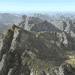
Yet another terrain mesh package of the European Alps? Well, this one is different in that it is NOT primarily based on the Shuttle Radar (SRTM) data with their incomplete coverage of prominent peaks and ridges. Instead, most of the source data for this project were developed over many months by Jonathan de Ferranti using detailed topographic maps. While Jonathan's work is unrelated to flight simulation he kindly gave me permission to compile his data for use in FS. The result is a wonderful improvement in detail and accuracy over any existing SRTM- or DTED-based mesh file, freeware or commercial (a link to an extensive set of screenshot comparisons is included in the read-me file).
I've compiled the source data at LOD10 (38-m) grid resolution because the coverage area is smaller than most existing mesh files. Thus, anyone can use these files without having to first uninstall their current mesh set. Also included are LOD9 and LO8 buffer mesh files. Note: if you own Austria Professional 2004 with its 1:50,000 scale terrain mesh then you don't need this package!
| Filename: | Alps_LOD10_Topo_Mesh__Austria_and_Italy.zip |
| License: | Freeware, limited distribution |
| Added: | 30th May 2010, 09:46:58 |
| Downloads: | 62,954 |
| Author: | Holger Sandmann, Jonathan de Ferranti |
| Size: | 73.32 MB |
| Category: Flight Simulator 2004 - Scenery | |
| Kugluktuk CYCO in Nunavut, Canada |
|
Images related to this file:
File Description:
Kugluktuk is on the coast of northern mainland Canada on the mouth of the Coppermine River. It is around 250 miles west of Cambridge Bay and 200 miles south of Ulukhaktok. Tuktoyaktuk is 450 miles west. Kugluktuk used to be called Coppermine as copper was mined along the banks of the river and used for spear and arrow heads, and this attracted a semi-permanent population. The population now numbers around 1,450. The airfield is inland from the village and the 5,500 feet of 100 feet wide gravel runway is aligned 121T/3301T where T stands for "true" as opposed to magnetic in the Northern Domestic Airspace. Both JETA-1 and 100LL are available, dispensed by a truck as the storage tanks are just off the northern edge of the field. There are flights by First Air and Canadian North and the AI includes a daily flight of each, plus a cargo visit by Buffalo; the closest large city is Yellowknife, 375 miles south. I should have mentioned a long time ago that to see the apron lights working requires you to have the "lights_ss_v2" by Sidney Schwartz installed.
| Filename: | Kugluktuk_CYCO_in_Nunavut_Canada.zip |
| License: | Freeware |
| Added: | 10th November 2012, 04:03:35 |
| Downloads: | 429 |
| Author: | Roger Wensley |
| Size: | 3.04 MB |
| Category: Flight Simulator 2004 - Scenery | |
| Alaska South Slope 2 - Noorvik ORV in AK US |
|
Images related to this file:
File Description:
The town of Kotzebue is in the far northwest of Alaska, and these are villages to the north and the east of Kotzebue on the South Slope of the Brooks Range of mountains. There will be further additions. Noorvik is a small village (population now around 670) on the bank of the Kobuk River, around 50 miles east of Kotzebue. The new airfield is 1 mile south of the village; there is a short runway immediately south of the town that is now closed but is not marked as such and appears to be usable; this will still be listed in FS9 when you are presented with a choice of runways but is not connected in any way to the new airfield so ignore it. The new ORV runway has 4,000 feet of lit gravel aligned 06-24. There are scheduled flights by Era (now renamed Ravn) and by Bering Air, both of them originating in Kotzebue and routing east to Noorvik, Kiana, Ambler, Shungnak, Kobuk, and then back again. The AI includes these flights (eventually) plus perhaps an Everts Air cargo flight and GA.
| Filename: | Alaska_South_Slope_2__Noorvik_ORV_in_AK_US.zip |
| License: | Freeware, limited distribution |
| Added: | 4th September 2016, 18:20:02 |
| Downloads: | 221 |
| Author: | Roger Wensley |
| Size: | 3.95 MB |
| Category: Flight Simulator 2004 - Panels | |
| Generic Customized Advanced Panels |
|
File Description:
FS2004 Generic Advanced Customized Panels. Since this panel includes All XML gauges for 2-, 3- and 4 Jet engines aircrafts, Concorde and Warplains for 1 and 2 Engines, including landing panel. Special effects of the visor in the mainpanel of the Concorde. It can be used for any heavy jet. Also you have 3 choices, between the metal gray color panel (old Boeing) or the brown color of the FS2004 boeing default and the feeling to be in a Airbus (PFD of A380). All gauges are on the same place in the different engine version or airplane, no more memorizing the different panels. It has a full working overhead, TCAS radar, ATC control, customized FS2004 GPS, ACS-GPS, APU, FMC, HUD, Wiper and many custom xml gauges. Special attention is made on the Radio, Fuel, PFD, Clock, Taxi speed control, Wind speed, Bank rate, Auto mb-Hg, Push back,and Sim speed. A lot of information during take off, flight and landing. Many warnings included. Ideal panel for beginners and advanced simmers. Special Credit of gauges to Acsoft, Arne Bartels, Eric Mariano, Björn Karlsson, Tony d'Ambrosi, Nick Pike, etc. Panel design and gauges by Guy de Smet.
| Filename: | Generic_Customized_Advanced_Panels.zip |
| License: | Freeware |
| Added: | 16th January 2004, 23:00:39 |
| Downloads: | 16,068 |
| Author: | Guy De Smet |
| Size: | 10.3 MB |
| Category: Flight Simulator 2004 - Scenery | |
| Paulatuk CYPC in the Northwest Territories, Canada |
|
Images related to this file:
File Description:
Paulatuk is on the coast of northern mainland Canada, 200 miles east of Tuktoyaktuk and 170 miles southwest of Ulukhaktok. It is just to the east of the Parry Peninsula, which has at its northern tip the Cape Parry DEW line Main Station. Paulatuk was established in the 1920's, and the population now numbers around 320. Paulatuk airfield is close to the village but on higher ground, while the village follows the curve of the coast. The 4,000 feet of 100 feet wide gravel runway is aligned 021T/201T where T stands for "true" as opposed to magnetic in the Northern Domestic Airspace. Only JETA-1 is available unless there is 100LL in drums. There are flights by Aklak Air from Inuvik, which is around 250 miles to the west; Aklak Air is actually Kenn Borek under a diferent name. The AI is for a daily passenger flight, and for a cargo flight on Wednesdays. In the summer, float planes use the lake to the south of the village, but I have no information as to docks or any other facilities; probably there aren't any.
| Filename: | Paulatuk_CYPC_in_the_Northwest_Territories_Canada.zip |
| License: | Freeware, limited distribution |
| Added: | 3rd December 2012, 21:58:47 |
| Downloads: | 278 |
| Author: | Roger Wensley |
| Size: | 4.39 MB |
| Category: Flight Simulator 2004 - Scenery | |
| NZAA auckland airport for fs9/fs2004 |
|
File Description:
Auckland Airport[5] (IATA: AKL, ICAO: NZAA) is an international airport serving Auckland, the most populous city of New Zealand. It is the largest and busiest airport in the country, with over 16 million passengers served in the year ended August 2023.[6] The airport is located near Māngere, a residential suburb, and Airport Oaks, a service-hub suburb 21 kilometres (13 mi) south of the Auckland city centre. It serves as the principal hub for Air New Zealand and the New Zealand operating base for Jetstar.
Features of this scenery include:
1)Highly modeled terminals and buildings
2)roads and highways
3)surrounding warehouses
4)Custom ground poly LINES
5)lots of ground equipment
6)3d grass
7)trees----> have seasonal issues but will update once fixed
8)cars and fences
9)custom textures and night lighting
10)2 major hotels near the international terminal
11)Accurate taxiways and hangars
12) Localizer antennas
13)street lights
Please put these files in the addon scenery folder of your FS9 directory
And add in fs
They shouldn't cause any issues.
(http://www.mediafire.com/file/emh3ksaq3nd7igk/real_new_zealand_auckland_city.rar) link for the city.
| Filename: | NZAA_auckland_airport_for_fs9fs2004.zip |
| License: | Freeware |
| Added: | 26th April 2025, 14:00:30 |
| Downloads: | 370 |
| Author: | Jeremy Paul Joby |
| Size: | 91.51 MB |


© 2001-2026 AVSIM Online
All Rights Reserved
Privacy Policy |