
Where Flight Simulation Enthusiasts Gather from Around the World!
AVSIM Library - Search Results

| Category: Flight Simulator 2004 - Aircraft Repaints, Textures and Modifications | |
| P-51D Mustang "Upupa Epops" |

|
File Description:
This is a repaint pack only for the WWII Fighters P-51D. P-51D 44-72364 was built at the North American Aviation Inglewood plant in 1944. It was sent into action with the 353rd Fighter Group, 352nd Fighter Squadron, 8th Air Force. The aircraft was flown by Capt. Harrison "Bud" Tordoff, who named it "Upupa Epops", latin for the Hoopoe Bird which has ungainly flight. At war's end Bud Torduff had claimed nine enemy airplanes shot down, one of them an Me-262 shot down while flying "Upupa Epops." After the war the aircraft was sent to the Royal Swedish Air Force, then flew with the Dominican Air Force from 1952 until 1984. Paul Allen, of Microsoft fame, purchased the aircraft in 1999, adding it to his growing muesum, the Flying Heritage Collection. The aircraft immediately went to WestPac, in California, for restoration. During this time period it was restored inside and out, matching every component to every specification of the original, utilizing documents upon documents of information. When the aircraft completed restoration in 2001, it was the most original, most authentic of its type. After several test flights in its factory finish, the original "Upupa Epops" markings were applied. Currently the aircraft can be seen at its newest home, with the Flying Heritage Collection, at Paine Field, near Seattle. Included within this download are two repaints, one portrays exactly how "Upupa Epops" looked when it rolled out of WestPac's shop after restoration, in factory standard, and the second portrays the aircraft complete with markings.
| Filename: | P51D_Mustang_Upupa_Epops.zip |
| License: | Shareware, honor system |
| Added: | 4th October 2007, 09:34:12 |
| Downloads: | 329 |
| Author: | John Terrell |
| Size: | 14.43 MB |
| Category: Flight Simulator 2004 - Scenery | |
| Amundsen-Scott Station |
|
File Description:
The Amundsen-Scott South Pole Station is the American scientific research station on the high plateau of Antarctica. This station is located at the southernmost place on the Earth, the Geographic South Pole, at an elevation of 2,835 meters (9301 feet) above sea level.
Since the Amundsen-Scott Station is located at the South Pole, it is at the only place on the land surface of the Earth where the sun is continuously up for six months and then continuously down for six months. (The only other such place is at the North Pole, on the sea ice in the middle of the Arctic Ocean.) Thus, during each year, this station experiences one extremely long "day" and one extremely long "night". During the six-month "day", the angle of elevation of the Sun above the horizon varies continuously. The sun rises on the September equinox, reaches its maximum angle above the horizon on the summer solstice in the Southern Hemisphere, around 20 December, and sets onthe March equinox.
During the six-month "night", it gets extremely cold at the South Pole, with air temperatures sometimes dropping below -73 C (-100 F). This is also the time of the year when blizzards, sometimes with gale-force winds, strike the Amundsen-Scott Station. The continuous period of darkness and dry atmosphere make the station an excellent place from which to make astronomical observations.
This file has the apron and characteristics of the airport the coordenates are placed as far south FS allow it.
| Filename: | AmundsenScott_Station.zip |
| License: | Freeware |
| Added: | 17th October 2011, 22:02:39 |
| Downloads: | 668 |
| Author: | Anwar Gonzalez |
| Size: | 5.92 KB |
| Category: Flight Simulator 2004 - Scenery | |
| CYQS - St Thomas - Ontario, Canada *V1* |
|
Images related to this file:
File Description:
St Thomas is a town in Ontario around 12 miles south of London and less than 10 miles from the north shore of Lake Erie, with a population of just under 40,000. The airport (actually more of an airfield, as there are no scheduled flights) has three runways typical of an ex-military field, with one remaining hangar from RCAF flight training times in the 1940's, and the east-west runway now extended to just over 5,000 feet. The main presence at CYQS is a company in the crop seeding and spraying business over a wide area of Ontario; as a result there are several AT-802 planes based there which are included here as AI planes and also as parked scenery objects. To the west of the original apron area there are added taxiways to cater for a herd of new individual hangars wearing orange and white uniforms. There is fuel, runway lighting on 09-27, taxiway lights, visitor parking on the edge of the apron, and maintenance companies in the large hangars, plus a flight training group. A small terminal building sits quietly between hangars, waiting. Ditches along the road and around much of the airfield provide separation, which is why the fences are not continuous. I presume that the warning balls on the electricity cables were found to be necessary to persuade pilots not to land there; probably ski planes in winter, they tend to land anywhere so long as it has snow on it. This V1 version includes previous updates.
| Filename: | CYQS__St_Thomas__Ontario_Canada_V1.zip |
| License: | Freeware, limited distribution |
| Added: | 30th August 2015, 02:35:28 |
| Downloads: | 265 |
| Author: | Roger Wensley |
| Size: | 11.13 MB |
| Category: Flight Simulator 2004 - Scenery | |
| KLBB - Lubbock Preston Smith Intl - Texas V3.0.1 |
|
Images related to this file:
File Description:

Lubbock is another one of those little known, neglected airports that populate the
FS world. Avery simple airport, LBB somewhat feels like a little DFW. There is a very DFW-ish main terminal with fewer than
10 gates and plenty of space to grow. The only mainline service is courtesy Southwest, but several RJ's freqent Lubbock
several times per day along with the big freighters. This airport was built from the ground up with excellent detail,
and because of the sparse traffic, frame rates are excellent as well.
V2.0 Update:
Recently, Lubbock has moved their east-west runway 8/26 roughly 1000 feet to the East so as to eliminate runway incursions
by separation from the north-south runway 17R-35L. Version 2.0 reflects this modificaton. Several taxiways have been removed
or modified, and airport fencing has been altered to reflect the change.
V3.0 Update:
This update fixes some major errors mainly on the West side of the airport. The cargo ramp and some of the GA parking had been
found to be located in the wrong positions. They have been relocated and rebuilt to match GoogleEarth images. Also, the afcad
has been updated to line up with these changes along with airline parking updates at the main terminal. All the jetways have
been replaced with more accurate representations, and they have also been adjusted to match their current real world positioning.
v3.0.1 update:
There was a missing scenery library that has been added to the download, so now the jetways will appear if they had not before.
| Filename: | KLBB__Lubbock_Preston_Smith_Intl__Texas__V301.zip |
| License: | Freeware |
| Added: | 18th May 2013, 07:39:35 |
| Downloads: | 1,551 |
| Author: | FRFStudio.net / William Morgan |
| Size: | 8.17 MB |
| Category: Flight Simulator 2004 - Scenery | |
| Naknek (5NK) and Naknek South (WSN) - Alaska, USA |
|
Images related to this file:
File Description:
Naknek and Naknek South are two towns close to the mouth of the Naknek River and on opposite banks. King Salmon is approximately 15 miles to the east. The canneries on both banks of the river are the reason for the existence of both towns and airfields, with fishing for salmon being the primary industry of the area. This takes place from the beach by individuals, by small boats in the river and the immediate sea area, and offshore by larger craft. There is a picture of one boat unloading in Naknek which will be known to anyone who has watched the most famous television fishing programme of all, Deadliest Catch. Cornelia Marie is better known for the crab fishing based in Dutch Harbor, but this area too is just as productive though without the drama. Naknek 5NK has two gravel runways and a float runway in the adjoining lake; all three are just under 2,000 feet long. Naknek South WSN has two gravel runways, 12-30 being 3,300 feet long and 04-22 2,260 feet. As the road connecting to King Salmon is on the north bank it is probable that more seasonal workers are brought into the southern canneries by air, hence the longer runway (and with PAPI on 12). Grant Aviation run scheduled flights into both and there are numerous seasonal charter flights. The AI is a further modification of that posted with King Salmon PAKN and includes these flights, and presumes that you have already downloaded PAKN.
| Filename: | Naknek_5NK_and_Naknek_South_WSN__Alaska_USA.zip |
| License: | Freeware, limited distribution |
| Added: | 29th April 2015, 20:44:31 |
| Downloads: | 217 |
| Author: | Roger Wensley |
| Size: | 6.09 MB |
| Category: Flight Simulator 2004 - AFCAD Files | |
| MATVA Afcads 7 |
|
File Description:
More improved airfields to replace those default airfields Microsoft have seen fit to provide little or no facilities at. The MATVA Group, www.matva.org.uk offer you another package of Af2 files for those airfields they visit, they do not have allocated gates. The 68 airfields in this package are:(EGPD) Aberdeen and (EGPM) Scatsta, Scotland, (LGAV) Athens, (LGRP) Rodos, (LGTS) Thessaloniki, (LGAL) Alexandropolous, Greece, (LGIR) Iraklion and (LGSA) Chania, Crete, (LTBJ) Izmir, Turkey, (LJLJ) Ljubljana, Slovenia, (LATI) Tirana, Albania, (LROP) Bucharest, Romania, (LYBE) Belgrade, Serbia, (LIPE) Bologna, Italy, (LWSK) Skopje, Macedonia, (LBSF) Sofia and (LBBG) Burgas, Bulgaria, (LHBP) Budapest, Hungary, (LPPR) Porto, Portugal, (EKEB) Esbjerg, Denmark, (FOOL) Libreville, (FOOT) Tchibanga, (FOON) Franceville and (FOOG) Port Gentil, Gabon, (DIAP) Abidjan, Cote D'Ivoire, (GFLL) Freetown, Sierra Leone, (DFFD) Oagadougou, Burkina, (GMME) Rabat, Morocco, (FLLS) Lusaka, Zambia, (HDAM) Djibouti, (GLRB) Monrovia, Liberia, (HUEN) Entebbe, Uganda, (DRRN) Niamey, Niger, (FVHA) Harare, Zimbabwe, (HTDA) Dar-Es-Salaam, Tanzania, (HHAS) Asmara, Eritrea, (FKKD) Douala and (FKKN) N'gaoundere, Cameroon, (FQBR) Biera, Mozambique, (FNLU) Luanda, Angola, (FYWH) Windhoek, Namibia, (HAAB) Addis Ababa, Ethiopia, (FCBB) Brazzaville, Congo, (FAJS) Johannesburg, (FGBT) Bata and (FGSL) Malabo, Equatorial Guinea, (FMMI) Antananarivo, Madagascar, (FPST) Sao Tome and (FPPR) Principe, Sao Tome et Principe, (FIMP) Mauritius, (FSIA) Seychelles, (GCXO) Tenerife North, (MMUN) Cancun and (MMAA) Acapulco, Mexico, (OERK) Riyadh, Saudi Arabia, (TBPB) Barbados. (SAEZ) Beunos Aires.
Also included are reworks of our previously released (HELX) Luxor, (RJBB) Osaka, (LGKR) Kerkira, (FACT) Cape Town, (FADN) Durban, (HKJK) Nairobi, (LFLL) Lyon, (DGAA) Accra, (FEFF) Bangui, Central African Rep. (GOOY) Dakar and (DAAG) Algiers. Enjoy :O)
| Filename: | MATVA_Afcads_7.zip |
| License: | Freeware, limited distribution |
| Added: | 23rd July 2006, 07:31:28 |
| Downloads: | 10,084 |
| Author: | Louie Maclennan MATVA |
| Size: | 242.36 KB |
| Category: Flight Simulator 2004 - Original Aircraft | |
| AerMacchi C.205 VELTRO (Greyhound) |
|
Images related to this file:
File Description:
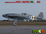
The Macchi C.205 (also known as MC.205,"MC" standing for "Macchi Castoldi") Veltro (Italian:Greyhound) was an Italian World War II fighter aircraft built by the Aeronautica Macchi.
The C.205 was a development of the earlier C.202 Folgore. With a top speed of some 400 mph and equipped with a pair of 20 mm cannon as well as 12.7 mm Breda machine guns, the Macchi C.205 Veltro was highly respected by Allied and Luftwaffe pilots alike. Regarded as the best Italian aircraft of World War II, in action it proved to be extremely effective, destroying a large number of Allied bombers and capable of successfully clashing on equal terms with such renowned fighters as the North American P-51D Mustang, but, although the C.205 was able to match the best Allied opponents in speed and manoeuvrability, it was introduced late in the conflict. Moreover, due to the poor Italian industrial capability of the time, only a small production run was delivered before the end of the war.
Italy's highest scoring ace, Adriano Visconti, achieved 11 of his 26 credited victories in the few weeks he was able to fly the Veltro, with the top scoring 205 Sergente Maggiore pilota Luigi Gorrini shooting down 14 enemy aircraft plus six damaged with the C.205.
VC only. GMax Models and Skins by Manuele Villa & Italianwings, Flight dynamics by Manuele Villa & Kikko Zanaboni. It also works (Tested), subject to some limitations, within FSX. By Manuele Villa/MVG3D, September 2012.
| Filename: | AerMacchi_C205_VELTRO_Greyhound.zip |
| License: | Freeware, limited distribution |
| Added: | 28th September 2012, 10:56:13 |
| Downloads: | 1,260 |
| Author: | Manuele Villa, Italianwings |
| Size: | 37.96 MB |
| Category: Flight Simulator 2004 - Scenery | |
| Beaver Creek CYXQ in Yukon Territory, Canada |
|
Images related to this file:
File Description:
Beaver Creek is located at mile 1202 of the Alaska Highway, just east of the Alaska/Yukon border. The populaton is around 100 and the main employment is with the Border Agency, the White River First Nation, or with local tourist lodges. The airfield is a mile north of the town and close to the Canadian border post, which is included in the scenery. It was built by Jack Stalberg in the 1960's, and I have no further information beyond the fact that he loved to fly. The airport serves as an "airport of entry", though it is restricted in hours of opening and in the size of aircraft that it can handle; up to a maximum of only 15 seats. The single runway is 3,745 feet long and 100 feet wide, gravel, aligned 13-31 in FS9, lit, and with vasi at both ends. Righthand circuits for runway 13. There is a 340 feet threshold displacement to runway 31, which is of course unmarked on a gravel runway. The terminal building was recently reclad; I don't like it, but they didn't consult me. The ai reflects the sort of traffic the airfield gets; ie brief paperwork stopovers for GA or small charter flights into Canada from Alaska, usually in the mornings.I have adjusted the local scenery terrain levels to remove adjacent hills that I believe do not exist in real life but are part of the Northern Canada terrain mesh that I have installed. If you do not have this mesh you may find that the scenery works fine for you without the API flatten that is included here. The airfield is at 2,129 feet ASL.
| Filename: | Beaver_Creek_CYXQ_in_Yukon_Territory_Canada.zip |
| License: | Freeware, limited distribution |
| Added: | 28th January 2019, 06:19:20 |
| Downloads: | 174 |
| Author: | Roger Wensley |
| Size: | 4.68 MB |
| Category: Flight Simulator 2004 - Scenery | |
| Fort Simpson Island CET4 - Northwest Territories, Canada |
|
Images related to this file:
File Description:
Fort Simpson Island is the fifth in a series of airfields that follow (approximately) in a southward direction the Mackenzie River. At the far northern end of the river there is Tuktoyaktuk, then Inuvik, Fort McPherson, Fort Good Hope, Deline, and then Wrigley, all posted. Fort Simpson Island is at 405 feet asl and on the west bank of the the Mackenzie, around 110 miles south of Wrigley at the junction of the Mackenzie and the Liard rivers. The town of Fort Simpson is on an island, and has a population of 1,250 or so folks. The Hudson Bay trading post was established here in 1822. The airport is right next to the town, and has 3,000 feet of gravel runway, though with a displaced threshold of 1,000 feet at each end (unmarked, on gravel) this is effectively 2,000 feet for landing. The Canada Flight Supplement lists the runway as being 100 feet wide; the gravel is definitely far less and the 100 refers to the width in the winter when you are landing on snow and don't care if there is gravel or grass underneath. There are no scheduled flights as these go to the nearby Fort Simpson CYFS. There is a mandatory radio frequency which is for both CYFS and CET4 and in this case I have set the "tower" to "manned" so you will report position and obey instructions. Runway 13 has right hand circuits. I have modified the Ultimate Terrain route for the Mackenzie Highway so that it remains on the west side of the river and does not wander randomly from one side to the other north of Fort Simpson.
| Filename: | Fort_Simpson_Island_CET4__Northwest_Territories_Ca.zip |
| License: | Freeware, limited distribution |
| Added: | 6th July 2014, 02:56:05 |
| Downloads: | 208 |
| Author: | Roger Wensley |
| Size: | 2.46 MB |
| Category: Flight Simulator 2004 - Scenery | |
| Golden CYGE in British Columbia, Canada |
|
Images related to this file:
File Description:
This airfield is in one of the north-south valleys in the Columbia Mountains (which are part of the Rockies) on the border between BC and Alberta. The town of Golden (population just under 4,000) grew along with the Canadian Pacific Railway and the logging industry, both of which are still the mainstays of the town. Tourism is a more recent development along with the Kicking Horse Mountain Resort, which is only 3 miles to the west of the town. There are occasional flights into CYGE related to the richer echelon of tourist groups for Kicking Horse, particularly at the weekends; three actual such flights are included in the AI. Golden CYGE is immediately to the west of the town beside the Columbia River, with the 4,500 feet of asphalt runway aligned 14-32; right hand circuits for 32. There are no runway lights or landing aids, and no taxiway lights, so this airfield is for daylight use only. There is a helicopter company based on the field (Alpine) and a volunteer search and rescue group, a skydiving operation at the northern end, plus an active club with a long open hangar with a club room. A friendly airfield. The AI helicopter was included in my post of Alma CYTF. The Beaver will not show up unless you have the Aerosoft Beaver installed. I found the other planes without a problem on flightsim or avsim. Due to the surrounding terrain AI aircraft will usually impact high ground before landing and then just show up on their parking spots. A northern wind improves but does not totally solve this.
| Filename: | Golden_CYGE_in_British_Columbia_Canada.zip |
| License: | Freeware, limited distribution |
| Added: | 29th September 2018, 19:26:13 |
| Downloads: | 156 |
| Author: | Roger Wensley |
| Size: | 12.2 MB |


© 2001-2026 AVSIM Online
All Rights Reserved
Privacy Policy |