
Where Flight Simulation Enthusiasts Gather from Around the World!
AVSIM Library - Search Results

| Category: Flight Simulator 2004 - Aircraft Repaints, Textures and Modifications | |
| Air Pink Cessna Citation Excel XLS+ (YU-BZM) |

|
Images related to this file:
File Description:
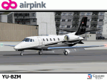
I am proud to present this detailed repaint of the Aryus Works freeware model of the Cessna Citation Excel XLS+, registration YU-BZM, in Air Pink's elegant black, gray and white livery. Air Pink is a private business jet charter airline based in in Belgrade, Serbia, established in 2004 as part of Pink International Company. It is based at Belgrade Nikola Tesla International Airport. Its fleet consists of this single Citation XLS+, 2 Cessna Citation II's, 2 Cessna Citation 550 Bravos and 1 Cessna Citation CJ2. Air Pink flies to destinations in Europe, the Middle East and North Africa. There are a lot of curves on this aircraft and I paid attention to painting their detail and creating as realistic a repaint as possible on this work. The textures in this repaint are 32-bit. This is a complete install; Aryus Works Citation Excel XLS+ model and air files are included. Panel and sound are from the default Lear45. PLEASE NOTE: I recreated several textures in this repaint out of respect for EagleSoft Development's texture Copyright. These EagleSoft textures were released in Aryus Works original Excel paintkit and were used without permission from EagleSoft Development. See Readme file for more details.
| Filename: | Air_Pink_Cessna_Citation_Excel_XLS_YUBZM.zip |
| License: | Freeware, limited distribution |
| Added: | 30th October 2010, 21:49:32 |
| Downloads: | 1,728 |
| Author: | Jeffrey S. Bryner, Aryus Works |
| Size: | 5.33 MB |
| Category: Flight Simulator 2004 - Aircraft Repaints, Textures and Modifications | |
| Korean Air Boeing 737-900 |
|
Images related to this file:
File Description:
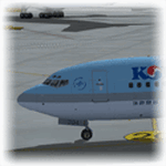
The Korean Air Boeing 737-900 for FS2004 (it should work in FSX), Korean Air, is both the flag carrier and the largest airline of South Korea, with global headquarters located in Seoul, South Korea. Korean Air's international passenger division and related subsidiary cargo division together serve 130 cities in 45 countries, while its domestic division serves 20 destinations. It is among the top 20 airlines in the world in terms of passengers carried and is also the top-ranked international cargo airline. Incheon International Airport serves as Korean Air's international hub. Korean Air also maintains a satellite headquarters campus at Incheon. Model by Project Open Sky.
Aqui esta el Boeing 737-900 de Korean Air para FS2004 (debe funcionar en FSX), Korean Air es la mayor aerolinea surcoreana con sede principal en la ciudad de Seul. Considerada entre las mas destacadas de Asia, opera conexiones hacia Europa, Africa, Asia, Oceania y Norte America ademas de iniciar operaciones proximamente hacia Suramerica desde su hub internacional en el Aeropuerto Internacional de Incheon y su hub domestico en el Aeropuerto Internacional de Gimpo. La empresa compite por su puesto como principal aerolinea del pais con Asiana Airlines, con menor cantidad de flota. Modelo de Project Open Sky.
| Filename: | Korean_Air_Boeing_737900.zip |
| License: | Freeware |
| Added: | 25th November 2011, 09:32:16 |
| Downloads: | 590 |
| Author: | Juan Rodriguez / AeroSimulaciones / Project Open Sky |
| Size: | 7.13 MB |
| Category: Flight Simulator 2004 - Scenery | |
| KQA Akutan, Alaska |
|
Images related to this file:
File Description:
This is Akutan, which comprises the water airport, the town, and the Trident crab and fish processing plant just to the west of the town. Akutan is in the Aleutians in an inlet on the island of the same name, around 35 miles ENE of Dutch Harbor, and is served by a Grumman Goose amphibian that flies from Dutch Harbor. The population is just over a thousand, though this can increase as more seasonal workers are employed at the plant. The church is not as big as it looks; the long part is a gymnasium. The Ai includes the Akutan end of a Grumman Goose flight from Dutch Harbour (the AI files are part of the Dutch Harbor scenery) which will take off from the Dutch Harbor runway and land on water at Akutan. It will then park at the bottom of the ramp up onto the apron, which is actually usable if you want to taxi up it. In reality it is a PenAir flight, here it is Reeve Aleutian for technical reasons. The Sea AI includes fishing boats from the Trident dock and a Coast Guard cutter from the town dock; the latter as explained in the updated version of Dutch Harbor, which you should already have installed.
| Filename: | KQA_Akutan_Alaska.zip |
| License: | Freeware, limited distribution |
| Added: | 10th August 2012, 16:54:02 |
| Downloads: | 492 |
| Author: | Roger Wensley + Sidney Schwartz |
| Size: | 3.17 MB |
| Category: Flight Simulator 2004 - Scenery | |
| CYHD - Dryden Regional - Ontario, Canada * Updated v2 * |
|
Images related to this file:
File Description:
This greatly modifies my previous (2009) post of Dryden; this version has bespoke buildings and is stand-alone and does not require you to have the previous post. There will also be follow-up posts of Sioux Lookout and Geraldton. Dryden is in northern Ontario, 110 miles east of the Manitoba border, 40 miles west of Sioux Lookout, and with the US border 90 miles to the south. The town is on the northern shore of Wabigoon Lake and has a population of around 7,800. The main business is pulp and paper, along with agriculture, tourism, and mining. The airport is 5 miles northeast of the town.
Dryden Regional has 6,000' of asphalt which in FS9 is aligned 11-29. The second runway is compacted sand 2,000' long and aligned 05-23. There are two aprons, the western being for the terminal building and some ga parking, and the eastern larger and used in the summer for parking fire fighting planes, along with maintenance hangarage and accomodation etc. The Ontario Fire Service planes were included with my original Geraldton post and are included here again; they fly back and forth and keep Dryden busy along with several Bearskin Airlines and Perimeter Aviation flights.
| Filename: | CYHD__Dryden_Regional__Ontario_Canada___Updated_v2.zip |
| License: | Freeware, limited distribution |
| Added: | 16th March 2013, 09:59:52 |
| Downloads: | 595 |
| Author: | Roger Wensley |
| Size: | 26.99 MB |
| Category: Flight Simulator 2004 - Scenery | |
| Peawanuck CYPO / Winisk CYWN - Northern Ontario, Canada |
|
Images related to this file:
File Description:
Peawanuck is on the bank of the Winisk River, 23 miles upstream from where the river empties into the Hudson Bay just west of James Bay. It has a population of around 240, and was established in 1986 when the original settlement (Winisk) at the mouth of the river was destroyed by a flood. The airport is on a bluff in a corner of the river at 171 feet ASL, with a gravel runway just over 3,500 feet long and aligned 11-29. There is only basic runway lighting, with no ILS, VASI, or PAPI; there is also no apron lighting, or fuel. Service is provided by Air Creebec with connector flights to Moosonee and Timmins, and on to Montreal. A search of their timetable did not provide any information regarding timings but I made the AI flight from Timmins a daily one; it is probably only once or twice a week. There is also a daily private Cessna from Moosonee. Winisk, at the mouth of the river, has another gravel runway which is over 6,000 feet long. There is also a large hangar and to the north the remaining buildings and fuel tanks etc of a Radar Control site which was closed in 1965 after only 7 years of use.
| Filename: | Peawanuck_CYPO__Winisk_CYWN__Northern_Ontario_Cana.zip |
| License: | Freeware, limited distribution |
| Added: | 29th December 2012, 09:14:03 |
| Downloads: | 281 |
| Author: | Roger Wensley |
| Size: | 2.61 MB |
| Category: Flight Simulator 2004 - Scenery | |
| Kangiqsualujjuaq CYLU in northern Quebec, Canada |
|
Images related to this file:
File Description:
Kangiqsualujjuaq is in northern Quebec on the east side of Ungava Bay, which is to the east of Hudson Bay and around 150 miles wide and 120 miles deep. Kuujjuaq, the administrative capital of northern Quebec, is 100 miles to the southwest. The town is on the bank of the George River, and has also been known as Fort George River, George River, etc. There was a Hudson Bay trading post at the town's location as early as 1838, though it was closed and reopened more than once and the town did not grow because of the trading post; the Inuit lived on the coast during the summer but moved 30 miles inland in winter for trapping. A cooperative was formed in 1959 to market fish, and this was the creative force that brought about establishment of the town; a school was built in 1963.
The airport is to the north of the town in a valley between the surrounding hills at 215 feet ASL. The gravel runway is just over 3,500 feet long and aligned 16/34; there is no PAPI, but there is fuel available, both 100LL and JetA. There are flights by Air Inuit and a warning of caribou on the runway during October and November.
| Filename: | Kangiqsualujjuaq_CYLU_in_northern_Quebec_Canada.zip |
| License: | Freeware, limited distribution |
| Added: | 1st February 2013, 21:24:55 |
| Downloads: | 277 |
| Author: | Roger Wensley |
| Size: | 2.76 MB |
| Category: Flight Simulator 2004 - Aircraft Repaints, Textures and Modifications | |
| Qantas Airbus A380-842 (VH-OQJ) |
|
Images related to this file:
File Description:

Qantas is the flag carrier airline of Australia. The name was originally "QANTAS", an acronym for "Queensland and Northern Territory Aerial Services".
Nicknamed "The Flying Kangaroo", Qantas is Australia's largest airline, and the second oldest in the world. Founded in November 1920, it began flying international services in May 1935.
The airline is based in the Sydney suburb of Mascot with its main hub at Sydney Airport.
Qantas livery painted on Project Airbus's Airbus A380-841 model. The textures are saved in 32bit format for quality graphics. Textures are also characterized by HD (High Definition). Its features are idle-reverser animation, animated pack vents and pressurisation outflow valve, detailed textures, accurate paint, dynamic shine & effects, dynamic flexing wings that respond to turbulence, fully independent suspension, trim animation, gear steering, accurate flight dynamics, spoiler animation, reflective cockpit windows, improved wingflex code with input from several new parameters including ground spoilers, fuel load, and angle of attack, transparent navigation light lenses and many more.
Visit my Facebook page "Sky Level Textures" for news, updates and previews on my future repaint projects. Thanks for downloading & Happy flying. HD GAMING EXPERIENCE inside, TEXTURES ALSO COMPATIBLE WITH FSX. https://www.facebook.com/SkyLevelTextures
| Filename: | Qantas_Airbus_A380842_VHOQJ.zip |
| License: | Freeware |
| Added: | 8th June 2014, 19:46:34 |
| Downloads: | 2,232 |
| Author: | Giacomo Tomasini | Sky Level Textures | Project Airbus |
| Size: | 23.98 MB |
| Category: Flight Simulator 2004 - Scenery | |
| CYQU - Grande Prairie, Alberta, Canada |
|
Images related to this file:
File Description:
Grande Prairie is at 2,195 feet asl, 65 miles southeast of Dawsons Creek, 90 miles southwest of Peace River and around 60 miles east of the Rockies. The town has a population of 55,000 and growing. The airport is just to the west of the town and was originally a military base, built during WW2. The two runways are 07-25 and 11-29 and when one is the active runway then the other is used as a taxiway. AI in FS9 doesn't like this, and just stops at the first hold short without ever reaching the active runway. I have found a way to overcome this and AI will now use taxiway A and whichever runway is inactive to feed to and from both ends of the active runway. The vertical red tanks are for de-icing fluid; de-icing is carried out before take-off in the winter. The industrial area to the southeast is now larger than I have made it, but I kept it to this minimum size to keep frame rates down. All the buildings are modeled specifically for CYQU. The AI includes Westjet, Air Canada Jazz, and others as listed. The GA AI uses only FS9 standard aircraft.
| Filename: | CYQU__Grande_Prairie_Alberta_Canada.zip |
| License: | Freeware, limited distribution |
| Added: | 9th May 2014, 10:05:40 |
| Downloads: | 670 |
| Author: | Roger Wensley |
| Size: | 18.33 MB |
| Category: Flight Simulator 2004 - Scenery | |
| CYDA - Dawson City - Yukon Territory, Canada |
|
Images related to this file:
File Description:
Dawson City is in the Yukon Territory, Canada, 140 miles south of Old Crow and about the same north of Whitehorse. The town has a population of just over 1,300 and is on the bank of the Yukon River; it is busy with nearby gold mining and tourism. There are regular flights by Air North, the Yukon airline, and I have included them in the AI along with ConAir and GA. Thanks go to Hernan for his Air North textures. The airport is beside the Klondike Highway that links Dawson City to Whitehorse, a few miles southwest of the town and the river. The runway approaches are steeper than most because of the surrounding hills and the Canada Flight Supplement notes that use is restricted to daylight hours, with some exceptions including emergencies. Runway 20 has right hand circuits. The runway is gravel and just over 5,000 feet long, aligned 02-20. There is a second apron for the activities of ConAir etc in the summer fire-fighting months. The "masts" are actually for fire hose drying; the ends of several 50 feet lengths are attached to a circular holder that is then pulled up to the top of the central pole.
| Filename: | CYDA__Dawson_City__Yukon_Territory_Canada.zip |
| License: | Freeware, limited distribution |
| Added: | 27th December 2014, 20:31:31 |
| Downloads: | 378 |
| Author: | Roger Wensley |
| Size: | 3.96 MB |
| Category: Flight Simulator 2004 - Scenery | |
| PAAQ - Palmer Muni - Anchorage, Alaska - USA |
|
Images related to this file:
File Description:
Palmer PAAQ is in Alaska, some 40 miles northeast of Anchorage on the north side of Knik Arm and beside the west bank of the Matanuska River. It is for both GA and commercial aircraft. There are two apron areas, north and south, separated by the east-west runway. The north apron is for the Forestry Service planes and for resident GA tie-down places and hangars, along with maintenance facilities; the southern end of the north apron is for itinerant aircraft. The south apron is almost entirely for commercial companies and again maintenance. The main runway is just under 6,000 feet long, aligned L16-R34 and asphalted and lit, as is the parallel taxiway A. There is also a shorter and parallel runway that is grass and which receives no winter maintenance. The second main runway is 3,600 feet long and aligned 09-27, asphalt and lit and with a parallel taxiway B, also lit. The airport is undergoing a process of upgrading, which explains the varied colours (and age) of resurfaced taxiways. There are adjustment bgl's for two other neighbourhood airstrips, Toad Lake 24AK and Wolf Track 9AK8, which I just discovered buried in nearby holes in the ground; I also revised their runway surfaces.
| Filename: | PAAQ__Palmer_Muni__Anchorage_Alaska__USA.zip |
| License: | Freeware, limited distribution |
| Added: | 4th November 2014, 00:01:43 |
| Downloads: | 447 |
| Author: | Roger Wensley |
| Size: | 22.35 MB |


© 2001-2026 AVSIM Online
All Rights Reserved
Privacy Policy |