
Where Flight Simulation Enthusiasts Gather from Around the World!
AVSIM Library - Search Results

| Category: Flight Simulator 2004 - Miscellaneous Files | |
| MV challenge - Canadian Arctic 2 |

|
File Description:
FS2004 MV challenge - Canadian Arctic 2.
Pilot a very tough round trip with ten legs
and 17 landings, mostly on gravel strips,
around Baffin Island in northeastern Canada,
in a Twin Otter. The challenge includes
bad weather, poor visibility, limited navaids
and mostly night-flying.
Requires: add-on Twin Otter and DEW Line scenery.
Optional: add-on Nunavut mesh and approach plates.
Freeware
| Filename: | MV_challenge__Canadian_Arctic_2.zip |
| License: | Freeware, limited distribution |
| Added: | 19th February 2005, 15:49:15 |
| Downloads: | 1,077 |
| Author: | Michael Vone |
| Size: | 1.22 MB |
| Category: Flight Simulator 2004 - Scenery | |
| VFR Balice EPKK ext II V2 |
|
Images related to this file:
File Description:
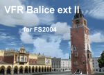
Very beautiful VFR scenery. Designed on ground textures of the old town Krakow in
the vicinity of EPKK Balice (Poland). This is an extension II of the base scenery VFR Balice with day and night textures. Almost one thousand 3D objects and photorealistic textures. Scenery does not contain EPKK airport itself and a mesh. EPKK airport can be
downloaded from www.pl-vacc.org
| Filename: | VFR_Balice_EPKK_ext_II__V2.zip |
| License: | Freeware, limited distribution |
| Added: | 6th May 2010, 18:50:18 |
| Downloads: | 2,076 |
| Author: | Lothar Tomczyk, Jakub Mista, Artur Apryjas |
| Size: | 42.01 MB |
| Category: Flight Simulator 2004 - Scenery | |
| FS2004 detailed KWYS Yellowstone |
|
File Description:
FS2004 EZ-LAGO KWYS Yellowstone
This detailed scenery replaces my previous KWYS and is FSX ready.
Covers airport and some surrounding area. Area outside of
airport needs FS Global or Abacus Extreme Landscapes for
elevation mesh. LAGO registered version AND free EZ scenery library
necessary for all items to show. If you do not have LAGO
try anyway you can still enjoy it.
| Filename: | FS2004_detailed_KWYS_Yellowstone.zip |
| License: | Freeware |
| Added: | 8th June 2006, 03:00:48 |
| Downloads: | 1,317 |
| Author: | Jimmy R Martin |
| Size: | 711.88 KB |
| Category: Flight Simulator 2004 - Scenery | |
| Sitterdorf (LSZV) for Suisse 2004 |
|
File Description:
New airport for Suisse 2004. Works for FS2002 and fully compatible with FS2004. Includes 2 airport files depending of the mesh you use. Please read the doc. Features usual goodies of Suisse 2004 : seasonal textures, smoke effect, VAC chart, integrated ground texture, etc. Sitterdorf is a small private airfield far East of Switzerland. It has 2 minicars tracks and a small fun park.
| Filename: | Sitterdorf_LSZV_for_Suisse_2004.zip |
| License: | Freeware |
| Added: | 7th March 2004, 17:27:39 |
| Downloads: | 7,066 |
| Author: | Daniel Gauthier |
| Size: | 5.88 MB |
| Category: Flight Simulator 2004 - Scenery | |
| Hamilton City 2006 V1 |
|
File Description:
Hamilton City 2006 V1 is a photo real city adding over 30 odd custom built buildings for the Hamilton city area and a heliport at the Waikato hospital
this can be used with or without add ons such as robin corns godzone hamilton realnz photoreal landclass,best used with real hamilton and with a good mesh but not nessesary ,
enjoy..
| Filename: | Hamilton_City_2006_V1.zip |
| License: | Freeware |
| Added: | 11th December 2006, 03:23:21 |
| Downloads: | 1,711 |
| Author: | Mike Allen-Andrews |
| Size: | 3.26 MB |
| Category: Flight Simulator 2004 - Scenery | |
| CYSV Canada, New Foundland, Saglek |
|
Images related to this file:
File Description:
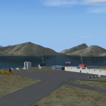
This scenery for FS-2004 as much as possible represents Saglek (CYSV), located at the north of New Foundland, Canada according to photographs found on the Web. This scenery is compatible with Mesh de M.Gilles Gauthier. Several originators took part in the design of this scenery: Regis Dassylva, Gerald Allaire, Gilles Gauthier and Jean-Pierre Fillion, all members of Concepteurs Virtual du Quebec.
| Filename: | CYSV_Canada_New_Foundland_Saglek.zip |
| License: | Freeware |
| Added: | 31st December 2009, 04:53:29 |
| Downloads: | 656 |
| Author: | Regis Dassylva |
| Size: | 2.33 MB |
| Category: Flight Simulator 2004 - Scenery | |
| Quebec sceneries Enhancements Update |
|
File Description:
Enhanced sceneries and mesh update of the province of Quebec, Canada. Must be used with
Scenes_du_Quebec_2k4.zip and qc09_2K4a.zip, qc09_2K4b.zip, qc09_2K4c.zip,
qc09_2K4d.zip files (AVSIM files library).Installation procedure in INSTALLATION_SETUP.txt.
Mise � jour et nouvelles sc�¨nes de la province de Qu�©bec. Pour utiliser cette mise � jour, il faut obligatoirement avoir d�©j� install�© les sc�¨nes du Qu�©bec contenues dans Scenes_du_Quebec_2k4.zip (sur AVSIM). Inclus aussi une mise � jour des �©l�©vations de terrain (mesh - lod09) de la province de Qu�©bec (qc09_2K4a.zip, qc09_2K4b.zip, qc09_2K4c.zip, qc09_2K4d.zip sur AVSIM). L'installation des fichiers est d�©crite dans INSTALLATION_SETUP.txt.
| Filename: | Quebec_sceneries_Enhancements_Update.zip |
| License: | Freeware, limited distribution |
| Added: | 1st November 2009, 06:49:03 |
| Downloads: | 4,759 |
| Author: | Gilles Gauthier |
| Size: | 6.81 MB |
| Category: Flight Simulator 2004 - Scenery | |
| New Terrain Mesh of the Province of Quebec in LOD09 (1/4) |
|
File Description:
The files in this package contain terrain mesh files of the province of Quebec (N45 to N53) to be used with my Quebec enhanced sceneries for FS2004 (Scenes_du_Quebec_2k4.zip). The public data sources are the Shuttle Radar Topography Mission (SRTM-3, 90m) and the Canadian Digital Elevation Data (CDED - 0.75s/arc - 23m). (QC09_2k4a.zip to QC09_2k4d.zip - 4 parts)
***********************
Les fichiers de ces archives contiennent les donnees d'elevation de terrain (mesh files - lod09), pour FS2004, du territoire de la province de Quebec sous le 53ieme degre de latitude nord. Ils ont ete crees pour etre utilises avec mes nouvelles scenes du Quebec contenues dans Scenes_du_Quebec_2k4.zip. Les donnees sources sont du domaine public et proviennent de la Shuttle Radar Topography Mission (SRTM-3, 90m) et des donnees numerique d'elevation du Canada (DNEC - 0.75s/arc -23 m). (QC09_2k4a.zip to QC09_2k4d.zip - 4 parties)
| Filename: | New_Terrain_Mesh_of_the_Province_of_Quebec_in_LOD09_14.zip |
| License: | Freeware, limited distribution |
| Added: | 27th January 2010, 18:10:18 |
| Downloads: | 8,915 |
| Author: | Gilles Gauthier |
| Size: | 23.76 MB |
| Category: Flight Simulator 2004 - Scenery | |
| New Terrain Mesh of the Province of Quebec in LOD09 (2/4) |
|
File Description:
The files in this package contain terrain mesh files of the province of Quebec (N45 to N53) to be used with my Quebec enhanced sceneries for FS2004 (Scenes_du_Quebec_2k4.zip). The public data sources are the Shuttle Radar Topography Mission (SRTM-3, 90m) and the Canadian Digital Elevation Data (CDED - 0.75s/arc - 23m). (QC09_2k4a.zip to QC09_2k4d.zip - 4 parts)
***********************
Les fichiers de ces archives contiennent les donnees d'elevation de terrain (mesh files - lod09), pour FS2004, du territoire de la province de Quebec sous le 53ieme degre de latitude nord. Ils ont ete crees pour etre utilises avec mes nouvelles scenes du Quebec contenues dans Scenes_du_Quebec_2k4.zip. Les donnees sources sont du domaine public et proviennent de la Shuttle Radar Topography Mission (SRTM-3, 90m) et des donnees numerique d'elevation du Canada (DNEC - 0.75s/arc -23 m). (QC09_2k4a.zip to QC09_2k4d.zip - 4 parties)
| Filename: | New_Terrain_Mesh_of_the_Province_of_Quebec_in_LOD0.zip |
| License: | Freeware, limited distribution |
| Added: | 1st November 2009, 06:47:09 |
| Downloads: | 4,627 |
| Author: | Gilles Gauthier |
| Size: | 27.78 MB |
| Category: Flight Simulator 2004 - Scenery | |
| New Terrain Mesh of the Province of Quebec in LOD09 (3/4) |
|
File Description:
The files in this package contain terrain mesh files of the province of Quebec (N45 to N53) to be used with my Quebec enhanced sceneries for FS2004 (Scenes_du_Quebec_2k4.zip). The public data sources are the Shuttle Radar Topography Mission (SRTM-3, 90m) and the Canadian Digital Elevation Data (CDED - 0.75s/arc - 23m). (QC09_2k4a.zip to QC09_2k4d.zip - 4 parts)
***********************
Les fichiers de ces archives contiennent les donnees d'elevation de terrain (mesh files - lod09), pour FS2004, du territoire de la province de Quebec sous le 53ieme degre de latitude nord. Ils ont ete crees pour etre utilises avec mes nouvelles scenes du Quebec contenues dans Scenes_du_Quebec_2k4.zip. Les donnees sources sont du domaine public et proviennent de la Shuttle Radar Topography Mission (SRTM-3, 90m) et des donnees numerique d'elevation du Canada (DNEC - 0.75s/arc -23 m). (QC09_2k4a.zip to QC09_2k4d.zip - 4 parties)
| Filename: | New_Terrain_Mesh_of_the_Province_of_Quebec_in_LOD0.zip |
| License: | Freeware, limited distribution |
| Added: | 27th January 2010, 18:15:12 |
| Downloads: | 7,495 |
| Author: | Gilles Gauthier |
| Size: | 29.35 MB |
© 2001-2026 AVSIM Online
All Rights Reserved
Privacy Policy |