
Where Flight Simulation Enthusiasts Gather from Around the World!
AVSIM Library - Search Results

| Category: Flight Simulator 2004 - Scenery | |
| Hells Canyon, Oregon / Idaho SRTM30_1ArcSec Terrain Mesh |

|
File Description:
This 38m terrain mesh is centered in Hells Canyon of the Snake River
between Oregon and Idaho. Coverage area: From West 116.2° to West 117.1°
and North 45.0° to North 46.5°. It includes the City of Lewiston,
Hells Canyon National Recreation Area with Snake and Imnaha River,
Salmon River and the Seven Devils mountain peaks.
| Filename: | Hells_Canyon_Oregon__Idaho_SRTM30_1ArcSec_Terrain_.zip |
| License: | Freeware, limited distribution |
| Added: | 29th December 2003, 16:58:59 |
| Downloads: | 3,025 |
| Author: | Andreas Trawny |
| Size: | 6.16 MB |
| Category: Flight Simulator 2004 - Scenery | |
| Organ Pipe Cactus National Monument, Arizona |
|
File Description:
USGS SRTM30 1 arc-second, resampled to LOD10 (38.2 meters). This terrain mesh is centered at Organ Pipe Cactus National Monument
in southern Arizona, bordering to Mexico. Coverage area: From West 112.4° to
West 113.3° and North 31.8° to North 32.6°. It includes the National Monument,
the Town of Ajo and surrounding mountains.
| Filename: | Organ_Pipe_Cactus_National_Monument_Arizona.zip |
| License: | Freeware, limited distribution |
| Added: | 2nd January 2004, 18:01:32 |
| Downloads: | 1,917 |
| Author: | Andreas Trawny |
| Size: | 2.24 MB |
| Category: Flight Simulator 2004 - Scenery | |
| Joshua Tree + San Bernardino Mountains, California 38m Terrain Mesh |
|
File Description:
USGS SRTM30 1 arc-second, resampled to LOD10 (38.2 meters). This terrain mesh is centered at Joshua Tree National Park in southern California. Coverage area: From West 115.1° to West 117.4° and North 33.7° to North 34.3°. It includes the National Park, the Palm Springs area with Mount San Jacinto and the San Bernardino Mountains.
| Filename: | Joshua_Tree__San_Bernardino_Mountains_California_3.zip |
| License: | Freeware, limited distribution |
| Added: | 4th January 2004, 21:05:58 |
| Downloads: | 3,714 |
| Author: | Andreas Trawny |
| Size: | 4.57 MB |
| Category: Flight Simulator 2004 - Scenery | |
| Canada - British Columbia - Bowron Lake Prov.Park Scenery Update v1.1 |
|
File Description:
Updates V1.0 to v1.1 by adding waterfalls and river rapids in the Cariboo and Isaac Rivers and adds a landclass fix. Designed to compliment UT Canada/Alaska and FSGenesis Cordillera or other 38.2 meter mesh (LOD10) such as Raimondo Taburet freeware mesh for BC. Patches for UT Canada have yet to repair this areas rivers. Located in central BC, Bowron Lake is a world famous canoeing circuit. This scenery fixes two major sections of the Cariboo River that are missing from UT Canada. Includes scenery files, effects, park documents and screenshots.
| Filename: | Canada__British_Columbia__Bowron_Lake_ProvPark_Sce.zip |
| License: | Freeware, limited distribution |
| Added: | 12th October 2005, 09:12:13 |
| Downloads: | 1,866 |
| Author: | Bryan Wallis |
| Size: | 7.91 MB |
| Category: Flight Simulator 2004 - Scenery | |
| ALTAM Intersection Scenery Enhancements |
|
File Description:
This scenry project adds missing lake under the ALTAM intersection near Livermore CA, as well as some of the major roads and golf courses in the area. This improves the VFR flying from the extreamly boring default FS rendition. This project was built to be used with the freeware LOD10(38-m) mesh from Justin Tyme at FSGeneis.com.
I have included my LWM source file for Ground2K4 (Christian Fumey) for your further editing if desired.
| Filename: | ALTAM_Intersection_Scenery_Enhancements.zip |
| License: | Freeware, limited distribution |
| Added: | 11th May 2004, 12:42:19 |
| Downloads: | 1,443 |
| Author: | Karl Hannestad |
| Size: | 2.17 MB |
| Category: Flight Simulator 2004 - Scenery | |
| Glen Canyon / Lake Powell, Utah 38m Terrain Mesh |
|
File Description:
USGS SRTM30 1 arc-second, resampled to LOD10 (38.2 meters).
This high-resolution terrain mesh is centered at Glen Canyon
National Recreation Area in south-eastern Utah. Coverage area:
From West -111.6° to West -110.2° and North 36.8° to North 38.0°.
It includes the National Recreation Area with Lake Powell,
Navajo Mountain, the Henry Mountains, parts of Capitol Reef
National Park / Grand Staircase Escalante National Monument,
the town of Page in northern Arizona and surrounding areas.
| Filename: | Glen_Canyon__Lake_Powell_Utah_38m_Terrain_Mesh.zip |
| License: | Freeware, limited distribution |
| Added: | 25th January 2004, 20:30:45 |
| Downloads: | 5,417 |
| Author: | Andreas Trawny |
| Size: | 8.31 MB |
| Category: Flight Simulator 2004 - Scenery | |
| California Central Coast Scenery CCCoastF revised 12/18/04 |
|
Images related to this file:
File Description:
This is a complete and revised version of CCCOASTM.ZIP that was released on 3/31/04 and includes all subsequent revisions to CCCOASTM. It is compatible with and requires 38.2m LOD10 mesh terrain and has been tweaked to work better with, but doesn't require, USA Roads. Many other fixes, additions and improvements.
Note: This is a re-upload of the file originally uploaded on December 18th 2004 that was corrupted by the Avsim Library hack.
| Filename: | California_Central_Coast_Scenery_CCCoastF_revised_.zip |
| License: | Freeware |
| Added: | 28th May 2010, 19:54:02 |
| Downloads: | 4,175 |
| Author: | Al Wheeler |
| Size: | 5.66 MB |
| Category: Flight Simulator 2004 - Scenery | |
| Bella Coola Valley Terrain Mesh and Scenery Enhancements |
|
File Description:
One of the most spectacular watersheds of British Columbia's Midcoast, the Bella Coola Valley looks pretty boring in its default FS rendition. These files provide a LOD10 (38-m) mesh made from CDED1 0.75-arcsec data, a new landclass file, and accurate placements of lakes, rivers, streams, and roads. Also includes the glaciers of the Monarch Mt. Icefield and several forestry roads and clearcuts along the side valleys. Made with Ground2K4 based on Landsat 7 ETM+ satellite imagery.
| Filename: | Bella_Coola_Valley_Terrain_Mesh_and_Scenery_Enhanc.zip |
| License: | Freeware, limited distribution |
| Added: | 1st April 2004, 20:49:32 |
| Downloads: | 8,867 |
| Author: | Holger Sandmann |
| Size: | 20.74 MB |
| Category: Flight Simulator 2004 - Scenery | |
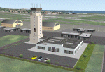
| Dragon Peaks AFB, South Africa |
|
Images related to this file:
File Description:
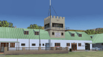
A Gmax representation of Dragon Peaks Air Force Base also referred to as CL van Wyngaard Airfield, South Africa with photoreal textures.
AFB Dragon Peaks is a small airfield nestled between the hills on the slopes of the Northern Drakensberg of South Africa. The airfield is situated only a few hundred meters from the Dragon Peaks Mountain resort as well as the home of the famous Drakensberg Boys Choir.
The grass runway is aligned 06/24 and 458m long and sits at an elevation of 3 986ft.
The scenery consists of 64 square kilometers of photoscenery with variants for all 4 seasons. Almost 1 100 hand placed autogen buildings and more than 32 000 (yes, thirty-two-thousand) hand placed autogen trees makes up the surrounding scenery. At the airfield itself you will find custom made Gmax models of the airfield buildings and structures with photoreal textures.
| Filename: | Dragon_Peaks_AFB_South_Africa.zip |
| License: | Freeware, limited distribution |
| Added: | 9th November 2017, 18:36:39 |
| Downloads: | 462 |
| Author: | kobus van wyk |
| Size: | 19.94 MB |
| Category: Flight Simulator 2004 - Aircraft Repaints, Textures and Modifications | |
| Tibet Airlines Airbus A319 (B-6437) |
|
Images related to this file:
File Description:
Airbus A319 B-6437 of Tibet Airlines, equipped with CFM engines, very nice for the Himalayan air travel. In order to make this repaint work right, you have to install Project Airbus A319 first.
| Filename: | Tibet_Airlines_Airbus_A319_B6437.zip |
| License: | Freeware, limited distribution |
| Added: | 1st March 2012, 16:13:25 |
| Downloads: | 421 |
| Author: | Alex Chao, Project Airbus |
| Size: | 15.07 MB |
© 2001-2026 AVSIM Online
All Rights Reserved
Privacy Policy |