
Where Flight Simulation Enthusiasts Gather from Around the World!
AVSIM Library - Search Results

| Category: Flight Simulator 2004 - Scenery | |
| Pennsylvania 30 meter Mesh Scenery Fix |

|
File Description:
Pennsylvania 30 meter Mesh Scenery Fix. Replacement pamesh3.bgl from "pa_30m_mesh2_8.zip". Removes the three erroneous mountain peaks from the area near Pittsburgh. Note: If you downloaded the revised pa_30m_mesh2_8.zip, you will not need this download.
| Filename: | Pennsylvania_30_meter_Mesh_Scenery_Fix.zip |
| License: | Freeware |
| Added: | 14th December 2003, 23:27:58 |
| Downloads: | 2,113 |
| Author: | Phil Cruikshank |
| Size: | 1.54 MB |
| Category: Flight Simulator 2004 - Scenery | |
| Alps LOD10 Topo Mesh - Switzerland and France |
|
Images related to this file:
File Description:
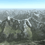
Yet another terrain mesh package of the European Alps? Well, this one is different in that it is NOT primarily based on the Shuttle Radar (SRTM) data with their incomplete coverage of prominent peaks and ridges. Instead, most of the source data for this project were developed over many months by Jonathan de Ferranti using detailed topographic maps. While Jonathan's work is unrelated to flight simulation he kindly gave me permission to compile his data for use in FS. The result is a wonderful improvement in detail and accuracy over any existing SRTM- or DTED-based mesh file, freeware or commercial (a link to an extensive set of screenshot comparisons is included in the read-me file).
I've compiled the source data at LOD10 (38-m) grid resolution because the coverage area is smaller than most existing mesh files. Thus, anyone can use these files without having to first uninstall their current mesh set. Also included are LOD9 and LO8 buffer mesh files. Note: if you own Switzerland Professional with its high-resolution terrain mesh then you don't need this package, at least not the Switzerland files!
| Filename: | Alps_LOD10_Topo_Mesh__Switzerland_and_France.zip |
| License: | Freeware, limited distribution |
| Added: | 30th May 2010, 09:51:03 |
| Downloads: | 58,986 |
| Author: | Holger Sandmann, Jonathan de Ferranti |
| Size: | 50.03 MB |
| Category: Flight Simulator 2004 - Scenery | |
| Alps LOD10 Topo Mesh - Austria and Italy |
|
Images related to this file:
File Description:
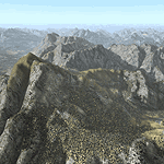
Yet another terrain mesh package of the European Alps? Well, this one is different in that it is NOT primarily based on the Shuttle Radar (SRTM) data with their incomplete coverage of prominent peaks and ridges. Instead, most of the source data for this project were developed over many months by Jonathan de Ferranti using detailed topographic maps. While Jonathan's work is unrelated to flight simulation he kindly gave me permission to compile his data for use in FS. The result is a wonderful improvement in detail and accuracy over any existing SRTM- or DTED-based mesh file, freeware or commercial (a link to an extensive set of screenshot comparisons is included in the read-me file).
I've compiled the source data at LOD10 (38-m) grid resolution because the coverage area is smaller than most existing mesh files. Thus, anyone can use these files without having to first uninstall their current mesh set. Also included are LOD9 and LO8 buffer mesh files. Note: if you own Austria Professional 2004 with its 1:50,000 scale terrain mesh then you don't need this package!
| Filename: | Alps_LOD10_Topo_Mesh__Austria_and_Italy.zip |
| License: | Freeware, limited distribution |
| Added: | 30th May 2010, 09:46:58 |
| Downloads: | 62,947 |
| Author: | Holger Sandmann, Jonathan de Ferranti |
| Size: | 73.32 MB |
| Category: Flight Simulator 2004 - Scenery | |
| US North Cascades Mountains and Northwest Washington Coast |
|
File Description:
The files in this package completely replace the FS default landscape of the North Cascades Mountains and coastal areas of northwestern Washington State. Between Bellingham and Arlington (N-S), Orcas Island and Lake Chelan (W-E) you can now enjoy your VFR flights with accurate locations of coastlines, lakes, rivers, streams, roads, railroads, and power lines, as well as land use type (landclass) and terrain (add-on mesh). Also added are the larger glaciers of the majestic North Cascades volcanoes and peaks as well as several forestry roads and clearcuts outside the National Park and Wilderness areas. Made mostly with Christian Fumey's "Ground2K4" and Jim Keir's "Slartibartfast". Fully compatible with the recent freeware LOD10 add-on meshes of the western US. Mesh and landclass files will work in FS2002 but not the special scenery enhancements.
| Filename: | US_North_Cascades_Mountains_and_Northwest_Washingt.zip |
| License: | Freeware, limited distribution |
| Added: | 18th May 2004, 23:12:57 |
| Downloads: | 14,319 |
| Author: | Holger Sandmann |
| Size: | 12.72 MB |
| Category: Flight Simulator 2004 - Scenery | |
| Appalachian Mountains, Virginia / West Virginia |
|
File Description:
USGS SRTM30 1 arc-second, resampled to LOD10 (38.2 meters).
This high-resolution terrain mesh is centered in the Appalachian Mountains
between Virginia and West Virginia. Coverage area: From West -81° to West -79°
and North 37° to North 39°.
| Filename: | Appalachian_Mountains_Virginia__West_Virginia.zip |
| License: | Freeware, limited distribution |
| Added: | 10th January 2004, 18:06:59 |
| Downloads: | 3,678 |
| Author: | Andreas Trawny |
| Size: | 17.1 MB |
| Category: Flight Simulator 2004 - Scenery | |
| Guadalupe Mountains National Park SRTM30_1ArcSec Terrain Mesh |
|
File Description:
USGS SRTM30 1 arc-second, resampled to LOD10 (38.2 meters).
This terrain mesh is centered in western Texas panhandle.
Coverage area: From West 104° to West 106° and North 31° to North 32°.
It includes Guadalupe Mountains National Park and its surrounding areas.
| Filename: | Guadalupe_Mountains_National_Park_SRTM30_1ArcSec_T.zip |
| License: | Freeware, limited distribution |
| Added: | 27th December 2003, 19:07:04 |
| Downloads: | 1,294 |
| Author: | Andreas Trawny |
| Size: | 7 MB |
| Category: Flight Simulator 2004 - Scenery | |
| Pennsylvania 30 meter Mesh Scenery Revision |
|
File Description:
Pennsylvania 30 meter Mesh Scenery revision. "pamesh3.bgl" was replaced from "pa_30m_mesh2_8.zip". Removes the three erroneous mountain peaks from the area near Pittsburgh. Note: This download is a replacement for the original "pa_30m_mesh2_8.zip". If yo downloaded the original and the fix, you don't need this file.
| Filename: | Pennsylvania_30_meter_Mesh_Scenery_Revision.zip |
| License: | Freeware |
| Added: | 14th December 2003, 23:34:24 |
| Downloads: | 2,302 |
| Author: | Phil Cruikshank |
| Size: | 4.95 MB |
| Category: Flight Simulator 2004 - Scenery | |
| LOD10 (38-m) Glacier Bay National Park, Alaska |
|
File Description:
This LOD10 (38-m) add-on mesh of Glacier Bay National Park and the adjacent Lynn Canal area between Juneau and Skagway (N58-60 W134-138) is an optional (!) upgrade of gl_bay_1.zip (by Holger Sandmann and Jim Keir). It adds more detail to the mountainous areas and allows to locally override other installed Alaska add-on meshes without having to deactivate them. The USGS NED seamless digital elevation data used for this mesh have a 2-arcsec (~60-m) resolution. Thus, the compilation as LOD10 (38-m) will reveal all terrain details contained in the source data. Please read the gl_bay_1.zip read-me file for further information about the special features of the Glacier Bay Project.
| Filename: | LOD10_38m_Glacier_Bay_National_Park_Alaska.zip |
| License: | Freeware, limited distribution |
| Added: | 16th February 2004, 03:40:57 |
| Downloads: | 8,593 |
| Author: | Holger Sandmann |
| Size: | 24.98 MB |
| Category: Flight Simulator 2004 - Scenery | |
| Airports of Nepal 2.1 |
|
File Description:
This is an update to make Einar Aarvik's Nepal scenery 2.0 compatible with the new LOD 10 mesh uploaded by Holger Sandmann. Includes new Taplejung airport. By Einar Aarvik.
Also includes fictional glacier strips and fictional and invisible helipads for the Everest and K2 peaks. By Halfdan Abrahamsen, who also uploaded these files.
| Filename: | Airports_of_Nepal_21.zip |
| License: | Freeware |
| Added: | 2nd March 2006, 01:40:05 |
| Downloads: | 16,650 |
| Author: | Einar Aarvik/Halfdan Abrahamsen |
| Size: | 204.02 KB |
| Category: Flight Simulator 2004 - Scenery | |
| Canada - British Columbia - Bowron Lake Provincial Park Scenery Enhancements v1.0 |
|
File Description:
Designed to compliment Ultimate Terrian Canada/Alaska and FSGenesis Cordillera or other 38.4 meter mesh (LOD10) such as Raimondo Taburet freeware mesh for BC. Patches for UT Canada have yet to repair rivers in this area. Located in Central BC, Bowron Lake is a world famous canoeing circuit. This scenery fixes two major sections of the Cariboo River that are missing from UT Canada. Includes scenery files, park documents & map and screenshots.
| Filename: | Canada__British_Columbia__Bowron_Lake_Provincial_P.zip |
| License: | Freeware, limited distribution |
| Added: | 10th October 2005, 11:46:15 |
| Downloads: | 1,377 |
| Author: | Bryan Wallis |
| Size: | 6.53 MB |
© 2001-2026 AVSIM Online
All Rights Reserved
Privacy Policy |