
Where Flight Simulation Enthusiasts Gather from Around the World!
AVSIM Library - Search Results

| Category: Flight Simulator 2004 - Scenery | |
| KCMH - John Glenn Columbus International Airport - Ohio, USA ** UPDATED ** |

|
File Description:
I have updated more details with flags, people, dirty parking spots, numbers/letters signs. A few corrections links or others. The airport had been changed named just recently now is John Glenn Columbus International Airport, Ohio, USA.
| Filename: | KCMH__John_Glenn_Columbus_International_Airport___.zip |
| License: | Freeware |
| Added: | 30th June 2016, 09:34:53 |
| Downloads: | 306 |
| Author: | Stuart J Gilbert II |
| Size: | 992.71 KB |
| Category: Flight Simulator 2004 - Gauges | |
| Tri Altitude Gauge Info update |
|
File Description:
FS2004 Tri-Altitude Gauge update. These revised instructions will correct the mistake in the Info.txt instruction file for this gauge. The incorrect instruction prevents the gauge from appearing in the aircraft panel. Glenn Copeland
| Filename: | Tri_Altitude_Gauge_Info_update.zip |
| License: | Freeware |
| Added: | 7th December 2005, 23:01:19 |
| Downloads: | 1,335 |
| Author: | Glenn Copeland |
| Size: | 1.03 KB |
| Category: Flight Simulator 2004 - Panels | |
| Boeing 747-400 |
|
File Description:
Panel for the Boeing 747-400 featuring some gauges from Ken Mitchell and Glenn Copeland.
Works with the default 747 and the Boeing 747-400 from Project Opensky ( Posky ).
Only testet at 1280x1024.
Virtual Cockpit layout not changed.
| Filename: | Boeing_747400.zip |
| License: | Freeware |
| Added: | 1st October 2006, 18:50:53 |
| Downloads: | 14,809 |
| Author: | Thomas Meier |
| Size: | 4.6 MB |
| Category: Flight Simulator 2004 - Scenery | |
| Page (KPGA), Lake Powell West, Utah/Arizona, Photo-Scenery (FS9 & FSX) |
|
Images related to this file:
File Description:
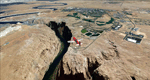
This scenery covers the western part of Lake Powell, the city of Page (KPGA), the Vermillion Cliffs, Glenn Canyon just south of Glenn Canyon Dam, the northern part of Marble Canyon, Paria Canyon, Cockscomb, etc, etc. Spectacular! To explore the scenery depart from Page Municipal Airport (KPGA). High resolution versions of this scenery for FS9 and FSX (much sharper, but larger and multiple downloads) are available at www.blueskyscenery.com/CNY_South3West3.html . The screenies are taken from the high-res versions, so expect this version to be slightly more blurry. YourDonation@Work: Dedicated to William, Veit and Michele.
| Filename: | Page_KPGA_Lake_Powell_West_UtahArizona_PhotoScener.zip |
| License: | Freeware, limited distribution |
| Added: | 3rd March 2010, 21:26:32 |
| Downloads: | 1,818 |
| Author: | Gottfried Razek - blueskyscenery.com |
| Size: | 92.41 MB |
| Category: Flight Simulator 2004 - Aircraft Repaints, Textures and Modifications | |
| F-86F Sabre "MiG Mad Marine" |
|
File Description:
US Air Force F-86F-30 Sabre "MiG Mad Marine". A repaint with extra supplementary texture detailing for the FS2004 SECTIONF8 North-American F-86EF Saber (SF86EF.ZIP). This is a representation of the airplane flown by Maj. John H. Glenn, Jr., USMC while TDY as an exchange pilot with the USAF during the Korean War. The art work on the side of the fuselage was unusual since it referred not only to Maj. Glenn, but also to his family by the addition of the label, "Lyn - Annie - Dave I" forward of the primary art. Like most combat aircraft, the art appeared only on the left side. Textures by Cliff Presley.
| Filename: | F86F_Sabre_MiG_Mad_Marine.zip |
| License: | Freeware |
| Added: | 8th November 2008, 14:42:42 |
| Downloads: | 1,775 |
| Author: | Cliff Presley |
| Size: | 4.36 MB |
| Category: Flight Simulator 2004 - Panels | |
| Modified Feelthere´s PIC Boeing 737 |
|
File Description:
A modification for the PIC B737-300/400/500 FeelThere panels. Enlarged some windows to make them easier to read and work with. Added Rob Barendregt´s groundhandling gauge, Glenn Copeland´s call sign nameplate, etc. Requires a licensed version of FeelThere´s PIC B737 installed in your hard drive
| Filename: | Modified_Feeltheres_PIC_Boeing_737.zip |
| License: | Freeware |
| Added: | 15th February 2006, 03:58:59 |
| Downloads: | 5,484 |
| Author: | Edmundo Azevedo |
| Size: | 545.98 KB |
| Category: Flight Simulator 2004 - Scenery | |
| Wilgrove Airpark (8A6) |
|
Images related to this file:
File Description:
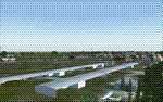
Wilgrove Airpark (8A6) is a small GA airport located just east of Charlotte, NC. It is often forgotten by pilots in Flightsimulator, yet it is a very busy place in the real-world, due to it's huge popularity with student and weekend GA pilots. There has never been a really good, accurate representation of this little gem created for the flightsim, so I decided to try my hand at it. This is my very first scenery project, and I hope you enjoy it. It was designed with ADE9X, and it requires RWY12 and EZ-Scenery objects extensively,(not included) so you will need to download these freeware scenery libraries prior to installation of this package for the Wilgrove Airpark scenery to display properly. - Glenn Mullis
| Filename: | Wilgrove_Airpark_8A6.zip |
| License: | Freeware, limited distribution |
| Added: | 22nd September 2010, 16:59:32 |
| Downloads: | 278 |
| Author: | Glenn Mullis |
| Size: | 4.4 MB |
| Category: Flight Simulator 2004 - Scenery | |
| Fout's Airpark (5TN2) |
|
File Description:
This is a little airport in East Tn. It is in Jefferson County. By interstate 40 and Dougles Lake. It has a place to land on the lake too. Hope you enjoy. It also has a FSE file in it
| Filename: | Fouts__Airpark__5TN2.zip |
| License: | Freeware |
| Added: | 28th February 2004, 00:12:42 |
| Downloads: | 606 |
| Author: | Glenn Fout |
| Size: | 3.33 MB |
| Category: Flight Simulator 2004 - Panels | |
| F16 |
|
File Description:
FS2004 Panel, F16 Air Show Tour. The panel of this jet fighter has been designed for cross country flying to events worldwide. The 2D cockpit is packed with new gauges that complement this high performance, yet docile aircraft. All gauges, lights, etc. are functional, easy to read, and are panel installed except GPS 500. For long distance flights, the panel contains on-demand refueling capabilities for both ground and air operations. A few of the new gauges are; 180-degree scan navigational radar, triple mode interceptor-refueling-terrain radar, refueling gauge with command screen, fuel center with time/distance remaining computer, new Descentometer for Mach-plus aircraft, analog engine gauges including thrust and fuel efficiency, plus a hangar full of warning and indicator lights. The intercept mode of the ai-radar feeds info to the autopilot to assist in the rendezvous with tanker to allow all-weather, day or night air refueling. Digital data for AP, radio, altimeter, timer, and Descentometer is input via a central keypad. Acknowledge ATC instructions using joystick. Designed for use with Kirk Olsson's F16 Viper. Includes 15 page illustrated instructions plus Intercept and Refueling tutorial. By Glenn Copeland
| Filename: | F16.zip |
| License: | Freeware |
| Added: | 12th January 2007, 03:00:43 |
| Downloads: | 5,780 |
| Author: | Glenn Copeland |
| Size: | 1.83 MB |
| Category: Flight Simulator 2004 - Scenery | |
| Woodward Field Airport KCDN |
|
Images related to this file:
File Description:
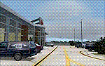
Woodward Field Airport is a county-owned public-use general aviation airport. It is sometimes called Kershaw County Airport, and many people also know it as the Camden Airport. It is located approx. 6.9 miles northeast of the historical city of Camden, South Carolina and currently does not serve scheduled airline flights. It is host to several vintage aircraft events and fly-in's annually. Scenery was designed with ADE9X v1.47 and Google Maps.(for placement references) Requires EZ-Scenery and RWY12 library collections for proper display of scenery objects. ez_1.zip and rwy12_1.zip
| Filename: | Woodward_Field_Airport_KCDN.zip |
| License: | Freeware |
| Added: | 20th November 2011, 00:02:58 |
| Downloads: | 482 |
| Author: | Glenn Mullis |
| Size: | 3.22 MB |
© 2001-2026 AVSIM Online
All Rights Reserved
Privacy Policy |