
Where Flight Simulation Enthusiasts Gather from Around the World!
AVSIM Library - Search Results

| Category: Flight Simulator 2004 - AI Aircraft | |
| Delta Airlines McDonnell Douglas DC-9-30 New Colors |

|
File Description:
Repaint of the AI Aardvark Douglas Corporation DC-9-50 in Delta Air Lines new color scheme. Paint made on an enhanced paintkit from Billy Rutherford. Base files package for FS2004 (aiafs9up.zip) available here at Avsim. This is an AI only aircraft.
| Filename: | Delta_Airlines_McDonnell_Douglas_DC930_New_Colors.zip |
| License: | Freeware |
| Added: | 18th December 2008, 22:48:59 |
| Downloads: | 1,723 |
| Author: | Juergen Baumbusch |
| Size: | 1.01 MB |
| Category: Flight Simulator 2004 - AI Aircraft | |
| EasyJet Airbus A320 NEO |
|
Images related to this file:
File Description:
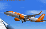
The repaint of easyJet A320-251N for FAIB_A320S_CFML model.Included two liveries (standard & with NEO logo).
This is only for FS2004(FS9.1).
Textures only,requires the base model,which is available at fsxaibureau.com.
Format is DXT3/No Mipmaps,includes the optional 32 bit texture.
| Filename: | EasyJet_Airbus_A320_NEO.zip |
| License: | Freeware |
| Added: | 22nd March 2019, 22:52:20 |
| Downloads: | 625 |
| Author: | Fumitaka Hayashi |
| Size: | 1.95 MB |
| Category: Flight Simulator 2004 - AI Aircraft | |
| Forca Aerea Brasileira Hawker 800XP / BAe HS-125-800 |
|
File Description:
A repaint of Henry Tomkiewicz' AI Hawker 800XP / BAe HS-125-800, in Forca Aerea Brasileira (Brazilian Air Force) livery, based on recent photos of actual aircraft. Textures only, based on the paintkit by Henry Tomkiewicz. Model available seperatly here at AVSIM.
| Filename: | Forca_Aerea_Brasileira_Hawker_800XP__BAe_HS125800.zip |
| License: | Freeware |
| Added: | 24th October 2005, 03:49:57 |
| Downloads: | 828 |
| Author: | John Bridgham, Henry Tomkiewicz |
| Size: | 113.26 KB |
| Category: Flight Simulator 2004 - Aircraft Repaints, Textures and Modifications | |
| Santa Barbara Airlines Aerospatiale ATR 42-320 (YV1423) |
|
File Description:
Santa Barbara Airlines Aerospatiale ATR 42-320, registration YV1423, showing the new livery used by this airline. Textures for the ISDT (Israeli Simulation Design Team) ATR 42-300 v2 model. Look for details at www.isdt-israel.com. Textures only!
By Juan Ernesto Oropeza
| Filename: | Santa_Barbara_Airlines_Aerospatiale_ATR_42320_YV14.zip |
| License: | Freeware |
| Added: | 27th March 2009, 01:59:30 |
| Downloads: | 318 |
| Author: | Juan Ernesto Oropeza |
| Size: | 1.78 MB |
| Category: Flight Simulator 2004 - Scenery | |
| Dusseldorf International 'EDDL' v1 |
|
Images related to this file:
File Description:
Dusseldorf International Airport 'EDDL' is the third largest airport in Germany. This scenery is the first release (v1.0) of my work. Scenery includes all three terminals and the LTU hangar. This version also includes a complete AGNIS Docking system at the terminals.
| Filename: | Dusseldorf__International_EDDL_v1.zip |
| License: | Freeware |
| Added: | 15th May 2010, 09:35:28 |
| Downloads: | 29,989 |
| Author: | Daniel Schmidt-Stiebitz |
| Size: | 4.44 MB |
| Category: Flight Simulator 2004 - AI Flight Plans | |
| Air Alliance (Georgian Airlines) Winter 2005/06 |
|
File Description:
Winter 2005/06 AI flightplans for Air Alliance (Georgian Airlines). Operating a fleet of 16 B1900D's on regional Canadian and trans-border US routes with main hubs at Toronto, Montreal and Halifax.100% accurate, all routes included and 100% PAX aircraft utilisation.
| Filename: | Air_Alliance_Georgian_Airlines_Winter_200506.zip |
| License: | Freeware, limited distribution |
| Added: | 20th February 2006, 20:29:49 |
| Downloads: | 1,054 |
| Author: | Garry Lewis |
| Size: | 6.2 KB |
| Category: Flight Simulator 2004 - Scenery | |
| Whati CEM3 in the Northwest Territories, Canada |
|
Images related to this file:
File Description:
Whati is a village at the southern end of Lac La Martre, a smaller lake (only by Canadian standards, at over 40 miles long) halfway between the Great Slave Lake and the Great Bear Lake and around 100 miles north of Yellowknife. The North West Company established a trading post there in 1793, and this was the centre for local trading in the area for 100 years until a post was opened by the Hudson Bay Company on the Great Slave Lake. The current population is in the region of 520. There is no graded road access and access is by boat or air. The main local economy revolves around hunting and fishing, with efforts being made to increase tourism amid the wilderness and the wildlife. The airfield is just over a mile east of the village, with a runway of around 3,400 feet of gravel aligned 09-27 as of 2010, with PAPI at both ends and lit. There are scheduled flights from Yellowknife by Air Tindi, included in the AI, and some GA. The terminal building is similar to that of Lutselk'e, but with a different colour scheme and with solar panels on the roof. It appears that they repaint the sign on the front of the building with a different wording every time; the one I have used is one of three that have existed in the last few years. The photos I had originally were taken in the winter, with snow. Seeing it in the summer I discovered that my version of the building is not at the right level above the ground by about a foot, or 30cm. I was too lazy to make it again, which was the only way to get it right and still have it throw a shadow on the ground. This scenery modifies the lake shore, corrects levels for land and lake, and adds the village and a connecting road in addition to the airport. A note here about my scenery making. There will not be many more to follow this as I am almost at the end of the photos I either took or found for scenery purposes, plus I expect to move on from FS9 at some point during next year.
| Filename: | Whati_CEM3_in_the_Northwest_Territories_Canada.zip |
| License: | Freeware, limited distribution |
| Added: | 15th December 2019, 19:18:29 |
| Downloads: | 150 |
| Author: | Roger Wensley |
| Size: | 4.25 MB |
| Category: Flight Simulator 2004 - AFCAD Files | |
| Santos Dumont (SBRJ) Rio De Janeiro |
|
File Description:
This file is a version for the default airport with extra gates/parking the runways/taxiways/aprons have improved lighting and for the heli pilots i have added a helipad which also has lighting airport views are from the roof of the control tower (only when you are in TOWER view) for those that have Lee swordy's wonderful afcad2 found here at Avsim.com can lower the tower height by 30ft you will then be inside the control tower but may find the tinted glass to dark to see clearly especially at night time (fully tested with Ultimate Traffic but not required) both runways will be used
| Filename: | Santos_Dumont_SBRJ_Rio_De_Janeiro.zip |
| License: | Freeware |
| Added: | 20th December 2003, 22:57:50 |
| Downloads: | 2,456 |
| Author: | Ray Smith |
| Size: | 5.4 KB |
| Category: Flight Simulator 2004 - AFCAD Files | |
| Christchurch Intl (NZCH) New Zealand |
|
File Description:
This file is a version for the default airport with 33 gates/parking/cargo parking and for the heli pilots i have added 3 helipads that are spread around the airport, airport views are from the roof of the control tower (only when you are in TOWER view) for those that have Lee swordy's wonderful afcad_204 found here at Avsim.com can lower the tower height by 30ft you will then be inside the control tower but may find the tinted glass to dark to see clearly especially at night time, taxiways realigned, and all taxiways now have lighting and both runways also have improved lighting.
| Filename: | Christchurch_Intl_NZCH_New_Zealand.zip |
| License: | Freeware |
| Added: | 23rd November 2003, 05:02:01 |
| Downloads: | 1,370 |
| Author: | Ray Smith |
| Size: | 5.62 KB |
| Category: Flight Simulator 2004 - Scenery | |
| World's Highest Airfield @ 16600 feet - Daulat Beg Oldie |
|
File Description:
Located at an altitude of 16600 feet in North Eastern Ladakh near the strategic Karakoram Pass, DBO is an important Indian Army post which links with the ancient Silk Route to China. The Indian army maintains a helipad and an airstrip here, which is highest in the world. It is just 8 km south the Chinese border and 9 km northwest of the Aksai Chin & line of actual control between China and India. The scenery is truly fictional as no information is available on internet regarding the orientation of airstrip. Works best with Himalayan Peaks LOD10 Mesh, Volume 6 - Jammu and Kashmir avaiable at avsim: (fs_him_06.zip)
| Filename: | Worlds_Highest_Airfield__16600_feet__Daulat_Beg_Ol.zip |
| License: | Freeware |
| Added: | 26th June 2008, 10:57:26 |
| Downloads: | 964 |
| Author: | Deepak Blassi |
| Size: | 1.3 MB |


© 2001-2026 AVSIM Online
All Rights Reserved
Privacy Policy |