
Where Flight Simulation Enthusiasts Gather from Around the World!
AVSIM Library - Search Results

| Category: Flight Simulator 2004 - Scenery | |
| CPR5 - Woodstock - Ontario, Canada |

|
Images related to this file:
File Description:
This is the first of a south Ontario series. Woodstock is a town with a population of around 38,000, located 50 miles west of Lake Ontario. The airfield is 3 miles west of the town, with a single grass runway just over 3,000 feet long and 100 plus feet wide, aligned 05/23 in FS9 (in fact it is now 06/24 due to the magnetic north wandering off during the last 10 years). There have been at different times varying amounts of gravel mixed in with the grass on both runway and taxiway; the majority surface by far is grass and I have left it all as such, as there is no visually convincing way to mix the two without unreal sharp edges. The apron is on the northern side of the runway, and is now modified in shape to maximise the area available for crops. There are 10 "T" hangars and a small clubhouse in a single long building. There is no fuel, runway lighting, or taxiway or apron lights so usage is effectively restricted to daylight hours. To the east of CPR5 and on the edge of the town is a private airstrip with 2,800 feet of asphalt runway; I have added this as a visual reference, along with several large grain silos on the other side of the road. Hidden in plain sight amid the surrounding farmland, the first sighting of CPR5 is actually always of the adjacent and far more visible buildings just to the east of the apron, which are owned by a company that deals with everything to do with boats, up to and including fishing gear. These have been included. As ditches cannot be effectively duplicated in FS9 I have included some fences which do not exist in real life, to give some needed visual clues.
| Filename: | CPR5__Woodstock__Ontario_Canada.zip |
| License: | Freeware, limited distribution |
| Added: | 8th July 2015, 13:36:05 |
| Downloads: | 184 |
| Author: | Roger Wensley |
| Size: | 5.57 MB |
| Category: Flight Simulator 2004 - Scenery | |
| Kuujjuarapik CYGW in northern Quebec, Canada |
|
Images related to this file:
File Description:
Kuujjuarapik is in northern Quebec at the southern end of Hudson Bay, 90 miles east of James Bay and on the north shore of the Great Whale River; Kuujjuarapik means Small Great River in Inuktitut. Once again the Hudson Bay trading post that opened (in 1820) was the catalyst for the establishment of first a seasonal encampment and then the beginnings of a town in the late 1930's.
The two adjacent villages that now form the town have a total population (mainly Cree and Inuit) of around 1,500. When the Quebec hydo-electric project was under construction in the early 1980's a large portion of the Inuit population voted to move to a new settlement called Umiujaq (my post) 100 miles to the north.
The airport is to the west of the town, between the town and the sea. The gravel and sand runway (which I have made as gravel as there is no convincing way to mix the two) is 5,500 feet long, 150 feet wide, and aligned 17/35, which is approximately parallel to the coast. There is fuel available, both 100LL and JetA, delivered by truck. The AI included here is for Air Inuit and Wasaya, with Air Inuit making three flights per day plus a fourth flight by the Air Inuit Twotter C-GNDO that is based at the airport, and private flights by various aircraft. Yes, there really is a golf course to the south of the airport, and the last thing to note is that Kuujjuarapik has a mandatory radio frequency and that taking into consideration the scheduled flights I have included the tower radio frequency that makes this a controlled airport in FS9.
| Filename: | Kuujjuarapik_CYGW_in_northern_Quebec_Canada.zip |
| License: | Freeware, limited distribution |
| Added: | 16th February 2013, 00:33:20 |
| Downloads: | 305 |
| Author: | Roger Wensley |
| Size: | 2.8 MB |
| Category: Flight Simulator 2004 - Scenery | |
| Tuktoyaktuk CYUB in Northwest Territories, Canada |
|
Images related to this file:
File Description:
Tuktoyaktuk is on the northern coast of Canada, 70 miles north of Inuvik and to the east of the Mackenzie River delta. It has a population of around 900 and because of its natural harbour is a centre for oil exploration activity on the surrounding land and on the Beaufort Sea, with sizeable but now under-used yards dating back to the peak of activity in the late 1970's. On land work is restricted to the winter half of the year, as only the freeze-up makes it possible to move on land with heavy equipment, and during the winter further supples are driven over an ice road from Inuvik up to Tuk. The ice-free summer months are used for floating equipment from Yuk along the coast on barges and then up the rivers to inland sites in preparation for the winter activity. Before the oil there was a DEW line station here, and there is still an automated station on the same site and included here, as are the yards. The airfield is on the coast close to the town and the yards, at 15' ASL. The gravel runway 09/27 is 5,000' feet long and 150' wide; both thresholds are displaced by 200', but of course there are no markings on the gravel. The large apron is on the north side at the centre of the runway and is large enough to accomodate several large planes. Inuvik revised should be installed first, now Tuk, then last of the three Sachs Harbour which has AI for Aklak Airlines flights (operated by Kenn Borek) for all three airfields. There is a separate AI file included here, featuring freight delivery by Buffalo Airways and small planes.
| Filename: | Tuktoyaktuk_CYUB_in_Northwest_Territories_Canada.zip |
| License: | Freeware, limited distribution |
| Added: | 14th May 2012, 17:19:20 |
| Downloads: | 618 |
| Author: | Roger Wensley |
| Size: | 8.99 MB |
| Category: Flight Simulator 2004 - Original Aircraft | |
| Savoia Marchetti SM.79 Sparviero, SERVICE PACK 1 (v.02) |
|
Images related to this file:
File Description:
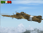
It was the most important Italian bomber of World War II, this tough three-engined aircraft established a reputation that contrasted with most Italian weapons of the day, and it was flown with courage and skill. SM.79s served widely in the normal bombing role, but it is as a land-based torpedo bomber that the type deserves its place in military aviation history, being regarded by many as one of the finest torpedo bombers of the war. In spite of its cumbersome appearance and outdated construction, with an internal provision for 2,750 lb (1,250 kg) of bombs, supplemented by under fuselage rack for a torpedo, the S.M.79 was a rugged, reliable multi-role medium bomber which did quite a bit of damage in the face of heavy opposition. About 1,300 production models were built over a nine year period. The SM.79 had a distinctive 'hump' on the upper forward fuselage, which housed both the fixed forward-firing heavy machine-gun and the dorsal gunner's position. Its appearance earned the aircraft the nickname 'Gobbo Maledetto' ('Damned Hunchback'). During the last phases of the war the surviving SM.79s were converted into various versions of utility transports and used in that role until 1952.
This "Service Pack" contains:
-4 UPGRADED + 1 NEW Hi-Res GMax models (5 different versions) feature the usual moving parts, such as all flight controls, props pitch and leading edge flaps.
-Eleven (11) different liveries (6 R.A., 1 A.N.R., 1 I.C.A.F., 1 Post-war A.M.I., 2 Spanish Nationalist Air Force).
-Revised SM.79M CFG & AIR files, New SM.79Bis CFG & AIR files
-Revised Sounds, Gauges & Effects
VC only. This plane was developed for FS9, but it works (it seems without problems) either in FSX. Created by Manuele Villa & ItalianWings, February 2008. Installation instructions included.
| Filename: | Savoia_Marchetti_SM79_Sparviero_SERVICE_PACK_1_v02.zip |
| License: | Freeware |
| Added: | 31st May 2010, 09:24:20 |
| Downloads: | 3,319 |
| Author: | Manuele Villa, Italianwings |
| Size: | 32.56 MB |
| Category: Flight Simulator 2004 - Aircraft Repaints, Textures and Modifications | |
| Italian Air Force "S.M.Luigi Gorrini" AerMacchi C.205 VELTRO (Greyhound) |
|
Images related to this file:
File Description:
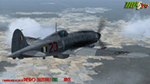
Regarded as the best Italian aircraft of World War II together with the Fiat G-55 Centauro,the Macchi-Castoldi C.205 proved to be extremely effective in action, destroying a large number of Allied bombers and capable of successfully clashing on equal terms with such renowned fighters as the North American P-51D Mustang.Although the C.205 was able to match the best Allied opponents both in speed and maneuverability,it was introduced late during the conflict.Moreover,due to the poor Italian industrial capability of the time,only a small production run was delivered to combat units before the end of the war.Famous C.205 pilots are Italy's highest scoring ace Adriano Visconti and the top scoring C.205 Sergente Maggiore pilota (Sargeant Major pilot) Luigi Gorrini.To date,there's still debate about
Gorrini's score,since Regia Aeronautica preferred crediting units over individual combat achievements.
Gorrini's official aerial combat score is 19 victories,but,according to his memories,he achieved 7 more during his service with Aeronautica Nazionale Repubblicana (A.N.R.), flying a Macchi C.205. These victories did not enter his officiall tally due to political reasons,since the A.N.R. fought by the side of the German Luftwaffe after the Italian September 8th,1943 armistice.These bring his total tally to 26 victories,making him the top scoring Italian fighter ace of WWII.For his combat record with the A.N.R he was awarded twice by the Luftwaffe with the Iron Cross First and Second Class.Luigi Gorrini was also awarded for his actions,after the end of the war,with the highest Italian military decoration,the "Medaglia d'Oro al Valor Militare" (M.O.V.M.,Gold Medal for Military Valour).Last surviving Italian fighter pilot of WWII,he died recently at the age of 97 and this repaint is dedicated to his memory.
Repaint by Manuele Villa/MVG3D, November 2014.
Requires the previous installation of the base Aermacchi C.205 Veltro package by Manuele Villa (C205_V01.zip).
| Filename: | Italian_Air_Force_SMLuigi_Gorrini_AerMacchi_C205_V.zip |
| License: | Freeware |
| Added: | 25th November 2014, 08:39:29 |
| Downloads: | 128 |
| Author: | Manuele Villa |
| Size: | 4.31 MB |
| Category: Flight Simulator 2004 - Scenery | |
| Iles de la Madeleine CYGR in Quebec Canada |
|
Images related to this file:
File Description:
The Iles de la Madeleine are a group of spit islands linked by bridges in the Gulf of St Lawrence. They are east of New Brunswick, north of Cape Breton Island, west of the Island of Newfoundland, and south of the mainland coast of Quebec. On a southwest to northeast axis they are 40 miles in length and the airport CYGR is pretty much at the midpoint of the southern line of islands. Take a look at the overhead from FS9 to see what I mean. CYGR has two runways, one is aligned 08-26 and is just under 4,400 feet long and 150 feet wide with lighting and PAPI at both ends. The second is aligned 16-34 and is 3,600 feet long and 150 feet wide, without lights or PAPI. Both are asphalt. The apron is not huge, and a newish (in 2010) hangar was built with separate access to the 16-34 runway. There are daily flights by Air Canada and Pascan Aviation included in the AI. The AI also includes some boats and a ferry, and I first used these with my Dutch Harbor scenery, so if you have that already.... This scenery also includes Cindy Hook, a small boat harbour just 2 miles southwest of the airport, and the larger harbour at Cap aux Meules a further 3 miles away that accommodates the daily ferry trips, along with fishing boats etc. Also included here is a further addition to the Homer PAHO scenery in the shape of a boat that is included in the Homer Spit harbour. Just add the contents of the scenery folder to the Homer scenery folder of your Homer installation, and the texture folder contents to the Homer texture folder. This is hopefully the last PAHO addition, and again apologies. If you find an error email me please, and note that my email address has been changed to rogwens at Gmail dot com.
| Filename: | Iles_de_la_Madeleine_CYGR_in_Quebec_Canada.zip |
| License: | Freeware, limited distribution |
| Added: | 28th July 2021, 17:02:18 |
| Downloads: | 188 |
| Author: | Roger Wensley |
| Size: | 26.7 MB |
| Category: Flight Simulator 2004 - Scenery | |
| Seward PAWD in Alaska V2 plus 6AK5 |
|
Images related to this file:
File Description:
This is V2, the combined original and also V1. If you have already installed V1 then you do not need this. The town of Seward (population around 2,700) is on the east coast of the Kenai Peninsula, 70 miles east of Kenai town and also 70 miles southeast of Anchorage, amid mountains and glaciers at the northern end of the 20 mile long and fjord-like Resurrection Bay. It is also at the southern end of both the Alaska Railway and the Seward Highway, and has a sheltered dock for freight and also for cruise liners. Passengers from the liners can enjoy local attractions (dog sledging on a glacier?) and also easily continue further north by bus or train to Anchorage or to other tourist attractions such as Denali. The airport is next to the port and the town, with two runways aligned (in FS9, not taking account of the recently wandering magnetic north) 15-33 and 12-30, both asphalt and 2,100 and 4,200 feet long respectively. Only 12-30 (and its taxiways) is lit, with VASI on 30. There are no regularly scheduled flights to Seward; with buses and trains running direct from Anchorage there is no money to be made. There are some charter flights coordinated with cruise liners, and some freight flights, the very occasional visit by the Coastguard, but most flights are GA, air taxi,or short scenery-viewing trips for summer tourists. In a mountainous area the only sure thing about the behaviour of AI aircraft is that it is unpredictable but often involves a mountain; nothing to be done about it. At Seward there is also marine AI from and to the port, in the shape of a cruise liner and an Alaskan ferry, but the latter only if you have Holger Sandmann's Alaska scenery installed. Also included with this is a correction for Fire Island 6AK5, near Anchorage, that takes the airfield out of the water; this is something I have meant to do for the last 5 years.
| Filename: | Seward_PAWD_in_Alaska_V2_plus_6AK5.zip |
| License: | Freeware, limited distribution |
| Added: | 19th January 2016, 18:27:26 |
| Downloads: | 591 |
| Author: | Roger Wensley |
| Size: | 12.47 MB |
| Category: Flight Simulator 2004 - Scenery | |
| Coal Harbour CAQ3 float base in British Columbia, Canada |
|
Images related to this file:
File Description:
This is number eight in a series of new and renovated float bases in BC. Coal Harbour is in a sheltered cove off Holberg Inlet on the northwest coast of Vancouver Island, close to the village and 10 miles southwest of the Port Hardy float base. There is 100LL fuel and oil available. Due to the deep fjords that run into Vancouver Island from the west coast Coal Harbour is actually closer to the east coast than it is to the west coast. The tortuous route in through Quatsino Sound and Rupert Sound shelters the waters of Holberg Inlet from the stormy seas of the west coast, and fishing boats take advantage of this. The floatplane dock is to the south of the large (and old) hangar, adjacent to the southern end of the fixed dock where the ramp bridge descends to the floating docks. The video makes it clearer. The AI is a further adaptation of the CF36 AI and involves Beavers and Otters as listed in the AI folder. Due to the surrounding hills there may be some interference with AI aircraft, depending on the wind direction, though I have watched succesful Beaver and Otter landings. Amid the hills there is a very large hole in the ground to the east. The village name suggests it may have been for coal but though in fact there was a coal mine, that was a much smaller and unsuccesful venture; this particular scene of enthusiastic digging was for copper, until 1996. The main claim to fame of Coal Harbour was that it was the last whaling station in North America, using the buildings that were part of the RCAF float plane patrol base during WW2. One downloader reported a texture problem with Port McNeill, to which we found a solution. As he was the only person to email me I am going to presume that nobody else had the problem.
| Filename: | Coal_Harbour_CAQ3_float_base_in_British_Columbia_C.zip |
| License: | Freeware, limited distribution |
| Added: | 25th January 2017, 00:29:05 |
| Downloads: | 224 |
| Author: | Roger Wensley |
| Size: | 7.79 MB |
| Category: Flight Simulator 2004 - Original Aircraft | |
| Savoia Marchetti SM.79 Sparviero (V.01) |
|
Images related to this file:
File Description:

It was the most important Italian bomber of World War II, this tough three-engined aircraft established a reputation that contrasted with most Italian weapons of the day, and it was flown with courage and skill. SM.79s served widely in the normal bombing role, but it is as a land-based torpedo bomber that the type deserves its place in military aviation history, being regarded by many as one of the finest torpedo bombers of the war.
The basic design continued the company's tradition of mixed construction with steel tubes light alloy wood and fabric (this being the only way to produce in quantity with available skills and tools); in spite of its cumbersome appearance and outdated construction, the S.M.79 was a rugged, reliable multi-role medium bomber which did quite a bit of damage in the face of heavy opposition. About 1,300 production models were built over a nine year period. They had internal provision for 2,750 lb (1,250 kg) of bombs, supplemented by under fuselage rack for a torpedo. The SM.79 had a distinctive 'hump' on the upper forward fuselage, which housed both the fixed forward-firing heavy machine-gun and the dorsal gunner's position. Its appearance earned the aircraft the nickname 'Gobbo Maledetto' ('Damned Hunchback'). Post-war surviving SM.79s were converted into various versions of utility transports during the last phases of the war and survived in that role until 1952.
Complete aircraft. 4 Different Hi-Res GMax models (4 different versions), features the usual moving parts, such as all flight controls, props pitch and leading edge flaps. Six different liveries (2 Regia Aeronautica, 1 A.N.R./R.S.I. , 2 Spanish Nationalist Air Force, 1 Italian Co-Belligerant Air Force); VC only. Tested in FSX. Original CFS3 Model by Italianwings, converted and modified for FS2004 by Manuele Villa, January 2008. Installation instructions and paint-kit included.
| Filename: | Savoia_Marchetti_SM79_Sparviero_V01.zip |
| License: | Freeware |
| Added: | 26th May 2010, 10:19:15 |
| Downloads: | 5,014 |
| Author: | Manuele Villa, Italianwings |
| Size: | 27.75 MB |
| Category: Flight Simulator 2004 - Panels | |
| PS Panels 737NG |
|
File Description:
Built completely from scratch, the PS Panels 737NG incorperates a high level of realism whilst still allowing the virtual pilot to use important FS features such as the flight planner and ATC systems.
Authentic NG EHSI
The PS Panels 737NG incorporates a high definition EHSI display including all the modes as per the real aircraft.
Approach, VOR, Map and Plan modes are all modelled (APP, VOR and Map in both Expanded and Standard modes).
The authentic and fully animated EHSI control panel allows the virtual pilot to set the display to his preference.
The PS Panels 737NG interfaces completely with the FS Flight Planner, you're flight plan will be automatically displayed in both the Plan and Map modes.
Extensive Overhead
The PS Panels 737NG incorporates a custom overhead panel to control the many modelled aircraft systems.
Based on the real NG Overhead panel with a slightly altered layout that allows the virtual pilot to continue to monitor his key instruments whilst managing the Fuel, Electrical, Hydraulic, Lighting and Pnuematic systems controlled through the panel.
Careful attention combined with detailed research has allowed us to model these systems to a high degree of accuracy.
Complete Radio Stack
The panel comes with an authentic 737NG radio stack, accurate down to the last details.
IRS System
The PS Panels 737NG models the operation of the aircrafts IRS. Unless proper alignment is completed through the IRS panel, many features of the aircraft's displays will be INOP.
Custom Throttle Panel
The panel comes with a custom throttle panel accurate to that on the real aircraft.
Advanced 2-stage Night Lighting
A first for PS Panels, the 737NG contains two stage night lighting allowing the virtual pilot to choose between two levels of cockpit lighting on the fly.
The main panel and all subpanels are lit using the same schemes.
Thanks to Yoo Sang Jun for his work on this.
| Filename: | PS_Panels_737NG.zip |
| License: | Freeware, limited distribution |
| Added: | 7th July 2007, 22:06:00 |
| Downloads: | 26,669 |
| Author: | Paul Scarratt |
| Size: | 4.1 MB |
© 2001-2026 AVSIM Online
All Rights Reserved
Privacy Policy |