
Where Flight Simulation Enthusiasts Gather from Around the World!
AVSIM Library - Search Results

| Category: Flight Simulator 2004 - Scenery | |
| Astrakhan City topology and autogen |

|
Images related to this file:
File Description:

I'm pleased to introduce you the project of topology and autogen of Astrakhan city, Russia, version 1.0b. The project is for MS Flight Simulator 2004.
This projects changes the default autogen of the city and its neighborhood, that doesn't correspond to the real city. Also it adds missing rivers, islands, roads, railroads, and bridges in the vicinity of the city and Astrakhan aerodrome (URWA) and removes non-existent bridges across the Volga river.
This scenery is not professional since I designed it to my own cheek in Ground2K4 to replace the default terrible scenery and make my flights to homeland more comfortable. That's why it is probable, that you can face some challenges (although, I didn't see any problems yet). The project has several disadvantages: all bridges are autogen, so they don't look very similar to real ones (but they are better, that their absence and presence of several non-existent :) ); no autogen on added islands (although the autogen option for them is set on in Ground2K4), I will continue to work on it; rivers that fall into the Volga river have the default shoreline visible at theirs mouths (it's possible to remove it, but only on the square of big area, in that case the river-land transition doesn't look real).
Overall, this project is more for IFR flights, than VFR. But, again, even for VFR flights it's much better than the default crap (imho!).
| Filename: | Astrakhan_City_topology_and_autogen.zip |
| License: | Freeware |
| Added: | 2nd July 2010, 15:18:39 |
| Downloads: | 430 |
| Author: | Valery 'Oracle' Smirnov |
| Size: | 11.23 KB |
| Category: Flight Simulator X - AFCAD Files | |
| Stallone Airport (9NJ5), NJ |
|
File Description:
Located 01 miles SE of Harrisonville, New Jersey, Stallone Airport is a private turf strip 1350' in length. However it should be noted that the actual length from the road to the trees on the opposite end of the runway is actually only around 900'. It is tightly hemmed in by trees so if you are landing on Runway 29 you may want to use Slew to turn your plane around to remove the risk of bumping into a tree instead. If you land on Runway 11 you can cross the road to turn around in the field opposite the runway. The windsock can be seen from both runways. Power lines run along the heights of the trees as well for the Runway 29 approach, on the same side as the trees though so not really any additional worry there. No transient services are available. There is no hard surface runway so make sure your terrain mesh slider is set as high as possible for a suitably bumpy ground experience.
Scenery constructed with use of satellite images/streetview/aerial photos - the author has not been there in person.
This scenery is meant to be used in conjunction with MegaScenery Earth New Jersey/Delaware 004. It is not required, but apron use is minimized to allow satellite scenery to show through as much as possible, and objects are placed based on the MSE textures - lack of it may make scenery look out of place.
| Filename: | Stallone_Airport_9NJ5_NJ.zip |
| License: | Freeware |
| Added: | 5th April 2011, 07:34:54 |
| Downloads: | 170 |
| Author: | Drew Sikora |
| Size: | 332.91 KB |
| Category: Flight Simulator X - Scenery | |
| Pagasa Island, Philippines |
|
Images related to this file:
File Description:
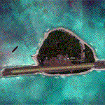
Pagasa Island is a jewel in the South China Sea. It is the one pictured - an emerald splash in an azure sea slashed by a coral runway - whenever new collisions or confrontations are reported in the news for the region. Occupied continuously by the Philippines since 1971, historical use dates back to the Han dynasty, which many believe forms the basis of the Chinese claim to the island. Each country has it's own interpretation of international law and the Filipinos are clearly banking on the precedence of continuous occupation, at no small expense, as Rancudo Field is the farthest airport from Manila within the Philippine sphere of control.
Surprisingly, the geography of the island serves to capture and retain rainwater, although the aquifer is stagnant and the water must be treated for consumption. Sea life remains abundant, poachers take coral heads and sea turtles. There is a solar farm and recently installed solar street lights, fuel for the generators is a precious commodity this far from the mainland.
Sadly, nature may solve the struggle for possession by withdrawing the island from the arena. It is believed that the construction of the runway may have compromised the islands basic integrity, allowing it to crumble into the sea. Whatever the cause, the evidence is clear. Bunkers built during the Japanese occupation in WWII are already slipping beneath the waves and the rate of salt water encroachment has been recorded at close to 6" per day.
There are some things to explore, the grounded BRP Laneo Del Norte to the west; over to the north near the resort grounds are a dugout fishing canoe and some authentic Philippine bangka boats; you may want to load up and head east to do some low warning passes over the Chinese fishing fleet. Standing at the east end of the field, you can just barely spot the China Coast Guard cutter's smoke on the horizon.
The tower is marked by a bright strobe that fires once every five seconds and at night it is bright enough to guide you back to the island from the distance of the fleet. There are no published procedures and the tower is not staffed. Airport ICAO is RPPN.
| Filename: | Pagasa_Island_Philippines.zip |
| License: | Freeware, limited distribution |
| Added: | 10th May 2014, 12:21:19 |
| Downloads: | 1,851 |
| Author: | Rick Keller |
| Size: | 16.17 MB |
| Category: Prepar3D V1-4 - Scenery | |
| Loreto Marche Italy N 43.26.27 E 13.36.36 |
|
File Description:
Loreto Marche Italy (N 43.26.27 E 13.36.36) Loreto is an Italian town in the province of Ancona in the Marche region
and is famous for being the headquarters of the Basilica of the Santa Casa, one of the most important and ancient places
of Marian pilgrimage in the Catholic world. The city rises on the top of a gentle hill, with a wide countryside around
characterized by the cultivation of the olive tree. The shape of the dome and the bell tower of the Basilica, whose
top is the figure of the Madonna, stands out for its height and majesty. The Basilica houses the famous relic of the
"Holy House" of Nazareth where, according to tradition, the Virgin Mary was born and lived where he received the
announcement of the miraculous birth of Jesus. The panorama that can be enjoyed ranges from the Adriatic Sea to Monte
Conero, up to the Umbrian-Marche Apennines. Important VFR point for approaching airport Ancona Falconara. Within the
downloaded package you will find readme files for scenery installation. Good fly VFR. Pasquale Marrulli.
| Filename: | Loreto_Marche_Italy_N_432627_E_133636.zip |
| License: | Freeware |
| Added: | 4th May 2018, 04:42:54 |
| Downloads: | 163 |
| Author: | Pasquale Marrulli |
| Size: | 19.22 KB |
| Category: Flight Simulator X - Scenery | |
| RAF Hilbaldstow - Lincolnshire, England |
|
File Description:
RAF Hibaldstow is a former Royal Air Force satellite airfield located south of Hibaldstow in Lincolnshire and 8.3 miles (13.4 km) south east of Scunthorpe, Lincolnshire, England. The airfield was built with greater things in mind, but it only became a satellite airfield for RAF Kirton-in-Lindsey in 1941. When the runways were constructed, some of the hardcore was made from material taken from demolished bungalows on the site.
The airfield was commissioned on 12 May 1941 when No. 255 Squadron RAF took up residence with their Boulton Paul Defiant night fighters. These planes had been drawn from RAF Kirton-in-Lindsey and made one 'kill': an He 111 which was shot down near Louth on 5 June 1941.
On 6 August 1947 the station finally closed and during 1960-61 it was sold off for use as agricultural land. It was also used for Sunday markets, as a skid-pan by Lincolnshire Police and by a local parachute club. The control tower was converted to a two-storey house in 1976.
| Filename: | RAF_Hilbaldstow__Lincolnshire_England.zip |
| License: | Freeware |
| Added: | 24th October 2015, 22:00:30 |
| Downloads: | 202 |
| Author: | Terry Boissel |
| Size: | 24.85 KB |
| Category: Flight Simulator X - Scenery | |
| RAF Hutton Cranswick |
|
File Description:
RAF Hutton Cranswick opened in January 1942 as a fighter airfield within No. 12 Group RAF. Unusually for the time its three runways were concrete "from new", many airfields (particularly fighter airfields) were initially built with grass runways which were later upgraded to concrete.
Many squadrons rotated through the airfield including 610, 19, 308 (City of Kraków), 316 (City of Warsaw), 195, 306 (City of Torun), 302 (City of Poznan), 315 (City of Deblin), 234, 168 and No. 170 Squadron RAF. From December 1943, the Anti-Aircraft Co-operation 291 Squadron was formed at the airfield for target towing and similar uses.
Whilst in use by 291 other fighter squadrons continued to rotate through including 401, 403, 412, 441, 442, 443 (all flying Supermarine Spitfires) and 439 using Hawker Typhoons. The final unit to operate from Hutton Cranswick was No. 124 Squadron RAF using Spitfire IXs.
The station closed in 1946 and has reverted back to farm land, an industrial site now stands were the tech site was situated and the tower became a house.
Source:Wikipedia
| Filename: | RAF_Hutton_Cranswick.zip |
| License: | Freeware |
| Added: | 27th February 2017, 15:12:55 |
| Downloads: | 125 |
| Author: | Terry Boissel |
| Size: | 4.95 MB |
| Category: Flight Simulator 2004 - AFCAD Files | |
| Newark Liberty Int'l Airport (KEWR) with active Crosswind Runway |
|
Images related to this file:
File Description:
A high spec AFCAD2 for the FS2004 Newark Liberty Int'l Airport (KEWR) scenery by Steve Whalin. This afcad has been built using FAA Charts and information from the Airport Website. All taxiways are named and all aprons are reworked to be as real as possible according to photos. All gates are named as per real life and have airlines assigned to them. The Fedex and UPS aprons are represented and can accomodate many cargo aircraft. The final addition is random GA parking and the CO maintenance area to the north of the airport. Overflow parking is also available for rush hour periods (Ball Park). This airport features a tower view and also night and approach lighting. Finally, by using the crosswind runway technique, runways 04L/22R, 04R/22L and 11/29 can all be used simultaniously for take-off and landing. Runway 11/29 will be mainly used by CO Express flights. Enjoy!!
This afcad works with the Steve Whalin scenery only (Requires: kewr.zip).
| Filename: | Newark_Liberty_Intl_Airport_KEWR_with_active_Cross.zip |
| License: | Freeware |
| Added: | 2nd March 2010, 19:26:13 |
| Downloads: | 1,355 |
| Author: | Lee Brompton |
| Size: | 259.8 KB |
| Category: Flight Simulator X - Sounds | |
| Douglas DC-8-63 P&W JT3D-7 Sound Pack |
|
File Description:
SkyHigh Audio Simulations is proud to present what is quite possibly the most realistic sounding Pratt & Whitney JT3D-7 Turbofan sound pack available! This sound pack is designed to work with Historic Jetliners Group's Douglas DC-8-63 model. There are two versions of this sound pack, one interior point of view from the cockpit, and the other being the passenger cabin POV in front of the engines. This sound pack includes many unique and realistic features, including realistic 3D sound cones giving a very realistic exterior sound experience, especially in the fly-by view mode. Also using the cone technology, realistic distant taxi howling and distant rumbling sounds are included. The plane could be heard loud and clear from up to 2km away in tower view! Realistic start up sounds featuring external air cart compressor howling noises are included. Realistic interior ambience noises such as the inverter noise and touchdown, flaps, gear sound with chime, and more are featured in this sound pack. Please visit our website at: www.skyhighflightsim.webs.com for more info and sound packs!
| Filename: | Douglas_DC863_PW_JT3D7_Sound_Pack.zip |
| License: | Freeware |
| Added: | 3rd September 2011, 04:27:55 |
| Downloads: | 3,081 |
| Author: | Adam Murphy and Jesse Casserly - Skyhigh Audio Simulations |
| Size: | 43.51 MB |
| Category: Flight Simulator X - AFCAD Files | |
| CYxs Prince Geroge - British Columbia, Canada |
|
File Description:
I have completely reconstructed CYXS using ADE (v1.40), Google Earth satellite images and current airport chart. Runways have been repositioned and runway 15/33 extended from 7400 ft to 11450 ft. ILS has been added to runway 33. Roads, parking areas and new buildings added. Aprons readjusted. Automated jetways added. Parking for AI aircraft and refueling truck added. Additional scenery objects have been added and to view these will require you to install additional files as described below. Airport views are from the roof of the control tower.
Latest News: YXS - The New Transpacific Logisitics Alternative
The Runway Expansion Project has transformed runway 15/33 from 7,400 ft. to 11,450 ft., complete with centre line (LED) lighting, dual ILS navigational systems and a dedicated de-icing refueling pad for wide body aircraft. Once completed, the Runway Expansion Project will allow the PGAA to market the airport as a new transpacific logistics alternative, providing carriers the opportunity to make Prince George a destination of choice for refueling and transshipment of cargo
| Filename: | CYxs_Prince_Geroge__British_Columbia_Canada.zip |
| License: | Freeware |
| Added: | 5th November 2009, 02:16:13 |
| Downloads: | 747 |
| Author: | Robert Catherall |
| Size: | 878.39 KB |
| Category: Flight Simulator 2004 - AFCAD Files | |
| Metro Oakland Int'l (KOAK) with Active Crosswind Runways |
|
File Description:
A high spec AFCAD2 for the default FS2004 Metro Oakland Int'l Airport (KOAK). This afcad has been built from scratch using FAA Charts, various aerial photographs and information from the Airport Website. All runways feature real life lengths/widths and include overrun areas. All taxiways are named and all aprons are reworked to be as real as possible according to photos. All gates are named and have airlines assigned to them. As per real life, only Southwest Airlines will use Terminal 2, all other airlines being allocated to Terminal 1. The Fedex and UPS aprons are represented and can accomodate up to 20 cargo aircraft. The final parking area is random GA parking to the north of the airport. Overflow parking is also available for rush hour periods. This airport now features a tower view and also upgraded night and approach lighting. Finally, by using the crosswind runway technique, runways 9L/27R, 9R/27L and 11/29 can all be used simultaniously for take-off and landing. Runway 15/33 is closed as it is not used in real life. Enjoy!!
| Filename: | Metro_Oakland_Intl_KOAK_with_Active_Crosswind_Runw.zip |
| License: | Freeware, limited distribution |
| Added: | 30th July 2005, 06:15:21 |
| Downloads: | 2,529 |
| Author: | Lee Brompton |
| Size: | 80.4 KB |
© 2001-2026 AVSIM Online
All Rights Reserved
Privacy Policy |