
Where Flight Simulation Enthusiasts Gather from Around the World!
AVSIM Library - Search Results

| Category: Flight Simulator X - Scenery | |
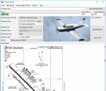
| Burke Lakefront Airport (KBKL), Clevland, Ohio |

|
Images related to this file:
File Description:

File Description:
This airport was made using Google sketch up 8, Airport Facilitator X and Instant Scenery 2. Burke Lakefront Airport is a general aviation airport located next to Lake Erie in Cleveland, Ohio. I have made custom 3D buildings using Google sketchup for the airport. This update makes it so that all the buildings will show because some people were having problems with the buildings. All the buildings have photo textures to make it closer to real life. The update also makes it so that the airport ICAO is not included in the airport name and an installer program is included. I put static aircraft on the ramp, airport vehicles and more fuel trucks. I added more parking and fuel spots. I also made a parking lot full of cars. If you choose to start off at a DOCK gate, you will start off inside one of the custom hangars. Starting off or taxiing inside of a hangar will cause a crash (unless you have crashes turned off). I added a helipad located near the FBO. I have also included the aviation high school, that is located at the northeast, and boats that are right next to it in the water. There will be more objects at the airport if your scenery complexity is set to normal (such as vehicles, aircraft, and fuel trucks). Tower view is from the roof of the control tower. This was all made based on Google Earth satellite imagery and Bing Maps. There are no night textures for the custom buildings. These will be added in a future version. Please read the readme for instructions on how to install. You do not need the original file for this update to work. This is for flight simulator X only. By Tyler Lawrence.
| Filename: | Burke_Lakefront_Airport_KBKL_Clevland_Ohio.zip |
| License: | Freeware |
| Added: | 7th April 2012, 11:42:42 |
| Downloads: | 1,346 |
| Author: | Tyler Lawrence |
| Size: | 6.82 MB |
| Category: Prepar3D V1-4 - Scenery | |
| KSTC - St. Cloud Rgnl - St. Cloud, MN, USA |
|
File Description:
KSTC - St. Cloud Rgnl - St. Cloud, MN, USA version 1.1 by Jason Boche
This is an update of the default P3Dv4.5 KSTC airport.
Enhancements include:
-National Guard added to south end of the airport
-Jetway and west terminal extension added
-Aircraft parking updated
-General aviation area updated
-Runways and taxiways updated with asphalt edging
-Updated RWY 31 frequency to 111.9 and removed backcourse (I-STC ident)
-SIYON and OSACA terminal waypoints added (IAF and FAF respectively for ILS 13)
-Default ILS 13 backcourse approach replaced with ILS or LOC/DME RWY 13 approach with frequency 111.9 (I-BPM ident)
-LOC/DME antennea added
-Tower replaced and moved
-PAPI lights moved
-Asphalt and concrete aprons added/updated
-Asphalt, concrete, and gravel roads and parking lots added
-All applicable runway signs updated
-Added vehicles
-Airport perimeter fencing updated
-Flag and trees added
-Beacon adjusted
| Filename: | KSTC__St_Cloud_Rgnl__St_Cloud_MN_USA.zip |
| License: | Freeware |
| Added: | 13th May 2020, 17:21:45 |
| Downloads: | 111 |
| Author: | Jason Boche |
| Size: | 19.19 KB |
| Category: Prepar3D V1-4 - Utilities | |
| FS Flight Builder |
|
Images related to this file:
File Description:
FS Flight Builder is a utility for general aviation flying that will build flight files for FSX (flt), FSX Steam Edition (flt), and Prepar3D (fxml) based on waypoints and other data either entered manually or imported from SkyVector using the Plain Text Link information. Among other things, you can select your starting position, aircraft, and a VFR or IFR flight plan.
One of the most interesting features of the application is that it will include a Briefing file, added to the aircraft's built-in kneedboard, that will include departure and destination airport information (runways, frequencies, weather, and charts) as well as navigation frequencies along the route.
Included is a new destination chooser function that allows you to enter your departure airport and additional criteria, such as min and max distance, tower required, ILS, runway length restrictions.
| Filename: | FS_Flight_Builder.zip |
| License: | Freeware |
| Added: | 30th July 2018, 03:56:07 |
| Downloads: | 148 |
| Author: | Tom Arduini |
| Size: | 28.24 MB |
| Category: Prepar3D V1-4 - Scenery | |
| Barletta Puglia Italy N41.19.15 E16.17.19 |
|
Images related to this file:
File Description:
Barletta Puglia Italy N41.19.15 E16.17.19. The city is characterized by the Castle of Barletta a quadrangular building with, at the corners, the characteristic lance-shaped towers-walls, dating back to the eleventh century, was built by the Normans, as evidenced by the largest tower incorporated in the southern area of the current building. During the Crusades it became a habitual shelter for the knights departing and arriving from the Holy Land. Important is also the Cathedral with its opposite square where the "Colossus of Barletta" is found a large bronze statue 4,50mt of the 5th Century depicting a senior officer of the Roman army called, according to the legend, Heraclius.Important VFR point for approaching airport Bari Palese or Foggia Gino Lisa. Within the downloaded package you will find readme files for scenery installation. Good fly VFR. Pasquale Marrulli.
| Filename: | Barletta_Puglia_Italy_N411915_E161719.zip |
| License: | Freeware |
| Added: | 11th December 2017, 19:19:06 |
| Downloads: | 209 |
| Author: | Pasquale Marrulli |
| Size: | 2.73 KB |
| Category: Flight Simulator 2004 - AFCAD Files | |
| Grand Rapids with Active Crosswind Runways |
|
File Description:
An AFCAD2 for Gerald R. Ford Int'l Airport, Grand Rapids, MI. This file will give you over 60 parking spots at the airport. Real life airline gates are now provided at the terminal and an extensive GA area is also available for use. Taxiways have been improved, night lighting added to the airport and an accurate tower view is now provided. A cargo area on the eastern side of the airport is also provided, with correct cargo airline assignments. All runway lengths are accurate as per real life. Finally, by using the crosswind runway technique, all runways at this airport are now active for simultaneous take-offs and landings. Credit goes to 'Skyhawk Driver' for giving me the idea of working on a new AFCAD2 for this airport. This is for the default FS2004 airport only.
| Filename: | Grand_Rapids_with_Active_Crosswind_Runways.zip |
| License: | Freeware |
| Added: | 9th March 2005, 13:39:34 |
| Downloads: | 951 |
| Author: | Lee Brompton |
| Size: | 42.08 KB |
| Category: Flight Simulator 2004 - Scenery | |
| PAMR - Merrill Field - Anchorage, Alaska |
|
Images related to this file:
File Description:
Merrill Field is in Anchorage Alaska, between Anchorage International to the southwest and and Elmendorf Air Force Base to the north. It caters for general aviation and is the land equivalent of the Lake Hood float plane base (see my post) with fuel and numerous maintenance facilities, and several hundred parking spots for small planes. There are three runways, and the longest is 4,000 feet of 100 feet wide asphalt, the second 2,635 feet of asphalt 75 feet wide, and the third 2,000 feet of 60 feet wide gravel. It is a controlled airfield with a modern control tower. There are almost 50 buildings on the field and three quarters of them have been modeled specifically for this scenery. The download includes a LITE version for older computers as there are a lot of static parked aircraft.
| Filename: | PAMR__Merrill_Field__Anchorage_Alaska.zip |
| License: | Freeware, limited distribution |
| Added: | 3rd January 2011, 23:11:31 |
| Downloads: | 1,122 |
| Author: | Roger Wensley |
| Size: | 6.94 MB |
| Category: Flight Simulator X - Scenery | |
| Frankfurt Main Airport with new 25L/R ILS approaches (v2.1) |
|
Images related to this file:
File Description:
This scenery is a minor update to v2.0 of the FSX Frankfurt/Main airport package and was designed using ADE v1.40.
This change updates the 25L ILS frequency from 110.70MHz to 111.15MHz at EDDF as per change at the real EDDF on 28Oct2009. All other features remain unchanged.
Features include additional jetways, vehicle roadways around Terminal 2, up-to-date airline mapping to gates and additional taxiway and CAT II/III signs.
** Gates have been resized and added as per current layout
** Additional fuel trucks & support vehicle roads built around the airport
** 3 helipad start locations added
** B Gates now contain double jetways
** The control tower view has been moved to the south side and aprons have been remodelled
** 25L and 25R ILS Rwy frequencies now updated.
| Filename: | Frankfurt_Main_Airport_with_new_25LR_ILS_approache.zip |
| License: | Freeware |
| Added: | 15th November 2009, 12:20:37 |
| Downloads: | 2,776 |
| Author: | Mark Aldridge |
| Size: | 3.06 MB |
| Category: Flight Simulator X - Scenery | |
| Frankfurt Main Airport v6.0 (EDDF) scenery |
|
Images related to this file:
File Description:
This major scenery update for Frankfurt Main Airport supersedes v5.3 and now includes the new A-plus terminal with 7 gates (4xA380) complete with real-world textures and night lighting, a new lighted control tower model plus a whole new set of custom built Gmax models of airport buildings which help add realism to the airport. Also modelled is the extended G Apron on the south side now with parking spots and night lighting, the Rwy 18 blast fence and A380 engine blast wall. Also included in this package are the latest airport runways/taxiway designations including latest updates to taxiway Sierra, ILS frequencies and navaids including the new VOR as per May 2012. Default FSX scenery is required.
Also includes updated airline codes for gate parking and other minor defect fixes.
See readme/help file for more details.
| Filename: | Frankfurt_Main_Airport_v60_EDDF_scenery.zip |
| License: | Freeware |
| Added: | 26th May 2012, 23:57:36 |
| Downloads: | 7,389 |
| Author: | Mark Aldridge |
| Size: | 7.03 MB |
| Category: Flight Simulator 2004 - Scenery | |
| Matheson Point CWMP in Nunavut, Canada |
|
Images related to this file:
File Description:
This was a DEW line I Station on the southeast shore of King William Island; the island is around 70 miles square and Gjoa Haven is also on the southeast corner, 20 miles to the south. The station was closed in 1963 and has now been totally dismantled and removed except for a fallen 300 feet communications tower. The runway is still there (mostly) and is around 3,360 feet of gravel 120' wide, aligned 146T/326T. There are no lights, signage, or windsock, or any building remaining. All of these DEW line stations are not particularly impressive or even interesting. However, you can bet that any pilot flying regularly in the north along the coast knows where all these runways are, in case one of them suddenly becomes his favourite in the whole world just after the sudden silence.
| Filename: | Matheson_Point_CWMP_in_Nunavut_Canada.zip |
| License: | Freeware, limited distribution |
| Added: | 22nd November 2012, 16:28:19 |
| Downloads: | 178 |
| Author: | Roger Wensley |
| Size: | 785.57 KB |
| Category: Flight Simulator X - Scenery | |
| KDAY - Dayton International Airport - Vandalia, Ohio |
|
Images related to this file:
File Description:
The Dayton International Airport, located 11 miles north of Dayton in Vandalia, Ohio, is a medium sized commercial airport serving nearly three million passengers annually with daily nonstop service to about twenty destinations.
This scenery includes a custom terminal building, moving jetways, and an AFX file with accurate parking assignments. Also modeled is the new air traffic control tower, terminal parking garage, the Fed Ex building, the PSA Airlines headquarters and maintenance hanger, the former Emery Worldwide cargo sort facility, the airport hotel, and hangers for fixed base operators Stevens Aviation and Wright Brothers Aero.
More than a thousand objects have been added to enhance detail around the airport using Flight 1's excellent instant scenery program. AI Traffic has been tested to ensure efficient flow. The landclass file has also been adjusted to better reflect the real airport.
| Filename: | KDAY__Dayton_International_Airport__Vandalia_Ohio.zip |
| License: | Freeware |
| Added: | 2nd December 2012, 22:32:37 |
| Downloads: | 1,567 |
| Author: | Matt Parr |
| Size: | 5.78 MB |
© 2001-2026 AVSIM Online
All Rights Reserved
Privacy Policy |