
Where Flight Simulation Enthusiasts Gather from Around the World!
AVSIM Library - Search Results

| Category: Flight Simulator 2004 - Scenery Design | |
| EZ-Inland River Barges Object Library |

|
File Description:
EZ-Inland River Barges Object Library
For FS2004. Contains a mixture of various Inland River Barges (16 Barges including 3 different Office Barges for Barge Fleets) as is commonly seen on the Mississippi River and it's tributaries. Textures are a mix of DXT3 and 8bit.Barges also feature Timberheads and Cavels as seen on the real thing. This will be the final relese of our universal object libraries, the rest will be included in the KBTRv2 Scenery package which is now in Beta Testing. Please visit www.flightlevel390.org for more info. Use these objects in conjunction with Ron Jeffers EZ Maritime2 Object Library for the Towboats, and some of his own custom barges, His EZ Effects contain small black smoke (animated FX) which when placed over the stacks on the towboat bring it life.
You may use these Objects with your own Freeware Scenery Projects.
I have included the XML files from the other 2 object libraries to allow Scenery Designers to use other programs other than EZ Scenery to place my objects. -See Zipdive for more screenshots
| Filename: | EZInland_River_Barges_Object_Library.zip |
| License: | Freeware |
| Added: | 30th May 2007, 19:20:38 |
| Downloads: | 1,551 |
| Author: | FlightLevel390 |
| Size: | 1.45 MB |
| Category: X-Plane - Scenery | |
| BR SP SBGP - Gaviao Peixoto Embraer Airport v1.0.0 |
|
Images related to this file:
File Description:
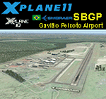
This is an X-Plane 11 and X-Plane 10 scenery package for Embraer Unidade Gavião Peixoto Airport (ICAO: SBGP, no IATA code) is a private airport located in a rural area near Gavião Peixoto and Araraquara, in Brazil. It is owned and operated by Embraer and used as for testing civil and military aircraft. Additionally, this scenery also includes a grass airstrip (SJAW Fazenda Citrica Airfield), a rural citrical farm facility for agricultural aviation. You can try landing there with your favorite prop aircraft. It's located around 1nm or 2nm northeast of SBGP airport. It includes corrected aprons, ramps, gates, taxiways, lighting system, Araraquara city buildings, ortho-photoscenery for the airfield area, and (XP11 only) airport ground services (like push back). This scenery was tested and is operational (as of March 18, 2017) in "X-Plane 11 Public Beta #15 64 bit", Windows 10 Home. It was also tested and is also operational (as of March 18, 2017) in "X-Plane 10.51 64 bit", Windows 10 Home. Only the default X-Plane 11 libraries, by Laminar Research, are needed. No third party libraries are used.
| Filename: | BR_SP_SBGP__Gaviao_Peixoto_Embraer_Airport_v100.zip |
| License: | Freeware |
| Added: | 19th March 2017, 08:13:27 |
| Downloads: | 95 |
| Author: | Rui Mesquita |
| Size: | 21.63 MB |
| Category: X-Plane - Scenery | |
| US MI KBTL - WK Kellogg Airport Battle Creek v2.0.0 |
|
Images related to this file:
File Description:

This is an X-Plane 11 and X-Plane 10 scenery package for the W.K. Kellogg Airport (IATA: BTL, ICAO: KBTL, FAA LID: BTL), which is a city owned, public use, joint civil-military airport located three nautical miles (6 km) west of the central business district of Battle Creek, a city in Calhoun County, Michigan, United States. v2.0.0 completely replaces the KBTL v1.0.2, with a brand new scenery, including orthophoto and city building for downtown Battle Creek. For better performance, only the default X-Plane libraries, by Laminar Research, are needed. No third party libraries are used. It includes corrected aprons, ramps, gates, taxiways, lighting system, city downtown buildings, ortho-photoscenery for the airfield area, and (XP11 only) airport ground services (like push back). This scenery was tested and is operational (as of March 20, 2017) in "X-Plane 11 Public Beta #15 64 bit", Windows 10 Home. It was also tested and is also operational (as of March 20, 2017) in "X-Plane 10.51 64 bit", Windows 10 Home. Only the default X-Plane libraries, by Laminar Research, are needed. No third party libraries are used.
| Filename: | US_MI_KBTL__WK_Kellogg_Airport_Battle_Creek_v200.zip |
| License: | Freeware |
| Added: | 22nd March 2017, 00:06:30 |
| Downloads: | 69 |
| Author: | Rui Mesquita |
| Size: | 22.38 MB |
| Category: Flight Simulator 2004 - Scenery Design | |
| FSX2FS9 Converts FSX Airport Files for Use in FS9 |
|
Images related to this file:
File Description:

FSX2FS9 is a utility based on the ScruffyDuck Scenery Design Engine. It allows users to convert Airport Files designed for FSX for use in FS9. The program provides user control over the conversion process including selection of elements to be removed prior to conversion, handling of vehicle path networks and handling of those items in the FSX file which would cause the FS9 compiler to fail. The user also has the choice of whether to allow the program to automatically fix and faults found or to use the built in fault finder for more control. The program uses the Microsoft FS9 Compiler (included) to generate the FS9 Bgl file. The XML source is also available.
Please note that while airports converted with this program should work in FS9 there are a lot of variables and we recommend that the converted Bgl be opened in an Airport Facilities Editor (such as AFCAD, AFX or ADE) for further processing to ensure a satisfactory result.
This program is still a beta and users should use it in that light and make sure that valuable files are back up in a safe place. Please read the enclosed operating notes before using this program.
| Filename: | FSX2FS9_Converts_FSX_Airport_Files_for_Use_in_FS9.zip |
| License: | Freeware, limited distribution |
| Added: | 26th January 2011, 11:58:40 |
| Downloads: | 3,535 |
| Author: | Jon Masterson ScruffyDuck Software |
| Size: | 2.88 MB |
| Category: Flight Simulator X - Scenery | |
| AI Ship Traffic for US East Coast V1 |
|
Images related to this file:
File Description:

This package contains AI ship traffic files for the US East Coast to be used with my packages "63 AI Ships and AI Ship Traffic for Europe and South America" and "75 AI Ships and AI Ship Traffic". With the three packages installed you will have a total of 138 ships travelling along the US East Coast from Fort Lauderdale to the Gulf of St. Lawrence.
The ships visit among other places Fort Lauderdale, Freeport, Jacksonville, Savannah, Charleston, Wilmington, Norfolk, Baltimore, Philadelphia, New York, Boston, Portland, Providence, Halifax, Saint Pierre et Miquelon and more.
To make this package work you must first download and install in this sequence:
"63 AI Ships and AI Ship Traffic for Europe and South America",
"75 AI Ships and AI Ship Traffic", and
"Patch for 75 AI Ships and AI Ship Traffic" (If you install this patch you do not need the "Patch for 63 AI Ships and AI Ship Traffic")
This package has been developed with contributions from among others Jean-Pierre Fillion, Didier "Lagaffe" Puentes and "Robystar". I would like to thank these three as well as everybody who have encouraged and supported the project or participated in the beta testing.
| Filename: | AI_Ship_Traffic_for_US_East_Coast_V1.zip |
| License: | Freeware |
| Added: | 1st September 2013, 08:47:12 |
| Downloads: | 8,380 |
| Author: | Henrik Nielsen |
| Size: | 1.08 MB |
| Category: X-Plane - Scenery | |
| WXPJ Susi Air Puncak Jaya Mining Airstrip v1.0.0 |
|
Images related to this file:
File Description:
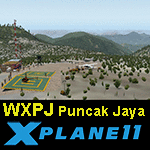
This is an X-Plane 11 scenery for Puncak Jaya Mining Airstrip (WXPJ) in the Puncak Jaya mountain region of Papua, Indonesia. This is a fictitious airfield, located in a high altitute mining location in Papua. At 4884 metres (16024 ft) above sea level, the Puncak Jaya peak, next to the mining location, is the highest mountain in Indonesia, on the island of New Guinea (which consists of the Indonesian West Papua region plus Papua New Guinea). This fictitious airfield may serve as a high altitute mining location challenge while flying the airstrips in Papua, as one of the destinations for "PT ASI Pujiastuti Aviation", operating as Susi Air, an Indonesia airlines established in late 2004 by Mrs. Susi Pudjiastuti. This scenery was tested and is operational (as of January 20, 2017) in "X-Plane 11 Public Beta #6 64 bit", Windows 10 Home. It was also tested and is partially operational (as of January 20, 2017) in "X-Plane 10.51 64 bit", Windows 10 Home. The issue with XP10 is the mesh again: there is no mine mesh, just a whole. The feel is very different from XP11, but it is still operational in XP10 to fly in and out.
| Filename: | WXPJ_Susi_Air_Puncak_Jaya_Mining_Airstrip_v100.zip |
| License: | Freeware |
| Added: | 21st January 2017, 18:42:35 |
| Downloads: | 58 |
| Author: | Rui Mesquita |
| Size: | 2.2 MB |
| Category: X-Plane - Scenery | |
| BR RJ SBME - Macae Airport v1.0.0 |
|
Images related to this file:
File Description:
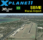
This is an X-Plane 11 and X-Plane 10 scenery package for Benedito Lacerda Airport (IATA: MEA, ICAO: SBME) is the airport serving Macaé, RJ, in Brazil. It includes corrected aprons, ramps, gates, taxiways, lighting system, city buildings, ortho-photoscenery for the airfield area, and (XP11 only) airport ground services (like push back). The airport was established in the 1960s as an airfield for general aviation and a Flying club. In the 1980s the runway was paved and an apron and a terminal with 941 m² were constructed, enabling Macaé Airport to fully support the operations related to the Campos basin (off shore oil platform in the costal area of the state of Rio de Janeiro). In fact, most of its movement (98%) is related to helicopter flights to/from offshore oil platforms of the Campos basin. It features a lot of apron positions for rotorcrafts. This scenery was tested and is operational (as of March 26, 2017) in "X-Plane 11 Public Beta #17 64 bit", Windows 10 Home. It was also tested and is also operational (as of March 26, 2017) in "X-Plane 10.51 64 bit", Windows 10 Home. Only the default X-Plane 11 libraries, by Laminar Research, are needed. No third party libraries are used.
| Filename: | BR_RJ_SBME__Macae_Airport_v100.zip |
| License: | Freeware |
| Added: | 29th March 2017, 03:50:00 |
| Downloads: | 80 |
| Author: | Rui Mesquita |
| Size: | 14.62 MB |
| Category: X-Plane - Scenery | |
| BR ES SBVT - Goiabeiras Vitoria v1.0.0 |
|
Images related to this file:
File Description:

This is an X-Plane 11 and X-Plane 10 scenery package for Eurico de Aguiar Salles Airport (IATA: VIX, ICAO: SBVT), formerly called Goiabeiras Airport after the neighborhood where it is located, which is the airport serving Vitoria metro area, in Brazil. It includes corrected aprons, ramps, gates, taxiways, lighting system, renovation work construction of new runway and new terminal building, the city skyline buildings and (XP11 only) airport ground services (like push back). Located 10 km (6 mi) from downtown Vitória, the airport handles domestic flights only, and has the capacity to receive medium-sized aircraft such as the Boeing 737 and the Airbus 320. It is considered one of the worst among the main airports in Brazil due to lack of renovations. Delayed renovation works have started at the airport, with the construction of a second runway, and a brand new terminal building. This scenery was tested and is operational (as of February 25, 2017) in "X-Plane 11 Public Beta #12 64 bit", Windows 10 Home. It was also tested and is also operational (as of February 25, 2017) in "X-Plane 10.51 64 bit", Windows 10 Home. Only the default X-Plane 11 libraries, by Laminar Research, are needed. No third party libraries are used.
| Filename: | BR_ES_SBVT__Goiabeiras_Vitoria_v100.zip |
| License: | Freeware |
| Added: | 26th February 2017, 08:06:44 |
| Downloads: | 113 |
| Author: | Rui Mesquita |
| Size: | 9.58 MB |
| Category: Flight Simulator 2004 - Scenery | |
| Farallon Island Chain, Version 4 |
|
File Description:
Beta version 4: Combines North, Middle, and Southeast Farallon Islands into one download. Lighthouse added to Southeast Farallon Island along with the water catchment pad (also serves as helipad). These islands were mysteriously absent from the FS2004 default scenery, probably owing to their small size. When I went to look for them I found a small mountain of water instead of the islands. Most people don't seem to be aware of the Farallon Islands. Located off the coast of California, near San Francisco, they are home to thousands of birds, seals, and some of the largest Great White sharks known to man. All of this is within a very short distance of the city. Today, it is a wildlife refuge and is off limits to visitation by the general public. Those of you interested in more info might check out "The Devil's Teeth" by Susan Casey. These islands were created as scenery objects instead of traditional terrain in order to preserve detail. The terrace on the Southeast Farallon Island is landable now but the terrain is pretty rough. If you're in Timberwolf Aviation and you're doing the multiplayer session on 03/26/2006, this is the version you should get.
| Filename: | Farallon_Island_Chain_Version_4.zip |
| License: | Freeware, limited distribution |
| Added: | 26th March 2006, 21:32:24 |
| Downloads: | 1,834 |
| Author: | Glen Gordon (Prof K.) |
| Size: | 1.51 MB |
| Category: Miscellaneous Files - Miscellaneous Files | |
| FSMMoving Map v1.1.0 |
|
File Description:
FSMMovingMap 1.1.0 - Compatible with both FS2002 and FS2004
FSM Moving Map is a Freeware software with some neat features. With proper road maps, you will be able to find your road (or lack of) in FS environment, or fly at ease using Sectional or terminal charts. The concept is very simple: you, the user define all the maps... once you are flying, FSMMM will try to locate the best map available, and display it on screen. This can be very useful during VFR Flights.
One of our beta user has described it as "flying like the rich people with fancy GPS units sporting colour map displays" - 'nuff said.
On local PC, this map can be used with FS2004 Kneeboard, or with "MovingMap Launcher". This software can also integrate with FlightSim Manager (v2.8 and above), and work over the network using FSM Lanview (so you can fly on one machine while the map runs on a different PC).
You can find the latest version from: http://www.ranainside.com/
Programmer
Rana Hossain
[email protected]
24 February 2005
| Filename: | FSMMoving_Map_v110.zip |
| License: | Freeware, limited distribution |
| Added: | 24th February 2005, 05:00:56 |
| Downloads: | 12,057 |
| Author: | Rana Hossain |
| Size: | 798.33 KB |
© 2001-2026 AVSIM Online
All Rights Reserved
Privacy Policy |