
Where Flight Simulation Enthusiasts Gather from Around the World!
AVSIM Library - Search Results

| Category: Flight Simulator 2004 - Scenery | |
| Ulukhaktok (Holman) CYHI in the Northwest Territories, Canada |

|
Images related to this file:
File Description:
Ulukhaktok (Holman) is an airfield on the west side of Victoria Island, off the northern coast of Canada. It is 320 miles west of Cambridge Bay (and you should download and install the recent post of CYCB by Sid and Pete, as I use it for the AI included in this post) and around 400 miles east of Inuvik (my post of a few months ago). It has been officially called Ulukhaktok since 2006, and before that it's name was Holman.
The village of Ulukhaktok has been placed around the bay and is approximately the right shape; it houses some 460 people who used to rely solely on hunting and fishing. The village is close to 71 degrees north, and there are only four months of the year when the average high is above zero centigrade. The photograph with snow (and of course a frozen sea) is typical; for the frozen sea download my Frozen Rivers & Lakes post which will provide this. The buildings on the field have been modelled specifically for this scenery, and as in real life there is only JetA available. The AI visiting aircraft are an Aklak Air DC3 (based in Inuvik and operated by Kenn Borek Air) and a Canadian North Dash 8-100. Note that the runways are signed as "true" headings instead of magnetic; in the Canadian Northern Domestic Airspace all headings are given as true. Unfortunately FS9 doesn't accommodate this in ATC.
| Filename: | Ulukhaktok_Holman_CYHI_in_the_Northwest_Territorie.zip |
| License: | Freeware, limited distribution |
| Added: | 24th May 2011, 20:05:47 |
| Downloads: | 452 |
| Author: | Roger Wensley |
| Size: | 2.3 MB |
| Category: Flight Simulator 2004 - Scenery | |
| Hana Heli-Obstacle Course v3.0 |
|
File Description:
Hana Airport is a regional airport of the State of Hawaii on the east shore of the island of Maui, 3 NM northwest of the unincorporated town of Hana. The airport covers 119 acres and has one runway. It is primarily a commuter facility used by unscheduled air taxis and general aviation. This scenery is intended as a single/multiplayer helicopter obstacle course where heli pilots can meet to compete, show off, and share their helo skills. Since birdseye (Timm Turner) already did a neat scenery called Hana_Scenery_PHHN (search for "hana" in the HoverControl Downloads), we decided to convert PHHN to a full helicopter training area. Makes a great place for helo pilots to gather to practice and perfect their skills, and challenge other pilots! And keep an eye-out for that Hot Air Balloon, cruising around an altitude of 3000 feet (don't forget to wave at them!).
Another unique thing about this scenery is the neighboring islands (Honolulu Intl/Hickam AFB, Bellows AFB, Lanai City, Kahului, Molokai, etc). If you get frustrated during your heli obstacle course training, just take a heading of 275 degrees, and relax at one of the neighboring islands. We also added an Easter Egg - If you set your FS calendar to July 21st, you'll see a large ridge fire up in the hills. Load Jordan Moore's Erickson S64E (http://www.hovercontrol.com/) & try your skills at water bombing!
| Filename: | Hana_HeliObstacle_Course_v30.zip |
| License: | Freeware |
| Added: | 28th August 2011, 17:53:18 |
| Downloads: | 467 |
| Author: | Greg Spellmen, Bob Ferguson |
| Size: | 95.52 MB |
| Category: Flight Simulator 2004 - Scenery | |
| Hana Heli-Obstacle Course v2.0 |
|
Images related to this file:
File Description:
Hana Airport is a regional airport of the State of Hawaii on the east shore of the island of Maui, 3 NM northwest of the unincorporated town of Hana. The airport covers 119 acres and has one runway. It is primarily a commuter facility used by unscheduled air taxis and general aviation. This scenery is intended as a single/multiplayer helicopter obstacle course where heli pilots can meet to compete, show off, and share their helo skills. Since birdseye (Timm Turner) already did a neat scenery called Hana_Scenery_PHHN (search for "hana" in the HoverControl Downloads), we decided to convert PHHN to a full helicopter training area. Makes a great place for helo pilots to gather to practice and perfect their skills, and challenge other pilots! And keep an eye-out for that Hot Air Balloon, cruising around an altitude of 3000 feet (don't forget to wave at them!). Another unique thing about this scenery is the neighboring islands (Honolulu Intl/Hickam AFB, Bellows AFB, Lanai City, Kahului, Molokai, etc). If you get frustrated during your heli obstacle course training, just take a heading of 275 degrees, and relax at one of the neighboring islands. We also added an Easter Egg - If you set your FS calendar to July 21st, you'll see a large ridge fire up in the hills. Load Jordan Moore's Erickson S64E (http://www.hovercontrol.com/) & try your skills at water bombing!
| Filename: | Hana_HeliObstacle_Course_v20.zip |
| License: | Freeware |
| Added: | 7th December 2010, 03:28:47 |
| Downloads: | 475 |
| Author: | Greg Spellmen & Bob Ferguson |
| Size: | 58.56 MB |
| Category: Flight Simulator X - Scenery | |
| VTSM - Koh Samui |
|
File Description:
Today, after almost half a year of construction, I am presenting my new airport to
youVTSM- Samui Airport in front of .......
since I was already there myself and again no decent freeware scenerywas to be
found for the FSX,
so building it yourself was once again the trend
I tested the airport on another computer - everything works fine
Traffic works, Ai traffic as well as road traffic and ILS approach works. So
have fun in Koh Samui at the airport and the surrounding area .......
The best way to go on a voyage of discovery is with a small plane or helicopter so
that you can do the same
see many details .........
lands at the airport VTSM with an A319 or a Boing 737 larger planes are not there
then allowed to take a helicopter or a small plane and fly over the island
explores the many details ...............
Installation:
Put the folder VTSM - Samui in the folder FSX Addon Scenery and activate
Him......... !
The steps listed below only if you don't have these add-ons yet! !
to be able to see people unzip the supplied folder 3dpeoble_Lib and put
the unzipped folder in your FSX Addon Scenery and activate it
Support:
If you have any problems or questions, please send an email to
[email protected]
now have fun and good luck on your flight LG Jamaica
Demo video at https://youtu.be/dcIkSi03sfg?t=7
| Filename: | VTSM__Koh_Samui.zip |
| License: | Freeware |
| Added: | 5th February 2021, 19:28:51 |
| Downloads: | 777 |
| Author: | Ewald Wagner |
| Size: | 52.16 MB |
| Category: Flight Simulator 2004 - Scenery | |
| CNZ3 - Chatham-Kent - Ontario, Canada V1 |
|
Images related to this file:
File Description:
This is partly part of the Small Ontario Fields series. The airport ICAO was changed from CNZ3 to CYCK in November 2012; I have left it as it was. The runway too remains as it was a few years ago. Chatham is located 50 miles east of Detroit and 150 miles southwest of Toronto, between Lake St. Clair and Lake Erie, and the airfield is southeast of the town. There is a single asphalt runway 5,000 feet long and 75 feet wide, aligned 05/23 in FS9 but in fact in real life now 06/24 due to the wandering magnetic north. The apron is on the northern side of the runway at the eastern end, with added taxiways to cater for newer hangars wearing identical colour schemes. There is fuel, runway lighting, some taxiway lights, visitor parking on the grass, and plane maintenance in the large hangar beside the small terminal building on the north side of the apron. There is a train station in the middle of the town, and no scheduled flights to the airport that is 8 miles away; these two facts may be connected. Ditches along the road and around much of the airfield provide separation, which is why the fences are not continuous. If you are on the runway and find your path to the apron blocked by another plane that is stationary at the hold short, continue past the first turnoff to the threshold markers and turn off the runway and wait. The AI plane will then taxi out and you will have a clear path.
| Filename: | CNZ3__ChathamKent__Ontario_Canada_V1.zip |
| License: | Freeware, limited distribution |
| Added: | 27th August 2015, 21:02:59 |
| Downloads: | 341 |
| Author: | Roger Wensley |
| Size: | 9.89 MB |
| Category: X-Plane - Original Aircraft | |
| Boeing B314 Clipper for X-Plane 6.40/6.51 |
|
File Description:
Boeing B314 Clipper v1.0 for X-Plane 6.4/6.51- Built for Pan American Airways to expand their Clipper fleet, they also saw service for the US Navy and BOAC. The "clipper" name was appropriate because the Sikorsky S42, the Martin M130 (also available for X-Plane on AVSIM) and the Boeing B314 opened up long distance air lanes in 1930's and 40's the same way that the clipper ships opened up sea trade in the late 1800's. The model flies very well and is as accurate as the limited plans available to me. Due to limitations in shaping airfoils the outside rudders are actually engine nacelles (jets with 5 lb of thrust) and the lower wing is also an engine nacelle. The rear section of the fuselage is actually a gas tank or float section used to get better detail in the fuselage. As all of my models the exterior paint and panel can use a lot of work. What you see here is approximately 6-8 hours of modelling/decorating? work plus 16-20 hours or more of test flights.
Number built: total 12, 6 A314's built with upgraded engines and increased range
Engines: 4 - 1,600 HP, Wright R-2600, Twin Cyclone ,14 cylinder, air-cooled, radial engines. Wing Span: 152 ft. Length: 106 ft Max GW: 84,000 lb. Max level speed: 193 mph Cruising speed: 183 mph Range: 3,500 (5,200 A314) miles First flight: June 7, 1938, last retirement 1951. Ceiling: cruise 13,400, maximum 19,600 feet
Accommodation: 10 crew, 74 (36 night) passengers.
| Filename: | Boeing_B314_Clipper_for_XPlane_640651.zip |
| License: | Freeware |
| Added: | 12th February 2003, 22:41:20 |
| Downloads: | 639 |
| Author: | Robert App |
| Size: | 1.06 MB |
| Category: Miscellaneous Files - Demos from Commercial Vendors | |
| Greece Airforce McDonnell Douglas F-4F Phantom II |
|
Images related to this file:
File Description:
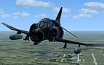
The McDonnell Douglas F-4 E/F Phantom 2 is a two-seat, twin-engined, all-weather, long-range supersonic fighter-bomber originally developed for the U.S. Navy by McDonnell Aircraft. Proving highly adaptable, it became a major part of the air wings of the U.S. Navy, Marine Corps, and U.S. Air Force. It was used extensively by all three of these services during the Vietnam War, serving as the principal air superiority fighter for both the Navy and Air Force, as well as being important in the ground-attack and reconnaissance roles by the close of U.S. involvement in the war.
First entering service in 1960, the Phantom continued to form a major part of U.S. military air power throughout the 1970s and 1980s, being gradually replaced by more modern aircraft such as the F-15 Eagle and F-16 Fighting Falcon in the U.S. Air Force and the F-14 Tomcat and F/A-18 Hornet in the U.S. Navy. It remained in service in the reconnaissance and Wild Weasel roles in the 1991 Gulf War, finally leaving service in 1996. Phantoms remain in front line service with seven countries, and in use as an unmanned target in the U.S. Air Force. Phantom production ran from 1958 to 1981, with a total of 5195 built. This extensive run makes it the second most-produced Western jet fighter, behind the famous F-86 Sabre at just under 10,000 examples.
Panel, GAUGES, model, sound and textures by www.afs-design.de - Author: A.Meyer.
| Filename: | Greece__Airforce_McDonnell_Douglas__F4F_Phantom_II.zip |
| License: | Commercial demo |
| Added: | 18th July 2010, 08:21:59 |
| Downloads: | 168 |
| Author: | Andreas Meyer |
| Size: | 3.22 MB |
| Category: Flight Simulator 2004 - Scenery | |
| Dixie A05 Forest Service airfield in Idaho USA |
|
Images related to this file:
File Description:
This airfield is in the mountains of Idaho, the first in a series. There are not many mountain airfields that can be succesfully modelled in FS9 because the FS9 terrain does not always match reality; no creek for instance, or the valley too small. There are others where the grass strip is all there is, so there is nothing to model apart from resizing the cleared area. Some are well known, well maintained, have clean shower facilities, and are well used for a weekend by small planes with two people and a tent on board, for instance Johnson Creek. Others are less well known but still in good condition, such as Dixie or Big Creek. And there are also some with cabin rental facilities, such as Sulphur Creek Ranch. Other names come to mind, such as Flying B and Pistol Creek, but unfortunately for one reason or another these could not be made. The other difficulty involving hills is succesful AI landings and take offs. At Johnson Creek, for instance, the wind should be from the south to make AI landings more likely to succeed. Dixie is south of the village of the same name, and not to be confused with the dirt strip that is just beside the village. The runway is at 5,148 feet ASL, just over 4,000 feet long and aligned 18-36, and the parking area is at the northern end, opposite the Forest Service buildings. There is a chart of the area included, and to the south of Dixie is the next in the series, Big Creek U60.
| Filename: | Dixie_A05_Forest_Service_airfield_in_Idaho_USA.zip |
| License: | Freeware, limited distribution |
| Added: | 25th May 2017, 17:53:48 |
| Downloads: | 153 |
| Author: | Roger Wensley |
| Size: | 8.69 MB |
| Category: Flight Simulator 2004 - Scenery | |
| Big Creek U60 public use airfield in Idaho USA |
|
File Description:
This airfield is in the mountains of Idaho, 30 miles south of Dixie A05, which was the first in the series to be posted. Big Creek is now regularly used for picnic fly-ins and overnight camping, or for just a day of fishing in the creek; the creek does not appear in FS9 as it is not exactly huge, and within the Ultimate Terrain USA settings I have in fact turned streams off as in some cases they cross the grass or (in conjunction with the roads) left insufficient runway space. The U60 runway is at 5,743 feet ASl, 3,550 feet long, aligned 01-19, and in good condition. At the southern end there is the new replica of the old original Big Creek Lodge which was built in 1935. This burned down in 2008, and is now being rebuilt by a group of pilots, pilots having formed a large part of the early clientel courtesy of the grass strip. It is shown here as still under construction. There are also Forest Service buildings on the west side of the runway. All of this is located in the Frank Church Wilderness area and the Payette National Forest. The AI is increased at the weekends, reflecting reality, and also revised to use Boise as one of the starting places. Dixie is also reissued here with a revised positioning to fit with the roads. I had concluded that the roads were wrong, while in fact the position of the airstrip was at fault.
| Filename: | Big_Creek_U60_public_use_airfield_in_Idaho_USA.zip |
| License: | Freeware, limited distribution |
| Added: | 25th May 2017, 17:53:58 |
| Downloads: | 132 |
| Author: | Roger Wensley |
| Size: | 11.06 MB |
| Category: Flight Simulator 2004 - AI Flight Plans | |
| TUI Airlines Belgium Winter 04-05 (version 2) |
|
File Description:
FS2002/2004 "TUI Airlines Belgium" representative charter flight plans for the winter 2004-2005 period, which have been compiled according to the company information for the week 07 Mar 2005 - 13 Mar 2005.
This version is an UPDATE of my previous release due to the arrival of their own Boeing 767-300ER.
TUI Airlines Belgium (TUB) is a charter airline based in Belgium, flying with three 737-400, two 737-800W, and one 767-300ER from its main base Brussels-National as well as from regional airports of Liège and Oostende.
As for all charter company, flights differs from one week to one another but this file comprises its main destinations regularly visited throughout the winter period.
The TUB winter season flights comprises both medium- and long-haul destinations from Brussels, Liège and Oostende-Brugge to Agadir, Alicante, Almeria, Cancun, Djerba, Faro, Fuerteventura, Hurghada, Lanzarote, Las Palmas, Luxor, Malagà, Marrakech, Monastir, Montego Bay, Pafos, Palma de Mallorca, Puerto Plata, Punta Cana, Santa Cruz (La Palma), Sharm el Sheikh, and Tenerife-Sur, and Varadero.
As from spring 2005, TUB will launch scheduled services to Agadir, Cairo, Marrakech, Tanger, Toulon, as well as new charter flights to Ajaccio, Bastia, Marsa Alam, Funchal, plus many other charter destinations to Bulgaria, Croatia, France, Greece, Italy, Spain, Tunisia and Turkey. Also, a new aircraft type will be introduced in the fleet in the form of the Fokker 100 ::: stay tuned for summer season flightplans release :::.
Schedule files fully compatible with Traffic Tools by Lee Swordy (available on this site).
| Filename: | TUI_Airlines_Belgium_Winter_0405_version_2.zip |
| License: | Freeware |
| Added: | 5th March 2005, 22:30:32 |
| Downloads: | 1,060 |
| Author: | Jean-Philippe DELWICHE |
| Size: | 7.31 KB |
© 2001-2026 AVSIM Online
All Rights Reserved
Privacy Policy |