
Where Flight Simulation Enthusiasts Gather from Around the World!
AVSIM Library - Search Results

| Category: Flight Simulator X - Scenery | |
| CYQQ (2010) Version 2 for FS9, FSX and Prepar3D |

|
Images related to this file:
File Description:
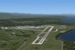
CYQQ (2010) portrays Canadian Forces Base Comox (Vancouver Island, British Columbia, Canada) (CYQQ), the Comox Valley Air Terminal and surrounding area. It is fully compatible with Ultimate Terrain Canada/Alaska for FS2004, Ultimate Terrain X - Canada for FSX and ORBX's FTX NA Blue. CYQQ (2010) includes over 100 "hand-crafted" buildings and other structures and 10 different vintage aircraft on static display, as well as aircraft and traffic files for a realistic AI scenario that causes a variety of military aircraft that come and go. (Use BC Regional AI - also available from this file library - for scheduled traffic.) Civilian AI is now routed so as not to transit military aprons.
Aside from the new approach lighting, generally, this new version is visually identical to its predecessor - even though quite different internally. As well, to the extent possible, it is compatible with Prepar3Dv2.
| Filename: | CYQQ_2010_Version_2_for_FS9_FSX_and_Prepar3D.zip |
| License: | Freeware, limited distribution |
| Added: | 20th June 2014, 11:39:47 |
| Downloads: | 11,036 |
| Author: | Don Grovestine |
| Size: | 33.19 MB |
| Category: Flight Simulator 2004 - Scenery | |
| Central Europe 1961 |
|
Images related to this file:
File Description:

This scenery package contains twelve airports in Germany, nine in the Netherlands, one in Luxembourg, three in Switzerland , and three in Austria - providing taxiways and details as they were at the beginning of the 1960's.
We also created the harbors of Rotterdam, Hamburg and Den Helder, all the lighthouses along the Dutch coast and some along the German coast, and created the island of Helgoland from scratch. Although most of the airports of the package are for civil use, we also produced some Dutch military bases with AI and static aircraft. At many of the airports you will find moving crash tenders and at Amsterdam moving airport buses. Although we did not always have enough photos and information we tried to come as close as possible. Our goal was to reflect something of the atmosphere and feel of that period, prior to the all-jet era of today.
| Filename: | Central_Europe_1961.zip |
| License: | Freeware, limited distribution |
| Added: | 17th May 2013, 20:07:54 |
| Downloads: | 6,646 |
| Author: | Wolfgang Gersch, Harry Biard, Michael Schneider,Jaap de Baare, Nikko Yaginuma, Tom Gibson, Bernard Leuenberger and Mike Stevens |
| Size: | 55.23 MB |
| Category: Flight Simulator 2004 - Scenery | |
| Kerkira Airport Enhancement |
|
File Description:
This is old scenery which has been updated for FS2004 and enhances the visual environment of Ionian sea island airport of Kerkira, also known as Corfu. Its part of my “Greek Airfields” package that currently is not fully compatible with FS2004 since MS decided to move the airports in Greece and elsewhere to adjacent positions and ASD, which I use for placing these objects, is not compatible with FS2004. Here you will find airport & terrain enhancements for Hellenic airport of Kerkira LGKR that make it look closer to the real one; hotels, runway turning bay, perimeter fences, windsocks, radio antennae, new approach radar antenna to the southwest and most importantly, an exclusion of autogen scenery that is wrongfully generated on each side of the runway. A big difference is attributed to Babis Peribolas’s Kerkira mesh terrain that is included in this scenery. Scenery includes the necessary ASD 2.1 textures.
| Filename: | Kerkira_Airport_Enhancement.zip |
| License: | Freeware, limited distribution |
| Added: | 4th September 2003, 02:23:06 |
| Downloads: | 12,174 |
| Author: | Kyprianos Biris |
| Size: | 1.94 MB |
| Category: Prepar3D V5 - Aircraft Repaints, Textures and Modifications | |
| Captain Sim B767-II Varig Airlines PP-VOI |
|
Images related to this file:
File Description:
Enclosed is a Varig (PP-VOI) repaint for the Captain Sim B767-II with the GE Expansion. This repaint was built in P3D v5.2.
This particular aircraft, PP-VOI (SN 24752), is a GE CF6-80C2B6 powered variant and was delivered new from Boeing to Varig (Viação Aérea Rio-Grandense) Airlines on December 12, 1989.
The relatively new ETOPS-120 certification was first awarded for TWA's B762's in May 1985 with ETOPS-180 certification for GE equipped B767's approved in 1989 through the demonstrated reliability and the continued confidence from the design of this long haul, wide bodied, twin engined aircraft.
PP-VOI was the first of sixteen B767-300's delivered that, along with the new fleet of MD11's, were intended to support Varig's long haul network and replace the aging, expensive, and limited numbers B747-300 fleet, with plans of further route expansion.
She was adorned from delivery with the "classic/retro" paint scheme seen here, which was prominent for Varig Airlines between 1961 and 1996. VOI served both scheduled and chartered North American, South American and Trans-Atlantic International Routes in this livery from Varig's bases in Rio de Janeiro (SBGL) and Sao Paulo (SBGR) for almost a dozen years before being repainted in the "newer" 1996 design scheme.
This particular airframe continued to serve Varig Airlines (once Brazil's Flag Carrier) until that airline's unfortunate split/financial restructuring into Flex Linhas Aéreas and Gol Airlines in 2006, continuing to fly charter routes for Flex until 2010.
Between 2010 and 2015, this airframe went on to be leased to Business Air Thailand continuing to fly passenger charter revenue flights under registration HS-BIC.
As of December 2021, this particular airframe continues to fly freight (an ERBDSF conversion) since 2016 for Kalitta Airways under contract to DHL as registration N761CK.
Hope you enjoy the photos and the brief history of this particular B767-341ER!
Note: This repaint was completed for the CS B767-II with the GE Expansion.
| Filename: | Captain_Sim_B767II_Varig_Airlines_PPVOI.zip |
| License: | Freeware |
| Added: | 17th December 2021, 17:11:16 |
| Downloads: | 65 |
| Author: | Rob Meier |
| Size: | 95.12 MB |
| Category: Flight Simulator 2004 - Scenery | |
| PAEN, PAEX, 3AK4, 30AK, 52AK - Alaska, USA |
|
Images related to this file:
File Description:
The town of Kenai is on the east coast of Cook Inlet, 60 miles southwest of Anchorage. The airport is in the northern part of the town, with a runway aligned 1-19, 7,550 feet long and 150 feet wide (with an ILS on 19). A second runway is gravel, 2,000 feet long and for winter use by ski planes. There is also a water runway, and all three are aligned the same and called "1 left-19 right" (the main runway) "1 right-19 left" (gravel) and "1 water-19 water". The taxiways are extensive and designed for a far larger traffic than the airport has today, though even now the airport is fairly busy. In FS9 a water runway for AI cannot work with an ATC control tower; the water part of PAEN has therefore been separated into another call sign PAEX which has ONLY the water runway; the tower will therefore direct the plane that makes contact to use the water runway. The PAEN airport runway has taxiway connections at each end and also two intermediates; at the northern end there are in fact two so a total of 5; B, C, D, E, and F; there is an airport diagram included. GA traffic goes to one of two parking aprons, both at the southern end, and at the far southern end there is the hangar for the Civil Air Patrol. The AI includes aircraft from my previous Alaska posts, as Kenai is where I sent them when they departed from, for instance, Palmer. Airlines and cargo companies that operate from and to Kenai are included in the AI: ERA (which has recently changed it's name), Grant Aviation, Air North, Wings of Alaska, North Star Air, and a small local company Air Supply Alaska, along with Fedex, UPS, Everts, and Northern Air Cargo. There is also GA and float AI. Nearby smaller airfields are included, partly because one of them was dramatically misaligned in FS9.
| Filename: | PAEN_PAEX_3AK4_30AK_52AK___Alaska_USA.zip |
| License: | Freeware, limited distribution |
| Added: | 26th December 2015, 15:33:19 |
| Downloads: | 482 |
| Author: | Roger Wensley |
| Size: | 23.08 MB |
| Category: Flight Simulator 2004 - Scenery | |
| Bethel area airfields in southwest Alaska close to the Yukon River |
|
Images related to this file:
File Description:
This presumes you have already installed my post of Bethel PABE. In the Yukon River area of Alaska there are a lot of small villages close together, which is unusual for Alaska. Almost all of them are on the coast or a river bank, and the local economies depend on fishing. Some are larger than others and have a fish processing plant, such as in Emmonak. This is the largest such plant and it exports prepared fish by cargo planes which fly in on a daily basis, using an extended runway. This post includes airfields to the south and west of PABE, 17 of them; some of them already included and now modified. There will be more airfields to the north and northwest of Bethel in a future post. There are revisions to Bethel to include parking spaces for Yute Air (newly included here) and extra spaces for Ryan Air. Both of these flew Cessna 205 planes into the smaller village strips from Bethel (past tense as Yute Air recently went bankrupt). The northwest area is served both from Bethel and also from St Mary's PASM, which is in the northwest and at a more economical range to the local airfields (100 miles closer than Bethel). These smaller airfields have few airfield buildings or any other creature comforts; featuring heavily are a new standard blue garage building (sometimes not yet installed) and a small and old terminal shed (that has sometimes collapsed and been removed). Go to "http://vfrmap.com/" for free vfr maps of the area, There is a pic of the local chart area included here. The screenshots are a random sample. Kipnuk PAKI is the one that appears to have a second and long grass runway; what it actually has is the ground prepared for a new and long gravel runway but which hasn't been started yet as it has taken 10 years just to prepare the ground. I have no idea why.
| Filename: | Bethel_area_airfields_in_southwest_Alaska_close_to.zip |
| License: | Freeware, limited distribution |
| Added: | 16th April 2019, 22:47:47 |
| Downloads: | 154 |
| Author: | Roger Wensley |
| Size: | 5.93 MB |
| Category: Flight Simulator 2004 - Scenery | |
| PAKN - King Salmon - Alaska, US V1 |
|
Images related to this file:
File Description:
This is the final version, complete in itself and incorporating the two modifications posted separately. King Salmon is a town with a population of just under 400, on the north bank of the Naknek River and 15 miles from the sea. The airport is adjacent to the town and was originally an airforce base; the military hangars on the airport are still usable. The airport, with its long runway (11-29 and 8,500 feet with an ILS, and a second runway 18-36 and 4,000 feet) is a transportation hub for the area in general and in particular for the salmon industry. Along the Naknek River there are numerous canneries and there are also fishing lodges on the river and nearby lakes; to speed up transportation to the lodges there are float bases on the river to the south of the airport. King Salmon has three tiers of scheduled flights: Alaska Air direct from Anchorage in a 737 (passengers and cargo), PenAir (Saab turboprop) as part of their flights up and down the peninsula, and Grant Air serving nearby small towns. There are also PenAir flights, both scheduled and unscheduled, in smaller aircraft (Piper Navajo for instance) to smaller airports for the fishing season, plus cargo flights in larger aircraft by the lowest bidder (Everts and Northern). To complete the mix the AI includes a pair of F15s. The runways cross (see the airport diagram) so read the notes re long taxi routes. There is AI for PAKN, plus revised AI made for Dutch Harbor which includes flights by PenAir to King Salmon, plus revised parking for Dutch Harbor with new replacement bgls to cater for more flights. There is also AI for the float bases on the river; I have made two runways separated into two float bases for river AI, called King Salmon Floats and King Salmon River; more AI for these will be added when other scenery along the river is made. Just land according to the wind and taxi to whatever dock takes your fancy.
| Filename: | PAKN__King_Salmon__Alaska_US_V1.zip |
| License: | Freeware, limited distribution |
| Added: | 11th April 2015, 06:20:40 |
| Downloads: | 502 |
| Author: | Roger Wensley |
| Size: | 23.67 MB |
| Category: Flight Simulator 2004 - Scenery | |
| Coal Harbour CAQ3 float base in British Columbia, Canada |
|
Images related to this file:
File Description:
This is number eight in a series of new and renovated float bases in BC. Coal Harbour is in a sheltered cove off Holberg Inlet on the northwest coast of Vancouver Island, close to the village and 10 miles southwest of the Port Hardy float base. There is 100LL fuel and oil available. Due to the deep fjords that run into Vancouver Island from the west coast Coal Harbour is actually closer to the east coast than it is to the west coast. The tortuous route in through Quatsino Sound and Rupert Sound shelters the waters of Holberg Inlet from the stormy seas of the west coast, and fishing boats take advantage of this. The floatplane dock is to the south of the large (and old) hangar, adjacent to the southern end of the fixed dock where the ramp bridge descends to the floating docks. The video makes it clearer. The AI is a further adaptation of the CF36 AI and involves Beavers and Otters as listed in the AI folder. Due to the surrounding hills there may be some interference with AI aircraft, depending on the wind direction, though I have watched succesful Beaver and Otter landings. Amid the hills there is a very large hole in the ground to the east. The village name suggests it may have been for coal but though in fact there was a coal mine, that was a much smaller and unsuccesful venture; this particular scene of enthusiastic digging was for copper, until 1996. The main claim to fame of Coal Harbour was that it was the last whaling station in North America, using the buildings that were part of the RCAF float plane patrol base during WW2. One downloader reported a texture problem with Port McNeill, to which we found a solution. As he was the only person to email me I am going to presume that nobody else had the problem.
| Filename: | Coal_Harbour_CAQ3_float_base_in_British_Columbia_C.zip |
| License: | Freeware, limited distribution |
| Added: | 25th January 2017, 00:29:05 |
| Downloads: | 225 |
| Author: | Roger Wensley |
| Size: | 7.79 MB |
| Category: Flight Simulator X - Scenery | |
| RAF Manston 1944 |
|
File Description:
RAF Manston (ICAO EGMH)was an RAF station in the north-east of Kent, on the Isle of Thanet from 1916 until 1996. The site is now split between a commercial airport Kent International Airport (KIA) and a continuing military use by the Defence Fire Training and Development Centre (DFTDC), following on from a long-standing training facility for RAF firefighters at the Manston base.
Source: Wikipedia
I have represented it here in 1944 leading up to its part in Operation Market garden and D Day. It was one of the few airfields installed with the Fog Investigation Dispersal Organisation (FIDO) system designed to remove fog from airfields by burning it off with petrol and I have represented this with the 8 fuel tanks at the 29 end of the mail runway. I have laid the station out roughly according to an old map made in the mid 40s but I make no claims to the accuracy of building I have used.
| Filename: | RAF_Manston_1944.zip |
| License: | Freeware |
| Added: | 26th April 2016, 00:15:35 |
| Downloads: | 160 |
| Author: | Terry Boissel |
| Size: | 1.71 MB |
| Category: Flight Simulator X - Scenery | |
| RAF Ludford Magna |
|
File Description:
RAF Ludford Magna was a Royal Air Force airfield operated by Bomber Command during the Second World War and the Cold War. The station lay on agricultural farmland immediately south of the village of Ludford, Lincolnshire and was sited 21.4miles (34.4 km) north east of the county town of Lincoln, Lincolnshire, England. The remains of the station can be seen from the B1225 Caistor High Street, and the long distance footpath the Viking Way passes right next to the eastern perimeter track.
It was the highest bomber airfield in England at 428 feet (130 m) above sea level, and cost £803,000 to build.
All credit must go to the following authors without whose work I could not have made this scenery; all credit for the models contained in it is theirs I merely placed it. If you don't have any of the third party addons you will only see the runway and peri track: Ted Andrews - Ian Pearson - Mike Hudson
| Filename: | RAF_Ludford_Magna.zip |
| License: | Freeware |
| Added: | 5th October 2015, 20:07:32 |
| Downloads: | 339 |
| Author: | Terry Boissel |
| Size: | 20.9 KB |
© 2001-2026 AVSIM Online
All Rights Reserved
Privacy Policy |