
Where Flight Simulation Enthusiasts Gather from Around the World!
AVSIM Library - Search Results

| Category: Flight Simulator 2004 - Scenery | |
| Dragon Peaks AFB, South Africa |

|
Images related to this file:
File Description:
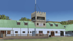
A Gmax representation of Dragon Peaks Air Force Base also referred to as CL van Wyngaard Airfield, South Africa with photoreal textures.
AFB Dragon Peaks is a small airfield nestled between the hills on the slopes of the Northern Drakensberg of South Africa. The airfield is situated only a few hundred meters from the Dragon Peaks Mountain resort as well as the home of the famous Drakensberg Boys Choir.
The grass runway is aligned 06/24 and 458m long and sits at an elevation of 3 986ft.
The scenery consists of 64 square kilometers of photoscenery with variants for all 4 seasons. Almost 1 100 hand placed autogen buildings and more than 32 000 (yes, thirty-two-thousand) hand placed autogen trees makes up the surrounding scenery. At the airfield itself you will find custom made Gmax models of the airfield buildings and structures with photoreal textures.
| Filename: | Dragon_Peaks_AFB_South_Africa.zip |
| License: | Freeware, limited distribution |
| Added: | 9th November 2017, 18:36:39 |
| Downloads: | 464 |
| Author: | kobus van wyk |
| Size: | 19.94 MB |
| Category: Flight Simulator 2004 - Scenery | |
| Kasba Lake CJL8 Northwest Territories Canada |
|
Images related to this file:
File Description:
This is a sixth airfield with links to Lake Athabasca, which is in Alberta and Saskatchewan. Kasba Lake is some 135 miles northeast of Stony Rapids and is in the Northwest Territories. The airfield is owned and run by and for Kasba Lake Lodge and it is one of several fishing vacation spots that are serviced by flights from Stony Rapids. It is these flights to the north that explain the number of regular scheduled flights into Stony Rapids from the south. The Kasba Lake Lodge has docks for boats and also for clients that want to arrive in their own floatplanes. The ai is for both Kasba Lake and Obre Lake and replaces the porpoising plane that I had used for Obre Lake. Norilor flies the weekend package-deal-long-distance delivery flights for Kasba Lake direct from Winnipeg, and now also for Obre Lake.
| Filename: | Kasba_Lake_CJL8_Northwest_Territories_Canada.zip |
| License: | Freeware, limited distribution |
| Added: | 9th August 2018, 14:21:17 |
| Downloads: | 149 |
| Author: | Roger Wensley |
| Size: | 2.48 MB |
| Category: Flight Simulator 2004 - Scenery | |
| Fort Graham CBW3 in British Columbia Canada |
|
Images related to this file:
File Description:
Fort Graham is what looks like a very small village on the eastern shore of Williston Lake in northern British Columbia, around 100 miles north of Mackenzie (a previous post). The lake, while not large by Canadian standards, is well over 100 miles long but squeezed in width to a maximum of 5 miles amid the surrounding Rockies. The airfield has a gravel runway of 5,000 feet aligned 13-31 and at 2,230 feet ASL. There is no lighting. The operator of the airfield (and presumably the "village" too) is Finlay River Outfitters, a company that is based in Mackenzie and "outfits" hunting trips in the local area. I have posted this as Fort Graham CBW3, but I suggest that you just add it to your previously created "BC airfields" and avoid the inevitable doubling up of common textures etc. Up to you. If you find a defect, email me.
| Filename: | Fort_Graham_CBW3_in_British_Columbia_Canada.zip |
| License: | Freeware, limited distribution |
| Added: | 23rd November 2020, 20:13:11 |
| Downloads: | 106 |
| Author: | Roger Wensley |
| Size: | 7.75 MB |
| Category: Flight Simulator 2004 - Scenery | |
| Snowden Farm CF39, in Ontario Canada |
|
Images related to this file:
File Description:
Another airfield close to Highway 11, further south towards Lake Simcoe. Snowden Farm is a bit over five miles south of Huntsville and east of of highway 11. The grass runway 12/30 is just over 2,000 feel long and sandwiched between Penfold Lake to the north, and on the south side a large pond with a creek that connects to the much larger Mary Lake to the east. There is a hangar and a shed at the eastern end of the runway. There is one airfield scenery file, and two landclass files to provide the grassed area and the large pond and creek. I presume that the pond was just a little too small to register with Ultimate Terrain. The scenery might work without Ultimate Terrain but I haven't tested it, and for sure without it Penfold Lake and probably Mary Lake won't appear.
| Filename: | Snowden_Farm_CF39_in_Ontario_Canada.zip |
| License: | Freeware, limited distribution |
| Added: | 5th February 2010, 03:51:07 |
| Downloads: | 296 |
| Author: | Roger Wensley |
| Size: | 837.43 KB |
| Category: Flight Simulator 2004 - Scenery | |
| WION Ranai, Indonesia |
|
File Description:
Googly scenery for Ranai, a domestic airport located on Natuna Besar,
the main island of the 272 islands comprising the Natuna archipeligo in
Indonesia. The airport is served by daily flights of Riau Airlines using
Fokker 50 turboprop aircraft.
Flight Simulator 2004 has only provided a runway at this airport and this scenery
seeks to redress the situation so that you and your "AI" traffic can use the
airport.
The scenery does not purport to be ultra-accurate. Based on high quality
satellite imagery from Google Earth, the layout is proportionally correct but the
added airport features, such as buildings, are built from default Microsoft objects
and add-on libraries so will not look exactly like the real thing.
You are not obliged to download and install any additional scenery libraries,
but to enjoy this scenery in its entirety, you may wish to. It will work fine,
with or without.
| Filename: | WION_Ranai_Indonesia.zip |
| License: | Freeware |
| Added: | 11th October 2008, 13:12:55 |
| Downloads: | 1,242 |
| Author: | John Hinson |
| Size: | 60.07 KB |
| Category: Flight Simulator X - AI Flight Plans | |
| Sky Regional - Summer 2018 |
|
Images related to this file:
File Description:

Current flight plan of Sky Regional for summer 2018.
Sky Regional Airlines is an airline whose corporate headquarters is on the property of Toronto Pearson International Airport, Mississauga, Ontario, Canada. Linked with Skyservice Business Aviation, it began operation under the Air Canada Express brand on May 1, 2011. The airline began offering daily flights between Toronto Island and Montréal–Pierre Elliott Trudeau International Airport.
Sky Regional introduced a fleet of Embraer 175 jets in March 2013 to serve US destinations such as New York, Newark, Boston, Philadelphia, Chicago, and Dallas/Fort Worth.
Between October and December 2015 the fleet of 20 was expanded to 25 after obtaining 5 additional Embraer 175 previously operated by Azul Brazilian Airlines. These aircraft were put into service in April 2016 allowing the airline to add routes to more US destination such as Denver International Airport, and Hartsfield-Jackson Atlanta International Airport.
| Filename: | Sky_Regional__Summer_2018.zip |
| License: | Freeware |
| Added: | 12th August 2018, 19:31:54 |
| Downloads: | 262 |
| Author: | Frank Drebing |
| Size: | 26.07 KB |
| Category: Flight Simulator 2004 - Scenery | |
| Argyle International Airport, Saint Vincent |
|
Images related to this file:
File Description:
This is a scenery created by me of the soon to be completed Argyle International Airport on the island nation of Saint Vincent and the Grenadines. This scenery was created as a pet project of mine out of personal love for the project. The airport was created using only default scenery objects and the only thing that was changed was the type and direction of the turning point at the RWY04 end. I'm sharing this so FS2004 simmers can see what the airport will be like on completion. The scenery is 100% customizable to suit your preference. All I ask is that you don't change the actual airport design. I hope that this will bring you hours and hours of flying fun.
Important: This scenery requires the full RWY12 Scenery Library including the Gate Markings SS files. Also the Lesser Antilles Mesh is required.
| Filename: | Argyle_International_Airport_Saint_Vincent.zip |
| License: | Freeware |
| Added: | 22nd December 2013, 21:57:40 |
| Downloads: | 528 |
| Author: | Cilbert Campbell |
| Size: | 6.8 KB |
| Category: Flight Simulator X - Scenery | |
| FIMP - Sir Seewoosagur Ramgoolam Intl - Mauritius *New Terminal & Airport Layout* |
|
Images related to this file:
File Description:

This scenery adds the new terminal and taxiways, and rebuilds the aprons and runway to provide a fully functioning AI traffic extension for runway 14. The airport is assigned a mean elevation, allowing it to blend naturally with the surrounding terrain, and landclass is provided for the entire island. This scenery is most effective when used in combination with "mauritius_fsx.zip" by Max Kraus. This scenery is optimized to fit seamlessly with FTX Global/Vector and should also be fully functional in all FSX configurations. The airport is updated to reflect current satellite imagery and positioning. Scenery was created using Airport Design Editor X v1.61.5298, SBuilderX 3.13, and the FSX Object Placement Tool. Scenery objects were added and modified from stock FSX scenery to resemble as closely as possible the actual airport. The FSX apron lights included are from the set created by Jim Dhaenens.
| Filename: | FIMP__Sir_Seewoosagur_Ramgoolam_Intl__Mauritius_Ne.zip |
| License: | Freeware |
| Added: | 10th July 2015, 16:16:40 |
| Downloads: | 8,786 |
| Author: | Carlyle Sharpe |
| Size: | 5.06 MB |
| Category: Flight Simulator 2004 - Scenery | |
| Coromandel Photoscenery Compilation *updated* |
|
File Description:
This is a compilation of the various addons developed for the Coromandel region of the North Island, New Zealand.
The basis of this scenery is the simply stunning Godzone Photoscenery developed by Robin Corn and the autogen created for it by Ian Warren. Their combined efforts have produced a wonderfully beautiful and realistic scenery for VFR flying. Lawrie Roache has produced some simply stunning renditions of the airports in the Coromandel area -
Thames (NZTH), Coromandel (NZCX), Pauanui Beach (NZUN), and Whitianaga (NZWT), which were created specifically to fit with the Coromandel Photoscenery by Robin Corn. Charl du Toit has finished and perfected the area with his adjustments to the photo-terrain.
This is simply a compilation (with permission) and re-release of the many fine sceneries these men have produced.
This updated version includes a newer version of the photoscenery and some bug-fixes.
| Filename: | Coromandel_Photoscenery_Compilation_updated.zip |
| License: | Freeware, limited distribution |
| Added: | 5th October 2012, 02:42:03 |
| Downloads: | 820 |
| Author: | Robin Corn, Ian Warren, Lawrie Roache, Charl du Toit, Ephram Matheson |
| Size: | 52.28 MB |
| Category: Flight Simulator 2004 - Scenery | |
| Honolulu International Airport PHNL |
|
File Description:
This scenery completely redoes the Honolulu Airport, which is the main stop over between the East and West, and the largest airport in the Central Pacific. Included here you will find the main terminal, the Inter-Island terminal, fuel storage tanks, 39 gates with jetways, plus numerous other parking spaces, three different hangar / cargo areas, parking structures and the park like landscaping on the front side of the airport, realistic ramp lights, ramp light parking textures, airport vehicles, the Aloha Tower, and the numerous Coconut Palms which welcome you at every turn at this airport. Due to it's large size, I have provided two scenery density settings, so you can eliminate all objects in front of the airport which are not seen from airside, and balance it between traffic and scenery density to get the best frame rates on your particular computer. This scenery should also be completely compatible with FS2002.
| Filename: | Honolulu_International_Airport_PHNL.zip |
| License: | Freeware |
| Added: | 10th December 2003, 04:56:16 |
| Downloads: | 42,315 |
| Author: | Bill Melichar |
| Size: | 4.91 MB |
© 2001-2026 AVSIM Online
All Rights Reserved
Privacy Policy |