
Where Flight Simulation Enthusiasts Gather from Around the World!
AVSIM Library - Search Results

| Category: Flight Simulator 2004 - Aircraft Repaints, Textures and Modifications | |
| US Navy Boeing P-8A Poseidon (314) |

|
Images related to this file:
File Description:
TDS Boeing P-8A Poseidon VP-46 "Grey Knights" - Patrol Squadron Four Six (VP-46), also known as the "Grey Knights", is a maritime patrol squadron of the United States Navy based at Naval Air Station Whidbey Island, Washington. Part of Patrol and Reconnaissance Wing Ten, VP-46 is the oldest maritime patrol squadron and the second oldest aircraft squadron in the entire U.S. Navy, second only behind VFA-14. All P-3 Orion Squadrons are due to have the P-3 Orions replaced by 2019 with the the P-8A Poseidons. Budget cuts not withstanding. This is not fictional but instead my rendering of what it may look like. Model design by Hiroshi Igami. Flight dynamics design by Nick Wilkinson and David Biggar. Master textures by Kyle Schurb.
| Filename: | US_Navy_Boeing_P8A_Poseidon_314.zip |
| License: | Freeware, limited distribution |
| Added: | 15th April 2015, 01:10:00 |
| Downloads: | 262 |
| Author: | Danny Cummings |
| Size: | 6.8 MB |
| Category: Flight Simulator 2004 - Scenery | |
| San Marteen Trees 2013 |
|
Images related to this file:
File Description:

Dear Friends simmer, what is one of the most beautiful landings of the world? Obvious: St. Maarten Princess Juliana! I noticed some time watching videos of the real approaches on TNCM, there aren't something to complete the complexity of the scenery of fs 2004: the density of the trees on the left side of the island. with this scenery, I wanted as much as possible, increment the realism of default scenery San Marteen fs 2004 using bgl of 'friend Gianluca Giovannini. Down the lane I also tried to increase the number of houses in the village over the Sympsoon Bay Lagoon to make the takeoff view more pleasing , Needless to say, the effect with the scenery fly tampa (payware) is really better.
Happy Flights and greetings from Italy, Fabio "fafoair" ferrari, Castione Presolana Bergamo.
| Filename: | San_Marteen_Trees_2013.zip |
| License: | Freeware |
| Added: | 1st March 2013, 07:17:19 |
| Downloads: | 2,314 |
| Author: | Fabio Ferrari "fafo air" |
| Size: | 3.07 MB |
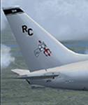
| Category: Flight Simulator X - AI Aircraft | |
| Fsx Air Flamenco Trislander Textures |
|
Images related to this file:
File Description:
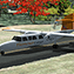
Fsx Air Flamenco Britten-Norman Bn-2A Mk III Trislander Textures.
Air Flamenco is a small fleet based in San Juan, Puerto Rico, which connects the main island with the smaller ones of Vieques and Culebra. They may occasionally fly to the US and British Virgin Islands. There are nine BN-2, three Shorts and a Trislander active to this date.
This texture for Air Flamenco Trislander N920GD completes my previous Air Flamenco fleet available on Flightsim.com and Avsim (air_flamenco_fleet_2021.zip). Requires Michael Pearson's base model mpai_bn2am3_trislander_traffic.zip, available on Avsim.
The model should be compatible with FSX up to P3Dv3. Please refer to modeler's documentation.
I've also added flight plans based on Flightradar24's and other websites. They are not 100% accurate but should provide an idea of the recent traffic.
| Filename: | Fsx_Air_Flamenco_Trislander_Textures.zip |
| License: | Freeware |
| Added: | 17th December 2021, 00:23:30 |
| Downloads: | 125 |
| Author: | Freddy Guerra |
| Size: | 1.07 MB |
| Category: Flight Simulator X - Scenery | |
| Bahamas Airfield Package (BAP) |
|
Images related to this file:
File Description:

Get the "full Bahamas"... The "Bahamas Airfield Package" contains ALL 64 airfields and airports in the Bahamas - a complete country especially (re-) designed for VFR pilots!
All required objects libraries are included in the download. Nassau Intl (MYNN) comes as a "free loan" of Menno C. Robert. Big thank you for that, Menno :-)
Look forward to an improved version of ALL Bahamian airfields with a lot of atmosphere, many details and some landclass enhancements.
Since the original FSX didn't contain all existing airfields in the Bahamas, I've added the missing 5 airports. Two of them comes along with a complete new designed island as well. A comprehensive manual is also provided. Requirements: FSX with Acceleration pack and Ultimate Terrain X - The Tropical Americas & Caribbean (= UTX-TAC)!
| Filename: | Bahamas_Airfield_Package_BAP.zip |
| License: | Freeware |
| Added: | 21st June 2013, 07:25:51 |
| Downloads: | 4,933 |
| Author: | Dirk Cremer |
| Size: | 129.09 MB |
| Category: Flight Simulator X - Aircraft Repaints, Textures and Modifications | |
| Sea Bee Air Grumman Goose (ZK-ENY) |
|
Images related to this file:
File Description:

This folder contains a repaint for the Grumman Goose Redux, available at OZx, in the colors of ZK-ENY(c/n 1145), of of the Gooses that flew with Sea Bee Air from Mechanics Bay, Auckland, New Zealand, connecting Waiheke Island with Auckland between 1976 and 1988, when the company had to close its doors. Originally with the Royal Navy as FP495, it also flew with the NYPD as N1200V, went to Canada as CF-RQI and back to the US before arriving in New Zealand. It was sold to Australia in 1989 as VH-ENY and continued to Thailand as HS-TOM. It is cuurently in Germany, and has been under restauration for years now, Repaint by Jan Kees Blom, based on the paintkit by the OZx team.
| Filename: | Sea_Bee_Air_Grumman_Goose_ZKENY.zip |
| License: | Freeware |
| Added: | 11th July 2018, 17:12:21 |
| Downloads: | 164 |
| Author: | Jan Kees Blom |
| Size: | 22.6 MB |
| Category: Prepar3D V1-4 - Aircraft Repaints, Textures and Modifications | |
| North American P-51D 353rd FG (YJ-L) "Willit Run?" |
|
Images related to this file:
File Description:
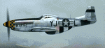
This folder contains a repaint for the A2A WoP3 P-51D Mustang, in the colors of P-51D-10-NA 44-14771 YJ-L "Willit Run?" which flew with the 351st FS, 353rd FG from Raydon in the UK, with Maj Frederick LeFebre as its regular pilot. The P-51 is named “Willit Run?â€, but the nose art on this plane is not talking about this particular aircraft or any P-51 for that matter. It’s an inside joke of WWII vintage.
During WWII, as in every big war, private industry is called upon to produce war goods rather than civilian goods – “guns vs. butterâ€. Henry Ford took on a huge project to contract-build Consolidated B-24 Liberator bombers in a new state-of-the-art manufacturing facility to be built on a farm which Henry Ford owned at Willow Run near Detroit. The facility was to be a prime example of Roosevelt’s “Arsenal of Democracyâ€, conceived and built on an unprecedented scale. Begun in April, 1941, it was the largest enclosed room in the world, with 3.5 million square feet. But Willow Run had a long and troubled construction and start-up time. So long and troubled a start-up, that after two years with little results the public became disillusioned with the project and derisively nicknamed the plant “Willit Run?â€.
Ford persevered however, and Willow Run finally hit its stride, eventually producing at the prodigious rate of 650 B-24 bombers per month by August, 1944. At war’s end, Willow Run had produced about half of the 18,000 B-24's which saw service in the war.
Repaint by Jan Kees Blom, based on the A2A paintkit.
| Filename: | North_American_P51D_353rd_FG_YJL_Willit_Run.zip |
| License: | Freeware |
| Added: | 18th November 2018, 16:21:26 |
| Downloads: | 60 |
| Author: | Jan Kees Blom |
| Size: | 12.3 MB |
| Category: X-Plane - Original Aircraft | |
| Black Cat PBY5/5A |
|
File Description:
X-Plane 6.40
The PBY Catalina is probably the best known flying boat with over 4000 produced by Consolidated aircraft and licensees. The Black Cat squadrons all done in flat black played havoc particularly for the Japanese in the Pacific in WWII. Fitted with radar, with a 15 hour endurance and 2800 mile range they hunted Japanese naval ships and bombed or torpedoed them by the hundreds. This a fairly accurate rendition of the PBY except that the retractable pontoons are missing. Why? Well basically after using all the tricks I know I ran out of parts. There are 6 engine nacelles used in the model, 2 represent the 1200 HP radial engines driving the props, the others are jets with 5 lbs of thrust, 1 is used for the rear fuselage section, 1 is used for the wing pylon, 1 is used for the flare from the fuselage to the vertical stabilizer and the last is used for the forward observation and gunner space. Two are not used. Wing sections are taken up by the main wing and the support spars so there you go. The fuel tanks are used for the side gunner pods since these can be decorated separately. The plane flies very well and is stable. Takeoffs from water are quite easy as long as you don't dip a wing tip (no floats remember). This aircraft model and the paint scheme is copyright by Robert App, January 2003. Feel free to alter the paint scheme and instrument panel as long as you give me credit for the original design. The Black Cat squadron logo used in the paint scheme is courtesy of http://www.daveswarbirds.com/blackcat/logos.htm and is from the VP-71 Black Cat squadron. E mail me with any good panels or paint schemes and I will give full credit if used.
| Filename: | Black_Cat_PBY55A.zip |
| License: | Freeware, limited distribution |
| Added: | 16th January 2003, 02:56:49 |
| Downloads: | 1,386 |
| Author: | Robert L. App |
| Size: | 12.04 MB |
| Category: Flight Simulator 2004 - Scenery | |
| CPR5 - Woodstock - Ontario, Canada |
|
Images related to this file:
File Description:
This is the first of a south Ontario series. Woodstock is a town with a population of around 38,000, located 50 miles west of Lake Ontario. The airfield is 3 miles west of the town, with a single grass runway just over 3,000 feet long and 100 plus feet wide, aligned 05/23 in FS9 (in fact it is now 06/24 due to the magnetic north wandering off during the last 10 years). There have been at different times varying amounts of gravel mixed in with the grass on both runway and taxiway; the majority surface by far is grass and I have left it all as such, as there is no visually convincing way to mix the two without unreal sharp edges. The apron is on the northern side of the runway, and is now modified in shape to maximise the area available for crops. There are 10 "T" hangars and a small clubhouse in a single long building. There is no fuel, runway lighting, or taxiway or apron lights so usage is effectively restricted to daylight hours. To the east of CPR5 and on the edge of the town is a private airstrip with 2,800 feet of asphalt runway; I have added this as a visual reference, along with several large grain silos on the other side of the road. Hidden in plain sight amid the surrounding farmland, the first sighting of CPR5 is actually always of the adjacent and far more visible buildings just to the east of the apron, which are owned by a company that deals with everything to do with boats, up to and including fishing gear. These have been included. As ditches cannot be effectively duplicated in FS9 I have included some fences which do not exist in real life, to give some needed visual clues.
| Filename: | CPR5__Woodstock__Ontario_Canada.zip |
| License: | Freeware, limited distribution |
| Added: | 8th July 2015, 13:36:05 |
| Downloads: | 185 |
| Author: | Roger Wensley |
| Size: | 5.57 MB |
| Category: Flight Simulator 2004 - Scenery | |
| Frozen Canadian & USA Rivers & Lakes Revision |
|
Images related to this file:
File Description:
This "freezes" all lakes and rivers for winter flying and means they can be landed on with skis or wheels; it is meant for low level flying rather than high level jet flights. This edition is complete in itself and now really covers all of Canada and parts of the USA along the border, including large parts of Michigan, Wisconsin, Minnesota, North Dakota, and Montana. It is reversible with an "untick" in the FS scenery library. The revision is the addition of frozen sea in the area of Baffin Island (where I and Sid & Pete have recently posted all of the Baffin Island airfields) as I missed this area last time. Sorry about that. I have spent some time making sure that the sea and the inlets along the coast in the south do not get frozen too, and also some of the lakes that are close to the coast and rarely get cold enough to freeze over. The Great Lakes do not usually totally freeze, but this is an either ON or OFF modification and partial freezing cannot be convincingly simulated, so I went for total ice. Along the north shore I went for the peak of the winter with sea ice all the way to the permanent polar cap; this is not totally realistic as there is usually a partially open lead along the coast, but as with the Great Lakes...... It will work without Ultimate Terrain, but as UT is what gets all the lakes and rivers there and in the right place (except in the far north) it is obviously much improved with UT. The pics show Rockcliffe in the winter with the frozen Ottawa River for real and in FS for comparison; without UT the river would not be in the right place.
| Filename: | Frozen_Canadian__USA_Rivers__Lakes_Revision.zip |
| License: | Freeware, limited distribution |
| Added: | 6th September 2011, 00:42:43 |
| Downloads: | 622 |
| Author: | Roger Wensley |
| Size: | 1.2 MB |
| Category: Flight Simulator 2004 - Scenery | |
| Brevoort CWOB and BAF-3 radar plus Cartwright LAB-6 radar Canada |
|
Images related to this file:
File Description:
Brevoort airstrip and the BAF-3 radar it serves is on Brevoort Island, off one of the southeastern tips of Baffin Island and 140 miles east of Iqaluit. This scenery includes the BAF-3 buildings on the hilltop and those on the airstrip below, plus the roads connecting them and down to the beach landing area on the rocky coast. This scenery is made for the FSGenesis 76m terrain mesh for northern Canada, and there will be a repost of all my northern Canada airfields to suit this; I cannot think now why I never installed this mesh before. The AI reflects the use of civil airlines for resupply and transportation of personnel. Given the terrain the wind should be from the north so that ai lands using the 02 runway. Landing from the north will involve a terrain clash while take off towards the north will not as the climb out clears the hilltop. The video shows the 600 foot cliff at the runway threshold and an Air Tindi plane on the apron. Cartwright CYCA is on the Labrador coast and has been posted by Flight Ontario as part of their Goose Bay and Labrador Regional Airports sceneries. The nearby LAB-6 radar site is included here, connected to CYCA by an extended road. The site uses the same buildings as Brevoort and Saglek (posted recently) and although I have included them here as separate sceneries the contents can be placed in the same folders as Saglek with a saving in duplicated textures. The textures here are more accurate than Saglek so say yes to over-write; a downloader with personal experience of Brevoort noted that in reality they are lighter.
| Filename: | Brevoort_CWOB_and_BAF3_radar_plus_Cartwright_LAB6_.zip |
| License: | Freeware, limited distribution |
| Added: | 20th August 2017, 15:46:36 |
| Downloads: | 175 |
| Author: | Roger Wensley |
| Size: | 4.37 MB |
© 2001-2026 AVSIM Online
All Rights Reserved
Privacy Policy |