
Where Flight Simulation Enthusiasts Gather from Around the World!
AVSIM Library - Search Results

| Category: Prepar3D V1-4 - Scenery | |
| Lamb Holm Airfield and Churchill Barriers |

|
File Description:
P3D v4.5 Scenery - SCO3_Lamb Holm Airfield and the Churchill Barriers, Orkney, Scotland.
This scenery needs OrbxTENorth product to be installed and offers an enhancement to the airfield in that product. The Churchill Barriers are missing from the Orbx product. Also included is the Italian Chapel, a popular tourist attraction on the island. This building was built by Italian prisoners of war during World War ll. They also built the barriers. Road traffic has been re-aligned to roads and barriers and also has reduced density built in. The main runway is able to accomodate AI traffic and a flightplan for flights from Lamb Holm to other local airfields is included. This is the first of a series of airfield packages to add to and enhance the airfields included in TENorth and TECentral.
| Filename: | Lamb_Holm_Airfield_and_Churchill_Barriers.zip |
| License: | Freeware |
| Added: | 30th March 2020, 01:44:11 |
| Downloads: | 140 |
| Author: | Scotflight Freeware |
| Size: | 31.35 MB |
| Category: Flight Simulator X - AFCAD Files | |
| RPLL - Ninoy Aquino International Airport - Manila, Philippines |
|
File Description:
This is an updated AFCAD for Pacific Island Sim's RPLL Ninoy Aquino International airport designed specifically for AI traffic.
This AFCAD was tested using all the newest aircraft and flightplans currently available during the Spring 2015 season.
Changes include:
-Transferred ANA, Delta, Emirates, Cathay Pacific, KLM, and Singapore Airlines to Terminal 3.
-Added overflow gates inside and outside Lufthansa hangars.
-Resized many gates.
-Changed many airline codes through the airport.
-(Optional) Closed runway 13/31 because it attracts jumbos to land there instead of 06/24, the runway jumbos use in real life (There is a bgl file with open runways).
ZipDive to see photos. You will need the payware Ninoy Aquino International Airport by Pacsim for this AFCAD.
| Filename: | RPLL__Ninoy_Aquino_International_Airport__Manila_P.zip |
| License: | Freeware |
| Added: | 26th March 2015, 02:03:09 |
| Downloads: | 1,276 |
| Author: | Ryan Gonz / Pacsim |
| Size: | 694.1 KB |
| Category: Flight Simulator 2004 - Original Aircraft | |
| 3 Herons - part 3: De Havilland Heron 2D Heron Airlines |
|
Images related to this file:
File Description:
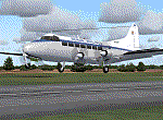
The De Havilland Heron must be the smallest four engine airliner in the world! And it can take off and land almost anywhere. This, the third in my Three Herons series, represents the Mark 2D which was a re-engined version of the 2B with Lycoming engines. This is VH-NJP, one of two such aircraft operated by the aptly named Heron Airlines from 1991 to 2000 out of their base at Bankstown Airport, Sydney, Australia to destinations such as Deal Island, Birdsville and Cape York for all-in adventure holidays. This package includes a high detail panel featuring many new gauges. As these gauges are common to all three in this series, these have been placed in a separate download herongg.zip.
See also 3h-rnupd.zip
[File re-uploaded at request of AVSIM]
| Filename: | 3_Herons__part_3_De_Havilland_Heron_2D_Heron_Airli.zip |
| License: | Freeware |
| Added: | 15th June 2010, 01:05:21 |
| Downloads: | 6,124 |
| Author: | John Hinson, Billy Rutherford & Dee Waldron |
| Size: | 858.83 KB |
| Category: Flight Simulator 2004 - Scenery | |
| US North Cascades Mountains and Northwest Washington Coast |
|
File Description:
The files in this package completely replace the FS default landscape of the North Cascades Mountains and coastal areas of northwestern Washington State. Between Bellingham and Arlington (N-S), Orcas Island and Lake Chelan (W-E) you can now enjoy your VFR flights with accurate locations of coastlines, lakes, rivers, streams, roads, railroads, and power lines, as well as land use type (landclass) and terrain (add-on mesh). Also added are the larger glaciers of the majestic North Cascades volcanoes and peaks as well as several forestry roads and clearcuts outside the National Park and Wilderness areas. Made mostly with Christian Fumey's "Ground2K4" and Jim Keir's "Slartibartfast". Fully compatible with the recent freeware LOD10 add-on meshes of the western US. Mesh and landclass files will work in FS2002 but not the special scenery enhancements.
| Filename: | US_North_Cascades_Mountains_and_Northwest_Washingt.zip |
| License: | Freeware, limited distribution |
| Added: | 18th May 2004, 23:12:57 |
| Downloads: | 14,319 |
| Author: | Holger Sandmann |
| Size: | 12.72 MB |
| Category: Flight Simulator X - Scenery | |
| Kavala - Greece |
|
Images related to this file:
File Description:
Kavala DN
AS REAL AS IT GETS.
This is a highly detailed photorealistic scenery of the beautiful Kavala area
and the Island of Thasos WITH NIGHT TEXTURES.
The scenery contains many objects like cars, boats and buldings in many cities
like Kavala, Keramoti, Thasos and around the airport.
Default FSX airport Megas Alexandros (LGKV) and Amigdhaleon (LGKM) were
corrected and repositioned to their exact location, runway 05L was added,
many buildings and trees, aircraft hangers, airforce static aircraft and army vehicles.
Also I added 2 small aircraft traffic files and a small file for helicopter traffic.
Check the Oil Rig in Kavala Bay and try to land on the helipad.
The scenery also includes the customary autogen buildings, vegetation and
road traffic near the cities to enhance and animate the landscape.
| Filename: | Kavala__Greece.zip |
| License: | Freeware |
| Added: | 24th November 2016, 17:35:13 |
| Downloads: | 1,466 |
| Author: | Angelo Tassoglou |
| Size: | 200.36 MB |
| Category: Flight Simulator 2004 - Scenery | |
| Igloolik CYGT in Nunavut Canada |
|
Images related to this file:
File Description:
Igloolik is a village of 1,600 or so inhabitants at N 69 22 W 81 49 on Igloolik Island, off the northeast corner of the Melville Peninsula. It's name means approximately "Place With A House". The village does not feature in FS9 but is included in this scenery with approximately the right shape, as were the series of northern sceneries before this one. The airfield runway is 4,095 feet of gravel 100 feet wide and is at 173 feet above sea level. There is a gradient to it, but unfortunately this cannot be replicated in FS. I added the roads, a new airfield background, plus of course there is the scenery file and the AFCAD and AI, which has two planes visiting, a First Air HS748 and a Canadian North Dash 8-100.
| Filename: | Igloolik_CYGT_in_Nunavut_Canada.zip |
| License: | Freeware, limited distribution |
| Added: | 23rd December 2010, 02:28:26 |
| Downloads: | 522 |
| Author: | Roger Wensley |
| Size: | 2.7 MB |
| Category: Flight Simulator X - Scenery | |
| Kuujjuaq CYVP - v2 |
|
Images related to this file:
File Description:
Kuujjuaq is in northern Quebec, Canada. At the southern end of Ungava Bay, and 30 miles up the Koksoak River. it was previously called Fort Chimo. Kuujjuaq is considered the capital of Nunavik, a well known northern caribou hunters and a large base of Air Inuit relay.
The scenery includes:
- The airport and its major buildings and objects,
- Weather radar on a hill northeast of the airport,
- The Zelada Desgagnes stranded facing the village and Sedna Desgagnes traveling between Kuujjuaq and the Ungava Bay,
- Large boats moving on the Koksoak River, near the island Koksoak,
- Hydrobase Stewart Lake, 2.3 miles north of the airport,
- A hunting camp (with caribou!), A geological camp and fishing camp (with cabins, tents and canoes).
| Filename: | Kuujjuaq_CYVP__v2.zip |
| License: | Freeware, limited distribution |
| Added: | 12th March 2014, 09:23:10 |
| Downloads: | 2,108 |
| Author: | Jean-Pierre Fillion, Pierre Gallant |
| Size: | 7.04 MB |
| Category: Flight Simulator 2004 - Scenery | |
| Coral Harbour CYZS in Nunavut, Canada |
|
Images related to this file:
File Description:
Coral Harbour is on Southampton Island, which partly blocks the northern end of Hudson Bay and is around the size of Switzerland. The village has a population of just under 800 people and is some 200 miles from Cape Dorset, Ivujivik, and Repulse Bay, and 230 miles from Chesterfield Inlet to the southwest. Cape Dorset and Ivujivik have already been posted and Chesterfield Inlet will be posted later this month. The airfield is inland from the village and the 5,000 feet of gravel runway is aligned 155T/335T where T stands for "true" as opposed to magnetic in the Northern Domestic Airspace. JETA-1 fuel is officially available, and in practice so is 100LL, though the latter will be in drums. The visiting AI airlines are First Air and Calm Air.
| Filename: | Coral_Harbour_CYZS_in_Nunavut_Canada.zip |
| License: | Freeware, limited distribution |
| Added: | 29th November 2011, 00:43:08 |
| Downloads: | 369 |
| Author: | Roger Wensley |
| Size: | 3.83 MB |
| Category: Flight Simulator 2004 - Flight Plans | |
| Sounds Air, New Zealand - 2 Flights - Sep 2006 |
|
File Description:
Two little flights - set in the modern era, which is a departure for me - that are replicas of the real-world services offered by New Zealand's "Sounds Air" company. As well as providing scenic flights and charters they also operate timetabled services between Wellington and locations across Cook Straight in the South Island, such as Picton, Nelson and Kaikoura, the latter two being featured here. Their web-site is at ->> http://www.soundsair.com/ <<- and is worth a visit as there is full information relating to the timetables and also some great photographs. The aircraft used in this re-enactment - KLC - is also featured. The FS2004 model - the GA-8 Airvan by Mike Stone - is available at his site:- www.pmstone.com.
The Sounds Air livery - by Dan Hayward - is available here at Avsim.com and is named ga8klc.zip.
| Filename: | Sounds_Air_New_Zealand__2_Flights__Sep_2006.zip |
| License: | Freeware |
| Added: | 23rd September 2006, 06:17:38 |
| Downloads: | 404 |
| Author: | Bruce Kennewell |
| Size: | 241.14 KB |
| Category: Flight Simulator X - Scenery | |
| CYGR and Ile de la Madeleine |
|
Images related to this file:
File Description:
The Magdalen Islands (in French, Iles de la Madeleine) form a small archipelago in the Gulf of Saint Lawrence. Though closer to Prince Edward Island and Nova Scotia, the islands are part of the Canadian province of Quebec.
There are eight major islands: Havre-Aubert, Grande Entree, Cap aux Meules, Grosse Ile, Havre aux Maisons, Pointe-Aux-Loups, Ile d'Entree and Brion. All except the latter are inhabited. There are several other tiny islands which are also considered part of the archipelago: Rocher aux Oiseaux, Ile aux Loups-marins, Ile Paquet and Rocher du Corps Mort.
This scenery include CYGR airport, hangar and terminal, static plane, Ile d'Entree runways, AI ships moving in this area, local harbours and fishing boats, new landclass definition and many authors's and default FSX objects populating islands.
| Filename: | CYGR_and_Ile_de_la_Madeleine.zip |
| License: | Freeware, limited distribution |
| Added: | 23rd December 2011, 18:14:40 |
| Downloads: | 4,112 |
| Author: | Pierre Gallant & Jean-Pierre Fillion |
| Size: | 11.96 MB |
© 2001-2026 AVSIM Online
All Rights Reserved
Privacy Policy |