
Where Flight Simulation Enthusiasts Gather from Around the World!
AVSIM Library - Search Results

| Category: Flight Simulator 2004 - Scenery | |
| PAAK - Atka Airport - Aleutian Islands, Alaska, USA |

|
Images related to this file:
File Description:
Atka is near the western end of the Aleutian chain of islands in Alaska, around 100 miles east of Adak and 330 miles west of Dutch Harbor. The small town (population around 60 now, down from 90 only 5 years ago; so quickly?) is reliant on fishing. The airport is a mile or so north of the town on the east coast of the island, with a single runway of 4,500 feet of asphalt, and there are scheduled flights by Grant Aviation from Dutch Harbor (included in the AI posted with Adak).
| Filename: | PAAK__Atka_Airport__Aleutian_Islands_Alaska_USA.zip |
| License: | Freeware, limited distribution |
| Added: | 17th January 2015, 19:08:38 |
| Downloads: | 268 |
| Author: | Roger Wensley |
| Size: | 2.55 MB |
| Category: Flight Simulator X - Scenery | |
| FSX Scenery Only Iceland Airports Update 2023 |
|
Images related to this file:
File Description:
Published first in 2015 with over 11,000 downloads, I think it time to update since so many changes
have occurred around Keflavik and Reykjavik. This scenery offers extensive revisions to Keflavik airport
with a new terminal with transparent windows and interior, new passenger and cargo aprons, control tower,
and more. A totally new scenery of Vestmannaeyjar island and airport with harbor, volcanoes, ferries, and
two working lighthouses is included. Fagradasfjall volcano is now active and spewing fire and lava north
of Keflavik.Some free downloadable libraries required. This scenery REPLACES the old version.
by Dan French
| Filename: | FSX_Scenery_Only_Iceland_Airports_Update_2023.zip |
| License: | Freeware, limited distribution |
| Added: | 12th October 2023, 15:26:42 |
| Downloads: | 529 |
| Author: | Dan French |
| Size: | 12.49 MB |
| Category: Flight Simulator X - Scenery | |
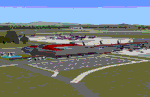
| Jersey X-HD |
|
Images related to this file:
File Description:

Jersey is a small airport located on the island of Jersey in the English Channel. Originally opened in March 1937 the airport has been through several changes and improvements. This scenery is an accurate representation of the airport today.
Features include: -High definition ground image. -High definition ground detailing. -Accurate ground markings. -Vehicles hidden inside closed hangars. -Beautiful night lighting. -Custom AFCAD for improved AI. -3D Approach lights. -Many static objects. -Reflective windows on tower. -Very frame rate friendly. -Hold short guards and PAPIs. -Illuminated Taxiway center light effect.
| Filename: | Jersey_XHD.zip |
| License: | Freeware, limited distribution |
| Added: | 20th January 2017, 17:42:42 |
| Downloads: | 3,364 |
| Author: | Mark Piccolo - Soarfly Concepts |
| Size: | 23.66 MB |
| Category: Flight Simulator 2004 - Scenery | |
| Edinburgh Island, FOX-2, Horton River, Igloolik, & Kimmirut, adapted for the FSGenesis 76m North Canada Terrain Mesh |
|
Images related to this file:
File Description:
These are replacement bgl's to convert five northern Canada fields for use with the FSGenesis 76m terrain mesh for northern Canada. The five are Edinburgh Island CWEI, the FOX-2 DEW line station, Horton River CWHR, Igloolik CYGT, and Kimmirut CYLC. These are not stand-alone, and the presumption is that you have already downloaded and installed the previously posted sceneries. This installation consists solely of replacing the existing scenery bgl's with the new. There will be further posts of northern airfields in groups of five, alphabetically, and observations regarding the amendments and any further corrections that are required would be welcomed.
| Filename: | Edinburgh_Island_FOX2_Horton_River_Igloolik__Kimmi.zip |
| License: | Freeware, limited distribution |
| Added: | 10th September 2017, 19:29:57 |
| Downloads: | 86 |
| Author: | Roger Wensley |
| Size: | 3.55 MB |
| Category: Flight Simulator 2004 - Aircraft Repaints, Textures and Modifications | |
| jetBlue Airways Airbus A320-232 Pack |
|
Images related to this file:
File Description:

jetBlue "Tartan Tailfin" (N565JB) - jetBlue "Vets in Blue" (N775JB) - jetBlue "Blue Bravest" (N615JB)
JetBlue Airways Corporation, often stylized as "jetBlue", is an American low-cost airline. The company is headquartered in the Long Island City neighborhood of the New York City borough of Queens. Its main base is John F. Kennedy International Airport, also in Queens.
The airline mainly serves destinations in the United States, along with flights to the Caribbean, The Bahamas, Bermuda, Barbados, Colombia, Costa Rica, Dominican Republic, Jamaica, Mexico and Puerto Rico. As of May 23, 2013 JetBlue serves 78 destinations in 22 states, and twelve countries in the Caribbean, South America and Latin America. jetBlue maintains a corporate office in Cottonwood Heights, Utah. JetBlue is a non-union airline.
Jetblue liveries are painted on Project Airbus A320-232 model (not included). The textures are saved in 32bit format for quality graphics. Textures are also characterized by HD (High Definition). Its features are idle-reverser animation, animated pack vents and pressurisation outflow valve, detailed textures, accurate paint, dynamic shine & effects, dynamic flexing wings that respond to turbulence, fully independent suspension, trim animation, gear steering, accurate flight dynamics, spoiler animation, reflective cockpit windows, improved wingflex code with input from several new parameters including ground spoilers, fuel load, and angle of attack, transparent navigation light lenses and many more.
Visit our Facebook page "Sky Level Textures" for news, updates and previews on our future repaint projects. Thanks for downloading & Happy flying. HD GAMING EXPERIENCE inside. https://www.facebook.com/SkyLevelTextures
| Filename: | jetBlue_Airways_Airbus_A320232_Pack.zip |
| License: | Freeware |
| Added: | 26th November 2014, 22:44:49 |
| Downloads: | 2,222 |
| Author: | Giacomo Tomasini | Sky Level Textures | Project Airbus |
| Size: | 36.66 MB |
| Category: Flight Simulator X - Aircraft Repaints, Textures and Modifications | |
| North American P-51D Mustang "Boo-Man Choo" (N51MV) |
|
Images related to this file:
File Description:
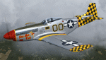
A repaint only for the payware Warbirdsim product 'Mustang Tales'. This repaint depicts the restored P-51D-25-NT 45-11391, "Boo-Man Choo", registered N51MV. This aircraft has a long civilian history, having been first registered with the FAA in 1963. In the 1990's, this aircraft became a popular sight when owned by Wally Sanders and painted as "Nervous Energy IV", and could sometimes be seen flown by the late, great Jeff Ethell. In the years since, the aircraft has passed through several owners, though the same over-all paint scheme has remained. In 2005, the aircraft's name was changed to "Luscious Lisa". In 2008, not long after having switched hands, the aircraft was damaged in a hard landing. For the next four years the aircraft was repaired and rebuilt, flying again in May 2012. The aircraft's most recent owner is Col. Ray Hofman, who now bases the aircraft in Midland, TX. The aircraft is now named "Boo-Man Choo", which is derived from the nickname of Col. Hofman's son, "Boo-Man". The nose art was inspired by the nurse character from the animated cartoon Animaniacs. This repaint features new bump maps, wheel well, gun bay, and cockpit textures.
| Filename: | North_American_P51D_Mustang_BooMan_Choo_N51MV.zip |
| License: | Freeware |
| Added: | 17th April 2013, 06:21:24 |
| Downloads: | 190 |
| Author: | John Terrell |
| Size: | 27.52 MB |
| Category: Flight Simulator 2004 - Scenery | |
| PAAQ - Palmer Muni - Anchorage, Alaska - USA |
|
Images related to this file:
File Description:
Palmer PAAQ is in Alaska, some 40 miles northeast of Anchorage on the north side of Knik Arm and beside the west bank of the Matanuska River. It is for both GA and commercial aircraft. There are two apron areas, north and south, separated by the east-west runway. The north apron is for the Forestry Service planes and for resident GA tie-down places and hangars, along with maintenance facilities; the southern end of the north apron is for itinerant aircraft. The south apron is almost entirely for commercial companies and again maintenance. The main runway is just under 6,000 feet long, aligned L16-R34 and asphalted and lit, as is the parallel taxiway A. There is also a shorter and parallel runway that is grass and which receives no winter maintenance. The second main runway is 3,600 feet long and aligned 09-27, asphalt and lit and with a parallel taxiway B, also lit. The airport is undergoing a process of upgrading, which explains the varied colours (and age) of resurfaced taxiways. There are adjustment bgl's for two other neighbourhood airstrips, Toad Lake 24AK and Wolf Track 9AK8, which I just discovered buried in nearby holes in the ground; I also revised their runway surfaces.
| Filename: | PAAQ__Palmer_Muni__Anchorage_Alaska__USA.zip |
| License: | Freeware, limited distribution |
| Added: | 4th November 2014, 00:01:43 |
| Downloads: | 446 |
| Author: | Roger Wensley |
| Size: | 22.35 MB |
| Category: Flight Simulator 2004 - Scenery | |
| Peawanuck CYPO / Winisk CYWN - Northern Ontario, Canada |
|
Images related to this file:
File Description:
Peawanuck is on the bank of the Winisk River, 23 miles upstream from where the river empties into the Hudson Bay just west of James Bay. It has a population of around 240, and was established in 1986 when the original settlement (Winisk) at the mouth of the river was destroyed by a flood. The airport is on a bluff in a corner of the river at 171 feet ASL, with a gravel runway just over 3,500 feet long and aligned 11-29. There is only basic runway lighting, with no ILS, VASI, or PAPI; there is also no apron lighting, or fuel. Service is provided by Air Creebec with connector flights to Moosonee and Timmins, and on to Montreal. A search of their timetable did not provide any information regarding timings but I made the AI flight from Timmins a daily one; it is probably only once or twice a week. There is also a daily private Cessna from Moosonee. Winisk, at the mouth of the river, has another gravel runway which is over 6,000 feet long. There is also a large hangar and to the north the remaining buildings and fuel tanks etc of a Radar Control site which was closed in 1965 after only 7 years of use.
| Filename: | Peawanuck_CYPO__Winisk_CYWN__Northern_Ontario_Cana.zip |
| License: | Freeware, limited distribution |
| Added: | 29th December 2012, 09:14:03 |
| Downloads: | 280 |
| Author: | Roger Wensley |
| Size: | 2.61 MB |
| Category: Flight Simulator 2004 - Scenery | |
| Qikiqtarjuaq CYVM (Broughton) and DEW FOX-5 in Nunavut, Canada |
|
Images related to this file:
File Description:
Qikiqtarjuaq is an airfield on the northeast coast of Baffin Island, just over 100 miles north of Pangnirtung. The airfield is the closest Canadian airfield to Greenland and is used for ferry flights from Canada to Europe for small planes, though there is normally only JetA1 fuel available. The airfield is at only 18 feet ASL next to the sea with the village to the north; it was previously (before 1998) called Broughton Island. The runway is 3,800' of 100' wide gravel and is lighted; as it is in the Northern Domestic Airspace the runway is signed as 033T-213T, using "true" bearings instead of magnetic. There is a terminal and a small maintenance building on the apron and these have been modeled specifically for this scenery. There are AI parking spots; the AI visiting aircraft are a Canadian North Dash 8 and a First Air 42-300. Qikiqtarjuaq village is just north of the airfield and has a population of around 520; it is approximately the right size and shape but no buildings were specifically modeled for the village. There is also a North Warning System site called Fox-5 to the northeast, and this too is included. You will need Ultimate Terrain Alaska Canada.
| Filename: | Qikiqtarjuaq_CYVM_Broughton_and_DEW_FOX5_in_Nunavu.zip |
| License: | Freeware, limited distribution |
| Added: | 14th June 2011, 02:04:26 |
| Downloads: | 555 |
| Author: | Roger Wensley |
| Size: | 1.85 MB |
| Category: Flight Simulator 2004 - Scenery | |
| PAHT - Amchitka - Aleutians, Alaska - USA |
|
Images related to this file:
File Description:
Amchitka is near the western end of the Aleutian chain of islands in Alaska, around 180 miles west of Adak, and was not included in FS9. There is no small town on Amchitka Island, which is why it was used for atom bomb testing after being closed down as an Air Force base. There are three runways from the 1940's, the largest of which is aligned 07-25 and just over 10,000 feet of overgrown asphalt 300 feet wide. The second runway is aligned 15-33 and 6,000 feet (also 300 feet wide) and the third is 05-23 and 5,000 feet. The whole eastern end of the island is crowded with old munitions storage areas and other military paraphernalia, including old quonset huts; some of those are included here. There are also some old buildings still standing but on their way to becoming piles of old wood or rust, and some of these are included. There is almost no visual information available about Amchitka; even Google Earth has snow obscuring what buildings still exist and where they are, so much of this is at best only approximate apart from the two large hangars. There are no markings, lights, signage, or a control tower.
| Filename: | PAHT__Amchitka__Aleutians_Alaska__USA.zip |
| License: | Freeware, limited distribution |
| Added: | 6th February 2015, 00:06:26 |
| Downloads: | 268 |
| Author: | Roger Wensley |
| Size: | 2.6 MB |
© 2001-2026 AVSIM Online
All Rights Reserved
Privacy Policy |