
Where Flight Simulation Enthusiasts Gather from Around the World!
AVSIM Library - Search Results

| Category: Flight Simulator 2004 - Scenery | |
| Greece SRTM Mesh Part 1 |

|
File Description:
This terrain mesh scenery covers Greece, including all Aegean sea islands, plus most parts of Albania and Macedonia up to 41°50'N. Some parts of Bulgaria and Turkey are also included in northern and eastern boundaries of the mesh. The greek island of Crete isn't part of this mesh because SRTM data isn't yet released for the whole island.
Based on SRTM Data (3 arcsec, 90m), generated with Matthew Styles's program "SRTM To BGL v1.04", sampled to LOD9 resolution (76m). While only tested with Fs2004, this mesh should also run with FS2002.
This part contains northern parts of the mesh: Greece-N.bgl, Greece-NE1.bgl and Greece-NE2.bgl. See Greece_Mesh_Part1-1.jpg for exact bgl coverage.
| Filename: | Greece_SRTM_Mesh_Part_1.zip |
| License: | Freeware |
| Added: | 10th November 2003, 02:08:20 |
| Downloads: | 10,984 |
| Author: | Yohann Baptiste |
| Size: | 17.75 MB |
| Category: Flight Simulator X - Scenery | |
| VVCS - Con Dao Airport, Con Son Island, Vung Tau Province, Vietnam |
|
Images related to this file:
File Description:
Côn Äảo Airport or Cá» á»ng Airport (IATA: VCS, ICAO: VVCS) (Vietnamese: Sân bay Cá» á»ng) is located on Côn SÆ¡n Island, the largest island of Côn Äảo archipelago off the coast of Bà Rịa–VÅ©ng Tà u Province, Vietnam.
There is Vietnam Airlines operated by VASCO fly from and to here from Can Tho Airport and Tan Son Nhat International Airport.
There are also 3 battlecruisers, 3 destroyers, 1 aircraft carrier and an oil tanker. They depart from Con Dao Airport at 7 A.M with FSX system time.
You should install FTX ORBX global (And Vector if possible)
| Filename: | VVCS__Con_Dao_Airport_Con_Son_Island_Vung_Tau_Prov.zip |
| License: | Freeware |
| Added: | 1st July 2017, 18:26:23 |
| Downloads: | 1,037 |
| Author: | Minh Bui |
| Size: | 30.55 MB |
| Category: Flight Simulator 2004 - Scenery | |
| Greece SRTM Mesh Part 2 |
|
File Description:
This terrain mesh scenery covers Greece, including all Aegean sea islands, plus most parts of Albania and Macedonia up to 41°50'N. Some parts of Bulgaria and Turkey are also included in northern and eastern boundaries of the mesh. The greek island of Crete isn't part of this mesh because SRTM data isn't yet released for the whole island.
Based on SRTM Data (3 arcsec, 90m), generated with Matthew Styles's program "SRTM To BGL v1.04", sampled to LOD9 resolution (76m). While only tested with Fs2004, this mesh should also run with FS2002.
This part contains all bgl files except Greece-N.bgl, Greece-NE1.bgl and Greece-NE2.bgl. See Greece_Mesh_Part2-1.jpg for details.
| Filename: | Greece_SRTM_Mesh_Part_2.zip |
| License: | Freeware |
| Added: | 10th November 2003, 02:09:45 |
| Downloads: | 10,926 |
| Author: | Yohann Baptiste |
| Size: | 18.54 MB |
| Category: Flight Simulator X - Scenery | |
| TGPY |
|
File Description:
Maurice Bishop International Airport (IATA: GND, ICAO: TGPY), formerly known as Point Salines International Airport, is located in the parish of St. George's. The town of St. George's is about 5 miles (8.0 km) north of the airport and is the capital of the island nation of Grenada. The airport is located on Point Salines, the most southwestern point of the island. It is the most important airport in terms of infrastructure in the northern part of the country and the first in terms of cargo movements.
This file has the right coordenates, with the apron and characteristics of the airport. The runways were resized the gates placed on correct location and number.
| Filename: | TGPY.zip |
| License: | Freeware |
| Added: | 30th April 2011, 00:18:46 |
| Downloads: | 1,951 |
| Author: | Anwar Gonzalez |
| Size: | 7.85 KB |
| Category: Flight Simulator X - Missions | |
| New! HelicopterLighthouseMissionsVol96.zip |
|
File Description:
Six lighthouse tours: Cape Croker, Cove Island, Main Duck Island, San Vito Lo Capo, Southeast Shoal, and Windmill Point.These missions were programmed in Windows 10 (64bit)for FSX Acceleration and will also work in FSX Steam, P3DV3,V4,V5,and V6. However, several of these tours have specific requirements of Orbx scenery which is detailed in the .txt instructions.Photos of all the lites are included in each mission set. Once again, be sure to read the instructions in the .txt files. These missions have been thoroughly tested and should work as described. Due to large topographic differences in P3DV5 and V6, there will be peculiarities, but the missions should still work.
| Filename: | HelicopterLighthouseMissionsVol96zip.zip |
| License: | Freeware |
| Added: | 9th June 2026, 01:03:47 |
| Downloads: | 8 |
| Author: | Helomissionman |
| Size: | 31.79 MB |
| Category: Flight Simulator X - Scenery | |
| Archipelago of St-pierre & Miquelon (non-flat airport) |
|
File Description:
"The archipelago of St Pierre (LFVP) and Miquelon (LFVM)".
Theses islands are situated in the south of New Foundland island, beetwin Canada and United States.
All the archipelago is made up of a new local mesh, landclass, photorealists textures in 2m/pixel in St-Pierre island (4 seasons and the night) with specific autogen, the harbour, various buildings, churches, and reference marks
visual.
The airport of St-Pierre (LFVP) is created with a non-flat runway, as it
is in reality, whith a true lenght profil.
A basic mission named "De Miquelon à St Pierre" is placed at "beginner"
level for discover easely the archipelago.
This scenery is only for FsX and is not compatible with Fs 2004 (Fs9)."
| Filename: | Archipelago_of_Stpierre__Miquelon_nonflat_airport.zip |
| License: | Freeware, limited distribution |
| Added: | 4th July 2008, 16:11:23 |
| Downloads: | 3,936 |
| Author: | Marc-henri Guitteny |
| Size: | 17.41 MB |
| Category: Flight Simulator X - Scenery | |
| South Florida and The Bahamas Water Class |
|
Images related to this file:
File Description:
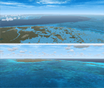
The coverage area begins in the western end of the Florida Keys at The Dry Tortugas, heads north to Tampa, over to Grand Bahama, south to the Cay Sal Bank and eastward to Great Inagua covering all of the Florida Keys and the entire Bahamas Island chain. The scenery also corrects island position errors overlooked by UTX-USA and UTX-TAC in the Dry Tortugas, on the Cay Sal Bank, adding the missing Cays there and also on the Bahama Bank. Lighthouse placement error corrections are also included.
For those pilots with REX Essentials + Overdrive (REX3) a section of the manual is devoted to creating a custom selection of REX3 textures. by Wally-Bob
| Filename: | South_Florida_and_The_Bahamas_Water_Class.zip |
| License: | Freeware, limited distribution |
| Added: | 21st August 2014, 18:50:02 |
| Downloads: | 2,577 |
| Author: | Walter Roberts |
| Size: | 9.25 MB |
| Category: Flight Simulator X - Scenery | |
| Alderney Airport (EGJA) |
|
File Description:
Alderney Airport (EGJA) is located on the island of Alderney in the Channel Islands. I have travelled in and out of the island on many occasions and, despite the lack general lack of information on the internet about the airport, this is a pretty accurate representation. Features include accurate control tower, accurate terminal building, grass parking area, static aircraft, ground vehicles, car park, fire-station, surrounding trees, perimeter fencing and more. Many night textures and custom AFCAD file included. The airport is at N49 42 44 and W002 12 88. This scenery is for FSX but should also work under FS2004. It may even work in earlier versions of FS but this is untested.
| Filename: | Alderney_Airport_EGJA.zip |
| License: | Freeware, limited distribution |
| Added: | 29th October 2006, 03:17:06 |
| Downloads: | 8,384 |
| Author: | Tim Clayton |
| Size: | 2.29 MB |
| Category: Flight Simulator 2004 - Panels | |
| Generic Jet Panel |
|
File Description:
This is a generic panel for any Boeing or Airbus (or CRJ, ERJ, you get the point).
It's my first panel, so it may be kinda bad, but enjoy it anyway! :D :D
All gauges are default FS2004, so as long as you got that, you're in good.
| Filename: | Generic_Jet_Panel.zip |
| License: | Freeware, limited distribution |
| Added: | 17th February 2004, 04:39:26 |
| Downloads: | 1,561 |
| Author: | Seth Ainsley |
| Size: | 120.39 KB |
| Category: Flight Simulator 2004 - Scenery | |
| CYQX Gander 1950 |
|
File Description:
CYQX Gander was one of the most important airports in the world before the advent of long range passenger jet aircraft, and this scenery represents it as it is shown in a Trans Canada Airlines chart of 1950. All the major structures for this scenery have been custom built.
| Filename: | CYQX_Gander_1950.zip |
| License: | Freeware, limited distribution |
| Added: | 31st October 2025, 01:29:20 |
| Downloads: | 62 |
| Author: | Ken Lawson |
| Size: | 21.32 MB |
© 2001-2026 AVSIM Online
All Rights Reserved
Privacy Policy |