
Where Flight Simulation Enthusiasts Gather from Around the World!
AVSIM Library - Search Results

| Category: Flight Simulator 2004 - Aircraft Repaints, Textures and Modifications | |
| Cessna 206 on floats Rust flying Service |

|
Images related to this file:
File Description:

This is an updated version of my Rust's Flying Service Stationair 6 II repainted Cessna 206 texture files. The colors are now darker to reflect the original company colors, the plane is highly weathered and includes my latest floats these one adding residue from standing water. I hope you enjoy this repaint to fly in the Lake Hood Alaska area. You must own a registered copy of Carenado's Cessna 206 in order to use these files.at www.carenado.com
| Filename: | Cessna_206_on_floats_Rust_flying_Service.zip |
| License: | Freeware |
| Added: | 21st March 2010, 21:38:59 |
| Downloads: | 350 |
| Author: | Paul Grenier / Carenado |
| Size: | 1.8 MB |
| Category: Flight Simulator 2004 - Scenery | |
| Hatay Airport V2 LTDA |
|
File Description:
Highly detailed scenery of Hatay New Airport V2 (LTDA) in The Turkey.
Antakya or Hatay, as its official name is today, was founded in 300 BC as Antioch-ad-Orontes by Seleucos Nicator, one of Alexander's generals. Antakya grew quickly to become a city of half a million people and, under the Romans, became one of the main centers of the Christian faith. The city survived a massive earthquake in the 5th century killing 250,000 people. It was later fought over by Persians, Byzantines, Arabs, Armenians, Seljuks, Crusaders and Mamluks. The latter literally wiped out the city and it never regained its former glory. Antakya was part of the French protectorate of Syria until 1939, became independent as the Republic of Hatay for a short period and then joined the Republic of Turkey on 23 July 1939.
| Filename: | Hatay_Airport_V2_LTDA.zip |
| License: | Freeware |
| Added: | 8th March 2008, 22:36:31 |
| Downloads: | 2,061 |
| Author: | Vedat Sencan |
| Size: | 2.07 MB |
| Category: Prepar3D V1-4 - Scenery | |
| Ostia Lido Roma Italy N41.43.21 E12.16.27 |
|
File Description:
Ostia Lido Roma Italy N41.43.21 E12.16.27 The city overlooking the Tyrrhenian Sea is Rome's beach, connected by a fast metro line to Rome and a fast bus service to Fiumicino Airport. The city also includes Ostia Antica, which retains archaeological remains of remarkable value, founded in the 4th century BC. as a military camp and developed during the Roman imperial era as a shopping mall, closely linked to the supply of grain in the capital. Also in the medieval village is the Giulio Castle N41.45.33 E12.18.04 of the Renaissance fortress of the fifteenth century. In the scenario you will find the summer residence of the President of the Republic of Castel Porziano N41.44.37 E12.24.01. Important VFR point for approaching airport International Roma Fiumicino.
Within the downloaded package you will find readme files for scenery installation. Good fly VFR. Pasquale Marrulli.
| Filename: | Ostia_Lido_Roma_Italy_N414321_E121627.zip |
| License: | Freeware |
| Added: | 16th November 2017, 16:39:22 |
| Downloads: | 601 |
| Author: | Pasquale Marrulli |
| Size: | 8.24 KB |
| Category: Flight Simulator X - Utilities | |
| Landing Parameters for FSX and P3D |
|
Images related to this file:
File Description:
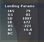
Landing_Params is a Lua script for FSX/P3D that displays landing parameters in a small text window that pops
up after the aircraft has landed and has reached taxi speed. The script should be activated with a key or button (like the gear
down key/button) during the approach to landing. Parameters displayed in the window after touchdown are
Indicated Airspeed (IAS, Kts), Ground Speed (GS, Kts), Landing Distance (LD, ft), Landing Roll (LR, ft), Vertical
Speed (VS, ft/min), Attitude Indicator pitch at touchdown (AI), and Bounce Count (BC). Data collection begins
when the a/c passes through a radar altimeter determined threshold altitude window between 45 and 55 ft
(i.e., the nominal 50ft threshold height). In addition, more detailed landing parameter information may be
logged. A registered copy of FSUIPC is required to execute the Lua script.
| Filename: | Landing_Parameters_for_FSX_and_P3D.zip |
| License: | Freeware |
| Added: | 18th February 2018, 04:09:32 |
| Downloads: | 568 |
| Author: | Al Klayton |
| Size: | 164.08 KB |
| Category: Flight Simulator 2004 - Aircraft Repaints, Textures and Modifications | |
| 517th Airlift Squadron, Boeing C-17 Globemaster III, Elmendorf AFB, Alaska |
|
File Description:
Boeing C-17 Globemaster III, 517th Airlift Squadron, Elmendorf AFB, Alaska. This unit is slated to activate sometime in 2007, and begin operating the C-17. My thanks to Matthew Schweizer for giving his consent for me to use his (Mike Stone) model paint as a basis for my own conceptual paint of this aircraft. Additionally, I have included a small fix for my previous three paints for this model, the US Air Force lettering is now visible on both sides. This repaint utilized FSD's payware C-17 model which can be found on their website. This is an excellent aircraft, with lots of detail and flyability. Aircraft, base textures, and paint kit by FSD.
| Filename: | 517th_Airlift_Squadron_Boeing_C17_Globemaster_III_.zip |
| License: | Freeware |
| Added: | 7th December 2006, 11:30:30 |
| Downloads: | 2,332 |
| Author: | Michael Pearson |
| Size: | 3.15 MB |
| Category: Flight Simulator 2004 - AI Aircraft | |
| Grant Aviation (Alaska, USA) Beechcraft B200 Super King Air (N90PB) Update. |
|
Images related to this file:
File Description:

Updated repaint for Grant Aviation, Beechcraft B200 Super King Air N90PB, in new colors recently applied to this airplane. Textures only for the Henry Tomkiewicz (HTAI) Beech b200, AI freeware model.
| Filename: | Grant_Aviation_Alaska_USA_Beechcraft_B200_Super_Ki.zip |
| License: | Freeware |
| Added: | 5th January 2011, 23:11:31 |
| Downloads: | 897 |
| Author: | Jacques Capdeville |
| Size: | 247.02 KB |
| Category: Flight Simulator X - Aircraft Repaints, Textures and Modifications | |
| GOL Airlines " Smile ", Transavia, Alaska Airlines - Boeing 737-800 (3 Pack) |
|
Images related to this file:
File Description:
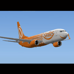
GOL Airlines " SMILE ", TRANSAVIA, ALASKA AIRLINE " Employee Powered " texture set for the TDS Boeing 737-800 (not included, must download base package). Model developed by Tenkuu Developers Studio, features high resolution textures, dynamic flexing wings, nose gear steering, rudder lock, ground spoilers, low speed aileron locks at high speed, fully animated control surfaces, fully independent suspension, trim animation, opening passenger doors, rolling wheels, animated thrust reversers with reverser block doors, detailed textures, full night lighting, ground service vehicles and more. Model design by Hiroshi Igami. Flight dynamics design by Nick Wilkinson, with assistance from David Biggar. Master textures and paint kit by Kyle Schurb. Painted by Triadi Sudarmawan for the great TDS model. Also works with FS2004.
| Filename: | GOL_Airlines__Smile__Transavia_Alaska_Airlines__Bo.zip |
| License: | Freeware |
| Added: | 23rd February 2014, 08:55:14 |
| Downloads: | 690 |
| Author: | Triadi Sudarmawan |
| Size: | 12.45 MB |
| Category: Flight Simulator 2004 - Scenery | |
| 9A8 - Ugashik, PAII - Egegik, AK96 - Bartletts, AK36 - Coffee Point , Alaska, USA |
|
Images related to this file:
File Description:
All four of these depend heavily on fishing but two of them only spring into existance during the salmon catching-and-canning season. Grant Air run scheduled flights to the two permanent settlements, and there are irregular scheduled flights and charters to the others according to demand. Ugashik is a permanent settlement 60 miles northeast of Port Heiden, stretched out along the east bank of the Ugashik River. There are two canneries, one old and collapsing and the other newer and functioning. The population is given as 12, though during the season this increases significantly. The (newer) airfield is at the northern end of the village with a gravel runway 3,500 feet long aligned 06-24. Egegik is the second permanent settlement, 45 miles north of Ugashik and 40 miles southwest of King Salmon, on the east bank of the Egegik River. The town is on a corner of land, with a population of around 110 and two operating canneries. The airport is a mile and a half south of the town with two gravel runways, 12-30 at just under 5,600 feet and 03-21 with 1,500 feet; both are lit. On the other side of the Egegik River are more canneries and two airfields, both of which have two runways but are otherwise entirely without facilities or luxuries such as lights. They are called Bartletts (named for the cannery it serves) and Coffee Point (named for the location). The shacks of the seasonal fishermen are strung out along the coast and a lot of the salmon fishing is by net, laid by a small boat and later pulled ashore for emptying. Only one cannery on the west shore has a docking facility for unloading boat-caught fish.
| Filename: | 9A8__Ugashik_PAII__Egegik_AK96__Bartletts_AK36__Co.zip |
| License: | Freeware, limited distribution |
| Added: | 3rd April 2015, 18:06:49 |
| Downloads: | 1,135 |
| Author: | Roger Wensley |
| Size: | 4.98 MB |
| Category: Flight Simulator 2004 - Scenery | |
| Bethel area airfields in southwest Alaska close to the Yukon River |
|
Images related to this file:
File Description:
This presumes you have already installed my post of Bethel PABE. In the Yukon River area of Alaska there are a lot of small villages close together, which is unusual for Alaska. Almost all of them are on the coast or a river bank, and the local economies depend on fishing. Some are larger than others and have a fish processing plant, such as in Emmonak. This is the largest such plant and it exports prepared fish by cargo planes which fly in on a daily basis, using an extended runway. This post includes airfields to the south and west of PABE, 17 of them; some of them already included and now modified. There will be more airfields to the north and northwest of Bethel in a future post. There are revisions to Bethel to include parking spaces for Yute Air (newly included here) and extra spaces for Ryan Air. Both of these flew Cessna 205 planes into the smaller village strips from Bethel (past tense as Yute Air recently went bankrupt). The northwest area is served both from Bethel and also from St Mary's PASM, which is in the northwest and at a more economical range to the local airfields (100 miles closer than Bethel). These smaller airfields have few airfield buildings or any other creature comforts; featuring heavily are a new standard blue garage building (sometimes not yet installed) and a small and old terminal shed (that has sometimes collapsed and been removed). Go to "http://vfrmap.com/" for free vfr maps of the area, There is a pic of the local chart area included here. The screenshots are a random sample. Kipnuk PAKI is the one that appears to have a second and long grass runway; what it actually has is the ground prepared for a new and long gravel runway but which hasn't been started yet as it has taken 10 years just to prepare the ground. I have no idea why.
| Filename: | Bethel_area_airfields_in_southwest_Alaska_close_to.zip |
| License: | Freeware, limited distribution |
| Added: | 16th April 2019, 22:47:47 |
| Downloads: | 155 |
| Author: | Roger Wensley |
| Size: | 5.93 MB |
| Category: Flight Simulator 2004 - Scenery | |
| St Michael Island in Alaska-St Michael 5S8 and Stebbins WBB |
|
Images related to this file:
File Description:
St Michael Island is 50 miles southwest of Unalakleet, an island that in fact appears to be a cape and a firmly attached piece of the mainland. On the island there are two villages, St Michael on the northeast corner and Stebbins on the northwest. St Michael has a new airfield that is west of the village by around a mile or so, with a gravel runway 4,000 feet long. The old and now closed airport was known as SMK, and is now readily identifiable by the new red-roofed school building that occupies the centre of the runway. The new airfield now has an icao code of PAMK, but FS9 does not readily accept icao code changes so we are stuck with the original code it was given, 5S8. The SMK icao of the old airport will still show on your gps as if I deleted it the runway would also have to be deleted, and a substitute and unsatisfactory gravel apron made to impersonate a runway. Stebbins is 5 miles west of St Michael and next to the shore, a smaller village than St Michael with around 250 inhabitants. The airfield is at the southern end of the village and has a gravel runway that is 3,000 feet long. The icao code is WBB. There is no AI included here as it was already included in the post of Shaktoolik. There is a correction here for Shaktoolik, which I now find should have had a blue garage, not a red one; I wrongly named a photo. A note here about my scenery making. This is post number 501 and there will not be many more to follow this as I am almost at the end of the photos I took or found for scenery purposes. There is a limit to what can be located online and I have already been making use of the little there is; eg Unalakleet. So, if you are near an airfield (preferably Canadian or Alaskan) and have a camera..... Let me know.
| Filename: | St_Michael_Island_in_AlaskaSt_Michael_5S8_and_Steb.zip |
| License: | Freeware, limited distribution |
| Added: | 1st August 2019, 16:45:58 |
| Downloads: | 95 |
| Author: | Roger Wensley |
| Size: | 3.88 MB |


© 2001-2026 AVSIM Online
All Rights Reserved
Privacy Policy |