
Where Flight Simulation Enthusiasts Gather from Around the World!
AVSIM Library - Search Results

| Category: Flight Simulator 2004 - Scenery | |
| Peawanuck CYPO / Winisk CYWN - Northern Ontario, Canada |

|
Images related to this file:
File Description:
Peawanuck is on the bank of the Winisk River, 23 miles upstream from where the river empties into the Hudson Bay just west of James Bay. It has a population of around 240, and was established in 1986 when the original settlement (Winisk) at the mouth of the river was destroyed by a flood. The airport is on a bluff in a corner of the river at 171 feet ASL, with a gravel runway just over 3,500 feet long and aligned 11-29. There is only basic runway lighting, with no ILS, VASI, or PAPI; there is also no apron lighting, or fuel. Service is provided by Air Creebec with connector flights to Moosonee and Timmins, and on to Montreal. A search of their timetable did not provide any information regarding timings but I made the AI flight from Timmins a daily one; it is probably only once or twice a week. There is also a daily private Cessna from Moosonee. Winisk, at the mouth of the river, has another gravel runway which is over 6,000 feet long. There is also a large hangar and to the north the remaining buildings and fuel tanks etc of a Radar Control site which was closed in 1965 after only 7 years of use.
| Filename: | Peawanuck_CYPO__Winisk_CYWN__Northern_Ontario_Cana.zip |
| License: | Freeware, limited distribution |
| Added: | 29th December 2012, 09:14:03 |
| Downloads: | 281 |
| Author: | Roger Wensley |
| Size: | 2.61 MB |
| Category: Flight Simulator 2004 - AI Aircraft | |
| Air Canada Express opb EVAS Air B1900D |
|
Images related to this file:
File Description:

Air Canada Express opb EVAS Air B1900D - HTAI AI Beechcraft 1900D //
Flightplans are available on AVSIM.
This works for both FS9 and FSX. Tested in FSX. FS9 model used.
For FSX users; you may have to UNCHECK "Aircraft casts shadows on the ground" under the
Aircraft - Exterior Settings in FSX to make any FS9-based model visible during the day!
Texture quality; 32Bit with alpha. FSX Native: DDS DXT5 with alpha. FS9 Native: BMP DXT3 with alpha.
FSX Light Fix included in the DDS night texture.
Included repaint is for the following model; AI Beechcraft 1900D from HTAI.
| Filename: | Air_Canada_Express_opb_EVAS_Air_B1900D.zip |
| License: | Freeware, limited distribution |
| Added: | 20th January 2013, 18:04:44 |
| Downloads: | 2,645 |
| Author: | Stephan Faessler / ImpulseAI |
| Size: | 2.7 MB |
| Category: Flight Simulator 2004 - Scenery | |
| Lady Franklin Point CWLF in Nunavut, Canada |
|
Images related to this file:
File Description:
Lady Franklin Point was a DEW line station on the southwest corner of Victoria Island, and then a North Warning System station until January 2000 when there was a fire. As a result there are now no NWS buildings, and no central long DEW line station building, only the outlying and already unused buildings from the DEW line site. However, the runway is still there and over 5,000 feet of gravel in length, aligned and signed 90T/270T, though on the atc it will be called 55/235 as FS9 knows nothing about the Canadian Northern Domestic Airspace. There is no runway lighting. Kugluktuk is around 80 miles to the southwest, on the mainland.
I should have mentioned a long time ago that to see the apron lights working (on my fields that HAVE apron lights) requires you to have the "lights_ss_v2" by Sidney Schwartz installed.
| Filename: | Lady_Franklin_Point_CWLF_in_Nunavut_Canada.zip |
| License: | Freeware, limited distribution |
| Added: | 10th November 2012, 04:04:06 |
| Downloads: | 260 |
| Author: | Roger Wensley |
| Size: | 1.81 MB |
| Category: Flight Simulator 2004 - Scenery | |
| Jenny Lind Island CWJL in Nunavut, Canada |
|
Images related to this file:
File Description:
This was a DEW line Auxiliary Station on Jenny Lind Island; the island is about 14 miles by 12 miles and off the southeast corner of Victoria Island, 85 miles east of Cambridge Bay. The station was closed in 1992 but is still there as "closed" meant "shut the door and walk away". There has been some later removal of diesel tanks and other polluting items but the buildings are still intact, and the runway is 4,470 feet of gravel 150' wide. At the western end there is an apron and a large hangar. There are of course no lights, signage, or windsock. A North Warning System station was built in 1990, 6 miles inland to the northwest of the runway. This has a shorter (1,400'?) gravel runway (and named CWJX here).
| Filename: | Jenny_Lind_Island_CWJL_in_Nunavut_Canada.zip |
| License: | Freeware, limited distribution |
| Added: | 15th November 2012, 13:55:29 |
| Downloads: | 190 |
| Author: | Roger Wensley |
| Size: | 1.65 MB |
| Category: Flight Simulator 2004 - Scenery | |
| Waskaganish CYKQ in northern Quebec, Canada - revised |
|
Images related to this file:
File Description:
Waskaganish is at the southern end of James Bay, in Quebec, and this is a revised version. It deletes a hold short that should not have been showing on the gravel, and adds in signage, runway lights, taxiway lights, terminal night textures, and revised AI. I have no idea why I didn't include the night textures before. It presumes you have already installed my October 2010 Waskaganish.
| Filename: | Waskaganish_CYKQ_in_northern_Quebec_Canada__revise.zip |
| License: | Freeware, limited distribution |
| Added: | 6th January 2013, 00:08:58 |
| Downloads: | 222 |
| Author: | Roger Wensley |
| Size: | 1.49 MB |
| Category: Flight Simulator 2004 - Scenery | |
| Eastmain River CZEM in northern Quebec, Canada |
|
Images related to this file:
File Description:
Eastmain River is on the south bank of the river of the same name, close to the eastern shore of James Bay at it's southern end. Moosonee is around 110 miles to the southwest, and Waskaganish (my post October 2010) just 50 miles to the south. The town has a population of around 770 who are mostly Cree speakers. The airport is just to the south of the town with a gravel runway just over 3,500 feet long and aligned 02/20; there is no PAPI and there is no fuel available, unless there is some in drums. There are flights by Air Creebec and Wasaya; their textures are available for download on Flightsim and the planes are as listed in the AI folder. The AI bgl is for both CYAT and CZEM; don't think I have included the wrong one.
| Filename: | Eastmain_River_CZEM_in_northern_Quebec_Canada.zip |
| License: | Freeware, limited distribution |
| Added: | 10th January 2013, 22:00:34 |
| Downloads: | 252 |
| Author: | Roger Wensley |
| Size: | 2.14 MB |
| Category: Flight Simulator X - AFCAD Files | |
| CYQB - Quebec Jean-Lesage Intl. - Canada v3.0 |
|
Images related to this file:
File Description:
This AFCAD file add a new taxiway that connect Taxiway DELTA to Taxiway GOLF.This new infrastructure, approximately 900m in lenght is parallel to the main runway (06-24) improve access to Apron 1 and the runways, minimizing the need to use Runway 12-30 as a taxiway. It will also be used by aircraft leaving the de-icing centre that will be build in a near futur.
It also include the extension of RAMP #3
| Filename: | CYQB__Quebec_JeanLesage_Intl__Canada_v30.zip |
| License: | Freeware |
| Added: | 25th March 2013, 05:28:46 |
| Downloads: | 1,222 |
| Author: | Gilles Boily |
| Size: | 142.3 KB |
| Category: Flight Simulator 2004 - Scenery | |
| Paulatuk CYPC in the Northwest Territories, Canada |
|
Images related to this file:
File Description:
Paulatuk is on the coast of northern mainland Canada, 200 miles east of Tuktoyaktuk and 170 miles southwest of Ulukhaktok. It is just to the east of the Parry Peninsula, which has at its northern tip the Cape Parry DEW line Main Station. Paulatuk was established in the 1920's, and the population now numbers around 320. Paulatuk airfield is close to the village but on higher ground, while the village follows the curve of the coast. The 4,000 feet of 100 feet wide gravel runway is aligned 021T/201T where T stands for "true" as opposed to magnetic in the Northern Domestic Airspace. Only JETA-1 is available unless there is 100LL in drums. There are flights by Aklak Air from Inuvik, which is around 250 miles to the west; Aklak Air is actually Kenn Borek under a diferent name. The AI is for a daily passenger flight, and for a cargo flight on Wednesdays. In the summer, float planes use the lake to the south of the village, but I have no information as to docks or any other facilities; probably there aren't any.
| Filename: | Paulatuk_CYPC_in_the_Northwest_Territories_Canada.zip |
| License: | Freeware, limited distribution |
| Added: | 3rd December 2012, 21:58:47 |
| Downloads: | 278 |
| Author: | Roger Wensley |
| Size: | 4.39 MB |
| Category: Flight Simulator X - Aircraft Repaints, Textures and Modifications | |
| Seaborne Airlines deHavilland Canada DHC6-300 - Wheeled |
|
Images related to this file:
File Description:
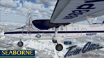
Repaint of Aerosoft DHC6-300 wheeled in Seaborne livery. Textures only.
| Filename: | Seaborne_Airlines_deHavilland_Canada_DHC6300__Whee.zip |
| License: | Freeware |
| Added: | 4th February 2014, 08:45:35 |
| Downloads: | 242 |
| Author: | Rob Potter |
| Size: | 4.02 MB |
| Category: Flight Simulator 2004 - Scenery | |
| Dawson Creek CYDQ in British Columbia, Canada |
|
Images related to this file:
File Description:
Dawson Creek is at 2,148 feet asl just east of the Rocky Mountains, less than 10 miles west of the BC/Alberta border. The Peace River, 25 miles north of Dawson Creek, links the two sides of the Rockies, winding through peaks that reach up almost to 8,000 feet. The population grew when the Northern Alberta Railway was extended to Dawsons Creek in 1932, and grew even more more when the Alaska Highway was built in 1942 and Dawsons Creek was where it started from. The airport is just to the east of the town. The runway is 5,000 feet of wide asphalt (150 feet) aligned 06/24, lit, and with PAPI and approach lights. There is a water runway to the north of the main runway with the same alignment, separately designated as Dawson Creek CBD3. The two operate as one; traffic for both use the mandatory frequency of 122.2 and talk to one controller in one control tower. However, in FS9 the ATC for two separately designated airfields operates as if they are nowhere near each other and near misses are the result. I have put them both in un-manned tower mode so you will announce your position and intentions and select your own parking spots etc. There is in reality a lack of apron markings but I have marked the positions of both gates. The apron is not large so there is only one other apron parking spot (see the traffic cone) and most parking is either next to one of the hangars or on the grass. The aprons vary from asphalt, to concrete, onwards to gravel, and then further onwards to some gravel amid the bare dirt; I have replicated this variation as far as FS9 permits. The buildings are bespoke from photos. The AI includes Central Mountain Air with two daily scheduled flights and Northern Cariboo as one of the airlines that occasionally runs charter flights in CYDQ. There are also private GA flights, and float plane flights into and out of CBD3.
| Filename: | Dawson_Creek_CYDQ_in_British_Columbia_Canada.zip |
| License: | Freeware, limited distribution |
| Added: | 22nd November 2013, 23:31:40 |
| Downloads: | 653 |
| Author: | Roger Wensley |
| Size: | 16.65 MB |


© 2001-2026 AVSIM Online
All Rights Reserved
Privacy Policy |