
Where Flight Simulation Enthusiasts Gather from Around the World!
AVSIM Library - Search Results

| Category: Flight Simulator 2004 - Scenery | |
| Puvirnituq CYPX in Hudson Bay, Quebec, Canada |

|
Images related to this file:
File Description:
Puvirnituq is a village of 1,300 or so inhabitants at N60 W77 on the east shore of Hudson Bay. It's name means "Putrid" in Inuit, and there are two different stories about how it got the name. The village does not feature in FS9, but is included in this scenery with approximately the right shape (the coast, even with UT, is not exactly right) so just think of it as a hand-made auto-generated village which gives the airfield a reason for being there. The runway is a very generous 6,300 feet of gravel 148 feet wide, which should be enough for almost anything. I also had to add the roads, delete the stock airfield background and add a new background, plus of course there is the scenery file and the AFCAD and AI.
| Filename: | Puvirnituq_CYPX_in_Hudson_Bay_Quebec_Canada.zip |
| License: | Freeware, limited distribution |
| Added: | 30th October 2010, 13:34:30 |
| Downloads: | 375 |
| Author: | Roger Wensley |
| Size: | 1.72 MB |
| Category: Flight Simulator 2004 - Scenery | |
| Ivujivik CYIK in Hudson Bay, Quebec, Canada |
|
Images related to this file:
File Description:
Ivujivik is a village of 350 or so inhabitants at N62 25 W78 on the northeastern corner of Hudson Bay. The village does not feature in FS9 but is included in this scenery with approximately the right shape (the coast, even with UT, is not exactly right) so just think of it as a hand-made auto-generated village which gives the airfield a reason. The runway is 3,500 feet of gravel 100 feet wide, which should be enough. I also added the roads, deleted the stock airfield background and added a new background, plus of course there is the scenery file and the AFCAD and AI. You may note that the terminal has the elevation written on the sign as 126', while on the winter photo it is written on the older & bigger sign as 130'. I thought this is because satellite radar has fixed the elevations of all airfields more accurately than before, as Rockcliffe too has gone from 192' to 188'; the alternative explanation is that global warming has raised sea level by 4'. Wow! That's a thought. I presume the new sign was made smaller as a cost saving.
| Filename: | Ivujivik_CYIK_in_Hudson_Bay_Quebec_Canada.zip |
| License: | Freeware, limited distribution |
| Added: | 31st October 2010, 07:41:20 |
| Downloads: | 458 |
| Author: | Roger Wensley |
| Size: | 2.07 MB |
| Category: Flight Simulator 2004 - Scenery | |
| Salluit CYZG in Hudson Strait, Quebec, Canada |
|
Images related to this file:
File Description:
Salluit is a village of 1,250 or so inhabitants at N 62 W 75 40 on the shore of Sugluk Inlet, which is off Hudson Strait. It's name means "Skinny Ones" in Inuit, and refers to a time when there was not enough to eat, which is a rather scary reminder of just how fragile Inuit survival used to be. The village does not feature in FS9 but is included in this scenery with approximately the right shape and with the roads that lead to the airfield and what I presume are quarries for building materials and roads. The airfield runway is 3,510 feet of gravel 100 feet wide and is some 740 feet higher than the village on the shoreline. I added the roads, the quarries, a new airfield background, plus of course there is the scenery file and the AFCAD and AI.
| Filename: | Salluit_CYZG_in_Hudson_Strait_Quebec_Canada.zip |
| License: | Freeware, limited distribution |
| Added: | 2nd November 2010, 01:18:55 |
| Downloads: | 373 |
| Author: | Roger Wensley |
| Size: | 1.96 MB |
| Category: Flight Simulator 2004 - Original Aircraft | |
| de Havilland of Canada U-6A Beaver |
|
Images related to this file:
File Description:
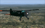
From 1952-1960, De Havilland Aircraft of Canada manufactured the U-6A (designated L-20 until 1962), delivering nearly 1,000 to the United States' armed services. Although flown mostly by the U.S. Army, the U.S. Air Force employed more than 200 U-6As, primarily for aeromedical evacuation. However, the USAF also used the U-6A aircraft for courier service, passenger transport, light cargo, reconnaissance, rescue and aerial photography missions. The U-6A saw USAF service in both the Korean and Southeast Asia Wars.
| Filename: | de_Havilland_of_Canada_U6A_Beaver.zip |
| License: | Freeware |
| Added: | 13th August 2010, 22:19:37 |
| Downloads: | 1,415 |
| Author: | Peter Mercy / John L Woodward |
| Size: | 22.38 MB |
| Category: Flight Simulator 2004 - Scenery | |
| Quaqtaq CYHA in Hudson Strait, Quebec, Canada |
|
Images related to this file:
File Description:
Quaqtaq is a small village of 310 or so inhabitants at N 61 W 69 37 on the Hudson Strait at the northwest corner of Ungava Bay. It's name has some connection with "tapeworm" in Inuit; there is a story but I won't recount it here. The village does not feature in FS9 but is included in this scenery with approximately the right shape. No village buildings were specifically modeled; they are hand-made non-specific village houses typical of the north. The airfield runway is 3,520 feet of gravel 100 feet wide and is at 103 feet above the shoreline. I added the roads, a new airfield background, plus of course there is the scenery file and the AFCAD and AI, which is an Air Inuit Dash 8-300. This is the last of a series in northern Quebec that all have similar terminal buildings; I know of others which have the same type of building but I have no photos to discover the differences.
| Filename: | Quaqtaq_CYHA_in_Hudson_Strait_Quebec_Canada.zip |
| License: | Freeware, limited distribution |
| Added: | 8th November 2010, 04:29:39 |
| Downloads: | 414 |
| Author: | Roger Wensley |
| Size: | 2 MB |
| Category: Flight Simulator 2004 - Scenery | |
| 14 Wing Greenwood Nova Scotia (CYZX), Canada |
|
Images related to this file:
File Description:
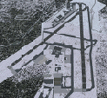
Re-upload. 14 Wing Greenwood, home of the CP-140 Aurora and 413 Search and Rescue Squadron.
Scenery includes a detailed airport.
| Filename: | 14_Wing_Greenwood_Nova_Scotia_CYZX_Canada.zip |
| License: | Freeware, limited distribution |
| Added: | 2nd January 2011, 03:57:09 |
| Downloads: | 2,727 |
| Author: | Serge Duguay |
| Size: | 4.03 MB |
| Category: Flight Simulator X - Aircraft Repaints, Textures and Modifications | |
| Air Canada Airbus A330-300 (C-GHKX) |
|
Images related to this file:
File Description:

Textures only, Wilco/FeelThere Airbus Series Vol 2 required. Follow Readme for easy installation instructions. (Re-upload)
| Filename: | Air_Canada_Airbus_A330300_CGHKX.zip |
| License: | Freeware |
| Added: | 8th September 2010, 09:51:19 |
| Downloads: | 4,743 |
| Author: | Robert Halmich, Wilco FeelThere |
| Size: | 856.55 KB |
| Category: Flight Simulator X - Scenery | |
| Riviere-du-Loup Airport (CYRI) Quebec, Canada |
|
Images related to this file:
File Description:
This scenery is a rendition of the Riviere-du-Loup (CYRI) airport using Gmax. Information available in the latest official aeronautical publications and several pictures were used as guide in order to reproduce buildings and other custom 3D objects as accurately as possible without sacrificing the FPS.Also includes landclass definition of the area.
| Filename: | RiviereduLoup_Airport_CYRI_Quebec_Canada.zip |
| License: | Freeware |
| Added: | 16th January 2011, 02:48:16 |
| Downloads: | 3,155 |
| Author: | Pierre Gallant |
| Size: | 4.39 MB |
| Category: Flight Simulator X - AI Aircraft | |
| Air Canada Boeing 777-300 ER GE |
|
Images related to this file:
File Description:

Update. Boeing 777-300 ER GE in Air Canada livery (ICAO: ACA); aircraft's registration: C-FIUL. Textures are photoreal and meant to be used with the B773 ER GE model (v3) made by FSPAP - FSPainter Advanced Product (basepacks "fsp777v3_050701.zip" and "fsp_b777v3_fd_update_050705.zip"). Extremely well modeled and at the same time framerate friendly, this B777-300 is one of the best freeware airplanes for AI traffic available on the market. On my website you can also find Air Canada's B777-200 LR GE "C-FIUA"; for more photoreal liveries visit my website www.skycolors.com.
| Filename: | Air_Canada_Boeing_777300_ER_GE.zip |
| License: | Freeware |
| Added: | 17th February 2011, 20:59:06 |
| Downloads: | 7,992 |
| Author: | Claudio Adriano Dobre / SKYCOLORS.com |
| Size: | 1.1 MB |
| Category: Flight Simulator 2004 - Scenery | |
| St Andre-Avellin CAA2 in Quebec Canada |
|
Images related to this file:
File Description:
St Andre-Avellin is a new airfield in Quebec Canada, 35 miles east of Ottawa and 10 miles north of the Ottawa River, and just northwest of the village of the same name. There is a 03/21 grass runway that is 2,870 feet long and slopes up towards the north. To show this slope I have not "placed" a grass runway (which would immediately flatten the slope) and anway there is not so much traffic that the grass would be notably marked. Because of the lack of an FS-recognised runway I have not made parking or a traffic file as AI would not work; anyway this airfield with constant activity would not reflect reality. There are no facilities at the airfield except a hangar for the owner and space to park.
| Filename: | St_AndreAvellin_CAA2_in_Quebec_Canada.zip |
| License: | Freeware, limited distribution |
| Added: | 9th April 2011, 20:49:47 |
| Downloads: | 168 |
| Author: | Roger Wensley |
| Size: | 816.9 KB |


© 2001-2026 AVSIM Online
All Rights Reserved
Privacy Policy |