
Where Flight Simulation Enthusiasts Gather from Around the World!
AVSIM Library - Search Results

| Category: Flight Simulator X - Scenery | |
| CYNA Canada, Quebec, Natashquan |

|
Images related to this file:
File Description:
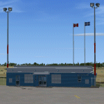
This scenery represents as much as possible the airport of Natashquan (CYNA). However, certain frontages of the buildings can farier, not having had the authorization to take photographs on the ground. This scene was built with FSDS and it is compatible for FS-X. Natashquan is located at Quebec, Canada on banks of the St-Laurent river. It is a small village of the Cote-Nord.
| Filename: | CYNA_Canada_Quebec_Natashquan.zip |
| License: | Freeware |
| Added: | 31st December 2009, 04:53:21 |
| Downloads: | 1,250 |
| Author: | Regis Dassylva |
| Size: | 4.53 MB |
| Category: Flight Simulator X - Scenery | |
| CTH3 Canada, Quebec, Les Grandes-Bergeronnes |
|
Images related to this file:
File Description:
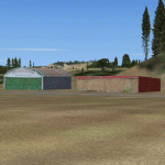
This is the scenery Les Grandes Bergeronnes ( CTH3 ) which represents the reality. Les Grandes Bergeronnes is a small village located on Northern bank of the St-Laurent river of Quebec at Canada. This scenery is design with FSDS and it accepts Mesh of Gilles Gauthier.This scenery has the function for FS-X.
| Filename: | CTH3_Canada_Quebec_Les_GrandesBergeronnes.zip |
| License: | Freeware |
| Added: | 2nd January 2010, 04:37:53 |
| Downloads: | 849 |
| Author: | Regis Dassylva |
| Size: | 1.62 MB |
| Category: Flight Simulator X - Scenery | |
| FSX ANTIGUA scenery Correct Effect bug (error manipulation) |
|
File Description:
FSX Correct bug Effect on ANTIGUA scenery (error manipulation)
| Filename: | FSX_ANTIGUA_scenery__Correct_Effect_bug_error_mani.zip |
| License: | Freeware |
| Added: | 20th January 2010, 01:39:23 |
| Downloads: | 2,516 |
| Author: | valladier Jean Louis |
| Size: | 129.64 KB |
| Category: Flight Simulator X - Scenery | |
| Whale Island (Hi Resolution Photo and mesh), New Zealand |
|
Images related to this file:
File Description:
Whale Island (Maori Name: Moutohora) is a small island located off the Bay of Plenty coast of New Zealand's North Island. It is located about 12 kilometers north of the town of Whakatane. A whaling station existed on the island during the 19th century. The 1.43 km island is a remnant of a complex volcano which has eroded, leaving two peaks. This is still an area of volcanic activity and there are hot springs on the island in Sulphur Valley, McEwans Bay, and Sulphur Bay.
This Hi Resolution scenery was created from a 0.25m pixel resolution Ortho-rectified Aerial mosaic owned by Environment Bay of Plenty (The Bay of Plenty Regional Council) and flown in 2007. The imagery has been slightly de-sampled for use in Flight Simulator X and utilizes the a custom hi resolution 5m Mesh derived from photogrammetry data off the photos. The textures are intended for summer daylight flying only, although due to the evergreen nature of New Zealand's native bush, the Islands appearance remains relatively constant throughout the year.
The island contains a small helicopter pad which is used for checking the various radio antennas on the Island. There is also a small Department of Conservation hut near the south western tip of the Island. These objects have been added from the FSX library of objects. Make sure to turn up your graphics sliders to make the most of this data! To find the Island fly north from Whakatane airport.
| Filename: | Whale_Island_Hi_Resolution_Photo_and_mesh_New_Zeal.zip |
| License: | Freeware, limited distribution |
| Added: | 20th January 2010, 10:12:14 |
| Downloads: | 4,650 |
| Author: | Tim Barnes |
| Size: | 9.94 MB |
| Category: Flight Simulator X - Scenery | |
| Naka Sapporo City |
|
File Description:
It is the building built in Gmax of Japanese Sapporo City for FSX.
And two years hung to the completion.
Though originally it is being made in accordance with Sapporo Photo Scenery of the Photecs company.
There is no problem even in VirtualEarth (Example1) of TileProxy, and it can use.
As for the smoke of the cleaning factory and a firework and Effect such as a fountain, readme of another attachment. txt
Refer to it.
Most Texture is very beautiful when it approaches because it spends about two years and it is made and it is being made by the photograph.
But, even my PC can be blown off somehow though it is very heavy because there are many buildings very much.
| Filename: | Naka_Sapporo_City.zip |
| License: | Freeware |
| Added: | 21st January 2010, 01:06:27 |
| Downloads: | 1,502 |
| Author: | Harutoshi Nakagawa |
| Size: | 76.28 MB |
| Category: Flight Simulator X - Scenery | |
| Lighthouses of St-Lawrence river, Quebec |
|
Images related to this file:
File Description:
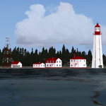
Near 30 lighthouse and beacon sites from Quebec (CYQB) to Perce (near CYGP) and to Havre-St-Pierre (CYGV).
| Filename: | Lighthouses_of_StLawrence_river_Quebec.zip |
| License: | Freeware |
| Added: | 22nd January 2010, 00:21:01 |
| Downloads: | 2,305 |
| Author: | Jean-Pierre Fillion |
| Size: | 1.41 MB |
| Category: Flight Simulator X - Scenery | |
| Sarasota-Bradenton (KSRQ) - Fix |
|
File Description:
An ADE software update occurred during the development of scenery for Sarasota/Bradenton, and it has now become apparent that runway approach altitudes were lost when the old ADE file was opened with the new version. This will cause ATC to direct aircraft to make their approaches at altitude 0, and AI will taxi to the runways from miles away. If you have this scenery (sarasota-bradenton_fl.zip in the AVSIM library), substitute this .bgl file to correct the problem.
| Filename: | SarasotaBradenton_KSRQ__Fix.zip |
| License: | Freeware |
| Added: | 23rd January 2010, 11:14:01 |
| Downloads: | 1,233 |
| Author: | Art Poole |
| Size: | 24.76 KB |
| Category: Flight Simulator X - Scenery | |
| Sunset Point |
|
File Description:
A fictitious Sunset Point located 58 NM south-east of Juneau Int'l airport with VOR/DME @ 115.100, a water landing and helipad, Sunset Point Lodge, cabin rentals and great fishing. Various FS candies located around the area and a great place to stop over or stay awhile. Created with Instant Scenery and default FSX 3D objects. Designed with bush pilots in mind and enhancing your bush flying in the great state of Alaska. Enjoy! By Savageagle
| Filename: | Sunset_Point.zip |
| License: | Freeware |
| Added: | 24th January 2010, 11:16:42 |
| Downloads: | 664 |
| Author: | Tim Durham |
| Size: | 714.96 KB |
| Category: Flight Simulator X - Scenery | |
| CYUL - TSC Building Logo - FIXED |
|
Images related to this file:
File Description:
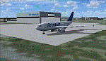
For owners of Blueprint Simulations CYUL Scenery, this will place Air Transat's logo on their maintenance building.
That building is very recognisable due to the logo, which is in proximity of Highway 13, which sees a lot of traffic. The most used approach at CYUL is 24R,and this building is located right next to it, so it will give you an even better feel that you are about to touch ground in Montreal!
Fixed the file, as i had zipped a wrong file. put CYUL_TSC_LIB.BGL instead of CYUL_TSC_LOGO.BGL.
It now works.
NOTE: This file does not alter Blueprint's files, it is completely separate, but must be put in Blueprint's CYUL directory to work. Enjoy!
| Filename: | CYUL__TSC_Building_Logo__FIXED.zip |
| License: | Freeware |
| Added: | 26th January 2010, 04:14:58 |
| Downloads: | 951 |
| Author: | Brian Paquette |
| Size: | 666.14 KB |
| Category: Flight Simulator X - Scenery | |
| Summit Lake_FSX.zip |
|
File Description:
This is a small upgrade to Summit Lake 52Z. Includes float plane and fueling docks, private home, cabins around the lake, a smaller home/maintenance shop and sheds and 2 jeeps. Default FSX objects used with Instant Scenery. Summit Lake is ESE of PANC. enjoy your stops at Summit Lake. Done by savageagle.......Enjoy!
| Filename: | Summit_Lake_FSXzip.zip |
| License: | Freeware |
| Added: | 28th January 2010, 14:58:33 |
| Downloads: | 487 |
| Author: | Tim durham |
| Size: | 266.23 KB |


© 2001-2026 AVSIM Online
All Rights Reserved
Privacy Policy |