
Where Flight Simulation Enthusiasts Gather from Around the World!
AVSIM Library - Search Results

| Category: Flight Simulator 2004 - Scenery | |
| Lake Powell, Navajo Mountain (04UT), Utah/Arizona, Photo-Scenery (FS9 & FSX) |

|
Images related to this file:
File Description:
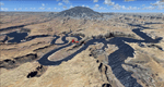
This package contains the center of Lake Powell and the Navajo Nation around Navajo Mountain. It contains remote areas of stunning beauty. Wonderful sandstone formations in bright shades of red and pink. Contains landmarks like the Rainbow Bridge National Monument and the confluence of the Colorado and San Juan Rivers. Extends my Monument Valley scenery to the west and brings you another 3.500 sq km in 4.7m/pix quality. To explore the scenery depart from Navajo Mountain dirt strip (04UT). High resolution versions of this scenery for FS9 and FSX (much sharper, but larger and multiple downloads) are available at www.blueskyscenery.com/CNY_South3West2.html . The screenies are taken from the high-res versions, so expect this version to be slightly more blurry. YourDonation@Work: Joaquin, Donald and Scott.
| Filename: | Lake_Powell_Navajo_Mountain_04UT_UtahArizona_Photo.zip |
| License: | Freeware, limited distribution |
| Added: | 23rd January 2010, 23:06:49 |
| Downloads: | 1,788 |
| Author: | Gottfried Razek - blueskyscenery.com |
| Size: | 91.43 MB |
| Category: Flight Simulator 2004 - Scenery | |
| Lleida Alguaire airport |
|
File Description:
This is the new LLeida Alguaire airport designed from pictures taken from the airport website.
| Filename: | Lleida_Alguaire_airport.zip |
| License: | Freeware |
| Added: | 24th January 2010, 22:21:10 |
| Downloads: | 809 |
| Author: | Angel Andreu |
| Size: | 94.3 KB |
| Category: Flight Simulator 2004 - Scenery | |
| AI Helicopters for Penticton, British Columbia, Canada. |
|
Images related to this file:
File Description:

AI Helicopters for Penticton, British Columbia, Canada. This package is designed to compliment the exceptionaly fine enhancement of the airport (CYYF) by John Stinstrom. Featured are three repaints by John Burford of the Sikorsky S-76 AI Helicopter in Canadian Helicopter's colors. The AI Helicopter model by Chris "Elvis" Jones is not included but download details for it and other suggested enhancements are included in the documentation. The project uses the "invisible" airport and "forward departure" (no push-backs) techniques. Please unzip to a temporary folder and follow the very easy installation instructions. Compiled for your flying enjoyment by David "Opa" Marshall. ---
NOTE: This single package replaces three related files destroyed in the May hack upon Avsim.
| Filename: | AI_Helicopters_for_Penticton_British_Columbia_Cana.zip |
| License: | Freeware |
| Added: | 28th January 2010, 14:57:01 |
| Downloads: | 4,899 |
| Author: | David "Opa" Marshall & John Burford |
| Size: | 837.98 KB |
| Category: Flight Simulator 2004 - Scenery | |
| Terrain Mesh (LOD08) for Nunavut, Canada (File 3 of 4) |
|
File Description:
Re-upload. The files in this package contain a new 153m (LOD08) terrain mesh for Nunavut, Canada ( and northern part of Northwest Territories) to use with FS2002 and FS2004. The source data is GeoBase (CDED1 : 250 000). All data were compiled and edited in MicroDEM 7.01 alpha and resampled to LOD08 (Level of Details), or 152.88 meters horizontal resolution, with the Microsoft Terrain Software Developer's Kit (SDK) utilities. (Nunavut8a.zip, Nunavut8b.zip Nunavut8c.zip Nunavut8d.zip - 4 Parts).
| Filename: | Terrain_Mesh_LOD08_for_Nunavut_Canada_File_3_of_4.zip |
| License: | Freeware, limited distribution |
| Added: | 29th January 2010, 00:42:21 |
| Downloads: | 927 |
| Author: | Gilles Gauthier |
| Size: | 31.96 MB |
| Category: Flight Simulator 2004 - Scenery | |
| AI Water "aircraft" for Lake Okanagan, BC. |
|
Images related to this file:
File Description:
AI Water "aircraft" for Lake Okanagan, BC. This package features an AI Sternwheeler ship, an AI Waco Bi-wing plane and AI Cabin Cruisers set on Lake Okanagan, near Penticton and Kelowna, BC, Canada. Offerred as an interesting scenery enhancement, it also demonstrates the use of the "forward departure" (no push-back) technique as applied to water based aircraft. A few EZ objects have also been used to decorate the dock areas where the AI "craft" will be seen. This enhancement has been tested with the default FS2004 scenery only and may not work with other enhancements (such as UT-Canada) which alter the shorelines of Lake Okanagan. Other downloads may be required or are recommended. Complete details about these will be found in the instructions. Please unzip to a temporary folder and follow the easy installation instructions. Compiled for your flying enjoyment by David "Opa" Marshall.
-
NOTE: This package replaces the one which is missing due to the May hack on Avsim. Nothing new has been added.
| Filename: | AI_Water_aircraft_for_Lake_Okanagan_BC.zip |
| License: | Freeware |
| Added: | 29th January 2010, 21:28:38 |
| Downloads: | 1,464 |
| Author: | David "Opa" Marshall |
| Size: | 1.8 MB |
| Category: Flight Simulator 2004 - Scenery | |
| Aspen (KASE), Colorado, Photo-Scenery (FS9 & FSX) |
|
Images related to this file:
File Description:

There sure is more than one reason to go to Aspen and this is sure another must-have of my Colorado sceneries. If you're coming IFR there's a couple of very demanding approach procedures. From a LOC/DME to several visual approaches there's everything your heart might desire. Due to the steep and high surrounding terrain these are quiet some hair raisers (see www.airnav.com/airport/KASE). If you're coming VFR then the traffic pattern altitude is 9.005 ft for light aircraft (vs. 9.505 for aircraft 12.500 lbs or more). Weather and wind permitting, RW15 is preferred for all landings (left pattern). RW33 has a right pattern and is preferred for all takeoffs. You even need a written permission to depart RW15. When departing VFR make a right turn to a heading of 360 degrees ASAP for noise abatement and hold this heading for at least 2 miles from the field. And don't forget to enjoy the impressive mountain scenery with two 14ers: Snowmass Mtn. and Castle Pk. to the southwest. This scenery brings you another 3.500 sq km of beautiful Colorado in 4.7m/pix quality. High resolution versions of this scenery for FS9 and FSX (much sharper, but larger and multiple downloads) are available at www.blueskyscenery.com/GNB_South2West2.html . The screenies are taken from the high-res versions, so expect this version to be slightly more blurry. YourDonation@Work: Dedicated to Mark, Markus and Yves.
| Filename: | Aspen_KASE_Colorado_PhotoScenery_FS9__FSX.zip |
| License: | Freeware, limited distribution |
| Added: | 30th January 2010, 17:04:55 |
| Downloads: | 3,581 |
| Author: | Gottfried Razek - blueskyscenery.com |
| Size: | 92.5 MB |
| Category: Flight Simulator 2004 - Scenery | |
| Denali Park Research Base |
|
Images related to this file:
File Description:
A fictitious research base located 16 nautical miles west of Denali airport (AK06). It is owned and operated by NWS and used by several agencies including park service, various concessionaires, Fish and Game, Law enforcement and Medical/search and rescue agencies.
It has a runway only marked by barrels emitting heavy smoke along with crew barracks, main base building w/comm center, covered parking for snowcats and cargo/supplies. there are other buildings and a very large communications tower on the south side of the runway which parallels the river. It has an NDB of 351.2 (ADF).
Get hired to bring in cargo from Denali and other nearby airports. Made with Instant Scenery and various object libraries.
Best approach is from the north and the smoking barrels only mark a short section of the available landing area. Read the txt file for more info and have a great fly to the research base. By savageagle.
| Filename: | Denali_Park_Research_Base.zip |
| License: | Freeware |
| Added: | 1st February 2010, 09:35:25 |
| Downloads: | 279 |
| Author: | Tim Durham |
| Size: | 3.46 MB |
| Category: Flight Simulator 2004 - Scenery | |
| The Oregon Coast Scenic Railroad (OCSR) |
|
Images related to this file:
File Description:
The Oregon Coast Scenic Railroad. All aboard! This is a re-creation of the OCSR, which runs from Garibaldi, Oregon along the seashore to Rockaway Beach. It is designed to compliment the Tillamook, Oregon Airport scenery by John McKeon and David "Opa" Marshall (tills47.zip and tillup.zip - available here).
The project utilizes objects from selected EZ and RWY12 libraries as well as the new Railroad Object library by John McKeon (ezrrobjm.zip - also available here). If you have the LAGO FSE program you will be able to hear the Steam Train whistle and the nearby seagulls as files for these sounds are included. This scenery was designed to display properly in the default FS2004 environment. Please unzip to a temporary folder and follow the simple installation instructions. Compiled for your flying enjoyment by David "Opa" Marshall.
| Filename: | The_Oregon_Coast_Scenic_Railroad_OCSR.zip |
| License: | Freeware |
| Added: | 1st February 2010, 11:20:40 |
| Downloads: | 1,324 |
| Author: | David "Opa" Marshall |
| Size: | 3.45 MB |
| Category: Flight Simulator 2004 - Scenery | |
| McMinnville, Oregon - KMMV - Evergreen Museum, Home of the Spruce Goose |
|
Images related to this file:
File Description:
FS2004 Scenery - KMMV - Evergreen Museum. Located in the beautiful Willamette Valley, some 40 miles South of Portland, Oregon, McMinnville Municipal Airport (KMMV) serves McMinnville and Yamhill County and is owned by the City Of McMinnville, Oregon.
The airport is the home of the Cascade Soaring Club and Evergreen International, a global aviation services company. Adjacent to the airport is the new Evergreen Aviation Museum whose centerpiece is the famous "Spruce Goose".
This scenery includes a replica of the Museum and the new IMAX theater. Requires EZ Scenery Libraries. Installations included for default FS9 roads or for users who have USA Roads installed. Lago FSE optional. IMPORTANT!! PLEASE READ THE README FILE!!! Please unzip (using folders option) to a temporary folder. Created by John B. Loney, Jr and David "Opa" Marshall.
| Filename: | McMinnville_Oregon__KMMV__Evergreen_Museum_Home_of.zip |
| License: | Freeware |
| Added: | 1st February 2010, 11:37:39 |
| Downloads: | 2,584 |
| Author: | John B. Loney, Jr and David "Opa" Marshall |
| Size: | 4.07 MB |
| Category: Flight Simulator 2004 - Scenery | |
| Leadville (KLXV), Mt. Elbert, Colorado, Photo-Scenery (FS9 & FSX) |
|
Images related to this file:
File Description:
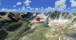
Extends my Aspen scenery to the east and contains more gorgeous Continental Divide area of the Rocky Mountains. Covers Leadville Lake County Airport (KLXV), which is the highest airport in North America (9.927 ft) and Mt. Elbert, which is the highest peak in the Rocky Mountains (14.443 ft). Aircraft performance deteriorates
with altitude, so many companies use the Leadville Airport as a base for high altitude performance testing. This scenery brings you another 3.500 sq km of beautiful Colorado in 4.7m/pix quality.
High resolution versions of this scenery for FS9 and FSX (much sharper, but larger and multiple downloads) are available at www.blueskyscenery.com/GNB_South2West.html . The screenies are taken from the high-res versions, so expect this version to be slightly more blurry. YourDonation@Work: Dedicated to Daniel, Art and Rotui.
| Filename: | Leadville_KLXV_Mt_Elbert_Colorado_PhotoScenery_FS9.zip |
| License: | Freeware |
| Added: | 1st February 2010, 19:06:58 |
| Downloads: | 1,712 |
| Author: | Gottfried Razek - blueskyscenery.com |
| Size: | 94.68 MB |


© 2001-2026 AVSIM Online
All Rights Reserved
Privacy Policy |