
Where Flight Simulation Enthusiasts Gather from Around the World!
AVSIM Library - Search Results

| Category: Flight Simulator 2004 - Scenery | |
| Ferndale 53U in Montana US |

|
Images related to this file:
File Description:
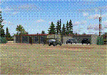
I have made this because I downloaded and tried the Glacier Park photo land-class scenery by Blue Sky Scenery and then rediscovered that the airfield runways are not correctly positioned or aligned in FS9. So I corrected the Ferndale runway and while I was there also added 33 hangars and some parked planes. Of course, as all I know about the hangars is the colour of the roof this isn't up to total realism. It is, however, better than nothing and as I have a large stock of hangars from other sceneries not much effort was involved.
Ferndale is an "airpark" type of airfield where folks build their houses and hangers around the field, plus it also has a bunch of hangars; it is the "bunch" that I have replicated, as I have no idea at all what the houses look like. The field is 20 miles southeast of Glacier Park International at 3,060 feet ASL and around 55 miles south of the Canadian border. There are no large towns close by; the nearest would be Missoula, which is some 70 miles further south.
| Filename: | Ferndale_53U_in_Montana_US.zip |
| License: | Freeware, limited distribution |
| Added: | 29th May 2010, 17:54:14 |
| Downloads: | 291 |
| Author: | Roger Wensley |
| Size: | 2.26 MB |
| Category: Flight Simulator 2004 - Scenery | |
| Pontiac Airpark CPC7 in Quebec Canada |
|
Images related to this file:
File Description:
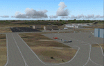
Pontiac Airpark is in Quebec on the north bank of the Ottawa River, some 20 miles northwest of Ottawa in Canada. It is a new airfield and in fact is still under construction, though the east-west runway has been in use since late last year. This east-west runway is 3,400 feet long and gravel, though it will later be lighted, and then asphalted. The second runway will be just under 2,000 feet and unlighted gravel, and at its southern end there are docks for float planes. The float base is already in use; CPC7 is the ICAO code for the float base. There are lots for sale, and the idea is to build your house right on the airfield so there is no driving necessary between house and plane, thus leaving more time for what is important. There will be updates as things progress.
| Filename: | Pontiac_Airpark_CPC7_in_Quebec_Canada.zip |
| License: | Freeware, limited distribution |
| Added: | 1st May 2010, 00:33:40 |
| Downloads: | 339 |
| Author: | Roger Wensley |
| Size: | 7.06 MB |
| Category: Flight Simulator 2004 - Scenery | |
| "Sky King Flying Crown" Version 2 |
|
Images related to this file:
File Description:
Updated version of Bill Lyon's Sky King FS2002 scenery.
| Filename: | Sky_King_Flying_Crown_Version_2.zip |
| License: | Freeware |
| Added: | 1st May 2010, 05:37:45 |
| Downloads: | 397 |
| Author: | Ed Moore and Paul Young |
| Size: | 3.57 MB |
| Category: Flight Simulator 2004 - Scenery | |
| Paugan & Mercier Dams on the Gatineau River in Quebec Canada |
|
Images related to this file:
File Description:
This will not work without Ultimate Terrain, as the rivers and lakes just won't be there. The Paugan and Mercier Dams are on the Gatineau River in Quebec, north of Ottawa. Both of them are for power generation, rather than water conservation; the Paugan power generation building sits at the bottom of the sluiceway below the dam and appears far larger than the dam itself; there is a separate overflow sluice system nearby. The Paugan Dam is around 30 miles north up the river from Ottawa and the Mercier a further 70 miles. The Mercier holds back a huge and irregularly shaped volume of water known as the Reservoir Baskatong, with numerous branching arms and islands, and you will recognise where the dam must be long before you see it.
| Filename: | Paugan__Mercier_Dams_on_the_Gatineau_River_in_Queb.zip |
| License: | Freeware, limited distribution |
| Added: | 3rd May 2010, 00:11:21 |
| Downloads: | 273 |
| Author: | Roger Wensley |
| Size: | 421.81 KB |
| Category: Flight Simulator 2004 - Scenery | |
| KFFC, Peachtree City, Ga |
|
Images related to this file:
File Description:
Re-upload. KFFC, Peachtree City, Ga
Simple EZ scenery addon to liven
up the airport. Based on Tommy
Harris' AFCAD file included.
jimmy R martin
| Filename: | KFFC_Peachtree_City_Ga.zip |
| License: | Freeware |
| Added: | 21st May 2010, 02:52:58 |
| Downloads: | 557 |
| Author: | jimmy R martin, T Harris |
| Size: | 354.74 KB |
| Category: Flight Simulator 2004 - Scenery | |
| San Luis Valley Regl - KALS |
|
Images related to this file:
File Description:
FS2004 Scenery - San Luis Valley Regional/Bergman Field Airport serves Alamosa and Alamosa County and is owned by the City And County of Alamosa, Colorado, USA. The airport has more than one runway. The longest is a paved runway extending 8800 feet. The facility is at an elevation of 7535 feet at a distance of about 2 miles from Alamosa. The Airport (IATA: ALS, ICAO: KALS), also known as Bergman Field, is a public airport used for general aviation, but is also served by one commercial airline. Created with EZ Scenery. EZ Scenery libraries required. Scenery created over USA Roads. By John B. Loney, Jr.
| Filename: | San_Luis_Valley_Regl__KALS.zip |
| License: | Freeware, limited distribution |
| Added: | 23rd May 2010, 01:31:13 |
| Downloads: | 1,032 |
| Author: | John B. Loney, Jr. |
| Size: | 669.56 KB |
| Category: Flight Simulator 2004 - Scenery | |
| KELM - Elmira Corning Regional |
|
Images related to this file:
File Description:
FS2004 Scenery-Elmira/corning Regional Airport serves Elmira and Chemung County and is owned by the County Of Chemung. The airport has more than one runway. The longest is a paved runway extending 7000 feet. The facility is at an elevation of 955 feet at a distance of about 6 miles from Elmira. This scenery has dynamic vehicles and humans, so watch out for ground traffic and pedestrians. Lago's FES is a must for the dynamic scenery. Also created with Rwy12 and FSDS2. Requires Nova, NovaGold, NovaSim and ASDv2.1 textures. AFCAD2 and Traffic Tools files included. By John B. Loney, Jr.
| Filename: | KELM__Elmira_Corning_Regional.zip |
| License: | Freeware, limited distribution |
| Added: | 17th May 2010, 22:03:14 |
| Downloads: | 1,169 |
| Author: | John B. Loney, Jr. |
| Size: | 928.37 KB |
| Category: Flight Simulator 2004 - Scenery | |
| Princeton 2005 |
|
Images related to this file:
File Description:
FS2004 Scenery-A completely reworked Princeton Airport with FSDS2, Rwy12 and Lago's FSE. Princeton Airport(39N) serves Princeton/Rocky Hill and Somerset County NJ and is owned by Princeton Aero Corp. The paved runway extends for 3099 feet. The facility is at an elevation of 125 feet at a distance of about 3 miles from Princeton/Rocky Hill/. Requires AFCAD2, Traffic Tools v2.0, and Nova and Nova Gold textures. Rwy12 and FSE recommended for full effect. By John B. Loney, Jr
| Filename: | Princeton_2005.zip |
| License: | Freeware, limited distribution |
| Added: | 17th May 2010, 22:04:49 |
| Downloads: | 902 |
| Author: | John B. Loney, Jr. |
| Size: | 1.38 MB |
| Category: Flight Simulator 2004 - Scenery | |
| Memphis Municipal Airport 1958 |
|
Images related to this file:
File Description:
Memphis Municipal Airport circa 1958. To be used with ArkLaMiss scenery or may be used stand alone. Designed with Sketchup & EZ Scenery.
| Filename: | Memphis_Municipal_Airport_1958.zip |
| License: | Freeware |
| Added: | 20th May 2010, 09:12:02 |
| Downloads: | 133 |
| Author: | Paul Young, Tom Gibson |
| Size: | 3.12 MB |
| Category: Flight Simulator 2004 - Scenery | |
| Birmingham International Airport, UK (EGBB) v1.2 Update |
|
File Description:
Re-upload. This is an update of my FS2004 scenery of EGBB. DME positions are now accurately positioned and runways now have TDZ lighting.
| Filename: | Birmingham_International_Airport_UK_EGBB_v12_Updat.zip |
| License: | Freeware, limited distribution |
| Added: | 20th May 2010, 09:46:19 |
| Downloads: | 5,801 |
| Author: | Phil Reynolds |
| Size: | 16.31 KB |
© 2001-2026 AVSIM Online
All Rights Reserved
Privacy Policy |