
Where Flight Simulation Enthusiasts Gather from Around the World!
AVSIM Library - Search Results

| Category: Flight Simulator 2004 - Scenery | |
| FS2004-Version Radebeul - Update for FS2002 |

|
File Description:
FS2004 Scenery Radebeul - Update for FS2002-Version
| Filename: | FS2004Version_Radebeul__Update_for_FS2002.zip |
| License: | Freeware |
| Added: | 20th May 2010, 23:32:53 |
| Downloads: | 194 |
| Author: | Lutz Fischer |
| Size: | 475.22 KB |
| Category: Flight Simulator 2004 - Scenery | |
| Emergency Services Mission 2010-004 |
|
Images related to this file:
File Description:
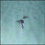
This is a series of missions called Emergency Services. All mission are flown using the Bell 206B JetRanger Helicopter. You may be flying for Fire Rescue, Medical Rescue or for the Police. In this mission you will be flying for Fire Rescue out of Half Moon Bay Airport in Half Moon Bay, CA. Your incident number is 2010-004
| Filename: | Emergency_Services_Mission_2010004.zip |
| License: | Freeware |
| Added: | 13th May 2010, 03:13:52 |
| Downloads: | 251 |
| Author: | David J Crandall |
| Size: | 3.78 MB |
| Category: Flight Simulator 2004 - Scenery | |
| Working TACAN Beacons in the UK |
|
Images related to this file:
File Description:

Working TACAN Beacons in the UK: In real-life TACAN beacons require a TACAN receiver to receive the course (OBS) information of the beacon. With a civil VOR/DME receiver you only receive the distance (DME) to the beacon. The problem in FS is that there are no dedicated TACAN gauges, so it's not possible to perform TACAN approaches, because this requires course information of the beacon. To overcome this problem i've modified the TACAN beacons in the UK so you can fully use them with civil receivers. And so are able to fly TACAN approaches. For charts how to fly the TACAN approaches see (procedure section) http://www.cenor.org/ (reupload) by Marcel Ritzema
| Filename: | Working_TACAN_Beacons_in_the_UK.zip |
| License: | Freeware, limited distribution |
| Added: | 13th May 2010, 21:06:04 |
| Downloads: | 1,020 |
| Author: | Marcel Ritzema |
| Size: | 492.34 KB |
| Category: Flight Simulator 2004 - Scenery | |
| City Federal Building, Birmingham, Alabama |
|
File Description:
Re-upload. Adds the City Federal Building, once the South's tallest to Flight Simulator 2004. It works with Ultimate Terrain, my other sceneries, and the Toni Hitulten Birmingham, Alabama scenery.
| Filename: | City_Federal_Building_Birmingham_Alabama.zip |
| License: | Freeware |
| Added: | 13th May 2010, 21:55:28 |
| Downloads: | 959 |
| Author: | Brittany and Argus Sventon |
| Size: | 79.34 KB |
| Category: Flight Simulator 2004 - Scenery | |
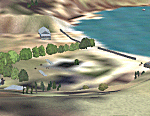
| Factory Field CF40 in Quebec Canada |
|
Images related to this file:
File Description:
Factory Field (my name for it) is in Quebec on highway 321 a few miles north of St Andre Avellin, and 40 miles ENE of Ottawa. The runway is 3,500 feet long and asphalt and went out of regular use in the early 1990's when the airfield was closed. It was sold in 1995 to a company (ELP) that has built up a factory for manufacturing and fitting snow ploughs and other pneumatically operated equipment to trucks, and who now use the runway for testing their snow ploughs. In between times, as it is not marked closed with an "X", it is also occasionally used by customers who fly in, usually to get the drivers there to take delivery of completed trucks. The surface is good and there are no obstructions but also no markings, though with 3,500 feet of 100 feet wide asphalt there is plenty of space and it doesn't much matter.
| Filename: | Factory_Field_CF40_in_Quebec_Canada.zip |
| License: | Freeware, limited distribution |
| Added: | 13th May 2010, 22:11:41 |
| Downloads: | 347 |
| Author: | Roger Wensley |
| Size: | 1.27 MB |
| Category: Flight Simulator 2004 - Scenery | |
| Hauraki Gulf, v6 |
|
Images related to this file:
File Description:
This replaces all my previous Pakatoa Island and Hauraki Gulf sceneries. You must have Christian Stock's NZ mesh in the form of "Mountains of New Zealand" and topo in the form of "Lakes and Rivers of New Zealand" (payware).
New additions...PAKIHI ISLAND: Small jetty and nearby buildings. TAKANGAROA ISLAND: House on Island. House & Jetty island north of Takangaroa Island. MOTUREKAREKA ISLAND: Wreck of the Rewa. PONUI ISLAND: Chamberlain's Bay Airstrip. Chamberlain's Donkey Farm. Third Bay Airstrip. Motunau Bay Jetty. KARAMURAMU ISLAND: Jetty and quarry. ROTOROA ISLAND: Rotoroa Jetty. MOTUIHE ISLAND: Motuihe Wharf.
| Filename: | Hauraki_Gulf_v6.zip |
| License: | Freeware |
| Added: | 17th April 2010, 16:10:12 |
| Downloads: | 218 |
| Author: | Godfrey Tier |
| Size: | 6.61 MB |
| Category: Flight Simulator 2004 - Scenery | |
| Helmericks 22AK on the North Slope, Alaska |
|
Images related to this file:
File Description:
Helmericks is on the northern coast of Alaska, 150 miles east of Barrow and 50 miles west of Prudhoe Bay. It is on the shore of Colville Island in the delta of the Colville River, and hasn't changed much from when Harmon Helmericks set up house there in the late 1950's. He lived there with his wife and two sons guiding hunting trips and running a fishing operation, and then in 1966 he was involved in the first north slope exploratory oil well drilling operation by Sinclair Oil, which was to lead to the opening up of the north slope in the 1970's. Read "The last of the Bush Pilots" if you want to know more about it. The dirt runway is around 2,400 feet long (long enough for the Wien DC3 to get in with supplies) and the house is still there along with storage sheds. To the southwest are the other houses (three of them) which make up the rest of Colville Village. If you want to have the frozen lakes and river and sea then look for my recent post which will freeze them until you get bored and want to put your floats back on.
| Filename: | Helmericks_22AK_on_the_North_Slope_Alaska.zip |
| License: | Freeware, limited distribution |
| Added: | 17th April 2010, 16:21:03 |
| Downloads: | 392 |
| Author: | Roger Wensley |
| Size: | 1.22 MB |
| Category: Flight Simulator 2004 - Scenery | |
| Belize, Lamanai Airfield |
|
Images related to this file:
File Description:
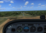
Lamanai is Belize's newest and most controversial airfield. It was built to facilitate access to the Lamanai archaeological sites (the limited area you see in your GPS while flying over).
| Filename: | Belize_Lamanai_Airfield.zip |
| License: | Freeware, limited distribution |
| Added: | 4th May 2010, 09:12:40 |
| Downloads: | 188 |
| Author: | Alf B. Meier |
| Size: | 204.45 KB |
| Category: Flight Simulator 2004 - Scenery | |
| Wadi Seidna, Sudanese Air base |
|
Images related to this file:
File Description:
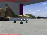
It's a fictionally scenery based on Google earth picture, about a military base in Sudan, called Wadi Seidna, home (maybe) of Sudanese Air force MIG29 FULCRUM squadron.
You required some libraries (from MAIW and EZ-Scenery) for complete functionality.
| Filename: | Wadi_Seidna_Sudanese_Air_base.zip |
| License: | Freeware |
| Added: | 4th May 2010, 09:14:52 |
| Downloads: | 536 |
| Author: | Luciano Franchini |
| Size: | 166.38 KB |
| Category: Flight Simulator 2004 - Scenery | |
| Terrain Mesh (LOD08) for Nunavut, Canada (File 4 of 4) |
|
File Description:
Re-uploaded file. FS2002 and FS2004. The files in this package contain a new 153m (LOD08) terrain mesh for Nunavut, Canada ( and northern part of Northwest Territories) to use with FS2002 and FS2004. The source data is GeoBase (CDED-1 : 250 000). All data were compiled and edited in MicroDEM 7.01 alpha and resampled to LOD08 (Level of Details), or 152.88 meters horizontal resolution, with the Microsoft Terrain Software Developer's Kit (SDK) utilities.
(Nunavut8a.zip, Nunavut8b.zip Nunavut8c.zip Nunavut8d.zip - 4 Parts).
| Filename: | Terrain_Mesh_LOD08_for_Nunavut_Canada_File_4_of_4.zip |
| License: | Freeware, limited distribution |
| Added: | 5th May 2010, 09:14:41 |
| Downloads: | 4,253 |
| Author: | Gilles Gauthier |
| Size: | 30.7 MB |
© 2001-2026 AVSIM Online
All Rights Reserved
Privacy Policy |