|
AVSIM Library
|
|
Login | Register | About logging in and out
|
|
|
|
|
|
|
|
|
|
|
|
|
|
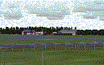
ETND - Diepholz AB - Bremen, Germany
|


|
Images related to this file:
|
File Description:
Diepholz Airbase is the home of Luftwaffenversorgungsregiment 2 of the German Airforce and although the home of Flugplatz Diepholz-Duemmerland southwest of Bremen.
|
| Filename: |
diepholz_ab_etnd.zip |
| License: |
Freeware |
| Added: |
10th September 2015, 17:25:50 |
| Downloads: |
634 |
| Author: |
David Kolas |
| Size: |
2981kb |
|
|
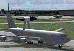
ETNG Geilenkirchen
|
|
Images related to this file:
|
File Description:
A simple representation of Geilenkirchen NATO airbase, including many custom buildings, which are not 100% accurate but however look like the originals. Geilenkirchen was opened as an RAF base in the early 50's . Today the airbase is used by NATO AWACS aircraft.
|
| Filename: |
etng_geilenkirchen.zip |
| License: |
Freeware |
| Added: |
13th March 2010, 12:47:35 |
| Downloads: |
1658 |
| Author: |
Nils Lips |
| Size: |
2524kb |
|
|
ETNL Rostock-Laage
|
|
File Description:
This is a freeware scenery of Rostock-Laage Airport (ETNL), located in north-east Germany. It contains the new and old passenger-terminal and also some objects of the military-used part.
| Filename: |
etnl_rostock-laage_2.01.zip |
| License: |
Freeware, limited distribution |
| Added: |
19th February 2006, 20:43:01 |
| Downloads: |
7273 |
| Author: |
Bernd Roth |
| Size: |
3138kb |
|
|
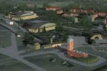
ETNU - Neubrandenburg Airport -Trollenhagen, Germany
|
|
Images related to this file:
|
File Description:
Neubrandenburg-Trollenhagen 2012. Neubrandenburg Airport (ETNU) is a public airport and military airbase located in Trollenhagen, 6 km northeast of Neubrandenburg in Mecklenburg-Vorpommern, Germany. By Frithjof Koch, Volker Low, Rainer Mehlin, Henry Baumann.
|
| Filename: |
etnu_2012.zip |
| License: |
Freeware |
| Added: |
29th April 2013, 17:12:42 |
| Downloads: |
1529 |
| Author: |
Frithjof Koch, Volker Loew, Rainer Mehlin, Henry Baumann |
| Size: |
31777kb |
|
|
ETNW 2004 Wunstorf V2.0
|
|
File Description:
ETNW - Wunstorf , GAF, Germany
VERSION 2.0 - Freeware.
Wunstorf (ETNW) is located nearly Hannover in Lower Saxonia, Germany.
Scenery have a AFCAD2-File included and change automatically Standard-ETNW in FS2004. This Scenery is FS2004 use only.
| Filename: |
etnw2004.zip |
| License: |
Freeware |
| Added: |
13th April 2004, 03:18:13 |
| Downloads: |
4453 |
| Author: |
Gustav Ernst |
| Size: |
1044kb |
|
|
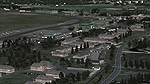
ETUO - RAF Gutersloh AB
|
|
Images related to this file:
|
File Description:
FS 2004 scenery - RAF Gutersloh AB (ICAO: ETUO)
The scenery represents the former airbase of RAF Gutersloh, one of the most populated military bases in West Germany during the Cold War, due to its location near the former East/West border. This scenery reflects the era at the end of the 1980s/beginning of the 90s, when the Harrier GR3 was in operation there, along with Chinook helicopters.
The airfield was built in 1935 and was used by the German Air Force during WW2, flying the Junkers JU-86 and Heinkel H-111. The first British squadrons were stationed there from 1947, with Mosquitos, Vampires and then Canberras.
The first Harrier arrived at Gutersloh in January 1977 and 3 and 4 Squadrons became resident until their farewell in 1993, after the cold war had ended. The airfield is currently used by the British army, but they will leave in 2014 to relinquish the area to the Government of Gutersloh for civil usage.
High detailed scenery by Manfred Schyma and Pete Beeby, supported by the Airfield Construction Group.
|
| Filename: |
raf_gutersloh_fs9_1.zip |
| License: |
Freeware |
| Added: |
10th October 2013, 20:30:01 |
| Downloads: |
1859 |
| Author: |
Manfred Schyma / Pete Beeby |
| Size: |
182180kb |
|
|
Euroairport Basel Mulhouse Freiburg
|
|
File Description:
The Euroairport Basel Mulhouse Freiburg LFSB, Pre-Release
Created 18.04.2004, Tested with Win XP on F2004.
This is a Pre-Release of the EAP LFSB because of many requests.
Still a lot of work has to be done!
| Filename: |
eap20040418.zip |
| License: |
Freeware |
| Added: |
19th April 2004, 04:02:59 |
| Downloads: |
8708 |
| Author: |
Joerg Unglaub |
| Size: |
12176kb |
|
|
Europe Soaring Scenery
|
|
File Description:
FS2002/2004 Europe Soaring Scenery
This file adds some thermals to default Microsoft scenery for some main cities region:
1.Madrid City,Spain - Barajas Airport(LEMD).
2.Oslo City,Norway - Gardermoen Airport(ENGM).
3.Helsinki City - Malmi Airport(EFHF).
4.Copenhagen,Denmark - Kastrup Airport(EKCH).
5.Dublin City,Ireland - Dublin Intl. Airport(EIDW).
6.Glasgow City,Scotland - Glasgow Airport(EGPF).
7.Brussels City - Belgium - Brussels National Airport(EBBR).
8.Moscow City - Sheremetyevo Airport(UUEE).
9.Amsterdam City - Schipol Airport(EHAM).
It is freeware.
By Francisco Vargas.
E-mail:cmtvargas@superonda.com.br
| Filename: |
soeurope.zip |
| License: |
Freeware |
| Added: |
9th November 2005, 10:46:31 |
| Downloads: |
10304 |
| Author: |
Francisco Augusto Vargas Carneiro |
| Size: |
1672kb |
|
|
Europe SRTM mesh part 01: LOD7 buffer mesh
|
|
File Description:
Europe SRTM LOD9 mesh part 1 of 13: This is a LOD7 mesh covering the whole Europe from 35�N to 60�N and 12�W to 30�E, to be used as a buffer mesh in conjection with the LOD9 mesh. This Europe SRTM project was optimized for the lowest HDD space use: Each part macthing exactly the boundaries of its neighbors, you'll have a complete corevage of Europe without gap or overlapping scenery. Based on SRTM Data v1 and v2 (3 arcsec, 90m) and sampled to LOD7 resolution (300m). Each SRTM tile was carefully checked and repaired with Blackart v4.02: water areas are now flattened (lighter mesh), and SRTM voids were treated taking advantage of Blackart's sophisticated interpolation algorithm. When required, biggest voids were patched with oversampled SRTM 30 arcsec data and/or manual input.
| Filename: |
eur_srtm_01.zip |
| License: |
Freeware, limited distribution |
| Added: |
19th October 2005, 16:11:05 |
| Downloads: |
18988 |
| Author: |
Yohann Baptiste |
| Size: |
51487kb |
|
|
Europe SRTM mesh Part 02: UK & Ireland
|
|
File Description:
Europe SRTM LOD9 mesh part 2 of 13: Covers all of UK & Ireland except the Shetlands, and a tiny part of France (from Calais to Abbeville).
This Europe SRTM project was optimized for the lowest HDD space use: Each part macthing exactly the boundaries of its neighbors, you'll have a complete corevage of Europe without gap or overlapping scenery. Based on SRTM Data v1 and v2 (3 arcsec, 90m) and sampled to LOD9 resolution (90m). Each SRTM tile was carefully checked and repaired with Blackart v4.02: water areas are now flattened (lighter mesh), and SRTM voids were treated taking advantage of Blackart's sophisticated interpolation algorithm. When required, biggest voids were patched with oversampled SRTM 30 arcsec data and/or manual input.
| Filename: |
eur_srtm_02.zip |
| License: |
Freeware, limited distribution |
| Added: |
19th October 2005, 16:11:56 |
| Downloads: |
17870 |
| Author: |
Yohann Baptiste |
| Size: |
37033kb |
|
  |
