|
AVSIM Library
|
|
Login | Register | About logging in and out
|
|
|
|
|
|
|
|
|
|
|
|
|
|
Europe SRTM mesh part 05: Poland
|


|
File Description:
Europe SRTM LOD9 mesh part 5 of 13: Covers all parts of Poland north of 50'N. This Europe SRTM project was optimized for the lowest HDD space use: Each part matching exactly the boundaries of its neighbors, you'll have a complete coverage of Europe without gap or overlapping scenery.
Based on SRTM Data v1 and v2 (3 arcsec, 90m) and sampled to LOD9 resolution (90m). Each SRTM tile was carefully checked and repaired with Blackart v4.02: water areas are now flattened (lighter mesh), and SRTM voids were treated taking advantage of Blackart's sophisticated interpolation algorithm. When required, biggest voids were patched with oversampled SRTM 30 arcsec data and/or manual input.
| Filename: |
eur_srtm_05.zip |
| License: |
Freeware, limited distribution |
| Added: |
23rd December 2009, 10:34:50 |
| Downloads: |
17114 |
| Author: |
Yohann Baptiste |
| Size: |
35847kb |
|
|
Europe SRTM mesh part 10: Lower Danube
|
|
File Description:
Europe SRTM LOD9 mesh part 10 of 13: Covers a wide area centered over the Danube valley from Novi Sad to the Black Sea (42�N-46�N, 19�E-30�E). Includes Balkans & Transylvanian moutain ranges, and parts of the following countries: Romania, Bulgaria, Serbia and Albania.
This Europe SRTM project was optimized for the lowest HDD space use: Each part macthing exactly the boundaries of its neighbors, you'll have a complete corevage of Europe without gap or overlapping scenery. Based on SRTM Data v1 and v2 (3 arcsec, 90m) and sampled to LOD9 resolution (76m). Each SRTM tile was carefully checked and repaired with Blackart v4.02: water areas are now flattened (lighter mesh), and SRTM voids were treated taking advantage of Blackart's sophisticated interpolation algorithm. When required, biggest voids were patched with oversampled SRTM 30 arcsec data and/or manual input.
| Filename: |
eur_srtm_10.zip |
| License: |
Freeware, limited distribution |
| Added: |
19th October 2005, 17:55:10 |
| Downloads: |
11681 |
| Author: |
Yohann Baptiste |
| Size: |
40076kb |
|
|
Europe SRTM mesh Part 11: Southern Italy
|
|
File Description:
Europe SRTM LOD9 mesh part 11 of 13: Covers southern Italy, Sardinia, Corsica and parts of Croatia and Bosnia.
This Europe SRTM project was optimized for the lowest HDD space use: Each part macthing exactly the boundaries of its neighbors, you'll have a complete corevage of Europe without gap or overlapping scenery. Based on SRTM Data v1 and v2 (3 arcsec, 90m) and sampled to LOD9 resolution (76m). Each SRTM tile was carefully checked and repaired with Blackart v4.02: water areas are now flattened (lighter mesh), and SRTM voids were treated taking advantage of Blackart's sophisticated interpolation algorithm. When required, biggest voids were patched with oversampled SRTM 30 arcsec data and/or manual input.
| Filename: |
eur_srtm_11.zip |
| License: |
Freeware, limited distribution |
| Added: |
20th October 2005, 11:17:43 |
| Downloads: |
14164 |
| Author: |
Yohann Baptiste |
| Size: |
28534kb |
|
|
Europe SRTM mesh Part 13: Western Spain & Portugal
|
|
File Description:
Europe SRTM LOD9 mesh part 13 of 13: Covers Spain west of 4.5�W and Portugal.
This Europe SRTM project was optimized for the lowest HDD space use: Each part macthing exactly the boundaries of its neighbors, you'll have a complete corevage of Europe without gap or overlapping scenery. Based on SRTM Data v1 and v2 (3 arcsec, 90m) and sampled to LOD9 resolution (76m). Each SRTM tile was carefully checked and repaired with Blackart v4.02: water areas are now flattened (lighter mesh), and SRTM voids were treated taking advantage of Blackart's sophisticated interpolation algorithm. When required, biggest voids were patched with oversampled SRTM 30 arcsec data and/or manual input.
| Filename: |
eur_srtm_13.zip |
| License: |
Freeware, limited distribution |
| Added: |
20th October 2005, 11:22:13 |
| Downloads: |
15442 |
| Author: |
Yohann Baptiste |
| Size: |
35039kb |
|
|
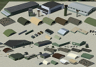
European Military Object Library
|
|
Images related to this file:
|
File Description:
This library is derived using models from some of my already released custom sceneries as well as numerous new objects. Most of the objects are found at military bases and share a common green/brown pallete that is prevalent in many Western European Countries. The object of this library is to allow users to quickly set up a bare minimum scenery for themselves or add more detail to any existing scenery. Library includes over 120 objects including Barracks/Dormitory Buildings, Utility Buildings, Unimog-type vehicles, Avionics Objects, Shelters, Hangars, and more. All objects are XML based and can be placed with most scenery programs.
|
| Filename: |
euromil_js.zip |
| License: |
Freeware, limited distribution |
| Added: |
4th May 2014, 19:27:27 |
| Downloads: |
1061 |
| Author: |
John Stinstrom |
| Size: |
6246kb |
|
|
Even More Private Strips
|
|
File Description:
Even more 'Private Strips' from around England and Wales. When combined with my previous "Private Strips Revisited" upload these will give a total of nearly 500 little airfields, which have been predominantly created to provide a source for GA and microlight ai traffic flights, without having to clutter up the more major airfields. All airfields have parking for (usually) two aircraft and associated taxiways to facilitate their coming and going.
Please note :- these sceneries have been designed for use in FS2004 with the original UK VFR Photographic scenery and mesh. They rely for details on the "usual" collections of library objects, specifically EZ-Scenery, UKVFR and Rwy12 libraries. Whilst other configurations will probably work, to a degree, you'll have to try them and see if they suit you. See the enclosed ReadMe for further details.
| Filename: |
more_private_strips.zip |
| License: |
Freeware |
| Added: |
3rd August 2021, 00:59:25 |
| Downloads: |
91 |
| Author: |
Chris Eve |
| Size: |
538kb |
|
|
Evergreen Lake, Colorado (just west of Denver)
|
|
File Description:
Evergreen, CO is a beautiful little mountain community in the Rocky Mountain foothills (just west of Denver). This scenery and landclass adds the lake in Evergreen, the golf course and also adds the landclass for Kittredge and Morrison (nearby towns). Take a look at the pictures (the town doesn't even exist in the default FS2004).
| Filename: |
evergreen.zip |
| License: |
Freeware |
| Added: |
24th August 2003, 02:56:10 |
| Downloads: |
2255 |
| Author: |
Chris Klein |
| Size: |
212kb |
|
|
Evora Aerodrome, Portugal (LPEV)
|
|
File Description:
Scenery for LPEV Evora, Portugal, home of the Portugal Air Show. Replace the location of the default runway with realistic buildings, taxiways, aprons, parking spots, runway and taxiway lights and the new NDB. New flatten and exclude files. Animation in Agroar Hangar doors using NAV2 112.00 frequency.
| Filename: |
lpev_evora.zip |
| License: |
Freeware |
| Added: |
26th May 2006, 01:04:01 |
| Downloads: |
3452 |
| Author: |
Jos� Maia |
| Size: |
2863kb |
|
|
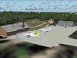
EVVA Ventspils International, Latvia
|
|
Images related to this file:
|
File Description:
Googly scenery for Ventspils International - Latvia's third largest commercial airport
(try not to laugh!) although no facilities other than a runway are provided in Flight
Simulator 2004. These scenery files add taxiways, aprons, buildings and other airport
features, so that you and your "AI" traffic can land, taxi, park and take off in a
realistic manner.
The airport serves the city of Ventspils in northwest Latvia and opened as recently
as 1975. Owing to changes in the political situation, operations ceased in 1983 but
it re-opened in 2000. At present, it is unclear which operators serve the airport
- Air Baltic is the claimed contender but there is no evidence in their advertised
schedules. It is believed that occasional flights are operated to St Petersburg and
Moscow by Russian operators but information is hard to come by. Nevertheless, the
airport's own web site (http://www.airport.ventspils.lv/) has figures showing the
increasing numbers of passengers passing through the airport, so something must
call here! The airport also sees a respectable amount of General Aviation activity
and AVGAS has recently been made available.
The scenery does not purport to be ultra-accurate. Based on high-detail satellite
imagery from Google Earth, the layout is proportionally correct but the added
airport features, such as buildings, are built from default Microsoft objects
and add-on libraries so will not look like the real thing. [File re-uploaded at request of AVSIM]
|
| Filename: |
evva.zip |
| License: |
Freeware |
| Added: |
15th June 2010, 00:59:50 |
| Downloads: |
1570 |
| Author: |
John Hinson |
| Size: |
90kb |
|
|
Exclude to remove some incorrectly placed bridges in Egypt
|
|
Images related to this file:
File Description:
A Desert Flower Exclude. While flying around Egypt you may have encountered another error which shipped with FS2004 - a flower like arrangement of bridges (see screenshots) which are totally out of place. This file includes provides a VTPX exclude bgl which removes them. Please unzip to a temporary folder and follow the very simple installation instructions. Compiled for your flying enjoyment by David "Opa" Marshall.
| Filename: |
eqypt_bridge_exclude.zip |
| License: |
Freeware |
| Added: |
11th November 2009, 00:27:41 |
| Downloads: |
2043 |
| Author: |
David "Opa" Marshall |
| Size: |
259kb |
|
  |
