|
AVSIM Library
|
|
Login | Register | About logging in and out
|
|
|
|
|
|
|
|
|
|
|
|
|
|
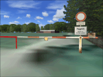
Essex Airstrips nonVFR
|


|
File Description:
This mod removes the autogen scenery from the ESSEX AIRSTRIPS if not using VFR PHOTO SCENERY. These files serve only to compliment Pete Chapman's work, not alter or modify it in any way. It misses the point of Pete's work really as it flattens the runways a bit, but I couldn't find a solution for that... it just allowed me to fly with regular autogen on maximum. Elevations may differ slightly in online multiplayer to those using VFR scenery and the default ESSEX AIRTRIPS...Requires ESSEX AIRSTRIPS by Pete Chapman
| Filename: |
essex_airstrips_nonvfr.zip |
| License: |
Freeware |
| Added: |
10th April 2009, 01:47:18 |
| Downloads: |
144 |
| Author: |
Paul Leaver |
| Size: |
4kb |
|
|
Essex County Airport (KCDW)
|
|
Images related to this file:
File Description:
FS2004 Scenery - Essex County Airport (IATA: CDW, ICAO: KCDW, FAA LID: CDW) is a public airport located two miles (3 km) north of the central business district of Caldwell, a borough of northwestern Essex County in the U.S. state of New Jersey. It is owned by the Essex County Improvement Authority. The airport has two asphalt runways, 4/22 and 10/28. Created by John B. Loney, Jr.
| Filename: |
essex_county_airport_kcdw_fs9.zip |
| License: |
Freeware, limited distribution |
| Added: |
4th April 2012, 03:26:13 |
| Downloads: |
429 |
| Author: |
John B. Loney, Jr. |
| Size: |
20167kb |
|
|
Esslingen-Jaegerhaus glider airfield, Germany
|
|
Images related to this file:
|
File Description:
Grass runway with 0.5m/pixel high-definition background images, surroundings with areal photo textures and landclass, full seasonal textures. Several custom buildings, fences, objects and tons of trees give the closest possible resemblance to it's real-world counterpart northeast of Stuttgart Airport (EDDS).
This airfield is jointly utilized and cared for by the two departments of the Aero-Club Esslingen, the full-scale glider fliers and the RC-model fraction.
|
| Filename: |
jaegerh1.zip |
| License: |
Freeware, limited distribution |
| Added: |
25th April 2010, 20:23:08 |
| Downloads: |
1847 |
| Author: |
Mathias Elsaesser |
| Size: |
12612kb |
|
|
Esta��o Ant�rtica Comandante Ferraz - King George Island - Antarctica
|
|
File Description:
The Antarctica Base Comandante Ferraz belongs to the Brazilian Antarctica Program PROANTAR.
In real life, this base has no runway, just a helipad. We added one to be more confortable for you to visit the base. *****
A Esta��o Ant�rtica Comandante Ferraz pertence ao programa Brasileiro de Pesquisas na Ant�rtica - PROANTAR .
Na realidade n�o existe um aeroporto no local,somente um heliporto, mas adicionamos um para sua comodidade ao visitar a Esta��o.
| Filename: |
eacf.zip |
| License: |
Freeware, limited distribution |
| Added: |
9th February 2007, 17:36:46 |
| Downloads: |
3930 |
| Author: |
Jos� Manuel Santos |
| Size: |
4659kb |
|
|
Estrella Bay, Solomon Islands (AMAC)
|
|
File Description:
The 'less than stable' pilots over at Margarita Air have released another new scenery, this time at their own private airstrip on the Solomon Islands. Estrella Bay contains a small airstrip with maintenance and fuel facilities along with "TJ's Bar and Grille", the home of cold beer and hot women. Visit http://www.margaritaair.com for more information on this loose band of ragtag pilots.
| Filename: |
amac.zip |
| License: |
Freeware |
| Added: |
16th October 2005, 03:42:52 |
| Downloads: |
970 |
| Author: |
Todd Lucas |
| Size: |
2473kb |
|
|
ETAD Spangdahlem AB
|
|
Other files which are related to, or may be required by, this file:
File Description:
Home to the 52nd Fighter Wing. Accurate representation of the USAFE base, created from many photos and an airport diagram. Includes several custom objects created using GMAX. AFCAD and parking included.
| Filename: |
etad.zip |
| License: |
Freeware, limited distribution |
| Added: |
14th November 2005, 01:53:44 |
| Downloads: |
6133 |
| Author: |
Ian McCartney |
| Size: |
1358kb |
|
|
ETAD Spangdahlem AB Fix
|
|
Other files which are related to, or may be required by, this file:
File Description:
Fix for the building crash which is experienced when taxing along the main taxiway between the HAS complex's. Requires ETAD.zip.
| Filename: |
etadfix.zip |
| License: |
Freeware, limited distribution |
| Added: |
16th November 2005, 19:31:56 |
| Downloads: |
4059 |
| Author: |
Ian McCartney |
| Size: |
195kb |
|
|
Etimesgut AB/Ankara(Turkey) Airport (LTAD/ANK) scenery (2016)
|
|
Images related to this file:

|
File Description:
Etimesgut AB/Ankara(Turkey) Airport (LTAD/ANK) scenery (2016) for Flight Simulator 2004 (Fs9). This military airport is in Ankara, the capital of Turkey. Esenboga (LTAC) is very close to the airport. Flight training is given here. The pilot is raised. There are two large and long aprons on either side of the runway. This aprons has a very large number of flight training buildings and hospitals. Bombardier, Gulfstream, Cessna 560XL Excel, Businesss Jet, CL215-Fire fighter, Dash8, Saab-340, CN235, etc. GA airplanes have been configured for parking. Thanks for using. Scenery design by VAPS (vaps.hooxs.com)
|
| Filename: |
ltad_etimesgut2016fs9.zip |
| License: |
Freeware |
| Added: |
14th April 2017, 07:18:47 |
| Downloads: |
905 |
| Author: |
Pilot Hoca (VAPS) |
| Size: |
9088kb |
|
|
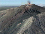
Etna Volcano seasonal effects, Sicily, Italy, Photo Real
|
|
Other files which are related to, or may be required by, this file:
Images related to this file:
|
File Description:
This scenery covers the summit of Etna Volcano with seasonal variation (Winter, Summer, Spring, Fall and night texture).
Use it ONLY in association of Etna photoreal scenery (see AVSIM library - etna_photoreal.zip). NOTE: place Etna_season scenery with higher priority than Etna_photoreal in scenery library (see readme text).
|
| Filename: |
etna_season.zip |
| License: |
Freeware |
| Added: |
1st June 2010, 20:43:12 |
| Downloads: |
9698 |
| Author: |
Fulvio Mazzokan |
| Size: |
37560kb |
|
|
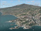
Etna Volcano, Sicily, Italy, Photo Real
|
|
Other files which are related to, or may be required by, this file:
Images related to this file:
|
File Description:
The photoreal scenery covers a greater part of Sicily around the Etna Volcano and Catania city. The Photo Real Scenery is wide for around 2000 squared Kms. Etna volcano, 10,958 ft (3,340 m) high, is placed on the east coast of Sicily (South Italy). It is the highest active volcano in Europe. The airport of Catania fontanarossa (ICAO code LICC) is found inside the scenery.
|
| Filename: |
etna_photoreal.zip |
| License: |
Freeware |
| Added: |
3rd June 2010, 17:35:05 |
| Downloads: |
12552 |
| Author: |
Fulvio Mazzokan |
| Size: |
52908kb |
|
  |
