
Where Flight Simulation Enthusiasts Gather from Around the World!
AVSIM Library - Search Results

| Category: Flight Simulator 2004 - Scenery | |
| Leadville (KLXV), Mt. Elbert, Colorado, Photo-Scenery (FS9 & FSX) |

|
Images related to this file:
File Description:
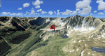
Extends my Aspen scenery to the east and contains more gorgeous Continental Divide area of the Rocky Mountains. Covers Leadville Lake County Airport (KLXV), which is the highest airport in North America (9.927 ft) and Mt. Elbert, which is the highest peak in the Rocky Mountains (14.443 ft). Aircraft performance deteriorates
with altitude, so many companies use the Leadville Airport as a base for high altitude performance testing. This scenery brings you another 3.500 sq km of beautiful Colorado in 4.7m/pix quality.
High resolution versions of this scenery for FS9 and FSX (much sharper, but larger and multiple downloads) are available at www.blueskyscenery.com/GNB_South2West.html . The screenies are taken from the high-res versions, so expect this version to be slightly more blurry. YourDonation@Work: Dedicated to Daniel, Art and Rotui.
| Filename: | Leadville_KLXV_Mt_Elbert_Colorado_PhotoScenery_FS9.zip |
| License: | Freeware |
| Added: | 1st February 2010, 19:06:58 |
| Downloads: | 1,709 |
| Author: | Gottfried Razek - blueskyscenery.com |
| Size: | 94.68 MB |
© 2001-2026 AVSIM Online
All Rights Reserved
Privacy Policy |