
Where Flight Simulation Enthusiasts Gather from Around the World!
AVSIM Library - Search Results

| Category: Flight Simulator 2004 - Scenery | |
| FTTN Am-Timan, Chad |

|
File Description:
Googly scenery for Am-Timan (ICAO: FTTN, ICAO: ANC), also known as Am
Timan, Am Timane, Am Timmane, Umm Timman - take your pick! It is a small
airport serving a small city of the same name in South-Eastern Chad,
almost exactly centred in the continent of Africa.
The airport was upgraded in 1971 by the French Foreign Legion to allow
military transport craft to land, but it still retains a sand/dirt
strip. The airport is served today by a couple of flights a week using
Fokker Fellowship jets of Toumai Air Tchad.
The entire area is very dry and sandy but for some reason it is depicted
in Flight Simulator as green and lush. Microsoft have only provided a runway
at this airport and this scenery seeks to redress the situation so that you
and your "AI" traffic can use the airport realistically.
The scenery does not purport to be ultra-accurate. Based on high quality
satellite imagery from Google Earth, the layout is proportionally correct but the
added airport features, such as buildings, are built from default Microsoft objects
and add-on libraries so will not look exactly like the real thing.
You are not obliged to download and install any additional scenery libraries,
but to enjoy this scenery in its entirety, you may wish to. It will work fine,
with or without.
| Filename: | FTTN_AmTiman_Chad.zip |
| License: | Freeware |
| Added: | 24th December 2008, 13:31:36 |
| Downloads: | 883 |
| Author: | John Hinson |
| Size: | 83.66 KB |
| Category: Flight Simulator 2004 - Scenery | |
| South Farallon Islands |
|
File Description:
These islands were mysteriously absent from the FS2004 default scenery, probably owing to their small size. When I went to look for them I found a small mountain of water instead of the islands.
Most people don't seem to be aware of the Farallon Islands. Located off the coast of California, near San Francisco, they are home to thousands of birds, seals, and some of the largest Great White sharks known to man. All of this is within a very short distance of the city.
Today, it is a wildlife refuge and is off limits to visitation by the general public. Those of you interested in more info might check out "The Devil's Teeth" by Susan Casey.
This island is actually a scenery object. As such it doesn't have a landable surface. Future versions will have a helicopter pad.
| Filename: | South_Farallon_Islands.zip |
| License: | Freeware, limited distribution |
| Added: | 29th October 2005, 05:30:42 |
| Downloads: | 791 |
| Author: | Glen Gordon (Prof K.) |
| Size: | 488.04 KB |
| Category: Flight Simulator 2004 - Scenery | |
| The Greater Toronto Area for Ultimate Terrain 1.2 Part 1 |
|
File Description:
Part 1 of Flight Ontario's scenery for the Greater Toronto Area for Ultimate Terrain. The scenery is bounded by Detroit in the west, Kingston in the east, Huntsville in the north and Buffalo in the south and features: * all-season scenery * custom water textures * completely modelled Toronto Airports...CYTZ (Toronto Island) and CYZD (Downsview-home to Bombardier Aerospace and the Canadair Regional Jet and Dash-8, and the Toronto Aerospace Museum) * Niagara Helicopters CPQ3 (NEW) *custom autogen for the GTA * Custom landclass for southern Ontario * prominent features around Hamilton include the Burlington Skyway,lift bridge and steel mills * the Welland Canal is featured with lift bridges from Pt Weller to Pt Colborne * the Niagara area includes two hydro generating plants with reservoirs * compatibility with SimFlyers CYYZ.
This scenery is downloadable in two parts and both parts are essential.
| Filename: | The_Greater_Toronto_Area_for_Ultimate_Terrain_12_P.zip |
| License: | Freeware |
| Added: | 31st December 2005, 18:39:52 |
| Downloads: | 13,898 |
| Author: | Jim Kanold - Flight Ontario |
| Size: | 62.05 MB |
| Category: Flight Simulator 2004 - Scenery Design | |
| LOM Library Objects Images - Set 34 - UK VFR Addons - 778 Object Images |
|
File Description:
FS2004 LOM Library Objects Images - Set 34. This archive contains image import files containing thumbnails or image files for use with Library Object Manager (LOM) version 1.0+ program to manage FS2004 library objects and create scenery by ScruffyDuck Software, Jon Masterson. This is multiple image collections of 778 Objects, animals, buildings, housing, industrial, military, people, rail - water - road transport, rural, shops, lighting, vegetation and walls and fences. Requires LOM_100.ZIP, and installation of UKVFR LIBRARY.EXE and import into LOM of all ".BGL" files which are included with UKVFR LIBRARY.EXE. Please see readme documentation for details on licence and installation of UKVFR ADDONS LIBRARY.EXE. UKVFR Addons Website is: http://www.vfraddons.co.uk/ . Also included are complete sets of higher resolution screenshots to upgrade those images imported into LOM. Higher resolution screenshots are suitable for printing an index or contact sheet of images. By Bryan Wallis.
| Filename: | LOM_Library_Objects_Images__Set_34__UK_VFR_Addons_.zip |
| License: | Freeware |
| Added: | 3rd July 2006, 01:07:03 |
| Downloads: | 1,956 |
| Author: | Bryan Wallis |
| Size: | 13.26 MB |
| Category: Civil Flight Simulators - Looking Glass Flight Unlimited 3 | |
| Seattle Expansion Toolkit |
|
File Description:
Conversion of the Seattle Region from .cpd to .bin for FU3
This experimental toolkit is for region builders, its not a new full game !
If you want expand the region with new material to the north and the east then
conversion to .bin is a must.
Do not convert if you don't plan to expand or modify texture of the tiles.
Then the only results are a larger game folder :-(
The quality of the original tiles will not change !
The Seattle region is converted from 10x10 tiles area into a 16x16 tiles area but just 2 new tiles are made north of Coupeville Nolf as sample, so 154 tiles are then still missing and replaced by the blank tile (new full water tile). As elevation the new NASA-SRTM-V2 model is used. Backup your Seattle region before starting the experiment.
| Filename: | Seattle_Expansion_Toolkit.zip |
| License: | Freeware, limited distribution |
| Added: | 17th February 2007, 22:24:07 |
| Downloads: | 121 |
| Author: | Andre Meystre |
| Size: | 41.8 MB |
| Category: Flight Simulator 2004 - Scenery Design | |
| EZ New GOLF FILES |
|
File Description:
Many have seen my golf course at Andrewsfield, England. These libraries enable you to build an 18 hole course, now, and with many added golf objects. I was asked by John B. Loney Jr. (excellent designer) to do a golf course at Oroville, CA. It is called Table Mountain Golf Course. We used course lay-out maps to design the course close as possible to real life including water hazards. One file in this download is an update which is needed; the other two are new. Be sure to have bobslibraries installed as well since I use a couple of objects from my hangar library which is part of bobslibraries. John is close to done with Oroville, CA (KOVE)along with another he is working on. Be sure to grab those when you see them! As always, comments or suggestions are appreciated. Bob
| Filename: | EZ_New__GOLF__FILES.zip |
| License: | Freeware |
| Added: | 18th August 2007, 23:57:50 |
| Downloads: | 719 |
| Author: | Robert Lacy |
| Size: | 1.72 MB |
| Category: Flight Simulator X - Scenery | |
| EGHA Compton Abbas |
|
File Description:
All additional Buildings were placed using default objects.
AI traffic uses default aircraft which was scheduled by hand using the TrafficDatabaseBuilder from the SDK tools provided by FSX Deluxe.
Any additional roads and modified Landclass & water features were created using FSX-KML.
This package adds the apron , Hangars, clubhouse and the fueling station has been moved to the correct spot between the hangars.
Some of the local roads have been added to allow road access to the airfield.
The main wooded areas have been added to the North and south of the airfield and cropland defined surrounding the immediate area although FSX insists on putting trees on some steeper slopes.
I have also included 3 of the villages nearby , Compton Abbas, Ashmore and Fontmell Magna .
It also provides parking spots and ATC interaction along with some AI traffic.
Hope you like it :)
| Filename: | EGHA_Compton_Abbas.zip |
| License: | Freeware, limited distribution |
| Added: | 1st October 2007, 17:08:37 |
| Downloads: | 1,888 |
| Author: | Len Hickman |
| Size: | 17.45 KB |
| Category: Flight Simulator X - Scenery | |
| Bartlett Village Alaska |
|
Images related to this file:
File Description:
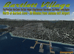
Bartlett Village is just north of Bartlett Cove and created to make your flights to Bartlett Cove more fun. the water runway at Bartlett Cove points north directly at the Village float plane dock. There is also a helipad at the docks along with the Bartlett Village Inn. There are room rentals, cabin rentals, a small store near the docks for food, beverage and fishing supplies. The ACA, Alaska Conservation agency has a work camp on the island and there are two private residences, a light house on the SW end and other candies around the island. Gustavus has several new additions but no changes to the default configuration of the airport. If you fly around on the south west area of the island you may see a whale or two. Come by and visit. Read the readme and enjoy.
created by savageagle.
| Filename: | Bartlett_Village_Alaska.zip |
| License: | Freeware |
| Added: | 7th February 2010, 11:15:59 |
| Downloads: | 1,737 |
| Author: | Tim Durham |
| Size: | 640.35 KB |
| Category: Flight Simulator 2004 - Original Aircraft | |
| Grumman Albatross version 2.1 FDE Landing Lights |
|
File Description:
Grumman HU-16 Albatross 2.1
Greg Pepper, Michael Verlin
revised FDE with landing lights
This package contains revised aircraft.cfg and air files.
I've modified the contact points for the hull and nose gear and retractable landing lights
The contact points for the landing lights were omitted in previous uploads.
The lights are tied to the water rudder (Shift+W). It has been 5 years since version 2.0 was released.
Fortunately, I kept copies of my correspondence with Greg Pepper, which had the information for the missing contact points. They are now included.
My apologies for the error. This should finish matters for version 2.1
Instructions
unzip this file into the Grumman Albatross G64 section of your FS9 Aircraft folder.
overwrite the existing aircraft.cfg and HU16.air files with the files in this package.
Michael Verlin
[email protected]
May 24, 2012
| Filename: | Grumman_Albatross_version_21__FDE_Landing_Lights.zip |
| License: | Freeware, limited distribution |
| Added: | 24th May 2012, 23:01:05 |
| Downloads: | 1,364 |
| Author: | Greg Pepper Michael Verlin |
| Size: | 12.84 KB |
| Category: Flight Simulator X - Utilities | |
| Slewable Control Tower |
|
Images related to this file:
File Description:
WHAT IS IT?
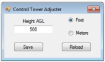
In a nutshell, the stock FSX control tower turned into an airplane with the aerodynamics of a cement brick with highly adjustable landing gear for tower height. No longer does one have to create a multiplayer session to use the stock control tower to do some AI "plane watching". The control tower is fitted with floats so one can slew to a good vantage point at certain airports like Boston Logan, La Guardia or KSFO for instance, floating on water. (Yes, it still "bobs" with waves) This was also done for better stability on uneven ground and the inability to roll around. There are some new features added such as tower flood lighting, a reference switch, and an external program to adjust the tower height (30-1000 ft.) for convenience. ( Not tested at all in P3D )
| Filename: | Slewable_Control_Tower.zip |
| License: | Freeware, limited distribution |
| Added: | 6th September 2013, 15:30:05 |
| Downloads: | 665 |
| Author: | Roman Stoviak |
| Size: | 770.98 KB |


© 2001-2026 AVSIM Online
All Rights Reserved
Privacy Policy |