
Where Flight Simulation Enthusiasts Gather from Around the World!
AVSIM Library - Search Results

| Category: Flight Simulator 2004 - Scenery | |
| Columbia-Willamette Rivers Fix |

|
File Description:
These flattening files lower the elevated water on the Columbia and Willamette rivers in and around Portland, Oregon. On the Columbia River they start east of Astoria, OR (KAST) and proceed east and south through Portland, OR (KPDX) then east to Cascade Locks, OR (KXZK). On the Willamette River they proceed from Portland south to just north of Aurora, OR (KUAO) ending at the collapsed bridge. Several bodies of water next to the Columbia and Willamette rivers have also been flattened. These files work well with FS default scenery and FS Genesis 38m mesh scenery.
| Filename: | ColumbiaWillamette_Rivers_Fix.zip |
| License: | Freeware |
| Added: | 19th April 2004, 22:19:32 |
| Downloads: | 3,062 |
| Author: | Dan Reynolds |
| Size: | 10.4 KB |
| Category: Prepar3D V1-4 - Scenery | |
| Occhito Dam Foggia Italy N41.37.09 E14.58.25 |
|
Images related to this file:
File Description:
Occhito Dam Foggia Italy N41.37.09 E14.58.25 Born from the Fortore River barrage, Occhito dam originates from the second largest artificial water mirror in Italy. The dam rises in the territory of Carlantino, one of the small villages in the province of Foggia on the border with Molise, and was built at the end of the 1950s to meet the water needs of the province.
Important VFR point for approaching airport Foggia Gino Lisa.
Within the downloaded package you will find readme files for scenery installation. Good fly VFR. Pasquale Marrulli.
| Filename: | Occhito_Dam_Foggia_Italy_N413709_E145825.zip |
| License: | Freeware |
| Added: | 14th November 2017, 16:44:52 |
| Downloads: | 301 |
| Author: | Pasquale Marrulli |
| Size: | 1.47 KB |
| Category: Fly! II - TerraScene | |
| Toledo (Ohio Project) TerraScene Project Pack |
|
File Description:
This is a TerraScene 2.1 Project pack for northwestern Ohio. It covers all of global tile 196,160 with Toledo in the center. It extends into Michigan to the north, including the southern part of Detroit. I have included a grass underlay for Detroit Grosse Ile Airport, which sits on Grosse Ile island. This pack includes updated Tiger Census (2000) shapefile data, adding new water areas, new highways, and other details. All scenery data files are included: USGS data, shapefiles, and a complete water mask. Requires TerraScene 2.1 and Fly!II patched to v240.
| Filename: | Toledo_Ohio_Project_TerraScene_Project_Pack.zip |
| License: | Freeware |
| Added: | 11th April 2003, 23:53:22 |
| Downloads: | 189 |
| Author: | Randall Rocke |
| Size: | 48.69 MB |
| Category: Fly! II - TerraScene | |
| Wilmington (Carolinas Project) TerraScene Project Pack |
|
File Description:
This TerraScene 2.1 Project pack covers all of global tile 200,153, with the Atlantic coastline running from Topsoil Beach in the NE past Wilmington and finishing at North Myrtle Beach and Grand Strand. To the north you will find Lake Waccamaw and the Green Swamp. This pack includes updated Tiger Census (2000) shapefile data, adding new water areas, new highways, and other details. All scenery data files are included: USGS data, shapefiles, and a complete custom water mask. Requires TerraScene 2.1 and Fly!II patched to v230 or later.
| Filename: | Wilmington_Carolinas_Project_TerraScene_Project_Pa.zip |
| License: | Freeware |
| Added: | 4th June 2003, 15:45:24 |
| Downloads: | 159 |
| Author: | Randall Rocke |
| Size: | 47.54 MB |
| Category: Fly! II - TerraScene | |
| Charlotte (Carolinas Project) TerraScene Project Pack |
|
File Description:
This TerraScene 2.1 Project pack covers all of global tile 198,154, centering on Charlotte, North Carolina with Lake Wylie and the Rock Hill, SC region to the southwest. It adjoins the Spartanburg global tile to the west and the Winston-Salem tile to the north. This pack includes updated Tiger Census (2000) shapefile data, adding new water areas, new highways, and other details. All scenery data files are included: USGS data, shapefiles, and a complete water mask. Requires TerraScene 2.1 and Fly!II patched to v230 or later.
| Filename: | Charlotte_Carolinas_Project_TerraScene_Project_Pack.zip |
| License: | Freeware |
| Added: | 15th September 2003, 14:23:31 |
| Downloads: | 283 |
| Author: | Randall Rocke |
| Size: | 68.88 MB |
| Category: Fly! II - TerraScene | |
| Johnson City (Carolinas Project) TerraScene Project Pack |
|
Images related to this file:
File Description:
This TerraScene 2.1 Project pack covers all of global tile 197,155, centering on Johnson City and Elizabethton, TN. Following the Cherokee and Pisgah National Forests to the southwest takes you through Greenville, TN into the Smokies. This tile includes Kingsport, TN to the north and Morganton, NC to the east. This pack includes updated Tiger Census (2000) shapefile data, adding new water areas, new highways, and other details. All scenery data files are included: USGS data, shapefiles, and a complete custom water mask. Requires TerraScene 2.1 and Fly!II patched to v230 or later.
| Filename: | Johnson_City_Carolinas_Project_TerraScene_Project_.zip |
| License: | Freeware |
| Added: | 9th May 2010, 00:58:40 |
| Downloads: | 276 |
| Author: | Randall Rocke |
| Size: | 69.35 MB |
| Category: Fly! II - TerraScene | |
| Fontana Lake (Carolinas Project) TerraScene Project Pack |
|
Images related to this file:
File Description:
This TerraScene 2.1 Project pack covers all of global tile 196,154. Adjoining the Knoxville tile, it continues through the Great Smoky Mountains into Cherokee, NC and Fontana Lake. Continuing south, this scenery area extends through portions of western South Carolina and NE Georgia, including Toccoa and Hartwell Lake to the SE. This pack includes updated Tiger Census (2000) shapefile data, adding new water areas, new highways, and other details. All scenery data files are included: USGS data, shapefiles, and a complete custom water mask. Requires TerraScene 2.1 and Fly!II patched to v230 or later.
| Filename: | Fontana_Lake_Carolinas_Project_TerraScene_Project_.zip |
| License: | Freeware |
| Added: | 10th May 2010, 05:20:25 |
| Downloads: | 318 |
| Author: | Randall Rocke |
| Size: | 88.73 MB |
| Category: Civil Flight Simulators - Looking Glass Flight Unlimited 3 | |
| UK_South placeholder texture |
|
Images related to this file:
File Description:
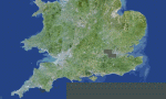
When you try to build the UK_South region for FU3 you will miss the blank water tile and there is a misplaced placeholder ground texture. This zip will correct this with a better ground from a painted map and the earler set of water tiles including the missed level 0 to 3 of them.
Do not apply this zip to other region or to a full UK_South installation then this is just for a starter kit and will overwrite useful tiles when applied to other region or full installation of UK_South.
| Filename: | UK_South_placeholder_texture.zip |
| License: | Freeware, limited distribution |
| Added: | 17th May 2010, 00:04:45 |
| Downloads: | 87 |
| Author: | Andr������© Meystre |
| Size: | 3.89 MB |
| Category: Fly! II - TerraScene | |
| Winston-Salem (Carolinas Project) TerraScene Project Pack |
|
Images related to this file:
File Description:
This TerraScene 2.1 Project pack covers all of global tile 198,155, centering on North Wilkesboro, North Carolina with Jefferson in the NW. To the SW you will find Hickory, while in the NE is Mount Airy. The Winston-Salem metro area is near the eastern border. This pack includes updated Tiger Census (2000) shapefile data, adding new water areas, new highways, and other details. All scenery data files are included: USGS data, shapefiles, and a complete water mask. Requires TerraScene 2.1 and Fly!II patched to v230 or later.
| Filename: | WinstonSalem_Carolinas_Project_TerraScene_Project_.zip |
| License: | Freeware |
| Added: | 21st May 2010, 01:55:45 |
| Downloads: | 15 |
| Author: | Randall Rocke |
| Size: | 62.73 MB |
| Category: Fly! II - TerraScene | |
| Kinston (Carolinas Project) TerraScene Project Pack |
|
File Description:
This TerraScene 2.1 Project pack covers all of global tile 200,154, extending the Atlantic shoreline a short distance north of Wilmington. Inland, it covers the cities of Kinston and Goldsboro, North Carolina. The tile includes Seymour Johnson AFB and numerous small strips along the I-95 and I-40 corridors. This pack includes updated Tiger Census (2000) shapefile data, adding new water areas, new highways, and other details. All scenery data files are included: USGS data, shapefiles, and a complete custom water mask. Requires TerraScene 2.1 and Fly!II patched to v230 or later.
| Filename: | Kinston_Carolinas_Project_TerraScene_Project_Pack.zip |
| License: | Freeware |
| Added: | 13th May 2010, 09:42:13 |
| Downloads: | 169 |
| Author: | Randall Rocke |
| Size: | 78.93 MB |
© 2001-2026 AVSIM Online
All Rights Reserved
Privacy Policy |