
Where Flight Simulation Enthusiasts Gather from Around the World!
AVSIM Library - Search Results

| Category: Flight Simulator 2004 - Scenery | |
| PAEN, PAEX, 3AK4, 30AK, 52AK - Alaska, USA |

|
Images related to this file:
File Description:
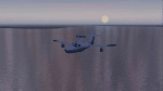
The town of Kenai is on the east coast of Cook Inlet, 60 miles southwest of Anchorage. The airport is in the northern part of the town, with a runway aligned 1-19, 7,550 feet long and 150 feet wide (with an ILS on 19). A second runway is gravel, 2,000 feet long and for winter use by ski planes. There is also a water runway, and all three are aligned the same and called "1 left-19 right" (the main runway) "1 right-19 left" (gravel) and "1 water-19 water". The taxiways are extensive and designed for a far larger traffic than the airport has today, though even now the airport is fairly busy. In FS9 a water runway for AI cannot work with an ATC control tower; the water part of PAEN has therefore been separated into another call sign PAEX which has ONLY the water runway; the tower will therefore direct the plane that makes contact to use the water runway. The PAEN airport runway has taxiway connections at each end and also two intermediates; at the northern end there are in fact two so a total of 5; B, C, D, E, and F; there is an airport diagram included. GA traffic goes to one of two parking aprons, both at the southern end, and at the far southern end there is the hangar for the Civil Air Patrol. The AI includes aircraft from my previous Alaska posts, as Kenai is where I sent them when they departed from, for instance, Palmer. Airlines and cargo companies that operate from and to Kenai are included in the AI: ERA (which has recently changed it's name), Grant Aviation, Air North, Wings of Alaska, North Star Air, and a small local company Air Supply Alaska, along with Fedex, UPS, Everts, and Northern Air Cargo. There is also GA and float AI. Nearby smaller airfields are included, partly because one of them was dramatically misaligned in FS9.
| Filename: | PAEN_PAEX_3AK4_30AK_52AK___Alaska_USA.zip |
| License: | Freeware, limited distribution |
| Added: | 26th December 2015, 15:33:19 |
| Downloads: | 482 |
| Author: | Roger Wensley |
| Size: | 23.08 MB |
| Category: Flight Simulator X - Missions | |
| UtahMysteryLakes.zip |
|
File Description:
Beginner/intermediate helicopter mission. A private helicopter company located at KP39 airport provides tour services. Take passengers on an evening tour of mysterious water phenomena at two lakes in the Utah mountains.
| Filename: | UtahMysteryLakeszip.zip |
| License: | Freeware |
| Added: | 1st April 2022, 23:24:32 |
| Downloads: | 42 |
| Author: | helomissionman |
| Size: | 4.59 MB |
| Category: Flight Simulator 2004 - Scenery | |
| WaterWorks 5.1 |
|
Images related to this file:
File Description:
These textures re-colour and re-glint the FS2004 default waters. They work even better on payware, or other freeware water enviroment addons. They work best on WaterWrkx5. The textures are 32bit.
| Filename: | WaterWorks_51.zip |
| License: | Freeware |
| Added: | 24th December 2011, 09:30:25 |
| Downloads: | 1,212 |
| Author: | Lou McNeil |
| Size: | 28.84 MB |
| Category: Flight Simulator X - Aircraft Repaints, Textures and Modifications | |
| Turbo Beaver Mk3 Emerald livery |
|
File Description:
This is A repaint of the incredibly beautiful Turbo-Beaver for FSX by Premier Aircraft Design.
Some minor tweaks have been done to the water handling, and a new interior was added.
| Filename: | Turbo_Beaver_Mk3_Emerald_livery.zip |
| License: | Freeware |
| Added: | 26th April 2007, 23:35:43 |
| Downloads: | 454 |
| Author: | Jurgen-Maarten Steffers |
| Size: | 8.12 MB |
| Category: Flight Simulator 2004 - Scenery | |
| Turkey Mesh SRTM V2, Part II |
|
Images related to this file:
File Description:
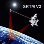
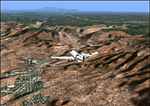
SRTM Version 2 is the result of a substantial editing effort by the National Geospatial Intelligence Agency and exhibits well-defined water bodies and coastlines and the absence of spikes and wells.
| Filename: | Turkey_Mesh_SRTM_V2_Part_II.zip |
| License: | Freeware |
| Added: | 25th January 2011, 14:32:45 |
| Downloads: | 2,882 |
| Author: | Tuncer Celik |
| Size: | 79.06 MB |
| Category: Flight Simulator 2004 - Scenery | |
| Turkey Mesh SRTM V2, Part I |
|
Images related to this file:
File Description:

SRTM Version 2 is the result of a substantial editing effort by the National Geospatial Intelligence Agency and exhibits well-defined water bodies and coastlines and the absence of spikes and wells.
| Filename: | Turkey_Mesh_SRTM_V2_Part_I.zip |
| License: | Freeware |
| Added: | 25th January 2011, 14:32:24 |
| Downloads: | 3,444 |
| Author: | Tuncer Celik |
| Size: | 88.4 MB |
| Category: Flight Simulator 2004 - AI Aircraft | |
| Lake Renegade AI_Land |
|
File Description:
This is my original Lake Renegade 250 converted for AI use. This one is for land only. A water version will follow later. It is available to scenery and flight plan designers.
| Filename: | Lake_Renegade_AI_Land.zip |
| License: | Freeware |
| Added: | 15th August 2005, 03:17:59 |
| Downloads: | 596 |
| Author: | John L. Woodward |
| Size: | 845.43 KB |
| Category: Flight Simulator 2004 - AFCAD Files | |
| Official Water Aerodromes located in Province of Quebec territory. |
|
File Description:
These are AFCAD2 Scenery files for most popular and visited waterbases located in the province of Quebec, Canada. Your Ai floatplanes will come alive with these "invisible" waterbases airports installed (AI traffic flightplans required.) and your flyable floatplanes will be allowed to take-off directly into water, at official water aerodromes, using FS9 airports menu. Thanks to Holger Sandmann who has developped this technique. Must be used with Gilles Gauthier's "Terrain Mesh Province of Quebec" for FS2004 and his excellent "Quebec Sceneries Enchancements".
| Filename: | Official_Water_Aerodromes_located_in_Province_of_Q.zip |
| License: | Freeware |
| Added: | 21st July 2006, 20:05:28 |
| Downloads: | 2,241 |
| Author: | Guy F. Jutras |
| Size: | 379.29 KB |
| Category: Fly! II - TerraScene | |
| Sedona, AZ Area TerraScene Project Pack |
|
Images related to this file:
File Description:
This TerraScene 2.1 Project pack covers all of global tile 176,154, with Sedona anchoring it just left of center. It extends from Sunset Crater in the NE southwest through Flagstaff, Sedona, Red Rock, and Prescott. This pack includes updated Tiger Census (2000) shapefile data, adding new water areas, new highways, and other details. All scenery data files are included: USGS data, shapefiles, an adapted texture set and a complete water mask. Requires TerraScene 2.1 and Fly!II patched to v230 or later.
| Filename: | Sedona_AZ_Area_TerraScene_Project_Pack.zip |
| License: | Freeware |
| Added: | 13th May 2010, 09:09:47 |
| Downloads: | 254 |
| Author: | Randall Rocke |
| Size: | 48.69 MB |
| Category: Fly! II - TerraScene | |
| Fayetteville (Carolinas Project) TerraScene Project Pack |
|
Images related to this file:
File Description:
This TerraScene 2.1 Project pack covers all of global tile 199,154, covering the area in and around the city of Fayetteville, NC. This tile includes Fort Bragg and Laurinburg as well as other towns in the sandhills region. This pack includes updated Tiger Census (2000) shapefile data, adding new water areas, new highways, and other details. All scenery data files are included: USGS data, shapefiles, and a complete custom water mask. Requires TerraScene 2.1 and Fly!II patched to v230 or later.
| Filename: | Fayetteville_Carolinas_Project_TerraScene_Project_.zip |
| License: | Freeware |
| Added: | 8th June 2010, 01:44:14 |
| Downloads: | 146 |
| Author: | Randall Rocke |
| Size: | 77.91 MB |
© 2001-2026 AVSIM Online
All Rights Reserved
Privacy Policy |