
Where Flight Simulation Enthusiasts Gather from Around the World!
AVSIM Library - Search Results

| Category: Flight Simulator 2004 - Scenery | |
| Perrine Bridge, Twin Falls Idaho Updated |

|
Images related to this file:
File Description:
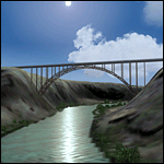
A prominent VFR landmark near Twin Falls Idaho, the Perrine Bridge spans over 1600' and stands 486 feet above the river below. At one time it was the tallest bridge in the world. Perrine Bridge is the only man-made structure in the USA were "base jumping" is allowed without a permit 365 days out of the year. Download includes gmax bridge object, a small photoscenery for the surrounding area, and two saved flight scenarios for exploring the scenery in the default J3 Cub. Bridge surface is landable and crash box has been removed allowing flight beneath the bridge. Scenery is compatible with, and nicely compliments John B. Loney's "Joslin-Magic Valley Regl" airport scenery (ktwf_v1.zip). Requires Ultimate Terrain and freeware mesh product, links provided in the readme.
| Filename: | Perrine_Bridge_Twin_Falls_Idaho_Updated.zip |
| License: | Freeware, limited distribution |
| Added: | 5th July 2011, 04:28:11 |
| Downloads: | 412 |
| Author: | Jim Robinson |
| Size: | 1.52 MB |
| Category: Flight Simulator 2004 - Gauges | |
| FS2004 GPS Map View Gauge v3.0 |
|
File Description:
The ultimate gauge. The Map will show: Airports details (Runways ID's, length & ILS), VOR's and NDB's frequencies,
Intersections and waypoints, Airspaces, Approaches and flight routes. You can toggle the view
you require for your flight. Also you can zoom in/out to see the nearest airports, vor's and
ndb's. The map will indicate A/C heading flightplan title and waypoints ID's.
Version 3 includes more enhancements such as the ability to input the ICAO code or name of any airport and the map will
show all the frequencies of that airport including ATIS, ILS, AND COM. In addition, the map will show the active
runway designations, length and width.
You can also input ICAO code of any VOR/NDB and the map will show their frequencies.
There was a bug in v2.0, in which if you enter ( click on ENT )the ICAO code of an airport, you will lose the flight
plan loaded. Now you can go back to the flight plan and with the NEXT/PREV buttons you have the choice of where to start
your FP.
The gauge will show Flight Plan Title, originating and destination airports, active waypoint, waypoint index and FP
crusing altitude.
I addition, the gauge will show various useful information, such as, Runway IDs, lenght, width and approach magnetic heading,
Airport name, city, and type. NAV1/2 names, codes, distances and ETA's, ADF1/2 names and codes.
Finally, the gaugee will show other information, such as, magvar, indicated airspeed, mach, ground velocity, ambient
wind velocity and direction, bank angle , and a/c altitude ( radio height ).
All the information above and much more on a single gauge window.
| Filename: | FS2004_GPS_Map_View_Gauge_v30.zip |
| License: | Freeware, limited distribution |
| Added: | 14th September 2005, 14:19:46 |
| Downloads: | 10,848 |
| Author: | Talal Alhaj |
| Size: | 710.05 KB |
| Category: Prepar3D V1-4 - Scenery | |
| Madonna della Corona Verona Italy N45.39.64 E10.53.34 |
|
File Description:
Madonna della Corona Verona Italy N45.39.64 E10.53.34 A sanctuary set in the Rock of Monte Baldo at about 1350 Ft in the Adige valley.The Corona Sanctuary is a place of silence and meditation, suspended between heaven and earth, hidden in the heart of the Baldo rocks. Medieval documents attest that already around the year 1000 in the Baldo area lived hermits linked to the Abbey of San Zeno in Verona and that at least from the second half of 1200 there existed a monastery and a chapel dedicated to S. Maria di Montebaldo accessible through a narrow and dangerous path in the rock. During the sixteenth century the two access stairs still visible were made: the widest, of 556 steps, which from the source of Spiazzi, then called "Fonte dell'Indipendenza", descended to the bridge of the lime tree, and the narrower one, of 234 steps, carved into the rock along the original narrow path that led from the bridge to the church. In 1974 the architect Guido Tisato was entrusted with the task of drawing up a project for a global intervention that envisaged the demolition of the existing Church, the preservation of the most valid and significant parts and the construction of a broader structure. Demolition and reconstruction of the Sanctuary were carried out between 1975 and 1978 and on June 4, 1978 the Bishop Giuseppe Carraro was able to proceed with the dedication of the new Sanctuary and the new altar. In 1982 the sanctuary was given the title "minor basilica". On April 17, 1988, Pope John Paul II visited and prayed to Our Lady of the Crown. Important VFR point for approaching airport Verona Villafranca e Verona Bosco Mantico. Within the downloaded package you will find readme files for scenery installatio, photos of site an flight plan. Good fly VFR. Pasquale Marrulli.
| Filename: | Madonna_della_Corona_Verona_Italy_N453964_E105334.zip |
| License: | Freeware |
| Added: | 4th May 2018, 04:44:39 |
| Downloads: | 154 |
| Author: | Pasquale Marrulli |
| Size: | 38.05 KB |
| Category: Flight Simulator X - Aircraft Repaints, Textures and Modifications | |
| Douglas C-47 (N65276) Frontier Airlines |
|
Images related to this file:
File Description:
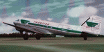
This folder contains a repaint for version 3.14 of the Douglas C-47 by Manfred Jahn and colleagues in the colors of Frontier Airlines N65276, one of the C-47/DC-3's operated by Frontier Airlines. On April 21, 1957, at 1321 hours, N65276, operating as Frontier Airlines flight 7 departed Prescott, Arizona enroute to Phoenix under visual flight rules (VFR) with 21 passengers and one stewardess. As the flight proceeded southbound toward Phoenix the weather deteriorated to a point where the flight could no longer remain clear of clouds and maintain VFR. Captain Welling requested and received an instrument flight rules (IFR) clearance to proceed to Phoenix via Knob intersection thence to the Phoenix omni range, maintain 7000 feet. The crew never acknowledged receiving the clearance. It is suspected that the reason there was no response is that this was the precise moment that flight 7 struck the west ridge of a mountain at the 4500’ level southeast of Prescott shearing off twelve feet of the left wing and six feet of the left aileron. After declaring an emergency, flight 7 landed safely at Phoenix Sky Harbor airport without further incident. There was no injury to the passengers or crew. The wing was replaced and the aircraft continued flying for Frontier. Sadly, N65276 was lost in a tragic accident in 1967 on a snowy Denver day when a rudder-lock had been placed on an elevator and not removed prior to take-off. Both pilots were killed in the crash. More info, as well as pictures, on these incidents, and an earlier mishap with N65276 can be found here: http://fal-1.tripod.com/FL_Crash.html.Repaint by Jan Kees Blom for Manfred Jahn's C-47 version 3.14, based on the paintkit by Gman5250.
| Filename: | Douglas_C47_N65276_Frontier_Airlines.zip |
| License: | Freeware |
| Added: | 14th August 2018, 21:34:27 |
| Downloads: | 382 |
| Author: | Jan Kees Blom |
| Size: | 13.82 MB |
| Category: Flight Simulator 2004 - AI Flight Plans | |
| Air New Zealand Link Winter 2005-2006 |
|
File Description:
Air New Zealand Link FlightPlans for the Winter 2005-2006 season. FlightPlans are based on the timetable data available on the Star Alliance and Air New Zealand websites at http://www.staralliance.com and http://www.airnewzealand.com. FlightPlans are based on the week 13.3.2006-19.3.2006. Air New Zealand Link is the regional feeder airline for Air New Zealand. It encompasses the airlines Air Nelson, Eagle Airways, and Mount Cook Airlines. Air New Zealand Link operates a fleet of ATR-72s, B1900Ds, Saab 340s, and the new Dash-8-Q300, the latter of which will replace the Saab 340. Air New Zealand Link flies to a number of regional destinations in New Zealand from its hubs in Wellington, Christchurch, and Auckland. In addition, they operate the route Palmerson North-Hamilton. This file is compatible with the MRAI installer. Enjoy!
| Filename: | Air_New_Zealand_Link_Winter_20052006.zip |
| License: | Freeware |
| Added: | 20th November 2005, 23:33:19 |
| Downloads: | 1,547 |
| Author: | Andreas Jozwiak |
| Size: | 23.55 KB |
| Category: Flight Simulator 2004 - Flight Plans | |
| PMDG SIDSTARS Cycle 0611 Collection |
|
File Description:
Collection of 37 SIDSTARS procedure files published for the 26Oct-23Nov06 cycle based on either FAA NACO Digital Terminal Procedures or edited updates of procedures developed by Terry Yingling with appreciation. The locations include: KABQ KATL KAUS KBNA KBWI KCMH KDAL KDEN KDFW KFLL KGEG KHOU KLAS KLAX KMCI KMCO KMDW KMSY KOAK KONT KORD KPDX KPHL KPHX KRDU KRNO KSAN KSAT KSEA KSFO KSJC KSLC KSMF KSNA KSTL KTPA KTUS. (Note: KSEA will require 0610 or later AIRAC data due to runway renumbering). There is general information provided in the enclosed readme, specific procedural information for each location in the header of each procedure file and a list of all changes by procedure enclosed. This cycle's collection has grown from the last with the addition of KDFW, KORD and KSFO.
| Filename: | PMDG_SIDSTARS_Cycle_0611_Collection.zip |
| License: | Freeware, limited distribution |
| Added: | 25th October 2006, 00:24:33 |
| Downloads: | 1,187 |
| Author: | Dan Downs |
| Size: | 176.85 KB |
| Category: Flight Simulator 2004 - Original Aircraft | |
| Cessna Citation Sovereign v2 |
|
File Description:
FS2004 Aircraft - In the late 1990s, Cessna saw the need for a high-performance jet midway between the Excel/XLS size and the Citation X. Initially, they looked at a clean-sheet design approach, but decided in the end to stretch the Excel's fuselage by almost five feet, and mate it with a new wing. The result is the Model 680 Citation Sovereign, powered by two Pratt & Whitney Canada PW306C turbofan engines with FADEC controls. With a typical cabin configuration, the Sovereing will seat eight passengers, with a maximum high-density capacity of 12, in addition to the crew of two. First flight of the Sovereign took place in February, 2002, with FAA certification awarded in June, 2004. Customer deliveries began later that fall. Created with FSDS2.10 by John B. Loney, Jr.
| Filename: | Cessna_Citation_Sovereign_v2.zip |
| License: | Freeware, limited distribution |
| Added: | 25th March 2007, 04:07:55 |
| Downloads: | 2,051 |
| Author: | John B. Loney, Jr. |
| Size: | 1.46 MB |
| Category: Flight Simulator X - Aircraft Repaints, Textures and Modifications | |
| Republic F-105D fictional 'Desert Storm' |
|
File Description:
This is a repaint of the Alphasim F-105D Thunderchief to represent a fictional RAF Thunderchief as it might have appeared (like the Buccaneer and Victor) in its last days of service during Desert Storm. The Thud would have been a plausible addition to the RAF's inventory during the mid-1960's as a stop-gap low-level supersonic fighter-bomber until the arrival of the TSR.2, and would have been well suited, with the right electronics suite and munitions, to the operations of Desert Storm. But failure of the TSR.2 programme would leave the RAF having to soldier on for at least 2 decades with an increasingly obsolescent and ageing fleet until the Tornado programme was fully geared up. Textures for both FS9 and FSX are included.
| Filename: | Republic_F105D_fictional_Desert_Storm.zip |
| License: | Freeware |
| Added: | 7th July 2008, 16:49:13 |
| Downloads: | 523 |
| Author: | Dave Quincey/Alphasim |
| Size: | 7.88 MB |
| Category: Flight Simulator 2004 - Scenery | |
| Washington D.C. - National Mall Update |
|
Images related to this file:
File Description:
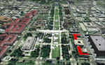
This is my first attempt for scenery modification for FS2004 using Googgle Sketchup buildings. I developed this scenery project to add more prominate buildings to the Washington DC area that were missing from the default scenery. All new buildings have been created and/or modified using Google Sketchup, converted with ModelConvertX and placed in FS2004 with InstantScenery. MegaScenery Mid Atlantic was used as a guide for accurate placement and makes a great addition, but is not necessary.
I went through great links to minimize the drawcall on each individual item to help reduce framerate hits. For my system, I found that setting the display settings in FS2004 to Medium High and turning off AI traffic was optimal while using both D.C. files in concert with MegaScenery. You might need to experiment.
| Filename: | Washington_DC__National_Mall_Update.zip |
| License: | Freeware |
| Added: | 4th August 2010, 19:31:56 |
| Downloads: | 1,624 |
| Author: | Larry Robbins |
| Size: | 52.41 MB |
| Category: Flight Simulator 2004 - AI Flight Plans | |
| Everts Air Alaska - Summer 2010 |
|
Images related to this file:
File Description:

Everts Air Alaska is a privately held corporation including sister companys Everts Air Cargo and Everts Air Fuel. Based in Fairbanks, Everts is the last operator of the venerable Douglas DC6/C118 and provides services throughout the interior of Alaska. In addition, Everts operates at least two Curtis C46s in daily operations. Everts has purchased all available DC6s, C118s, and C119s to use as parts for the DC6s. With the supply of spares, Everts figures that the DC6s will be in operation until 2015. Flights taken from FlightAware for the week of 25-31 July, 2010, and includes all flights. Everts also recently purchased three DC9-33Fs from ABX to use in their operations. Though, these aircraft have yet to enter service, N932AX has been painted in full Everts livery.
| Filename: | Everts_Air_Alaska__Summer_2010.zip |
| License: | Freeware |
| Added: | 7th August 2010, 22:10:09 |
| Downloads: | 1,783 |
| Author: | Steve Lewis |
| Size: | 197.5 KB |


© 2001-2026 AVSIM Online
All Rights Reserved
Privacy Policy |