
Where Flight Simulation Enthusiasts Gather from Around the World!
AVSIM Library - Search Results

| Category: Flight Simulator X - Panels | |
| F111 Panel.V1.1 |

|
Images related to this file:
File Description:
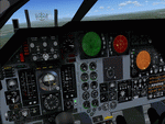
FSX Alphasim F111 Panel.V1.1 Features for FSX It includes a New VFR and IFR panel and updates to the virtual cockpit. New panel night lighting New virtual cockpit for the FB-111A cockpit with old Avionics package. I have cleaned up some of the gauge graphics. I have made improvements to the virtual cockpit cleaning up the graphics, and repositioned some gauges for a better fit to the panel. Terrain Following Radar added. Traffic Radar presented as Threat Warning Scope. More realistic afterbunner colors. Antenna graphics added to FB-111A nose side panels. New 'Sleepy Time Gal' and 'Spirit of the Seacoast' graphics. Now with install program.
| Filename: | F111_PanelV11.zip |
| License: | Freeware |
| Added: | 18th February 2007, 19:03:41 |
| Downloads: | 1,353 |
| Author: | Steve Hess |
| Size: | 7.52 MB |
| Category: Flight Simulator 2004 - Scenery Design | |
| Autotrees (automatic autogen file creation) beta v0.1 |
|
File Description:
Autotrees was created to automatically write any number of autogen files. It will only produce files containing trees, and I can't see a way to produce buildings the same way. It was written using UK VFR Photographic Scenery as a testbed, but should work with any photoreal ground textures. The accuracy of the output is very much dependant on the quality of the texture files used. The included jpegs are all "untouched" taken after a couple of seconds running Autotrees.
Autotrees can produce over 120 files per minute on an AMD 2.0 Ghz computer. Thats over a million trees an hour; how's that for global offsetting!
| Filename: | Autotrees_automatic_autogen_file_creation_beta_v01.zip |
| License: | Freeware, limited distribution |
| Added: | 2nd November 2007, 23:35:34 |
| Downloads: | 3,330 |
| Author: | David J Griffiths |
| Size: | 442.33 KB |
| Category: Flight Simulator X - Scenery | |
| Savannah, Georgia - USA |
|
Images related to this file:
File Description:
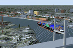
A large and detailed scenery of Savannah, Georgia. Includes downtown Savannah
and riverfront (with custom made buildings, hotels, convention center, gold domed
courthouse, and Talmadge Bridge), harbor with container terminal, AI ship traffic, and
a custom built streetcar to travel the downtown streets of Savannah.
KSAV Savannah/Hilton Head Intl Airport has a custom built terminal, Gulfstream factory, and Air National
Guard facility. KSVN Hunter AAF has a custom built US Coast Guard facility and AI helicopter
traffic. Coastal Tybee Island is represented with beachfront resorts and hotels, pier,
shopping district, and 2 functioning lighthouses. Great for the VFR flyer!
By Dan French.
| Filename: | Savannah_Georgia__USA.zip |
| License: | Freeware, limited distribution |
| Added: | 21st April 2014, 22:57:17 |
| Downloads: | 1,143 |
| Author: | Dan French |
| Size: | 11.51 MB |
| Category: Flight Simulator 2004 - Scenery | |
| Astrakhan City topology and autogen |
|
Images related to this file:
File Description:
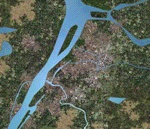
I'm pleased to introduce you the project of topology and autogen of Astrakhan city, Russia, version 1.0b. The project is for MS Flight Simulator 2004.
This projects changes the default autogen of the city and its neighborhood, that doesn't correspond to the real city. Also it adds missing rivers, islands, roads, railroads, and bridges in the vicinity of the city and Astrakhan aerodrome (URWA) and removes non-existent bridges across the Volga river.
This scenery is not professional since I designed it to my own cheek in Ground2K4 to replace the default terrible scenery and make my flights to homeland more comfortable. That's why it is probable, that you can face some challenges (although, I didn't see any problems yet). The project has several disadvantages: all bridges are autogen, so they don't look very similar to real ones (but they are better, that their absence and presence of several non-existent :) ); no autogen on added islands (although the autogen option for them is set on in Ground2K4), I will continue to work on it; rivers that fall into the Volga river have the default shoreline visible at theirs mouths (it's possible to remove it, but only on the square of big area, in that case the river-land transition doesn't look real).
Overall, this project is more for IFR flights, than VFR. But, again, even for VFR flights it's much better than the default crap (imho!).
| Filename: | Astrakhan_City_topology_and_autogen.zip |
| License: | Freeware |
| Added: | 2nd July 2010, 15:18:39 |
| Downloads: | 434 |
| Author: | Valery 'Oracle' Smirnov |
| Size: | 11.23 KB |
| Category: Flight Simulator 2004 - Scenery | |
| Aspen (KASE), Colorado, Photo-Scenery (FS9 & FSX) |
|
Images related to this file:
File Description:
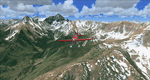
There sure is more than one reason to go to Aspen and this is sure another must-have of my Colorado sceneries. If you're coming IFR there's a couple of very demanding approach procedures. From a LOC/DME to several visual approaches there's everything your heart might desire. Due to the steep and high surrounding terrain these are quiet some hair raisers (see www.airnav.com/airport/KASE). If you're coming VFR then the traffic pattern altitude is 9.005 ft for light aircraft (vs. 9.505 for aircraft 12.500 lbs or more). Weather and wind permitting, RW15 is preferred for all landings (left pattern). RW33 has a right pattern and is preferred for all takeoffs. You even need a written permission to depart RW15. When departing VFR make a right turn to a heading of 360 degrees ASAP for noise abatement and hold this heading for at least 2 miles from the field. And don't forget to enjoy the impressive mountain scenery with two 14ers: Snowmass Mtn. and Castle Pk. to the southwest. This scenery brings you another 3.500 sq km of beautiful Colorado in 4.7m/pix quality. High resolution versions of this scenery for FS9 and FSX (much sharper, but larger and multiple downloads) are available at www.blueskyscenery.com/GNB_South2West2.html . The screenies are taken from the high-res versions, so expect this version to be slightly more blurry. YourDonation@Work: Dedicated to Mark, Markus and Yves.
| Filename: | Aspen_KASE_Colorado_PhotoScenery_FS9__FSX.zip |
| License: | Freeware, limited distribution |
| Added: | 30th January 2010, 17:04:55 |
| Downloads: | 3,584 |
| Author: | Gottfried Razek - blueskyscenery.com |
| Size: | 92.5 MB |
| Category: Flight Simulator 2004 - Flight Plans | |
| Von Humboldt's Latin America expedition |
|
File Description:
Friedrich Wilhelm Heinrich Alexander Freiherr von Humboldt (September 14, 1769 - May 6, 1859) was a German naturalist and explorer. Between 1799 and 1804, Humboldt traveled extensively in Latin America, exploring and describing it for the first time in a manner generally considered to be a modern scientific point of view. On June 5, 1949 (150 years after Von Humboldt's departure) our journey begins in La Coruna, Spain, in Lufthansa's Dornier Do-26 flying boat to follow this example. Since Von Humboldt also made many in-land journeys on the South-American continent, we use the Junkers Ju-52 for our continental VFR flights. Requires do26.zip, embflaw.zip, kedigau.zip, ju52v60b.zip, and ju52v60update1.zip
| Filename: | Von_Humboldts_Latin_America_expedition.zip |
| License: | Freeware |
| Added: | 29th January 2010, 21:19:55 |
| Downloads: | 101 |
| Author: | Nis Verkijk |
| Size: | 844.96 KB |
| Category: Flight Simulator 2004 - Flight Plans | |
| U.S. Territories - Low Altitude |
|
Images related to this file:
File Description:
FS2004 Low Altitude Flight Plan for the U.S. Territories - This package includes 9 individual FS2004 flight plans for current IFR, VFR and Slow Speed Routes in the US. Territories of Guam and Puetro Rico. These are great routes for B-52, F-111, B-1B, B-2 A6, A4, Vulcan and any fighter or bomber enthusiasts. Of course you can fly the route with any aircraft of your choice. Also included in this package is Karol Chlebowski's TFR guage. This gauge will greatly enhance your ability to fly these challenging routes and are a great companion of the flight plans. Another option is to download Version 2.0 of my FS9 mini panel which has all this functionality and more.
| Filename: | US_Territories__Low_Altitude.zip |
| License: | Freeware |
| Added: | 20th September 2011, 13:58:27 |
| Downloads: | 192 |
| Author: | Bill McClellan |
| Size: | 1.21 MB |
| Category: Flight Simulator X - Scenery | |
| BariCity |
|
File Description:
The filmmakers FSX they have not taken into account the city's Italian,
therefore, I decided to make some Italian cities such as the city of Bari.
The scenarios are always built airports, but few are interested in the VFR flight
where the details of the land and the cities are important for the flight.
In the package you will find the file Baricity.bgl that will be placed at the
addon scenery folder and subfolder scenery automatically when FSX scenery you will find it
in the scenario.
In scenery you can fly over the port, the castle and the church of San Nicola.
Good flight at all. We accept criticism and advice. Contact info in Readme.txt file.
| Filename: | BariCity.zip |
| License: | Freeware |
| Added: | 28th June 2015, 00:06:53 |
| Downloads: | 214 |
| Author: | Pasquale Marrulli |
| Size: | 11.21 KB |
| Category: Prepar3D V1-4 - Scenery | |
| Grise Fiord Airport (CYGZ) N76.25.34 W82.54.36 |
|
File Description:
Grise Fiord Airport (CYGZ) N76.25.34 W82.54.36 is located in the Qikiqtaaluk Region of the territory of Nunavut, and is one of the northernmost inhabited settlements of Canada and the whole world. The scenario shows the airport infrastructure and the small town not far from the airport. This scenario goes to fill the absence of scenarios towards the North Pole. The airport is open only in the mei that go from August to October where it is practically possible to land considering also the proximity of mountains remains one of the most difficult and dangerous airports.
Within the downloaded package you will find readme files for scenery installation. Good fly VFR. Pasquale Marrulli.
| Filename: | Grise_Fiord_Airport_CYGZ_N762534_W825436.zip |
| License: | Freeware |
| Added: | 30th December 2017, 19:14:28 |
| Downloads: | 149 |
| Author: | Pasquale Marrulli |
| Size: | 2.97 KB |
| Category: Flight Simulator 2002 - Flight Plans | |
| 38RTWest |
|
File Description:
An FS2002 GPS flight Plan. The 38th in a series of Round the World flight plans for the FS2002 default scenery. Depart Thoise (Z13Q) runway 29, India and arrive 1 hour 24 minutes later at Kabul (OAKB) runway 29, Afghanistan. A very scenic flight. A climb up a valley followed by a tour between the mountain peaks and descent into a valley for the approach is featured. Keep a sharp lookout for you know who, there is a substantial reward still on offer. A VFR finals is featured (hand holding instructions given). The flight briefing (Word and text) is for a B737-400, it contains climb, cruise, top of descent and fuel loading details, waypoint timings and destination details.
| Filename: | 38RTWest.zip |
| License: | Freeware |
| Added: | 10th August 2002, 15:47:22 |
| Downloads: | 784 |
| Author: | The Ancient Brit |
| Size: | 26.97 KB |


© 2001-2026 AVSIM Online
All Rights Reserved
Privacy Policy |