
Where Flight Simulation Enthusiasts Gather from Around the World!
AVSIM Library - Search Results

| Category: Flight Simulator 2004 - Flight Plans | |
| "Imperial 109" - The journey of Imperial Airways S.23 "Caterina" in 1939, from the novel by Richard Doyle. |

|
File Description:
In 1977 the novel "Imperial 109", by Richard Doyle, was published. The story is based on the flight of an Imperial Airways Short 'Empire' Class flying-boat, "Caterina", on its journey through Africa to Cairo and onwards through Europe to England and finally across the Atlantic to New York. When I read this novel just recently I couldn't help but think that it would make a wonderful Flight for Flight Simulator, and the fact that the characters and storyline was fiction was of no concern, because the airline, the aircraft and the route flown were real. I also considered that the best way to present this was to publish it as an unfolding story in blog format, in the same fashion as the Sir Alan Cobham flight around Africa which I had undertaken. Therefore I present you with "Imperial 109" for Microsoft Flight Simulator and you can take part by following and flying the updates as I present them online.
| Filename: | Imperial_109__The_journey_of_Imperial_Airways_S23_.zip |
| License: | Freeware |
| Added: | 27th September 2007, 12:59:21 |
| Downloads: | 954 |
| Author: | Bruce Kennewell |
| Size: | 51.57 KB |
| Category: Flight Simulator X - Scenery | |
| 70 Colombia Airports |
|
File Description:
70 Colombia airports/airfields for FSX. Mainly based on GoogleEarth. Changes to default airports and many new airports added. Largely based on my formerr FS9 colombian airport sceneries. I am using the FreeMesh X Global 1.0 from https://www.avsim.com/forums/topic/467933-freemesh-x-global-10-release-announcement/ but most sceneries should work also with the default or any other mesh. All files start with the ICAO identifier of the airport; so you can take out what you don't like or use only what you like.
Airports included are: ACM (IATA Code), SK53,SKAG,SKAO (now SKMJ) SKAS, SKBC, SKBE, SKBM, SKBN, SKBQ, SKBS, SKBU, SKCA, SKCB, SKCI, SKCN, SKCR, SKCZ, SKEB, SKFE, SKFL, SKGA, SKGI, SKGY, SKHA, SKHC, SKIB, SKIM, SKIO, SKIR, SKLA, SKLB, SKLC, SKLP, SKLT, SKMF, SKMG, SKMO, SKMO, SKNA, SKNV, SKOE, SKOT, SKPA, SKPD, SKPI, SKPP, SKPV, SKPZ, SKQU, SKRI, SKSA, SKSF, SKSJ, SKSV, SKTB, SKTM, SKTQ, SKUA, SKUM, SKUR, SKVG,
SLVP, SQFR, SQOA, SQPS, SQUJ, SQVZ, Z09A
| Filename: | 70_Colombia_Airports.zip |
| License: | Freeware |
| Added: | 6th January 2019, 17:39:01 |
| Downloads: | 2,412 |
| Author: | Detkev J. Rohmer |
| Size: | 106.4 MB |
| Category: Flight Simulator X - Aircraft Repaints, Textures and Modifications | |
| Boeing B-17G 91st BG (OR-L) "Blue Dreams" |
|
Images related to this file:
File Description:
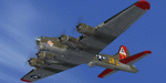
This folder contains a repaint for the A2A WoP2 B-17G in the colors of B-17G-10-DL 42-37761 OR-L "Blue Dreams" of the 323rd BS/ 91st BG, based in Bassingbourne, UK. "Blue Dreams" was assigned to Captain Ken McFarland and his crew, and was painted by Corporal Tony Starcer, with the december pin-up by Alberto varga. When the crew found out that their captain's wife was pregnant, they had Starcer paint a stork and baby below the pilots window (without McFarlane knowing), adding the name 'Mona Gail'after the birth of his daughter. The aircraft would go on to complete 29 missions with the group, before being written off due to an unfortunate oversight by another crew. Shortly after taking off for a flight to Berlin, on the 6th of March 1944, the pilot, Lt Walter Wilkinson, noticed fuel streaming from the starboard wing. He decided to land immediately, in the hope of quickly solving the problem and rejoining the mission. The nearest airfield was the 355th FG's base at Steeple Morden, close to Bassingbourne, and he decided to land there. He lined up with the runway and slowly descended the heavily laden bomber, going for a smooth as possible landing. What came was different, since the crew had forgotten to lower the landing gear, and "Blue Dreams" screeched of the runway and into the grass. The crew evacuated the wrecked aircraft as quickly as they could, but fortunately, the bombs in the bomb-bay did not explode. "Blue Dreams" would not fly again, and was salvaged the following day. The subsequent accident report revealed that the pilot had flown 8 exhaustive missions in the previous two weeks. This time nobody was hurt, but it would be a different story 10 months later, when another 91st B-17 forcelanded at Steeple Morden...
Repaint by Jan Kees Blom, based on the A2A paintkit.
| Filename: | Boeing_B17G_91st_BG_ORL_Blue_Dreams.zip |
| License: | Freeware |
| Added: | 7th October 2019, 18:19:18 |
| Downloads: | 100 |
| Author: | Jan Kees Blom |
| Size: | 17.66 MB |
| Category: Flight Simulator 2004 - Scenery | |
| Koyukuk KYU in Alaska |
|
Images related to this file:
File Description:
Koyukuk is a small village on the northern bank of the Yukon River, around 5 miles east of where the river turns from north-south to east-west, east being upstream towards the distant Fairbanks. The mouth of the Koyukuk River that joins the Yukon is just to the east of the village. The population is now under 100 and living from fishing and the land. During the late 1800's the local population lived off the land and also by the spin off from gold mining in the same way as the nearby Nulato, but when in the early 1900's gold mining activities moved to Nome and Fairbanks local prosperity plunged. In fact, the village only became a permanently inhabited establishment in 1939, when a school was built. The airfield is close by and has a gravel runway aligned 6-24 and 4,000 feet long with PAPI on the approach to 6. There is also a shorter and parallel grass runway that is only used in the winter snows by light planes that are on skis and without wheels. Apart from the airfield itself, and it's buildings, this scenery modifies the local land class, adds village buildings while reducing the village size to reality, and creates a new airfield background. Koyukuk is served by Wright Air from Fairbanks in the east and this is included in the AI provided with the post of Nulato. A note here about my scenery making. This is post number 509 and there will not be many more to follow this as I am almost at the end of the photos I either took or found for scenery purposes. There is a limit to what can be located online and I have already been making use of the little there is; eg Unalakleet. So, if you are near an airport (preferably Canadian or Alaskan) and have a camera..... Let me know.
| Filename: | Koyukuk_KYU_in_Alaska.zip |
| License: | Freeware, limited distribution |
| Added: | 30th August 2019, 18:23:12 |
| Downloads: | 124 |
| Author: | Roger Wensley |
| Size: | 3.26 MB |
| Category: Flight Simulator X - Scenery | |
| MYXY - Duncan Town, Ragged Island Chain, Bahamas - Version 2 |
|
File Description:
The Ragged Island Chain consists of a string of small islands in the Bahamas. Only one island, Ragged Island, has a settlement on it which is known as Duncan Town. This FSX scenery improves the airstrip at Duncan Town and creates a new private airstrip on Nurse Cay. The airstrip at MYXY (Duncan Town) has been lengthened by 500 feet and widened by 25 feet. Six parking ramps now exist as well as a fuel pump and helipad. Additional taxiways have been added and lights for the runway, taxiways and apron. A small building has been added to serve as a combined terminal, control tower, and customs office. There is also a hangar to protect your plane from tropical storms. These improvements were necessary to accomodate the increased air traffic due to the new high rise tropical hotel, the Ragged Island Resort. There is also a lighthouse on the island and a cruise ship with helipad just off to the east. A large private yacht just to the north also has a helipad. You can watch dolphins swim at both of those locations - the helipads make great viewing spots. About 20 miles north of Ragged Island is Nurse Cay (MYXN). This is where my private airstrip and villa are located. The airstrip has a 2500 ft concrete runway and a parallel taxiway as well as a helipad. The runway, taxiways, and apron are all lit for night operations. The airstrip was built right on a marsh so wandering off the runway or taxiways could result in getting wet. You will find a variety of birds flying around at various locations throughout this scenery. A flight plan is also included for a dusk flight from Ragged Island (MYXY) to Nurse Cay (MYXN). So come on out to Ragged Island, because it's better in the Bahamas! This is version 2 and supercedes my original file - this version corrects the runway numbers at MYXN.
| Filename: | MYXY__Duncan_Town_Ragged_Island_Chain_Bahamas__Ver.zip |
| License: | Freeware |
| Added: | 24th August 2007, 15:55:49 |
| Downloads: | 2,408 |
| Author: | Mike Lanza |
| Size: | 13.43 KB |
| Category: Miscellaneous Files - Miscellaneous Files | |
| CPS-NG RC 5 |
|
File Description:
CPS-NG (Concorde Performance System New Generation) is the successor to CPS-X, the essential flight preparation utility created in 2011
and discontinued in 2018.
Since the end of its development, still present on AVSIM despite a large number of unavailable functions, it has been downloaded more
than 3000 times.
This new CPS opus will satisfy the most demanding Concorde simulation enthusiasts.
CPS-NG now makes it possible to plan Concorde flights with the following simulators:
FsLabs Concorde X for FSX, and P3D up to version 3.
Colimata Concorde FXP for X-Plane and Gaston Reif's beautiful mod, Heritage Concorde Avionics Package.
With these simulators, CPS-NG can export waypoints to INS, payload and fuel to aircraft.
Like its illustrious predecessors, CPS-NG uses authentic Air France data and charts.
It offers a map of the flight including the navigation points, the points to protect from the supersonic bang, on departure and on
arrival
The flight preparation stages are done in a user-friendly way.
the subsonic levels are configurable, the anti-noise procedures are calculated as in reality. The loading of the plane is modifiable by
the user in order to obtain the ideal centering.
The fuel is calculated as in reality and its distribution in the 11 tanks of Concorde complies with the filling law of Air France and
British Airways.
CPS-NG like its previous version also offers the user a flight report in the form of a PDF document which contains all the elements
necessary for the preparation of the aircraft.
it also offers Concorde-specific settings such as initial climb angle, time until anti noise procedure, throttle levers angle during
anti noise procedure, fuel flow, maximum pressure in P7,
trim adjustment and everything a pilot and flight engineer could want for a perfect flight.
CPS-NG also offers in the flight report, Take-off and landing forms in accordance with the real documents and the user has the choice
between the Air France form and the British Airways one.
Finally, CPS-NG allows the use of real-time weather from NOAA, personalized weather or the one generated by Active Sky 2016,
Active Sky for P3D and Active Sky for X-Plane 11 or 12.
In summary, here you have the ultimate tool for Concorde simulation.
You dreamed it, we did it!
Break the sound barrier.
| Filename: | CPSNG_RC_5.zip |
| License: | Freeware |
| Added: | 10th August 2023, 15:48:00 |
| Downloads: | 72 |
| Author: | Pierre Chassang |
| Size: | 19.49 MB |
| Category: Miscellaneous Files - General Utilities | |
| CONCORDE PERFORMANCE SYSTEM NEW GENERATION |
|
File Description:
CONCORDE PERFORMANCE SYSTEM
NEW GENERATION
CPS-NG (Concorde Performance System New Generation) is the successor to CPS-X, the essential flight preparation utility created in 2011
and discontinued in 2018.
Since the end of its development, still present on AVSIM despite a large number of unavailable functions, it has been downloaded more
than 3000 times.
This new CPS opus will satisfy the most demanding Concorde simulation enthusiasts.
CPS-NG now makes it possible to plan Concorde flights with the following simulators:
- FsLabs Concorde X for FSX, and P3D up to version 3.
- Colimata Concorde FXP for X-Plane and Gaston Reif's beautiful mod, Heritage Concorde Avionics Package.
With these simulators, CPS-NG can export waypoints to INS, payload and fuel to aircraft.
Like its illustrious predecessors, CPS-NG uses authentic Air France data and charts.
It offers a map of the flight including the navigation points, the points to protect from the supersonic bang, on departure and on
arriva.
The flight preparation stages are done in a user-friendly way.
the subsonic steps are configurable, the anti-noise procedures are calculated as in reality. The aircraft loading is modifiable by
the user in order to obtain the ideal centering.
The fuel is calculated as in reality and its distribution in the 11 tanks of Concorde complies with the filling law of Air France and
British Airways.
CPS-NG like its previous version also offers the user a flight report in the form of a PDF document which contains all the elements
necessary for the preparation of the aircraft.
it also offers Concorde-specific settings such as
- Initial climb angle.
- Time to anti noise procedure.
- Throttle levers angle during anti noise procedure.
- Fuel flow.
- Maximum pressure in P7 compressor.
- Trim adjustment and everything a pilot and flight engineer could want for a perfect flight.
CPS-NG also offers in the flight report, Take-off and landing forms in accordance with the real documents and the user has the choice
between the Air France form and the British Airways one.
Finally, CPS-NG allows the use of real-time weather from NOAA, personalized weather or the one generated by Active Sky 2016,
Active Sky for P3D and Active Sky for X-Plane 11 or 12.
In summary, here you have the ultimate tool for Concorde simulation.
NOTE: The manual curently in writing, thanks for your patience.
You dreamed it, we did it!
Break the sound barrier.
| Filename: | CONCORDE_PERFORMANCE_SYSTEM_NEW_GENERATION.zip |
| License: | Freeware, limited distribution |
| Added: | 20th July 2023, 05:20:23 |
| Downloads: | 130 |
| Author: | Pierre Chassang |
| Size: | 19.49 MB |
| Category: Prepar3D V5 - AFCAD Files | |
| KLZU - Gwinnett County Airport (Briscoe Field) | Lawrenceville, Georgia |
|
File Description:
This is a modification of the stock Gwinnett County Airport (KLZU) AFCAD/BGL for Prepar3d v5.4. Almost the entire airport has been redone using library objects and generic building files in Prepar3d and matches pretty close to what is shown in Navigraph Charts. Aircraft parking around the airport has been randomized based off Google Maps images. Also included is an exclusion bgl to remove trees and flatten the scenery on the East side of the airport on taxiway Y which did not exist in Prepar3d.
All taxiway names in the original airport were incorrect, this has been corrected. Taxi signage around the airport matches locations/intersections and additional signs have been added where they should have been to begin with.
Control tower and wind socks have been relocated to where they are in real life and according to Navigraph.
I hope you enjoy this scenery and look forward to sharing more in the future!
| Filename: | KLZU__Gwinnett_County_Airport_Briscoe_Field__Lawre.zip |
| License: | Freeware |
| Added: | 10th December 2023, 23:02:50 |
| Downloads: | 28 |
| Author: | Michael Johnson |
| Size: | 227.99 KB |
| Category: Prepar3D V1-4 - Aircraft Repaints, Textures and Modifications | |
| Martinair 1998 AI Flightplans |
|
File Description:
Martinair was Holland's premiere charter outfit for many years before consolidating to an all-cargo operation several years back. In 1998, Martinair had a large scheduled operation to supplement their charter operations with 747-200s, MD-11s, and 767-300s. The 747's only scheduled route was a weekly flight to Cancun(CUN/MMUN), the rest of the 747 flights are charters. All scheduled flights are included as well as charters that I based off information found around the internet and a wide range of destinations are served. Note that the airline was celebrating it's 50th anniversary in 1998 and many of the aircraft had special titles. Flightplans by Chasen Richardson. Michael Pearson has painted the fleet and filenames to his textures are included. Part of the 1998 Flight Simulator Project. Follow us on Facebook at facebook.com/flightsim98 and on instagram as @bayviationsim. For more Retro AI, check out the forums at: http://retroai.proboards.com/
| Filename: | Martinair_1998_AI_Flightplans.zip |
| License: | Freeware, limited distribution |
| Added: | 21st November 2019, 19:19:38 |
| Downloads: | 95 |
| Author: | Chasen Richardson\Bayviation |
| Size: | 790.58 KB |
| Category: Flight Simulator X - Scenery | |
| RAF Manston 1944 |
|
File Description:
RAF Manston (ICAO EGMH)was an RAF station in the north-east of Kent, on the Isle of Thanet from 1916 until 1996. The site is now split between a commercial airport Kent International Airport (KIA) and a continuing military use by the Defence Fire Training and Development Centre (DFTDC), following on from a long-standing training facility for RAF firefighters at the Manston base.
Source: Wikipedia
I have represented it here in 1944 leading up to its part in Operation Market garden and D Day. It was one of the few airfields installed with the Fog Investigation Dispersal Organisation (FIDO) system designed to remove fog from airfields by burning it off with petrol and I have represented this with the 8 fuel tanks at the 29 end of the mail runway. I have laid the station out roughly according to an old map made in the mid 40s but I make no claims to the accuracy of building I have used.
| Filename: | RAF_Manston_1944.zip |
| License: | Freeware |
| Added: | 26th April 2016, 00:15:35 |
| Downloads: | 160 |
| Author: | Terry Boissel |
| Size: | 1.71 MB |
© 2001-2026 AVSIM Online
All Rights Reserved
Privacy Policy |