
Where Flight Simulation Enthusiasts Gather from Around the World!
AVSIM Library - Search Results

| Category: Prepar3D V1-4 - Missions | |
| BridgeCrash.zip |

|
File Description:
Beginner helicopter mission for P3D V3.4. (May or may not work in V2). Fly a rescue mission to a bridge crash and take the victims to a local hospital.
| Filename: | BridgeCrashzip.zip |
| License: | Freeware |
| Added: | 1st September 2017, 18:54:03 |
| Downloads: | 133 |
| Author: | HeloMissionMan |
| Size: | 19.09 MB |
| Category: Flight Simulator X - Aircraft Repaints, Textures and Modifications | |
| FSXC Boeing 747-400 |
|
File Description:
747-400 Exclusive FSX Contest Livery
Enjoy, have fun !!!
Take some screenshots or videos and send them to www.facebook.com/fsxcontest
Thanks a lot
FSX Photo and Video Contest Team
| Filename: | FSXC_Boeing_747400.zip |
| License: | Freeware, limited distribution |
| Added: | 18th April 2014, 05:59:01 |
| Downloads: | 29 |
| Author: | Kristof De Vos, Vista Repaint, FSX Photo and Video Contest; fsxcontest |
| Size: | 1.99 MB |
| Category: Flight Simulator X - Miscellaneous Files | |
| X52 Configuration |
|
File Description:
for all who have the x52 flight control system .
this i have made , because the original fsx.dat is for x52pro.
take this one in your x52 softwaremap & profile now !
| Filename: | X52_Configuration.zip |
| License: | Freeware |
| Added: | 31st December 2008, 12:25:03 |
| Downloads: | 895 |
| Author: | ceyssens peter |
| Size: | 18.73 KB |
| Category: Flight Simulator 2004 - Flight Plans | |
| DC3 Intra Airways |
|
File Description:
This was the original aircraft that started Intra in the late sixties and led through expansion, take overs, and after becomming Jersey European, then British European is now Flybe:
| Filename: | DC3_Intra_Airways.zip |
| License: | Freeware |
| Added: | 30th September 2004, 04:51:32 |
| Downloads: | 413 |
| Author: | Garry Russell |
| Size: | 1.69 MB |
| Category: Flight Simulator X - Missions | |
| TriesteCastleTour.zip |
|
File Description:
Helicopter mission. A helicopter stationed at LIPQ airport provides services. Take tourists out to see the castles of Duino, Miramare, and San Guisto in the Trieste area of Italy.
| Filename: | TriesteCastleTourzip.zip |
| License: | Freeware |
| Added: | 8th June 2024, 17:40:55 |
| Downloads: | 41 |
| Author: | helomissionman |
| Size: | 3.47 MB |
| Category: Flight Simulator 2004 - Scenery | |
| Invermere CAA8 in British Columbia, Canada |
|
Images related to this file:
File Description:
This airfield is in the Columbia Mountains (which are part of the Rockies) on the border between BC and Alberta. Invermere is in the same valley as Golden, 65 miles south and midway between Golden and Cranbrook. The town is at the northern end of Lake Windermere, on the western side, with a population of around 3,400. The main touristic feature of Invermere appears to be the provision of a wide choice of golf courses. These are included in the scenery, as are some of the surrounding commercial buildings including a nearby hotel and retail units. Invermere CAA8 is half a mile northeast of the lake, and is home to the non-profit Canadian Rockies Soaring Club that trains pilots during the summer months. The Invermere Soaring Centre, a separate organisation, provides glider towing services and rides for the general public. During the summer the airfield can only be described as busy, with gliders taking advantage of the terrain for ridge soaring. The AI here includes gliders that will take off and then circle around north of the field. The take off is not a realistic glider style launch, and the wind should be from the north; these gliders do not taxi and then turn around at the far end of a runway too well. Once again, like Golden, there is no runway or taxiway lighting, so daylight use only. There are GA visitors to CAA8 between the gliders, presumably carrying golfers and clubs. Due to the surrounding terrain AI aircraft might impact high ground before landing and then just show up on their parking spot.
| Filename: | Invermere_CAA8_in_British_Columbia_Canada.zip |
| License: | Freeware, limited distribution |
| Added: | 16th October 2018, 02:11:34 |
| Downloads: | 166 |
| Author: | Roger Wensley |
| Size: | 6.11 MB |
| Category: Prepar3D V1-4 - Utilities | |
| FSX/FSXSE/Prepar3D FS Flight Builder |
|
Images related to this file:
File Description:
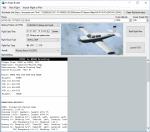
FS Flight Builder - UPDATE - You can now get
charts for airports worldwide. Color coding
has also been added for the departure and
destination airports to indicate flight
conditions. FS Flight Builder is a flight
making application for FSX/FSX Steam
Edition, and Prepar3D. Flight routes can be
imported from the SkyVector Plain Text Link
or added manually. Automatically adds a
briefing file to the aircraft kneeboard.
By Tom Arduini
| Filename: | FSXFSXSEPrepar3D_FS_Flight_Builder.zip |
| License: | Freeware, limited distribution |
| Added: | 24th January 2017, 00:48:40 |
| Downloads: | 795 |
| Author: | Tom Arduini |
| Size: | 7.35 MB |
| Category: Navigation and ATC - Navigation | |
| Puerto Rico VI TAC Chunks for Aerosoft's FSMap |
|
File Description:
The chart chunks are from the latest Puerto Rico Virgin Islands TAC at the original scale, formatted in the WGS84 lat/long geographic coordinate system for the FSMap, moving map application for flight simulation use.
The chart chunks are baseline 8bit tiffs with packbit compression applied, not for size but for efficiency. The images are 3800x3806 pixels at about 13.5mb each. Also, included is the FSMap fsm Calibration file for importing.
| Filename: | Puerto_Rico_VI_TAC_Chunks_for_Aerosofts_FSMap.zip |
| License: | Freeware |
| Added: | 19th March 2010, 01:17:08 |
| Downloads: | 323 |
| Author: | David Myers |
| Size: | 21.19 MB |
| Category: Flight Simulator X - Utilities | |
| FSVNAV (Flight Simulation Vertical Navigation) |
|
File Description:
FSVNAV is an external Vertical Navigation gauge for both FSX and FS2004. A complete waypoint database is included with both latitude and longitude coordinates to facilitate ease of use. By entering the crossing waypoint, crossing altitude and a VS Profile (not required), the gauge will command your autopilot for a perfect crossing restriction. Application is networkable with a licensed copy of WideFS. FSUIPC is required (Registered or Free).
| Filename: | FSVNAV_Flight_Simulation_Vertical_Navigation.zip |
| License: | Freeware |
| Added: | 24th February 2009, 03:32:11 |
| Downloads: | 1,889 |
| Author: | Brian Pollock |
| Size: | 6.95 MB |
| Category: Flight Simulator 2004 - Scenery | |
| Trecate - SanMartino scenery, NW Italy |
|
Images related to this file:
File Description:
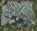
This is a VFR scenery for the industrial pole (refinery) S. Martino di Trecate (NO - NW Italy). In reality, all of the scheduled flights approaching Malpensa (LIMN) cross this area, aligning to route 350, for the two runways 35L and 35R. The scenery DOES NOT INCLUDE any airport.
- It requests application of libraries "dva51" (mainly used) and Treeplanter system libraries. Enjoy!
Video available here https://youtu.be/qJkBnAJrYZo
| Filename: | Trecate__SanMartino_scenery_NW_Italy.zip |
| License: | Freeware |
| Added: | 21st September 2014, 23:26:38 |
| Downloads: | 1,181 |
| Author: | Aldo Della Vedova, Daniele Lanfranchi |
| Size: | 22.3 MB |
© 2001-2026 AVSIM Online
All Rights Reserved
Privacy Policy |