
Where Flight Simulation Enthusiasts Gather from Around the World!
AVSIM Library - Search Results

| Category: Flight Simulator X - Scenery | |
| CYXX (2012) Version 2 for FS9, FSX and Prepar3D |

|
Images related to this file:
File Description:

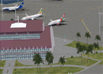
CYXX (2012) portrays the Abbotsford (British Columbia, Canada) Airport - home of the Abbotsford Air Show - and surrounding area as it appeared in late 2012. Abbotsford lies just east of Vancouver and only a short distance north of the US border. CYXX is home to Conair Aviation (a large operator of forest fire-fighting air-tankers), Cascade Aerospace (a major aircraft maintenance operation) and several helicopter training, service and operations facilities.) The recently completed major runway and taxiway extensions are reflected in CYXX (2012). This add-on includes a large selection of custom AI and static aircraft painted to represent airline and privately-owned aircraft based or often seen at CYXX, including every aircraft type currently operated by Conair. CYXX (2012) is compatible with BC Roads (FS9 only), Vancouver+, ORBX FTX USA Canada Pacific Northwest and both FS9 and FSX versions of Ultimate Terrain.
Generally, this new version is visually identical to its predecessor - even though quite different internally. As well, to the extent possible, it is compatible with Prepar3Dv2.
| Filename: | CYXX_2012_Version_2_for_FS9_FSX_and_Prepar3D.zip |
| License: | Freeware, limited distribution |
| Added: | 20th June 2014, 11:41:28 |
| Downloads: | 4,763 |
| Author: | Don Grovestine |
| Size: | 108.71 MB |
| Category: Flight Simulator X - Aircraft Repaints, Textures and Modifications | |
| GMG Airlines Boeing 737-800 |
|
Images related to this file:
File Description:

GMG Airline was established in 1997 and started domestic operations on 6 April 1998. International services were launched six years later on 8 September 2004, with a service from Chittagong to Kolkata.
GMG began regular flights to Bangkok, Delhi and Kathmandu on 20 October 2006. It started services to Kuala Lumpur on 24 January 2007. The airline started its operation to the Middle East with daily flights to Dubai on 1 February 2008. In July 2010, GMG initiated flights to Jeddah and Riyadh.
The airline also served Abu Dhabi and Karachi as well as domestic stations Jessore and Sylhet
A GMG Airlines Bombardier Dash 8 In February 2008 the airline added a leased Boeing 747-300 to the fleet starting wide-body operations, this proved to be a White Elephant in an era which saw Global economic problems and an unprecedented peak in oil prices, thus causing a substantial loss to the carrier, the 747 was eventually phased out after just five months of service.On 17 June 2009, the largest conglomerate of Bangladesh, BEXIMCO took a 50% stake in the airline, re-branding it and raising service standards to a higher level. For the PMDG 737NGX-800
| Filename: | GMG_Airlines_Boeing_737800.zip |
| License: | Freeware |
| Added: | 27th November 2016, 22:04:14 |
| Downloads: | 136 |
| Author: | MacHelix1, PMDG |
| Size: | 19.32 MB |
| Category: Flight Simulator 2004 - Aircraft Repaints, Textures and Modifications | |
| DIAS Air MD-11 |
|
File Description:
These are DIAS AIR International Virtual Airlines (www.diasair.gr) fictional textures for the astonishing PMDG MD-11 addon for FS9!!!. Includes the registration SX-CMT named "MINOS".DIAS AIR is an international virtual company established in 2006, by an Airline Captain, Pilot Instructor and Examiner, only for very advanced members of the Flight Simmers Community. The organization utilises a sophisticated model for the simulation of the Economical & Technical environment of a real Aviation Company. Our pilot members are paid by an exclusive model using the "OCTANES" payment system, and not only! Our flight operations are global and cover all 5 continents. Our fleet includes 35 different types of aircraft for Microsoft Flight Simulator™. The dynamic site is updated on a daily basis. Our pilot ranks begin from Junior First Officer up to Senior Captain of the Company. We also use a private FORUM and a TeamSpeak Server for our member pilots. We operate only On-Line at our PRIVATE FS Server, at IVAO and VATSIM networks.Please note that in the screens you can see the upcoming Kerkyra MEGA Scenery by GAP (www.greekairportsproject.gr). Stay tuned...
| Filename: | DIAS_Air_MD11.zip |
| License: | Freeware, limited distribution |
| Added: | 8th January 2009, 13:32:13 |
| Downloads: | 246 |
| Author: | Nicholas Maggioros |
| Size: | 7.9 MB |
| Category: Flight Simulator 2004 - Scenery | |
| Ivujivik CYIK in Hudson Bay, Quebec, Canada |
|
Images related to this file:
File Description:
Ivujivik is a village of 350 or so inhabitants at N62 25 W78 on the northeastern corner of Hudson Bay. The village does not feature in FS9 but is included in this scenery with approximately the right shape (the coast, even with UT, is not exactly right) so just think of it as a hand-made auto-generated village which gives the airfield a reason. The runway is 3,500 feet of gravel 100 feet wide, which should be enough. I also added the roads, deleted the stock airfield background and added a new background, plus of course there is the scenery file and the AFCAD and AI. You may note that the terminal has the elevation written on the sign as 126', while on the winter photo it is written on the older & bigger sign as 130'. I thought this is because satellite radar has fixed the elevations of all airfields more accurately than before, as Rockcliffe too has gone from 192' to 188'; the alternative explanation is that global warming has raised sea level by 4'. Wow! That's a thought. I presume the new sign was made smaller as a cost saving.
| Filename: | Ivujivik_CYIK_in_Hudson_Bay_Quebec_Canada.zip |
| License: | Freeware, limited distribution |
| Added: | 31st October 2010, 07:41:20 |
| Downloads: | 457 |
| Author: | Roger Wensley |
| Size: | 2.07 MB |
| Category: Flight Simulator 2004 - Aircraft Repaints, Textures and Modifications | |
| DIAS Air MD-11 Freighter |
|
File Description:
These are DIAS AIR International Virtual Airlines (www.diasair.gr) fictional textures for the astonishing PMDG MD-11F addon for FS9!!!. Includes the registration SX-CCA named "TALOS".DIAS AIR is an international virtual company established in 2006, by an Airline Captain, Pilot Instructor and Examiner, only for very advanced members of the Flight Simmers Community. The organization utilises a sophisticated model for the simulation of the Economical & Technical environment of a real Aviation Company. Our pilot members are paid by an exclusive model using the "OCTANES" payment system, and not only! Our flight operations are global and cover all 5 continents. Our fleet includes 35 different types of aircraft for Microsoft Flight Simulator™. The dynamic site is updated on a daily basis. Our pilot ranks begin from Junior First Officer up to Senior Captain of the Company. We also use a private FORUM and a TeamSpeak Server for our member pilots. We operate only On-Line at our PRIVATE FS Server, at IVAO and VATSIM networks.Please note that in the screens you can see the upcoming Kerkyra MEGA Scenery by GAP (www.greekairportsproject.gr). Stay tuned...
| Filename: | DIAS_Air_MD11_Freighter.zip |
| License: | Freeware, limited distribution |
| Added: | 8th January 2009, 13:36:18 |
| Downloads: | 240 |
| Author: | Nicholas Maggioros |
| Size: | 8.43 MB |
| Category: Flight Simulator X - Scenery | |
| 2016 Kigali Intl (HRYR) Rwanda |
|
Images related to this file:
File Description:
This sequel to the 2009 Kigali Intl (HRYR) Rwanda scenery (by Jacques Botha and Frits Beyer) brings it up to date with the current layout and enables full compliance with FTX Global/Vector and FSX. Buildings are added and adjusted to their real-world locations, and the new taxiway and south apron are added according to the May 2016 satellite imagery. In addition to real-world gate locations, custom apron markings are added along with apron lighting. The landclass around Kigali is also updated, and SRTMGL1 (30m) mesh is included. This scenery can be complemented by the Goma (FZNA) and Gisenyi (HRYG) scenery (FSX_FZNA-HRYG_CS.zip), and GA flightplans are included to supplement the commercial traffic at Kigali and provide more activity at FZNA and HRYG.
Updates were created or rebuilt in a manner which carefully aligns airport data with current satellite imagery. Scenery was created using Airport Design Editor X v1.70.6042, SBuilderX 3.13, and the FSX Object Placement Tool. Scenery objects were added and modified from stock FSX scenery to resemble as closely as possible the actual airports. The FSX apron lights included are from the set created by Jim Dhaenens.
| Filename: | 2016_Kigali_Intl_HRYR_Rwanda.zip |
| License: | Freeware |
| Added: | 4th August 2016, 21:10:09 |
| Downloads: | 3,380 |
| Author: | Carlyle Sharpe, Jacques Botha, and Frits Beyer |
| Size: | 17.12 MB |
| Category: Flight Simulator X - Scenery | |
| Bhutan Airports and Paro Valley |
|
Images related to this file:
File Description:
This project adds and updates all of the airports of Bhutan. Bathpalathang (VQBT) and Gelephu (VQGP) are added, Yongphulla (VQ10) is updated and recoded as VQTY, and Paro (VQPR) is fully updated to reflect current satellite imagery. These are all fully functioning AI airports as well. Special attention was given to the entire Paro Valley, and numerous road/river vectors were updated around Gelephu. Accurate coastlines, lakes, road and river data, as well as corrected landclass are provided based on the latest available satellite imagery. They are optimized to fit seamlessly with FTX Vector's roads/water, but they should be fully functional in all FSX configurations.
GA-encoded flight plans for the Buddha Air/Kathmandu charter are provided to enhance service to Paro. NASA SRTM Global 3 arc second terrain mesh is also included for all of Bhutan. Updates were created or rebuilt in a manner which carefully aligned airport data with current satellite imagery, when available. Scenery was created using Airport Design Editor X v1.61.5298, SBuilderX 3.13, and the FSX Object Placement Tool. Scenery objects were added and modified from stock FSX scenery to resemble as closely as possible the actual airports.
| Filename: | Bhutan_Airports_and_Paro_Valley.zip |
| License: | Freeware |
| Added: | 19th January 2015, 06:09:17 |
| Downloads: | 11,411 |
| Author: | Carlyle Sharpe |
| Size: | 21.4 MB |
| Category: Flight Simulator X - Scenery | |
| HALA - Hawassa Intl. - Hawassa, Ethiopia |
|
Images related to this file:
File Description:
This project adds the booming city of Hawassa, Ethiopia, creates the new international airport (HALA), moves (and rebuilds) the downtown airport (recoded to HALX), and includes AI flight plans for the Ethiopian Airlines service that began April 2016. Tested in both the default FSX: Acceleration and with FTX Global/Vector, accurate coastlines, lakes, road data, and SRTMGL1 (30m) mesh, as well as corrected landclass are provided based on the latest available satellite imagery. The Hawassa International Airport was created using information from the current satellite footprint and the promotional video from Ethiopian Airports Enterprise (EAE). Although there is still very little published data on the airport, it is fully functional.
Updates were created or rebuilt in a manner which carefully aligns airport data with current satellite imagery. Scenery was created using Airport Design Editor X v1.70.6042, SBuilderX 3.13, and the FSX Object Placement Tool. Scenery objects were added and modified from stock FSX scenery to resemble as closely as possible the actual airports. The FSX apron lights included are from the set created by Jim Dhaenens. Thanks to Ron Blehm for bringing this part of the world to my attention.
| Filename: | HALA__Hawassa_Intl___Hawassa_Ethiopia.zip |
| License: | Freeware |
| Added: | 20th July 2016, 09:06:40 |
| Downloads: | 1,016 |
| Author: | Carlyle Sharpe |
| Size: | 10.41 MB |
| Category: Flight Simulator 2004 - Scenery | |
| Driftwood Bay AK23 near Dutch Harbor Alaska |
|
Images related to this file:
File Description:
This is Driftwood Bay, an Air Force field that is just 13 miles northwest of Dutch Harbor, and was once part of a DEW line station with a road heading up the hill.
In FS9 the stock runway is concrete and if you have a mesh with the hills correctly positioned then the runway sits in a deep hole on the hillside. In fact the runway is gravel, 3,500 feet long and aligned 32/14 next to the beach, which is where I moved it to. The beach, as configured by Ultimate Terrain (and contrary to my previous doubts, UT does cover the Aleutians) is incorrect, in that a marshy area just behind the beach is shown as sea with large indentations in what should be a fairly straight line of sand. However, this does not squeeze AK23 in any way so I left it; consider it to be a spring high tide. There is very little at AK23 beyond a gravel runway and a windsock and the AI is an Alaska State Troopers Piper Super Cub from Dutch Harbor, presumably monitoring the numerous Alaska Maritime National Wildlife Refuge areas.
| Filename: | Driftwood_Bay_AK23_near_Dutch_Harbor_Alaska.zip |
| License: | Freeware, limited distribution |
| Added: | 14th August 2012, 20:32:14 |
| Downloads: | 351 |
| Author: | Roger Wensley, Sidney Schwartz |
| Size: | 3.35 MB |
| Category: Flight Simulator 2004 - Scenery | |
| Johnson Creek 3U2 Forest Service airfield in Idaho USA |
|
Images related to this file:
File Description:
This airfield is in the mountains of Idaho, around 25 miles south of Big Creek U60, which was the second in the series to be posted. Johnson Creek is very regularly used for picnic fly-ins and overnight camping, as can be seen from the number of videos posted. Again, the creek does not appear in FS9 as it is only around 20 feet or so wide, plus within Ultimate Terrain I have streams turned off for the reasons given in the U60 post. The runway is at 4,933 feet ASL, 3,480 feet long, aligned 35-17, and in good condition. The shower facilities are south of the centre of the runway and on the eastern side; as a result planes mostly, but not all, park on the eastern side and towards the south. There are Forest Service workshop buildings on the east side of the runway near the centre. If you have a wind from the south then some AI planes will actually manage to land. I should have mentioned before that these are all made with only the default FS9 mesh, and that I will be reposting them again for use with the FSGenesis 19m mesh.
| Filename: | Johnson_Creek_3U2_Forest_Service_airfield_in_Idaho.zip |
| License: | Freeware, limited distribution |
| Added: | 25th May 2017, 17:54:06 |
| Downloads: | 171 |
| Author: | Roger Wensley |
| Size: | 4.81 MB |
© 2001-2026 AVSIM Online
All Rights Reserved
Privacy Policy |