
Where Flight Simulation Enthusiasts Gather from Around the World!
AVSIM Library - Search Results

| Category: Flight Simulator 2002 - Flight Plans | |
| Historic: Flight 19, the 'Lost Patrol' |

|
File Description:
December 5th 1945: The war in the Pacific made the topography of the Bahamas with its unlimited landmarks, ideal for advanced over water navigation exercises. Like all others training daily out of Fort Lauderdale, Florida, Flight 19 was to perform a fairly simple navigation problem. At 14:10 that afternoon 5 Avenger Torpedo Bombers departed the Station and never made it back. File includes aircraft (CFS2 default AI Avenger converted for Fs2002 and packaged to fit the flight), flight weather(local-global) based on descriptions and map of navigation problem No1 available to pilot at all times from panel via SWIFT+3. By the Fs-Icarus Crew.
| Filename: | Historic_Flight_19_the_Lost_Patrol.zip |
| License: | Freeware |
| Added: | 27th October 2002, 18:25:17 |
| Downloads: | 894 |
| Author: | Fs-Icarus Crew |
| Size: | 1.59 MB |
| Category: Fly! II - TerraScene | |
| Parkersburg (Ohio Project) TerraScene Project Pack |
|
File Description:
This is a TerraScene 2.1 Project pack for southeastern Ohio and portions of adjoining states. It covers all of global tile 198,158 with Parkersburg, WV in the west and Clarksburg (Benedum) in the east. The Ohio portion is in the NE area of the tile, above the Ohio River, including rolling hills, small towns like Marietta and a, number of small county airports. This pack includes updated Tiger Census (2000) shapefile data, adding new water areas, new highways, and other details. All scenery data files are included: USGS data, shapefiles, and a complete water mask. Requires TerraScene 2.1 and Fly!II patched to v230 or later.
| Filename: | Parkersburg_Ohio_Project_TerraScene_Project_Pack.zip |
| License: | Freeware |
| Added: | 11th May 2010, 00:52:03 |
| Downloads: | 312 |
| Author: | Randall Rocke |
| Size: | 62.89 MB |
| Category: Fly! II - TerraScene | |
| Cape Hatteras (Carolinas Project) TerraScene Project Pack |
|
Images related to this file:
File Description:
Re-upload. This TerraScene 2.1 Project pack covers all of global tile 201,154 and the western half of 202,154. Picking up the NC coastline at Atlantic Beach, it continues north through Morehead City, New Bern, Bayboro, Cherry Point and the Pamlico River. To the east, it continues out over Pamlico sound to Cape Lookout, then proceeds north to Cape Hatteras, including Ocracoke, Buxton, and Avon. This pack includes updated Tiger Census (2000) shapefile data, adding new water areas, new highways, and other details. All scenery data files are included: USGS data, shapefiles, and complete custom water masks. Requires TerraScene 2.1 and Fly!II patched to v230 or later.
| Filename: | Cape_Hatteras_Carolinas_Project_TerraScene_Project.zip |
| License: | Freeware |
| Added: | 21st May 2010, 02:35:26 |
| Downloads: | 261 |
| Author: | Randall Rocke |
| Size: | 44.67 MB |
| Category: Fly! II - TerraScene | |
| Spartanburg (Carolinas Project) TerraScene Project Pack |
|
Images related to this file:
File Description:
Re-upload. This TerraScene 2.1 Project pack covers all of global tile 197,154, including Greenville and Spartanburg, SC, adjoining the Johnson City tile on its southern border. It continues south to Anderson, SC and contains a portion of Hartwell Lake to the SW. In the NW, you have Asheville Regional Airport and the city of Asheville, NC tucked within mountainous terrain. This pack includes updated Tiger Census (2000) shapefile data, adding new water areas, new highways, and other details. All scenery data files are included: USGS data, shapefiles, and a complete custom water mask. Requires TerraScene 2.1 and Fly!II patched to v230 or later.
| Filename: | Spartanburg_Carolinas_Project_TerraScene_Project_P.zip |
| License: | Freeware |
| Added: | 21st May 2010, 02:38:26 |
| Downloads: | 169 |
| Author: | Randall Rocke |
| Size: | 73.35 MB |
| Category: Flight Simulator X - Aircraft Repaints, Textures and Modifications | |
| US Air Force, Boeing 737-700WL - C-40B Special Mission Aircraft |
|
Images related to this file:
File Description:
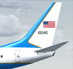
PMDG's excellent 737-700WL NGX painted in US Air Force C-40B Special Mission Aircraft colors. The PMDG NGX base pack AND 600-700 expansion pack are required for use.
The C-40B is a special-mission aircraft that provides airlift with an office-in-the- sky environment for U.S. combatant commanders and other senior government officials. Built for the U.S. Air Force, the 737-700 aircraft is equipped with equipment and capabilities that support a rapid response for global missions. C-40Bs are equipped with the Connexion by Boeing system, providing secure in-flight broadband connectivity -- data/video transmit and receive capability -- to enhance communications, productivity and security.
| Filename: | US_Air_Force_Boeing_737700WL__C40B_Special_Mission.zip |
| License: | Freeware |
| Added: | 5th November 2011, 20:05:43 |
| Downloads: | 2,792 |
| Author: | Chris Hicks |
| Size: | 12.51 MB |
| Category: Flight Simulator X - AI Flight Plans | |
| Garuda Indonesia - Summer 2019 |
|
Images related to this file:
File Description:

Current flight plan of Garuda Indonesia for summer 2019.
Founded in 1947 as KLM Interinsulair Bedrijf, the airline is now a major airline and the 20th member of the global airline alliance SkyTeam. It is the second largest airline of Indonesia after Lion Air and it operates scheduled flights to a number of destinations in Southeast Asia, East Asia, South Asia, the Middle East, Australia and Europe from its main hub in Jakarta, Soekarno–Hatta International Airport, as well as services to Australia and Asia from Ngurah Rai International Airport (Bali) and a large number of domestic flights from both Sultan Hasanuddin International Airport (Makassar) and Kualanamu International Airport (Medan).
| Filename: | Garuda_Indonesia__Summer_2019.zip |
| License: | Freeware |
| Added: | 17th July 2019, 16:30:43 |
| Downloads: | 502 |
| Author: | Frank Drebing |
| Size: | 48.27 KB |
| Category: Flight Simulator 2004 - Gauges | |
| Simulated Aircraft Bubble Sextant Chart (addon) |
|
File Description:
This is an add-on to the "dc3_bbsx.zip" Simulated Aircraft Bubble Sextant Gauge. While the simulated sextant determines the elevation to the star, it requires drawing lines of position on a chart to ascertain the latitude and longitude of the fix. The Global Navigation Charts (GNC) at scale 5,000,000:1 are suitable but not generally available for this purpose. This gauge simulates small sections of the proper chart, and automatically places the LOP from the sextant on the chart in the proper orientation. It includes installation and operating instructions, and an example flight description. Install the "dc3_bbsx.zip" first, if it hasn't been installed already.
| Filename: | Simulated_Aircraft_Bubble_Sextant_Chart_addon.zip |
| License: | Freeware, limited distribution |
| Added: | 17th March 2008, 04:15:43 |
| Downloads: | 1,183 |
| Author: | Dave Bitzer, Mark Beaumont |
| Size: | 907.27 KB |
| Category: Flight Simulator 2004 - Scenery Design | |
| Autotrees (automatic autogen file creation) beta v0.1 |
|
File Description:
Autotrees was created to automatically write any number of autogen files. It will only produce files containing trees, and I can't see a way to produce buildings the same way. It was written using UK VFR Photographic Scenery as a testbed, but should work with any photoreal ground textures. The accuracy of the output is very much dependant on the quality of the texture files used. The included jpegs are all "untouched" taken after a couple of seconds running Autotrees.
Autotrees can produce over 120 files per minute on an AMD 2.0 Ghz computer. Thats over a million trees an hour; how's that for global offsetting!
| Filename: | Autotrees_automatic_autogen_file_creation_beta_v01.zip |
| License: | Freeware, limited distribution |
| Added: | 2nd November 2007, 23:35:34 |
| Downloads: | 3,326 |
| Author: | David J Griffiths |
| Size: | 442.33 KB |
| Category: Flight Simulator X - AFCAD Files | |
| Guntersville Municipal Airport 8A1 |
|
File Description:
Guntersville Municipal Airport 8A1, also known as Joe Starnes Field, is an airport located three miles northeast of Guntersville, Alabama. The scenery adds the new runway 7-25 and closes the old runway 3-21. It also adds the water runway 6W-24W, and the new tarmac with a small amount of hangers. The buildings are placed as close to real world locations as I could get using Google Earth. Only generic FSX objects were used for ease of distribution. The file has been tested with Ultimate terrain and MegaSceneryEarth Alabama can be edited with ADE
| Filename: | Guntersville_Municipal_Airport_8A1.zip |
| License: | Freeware |
| Added: | 6th July 2017, 18:32:00 |
| Downloads: | 91 |
| Author: | Brad Banister |
| Size: | 5.94 KB |
| Category: Flight Simulator 2004 - AFCAD Files | |
| Cancún International Airport, Cancún, Quintana Roo, México (MMUN/CUN) |
|
File Description:
AFCAD for the beautiful freeware Cancun International Airport (MMUN) scenery by Henry Carcamo (see "cancun_2005.zip"). The original file comes with no AFCAD. This one is 100 % custom built from scratch. Very detailed 2D layout all over the airport to precisely match every building and equipement. All gates are here for airlines, general aviation and cargo aircraft. It works great with "Ultimate Trafic" (payware) and "AI Mexico 2005 SP4" (freeware) to create a heavy AI trafic. Your virtual Cancun airport will be as busy as in real life. See read me for details. Sun cream is not included.
| Filename: | Cancn_International_Airport_Cancn_Quintana_Roo_Mxi.zip |
| License: | Freeware |
| Added: | 23rd October 2006, 17:40:49 |
| Downloads: | 2,614 |
| Author: | Guy-Hubert Bbourdelle |
| Size: | 1011.69 KB |
© 2001-2026 AVSIM Online
All Rights Reserved
Privacy Policy |