
Where Flight Simulation Enthusiasts Gather from Around the World!
AVSIM Library - Search Results

| Category: Flight Simulator X - Scenery | |
| NY3C - Taylor Field - Hammondsport, New York (Fictional ICAO) |

|
Images related to this file:
File Description:
The airport named Taylor Field (on 1970's sectional charts) is a small 1800' strip not shown in the stock FSX list of airports. There is no ICAO code or other designator I could find with extensive research. I used my own code of NY3C.
This is a part reality part historic scenery as it represents the modern day airport, the Glenn Curtiss Museum, and adjacent to the Airport a facsimile of the original horse racetrack that was used by Glenn Curtiss to fly his June Bug on July 4th 1908. It is a close As I can determine to the original spot using archival photos and conversations with the Director of the Curtiss Museum, Traff Doherty. Extensive use of new land class is also employed to give a better representation of the geographic area.
This will work with FSX stock scenery, but is designed with UTX (Flight One Software) in mind. It will work with ORBX Global and Global Vector as well. With these latter two there may be some missing roads but it won't affect the scenery.
| Filename: | NY3C__Taylor_Field__Hammondsport_New_York_Fictiona.zip |
| License: | Freeware |
| Added: | 24th July 2014, 07:46:29 |
| Downloads: | 343 |
| Author: | Jon Davidson |
| Size: | 9.79 MB |
| Category: Flight Simulator 2004 - Miscellaneous Files | |
| ActiveSky Weather Adventures Vol. 2 - Fly the AT! |
|
File Description:
ActiveSky Weather Adventures Vol. 2 - Fly the AT! (Includes updated Vol. 1 - Winter's End) ***In addition to archives for AS2k4 users, saved flights with AS2k4 processed weather are included so people who don't own ActiveSky can fully enjoy these adventures and get a taste of what ActiveSky 2k4 has to offer! * Includes TWO Volumes of Weather Adventures * Volume 2 - Fly the AT! - Ten flights take you from Maine to Georgia along route of the Appalachian Trail - features three days of real-weather as a slow front approaches from the west - can YOU make it to Georgia before the thunder rolls in? * Volume 1 includes 10 flights highlighting weather phenomena such as a tornado outbreak in Texas and Oklahoma, a New England "nor'easter", and a massive upper-level low occupying the plains states! ***The ASWxAd-Kneeboard!*** A modification to FS9's kneeboard which allows viewing of original material describing these flights, radar and satellite loops, and annotated sectionals depicting flight plans and the AT! * This is the Automatic Installer version. A manual install is also available - ASAS2MAN.zip * Previous version had nearly 2000 downloads!
| Filename: | ActiveSky_Weather_Adventures_Vol_2__Fly_the_AT.zip |
| License: | Freeware, limited distribution |
| Added: | 4th June 2004, 14:14:58 |
| Downloads: | 2,797 |
| Author: | Scott Gridley |
| Size: | 22.04 MB |
| Category: Flight Simulator 2004 - Scenery | |
| Shea Field CSF7, Casselman Ontario Canada |
|
Images related to this file:
File Description:
Shea Field is a recently-licensed privately-owned grass airfield in Ontario, 25 miles southeast of ottawa, and south of Highway 417. When I visited I was greeeted by the horse, peering around the end of it's stable shed at the corner of apron and runway. I walked over to the house and rang the doorbell and the dog said hello and that exhausted all social contact. The hangar is large but I have no idea what is inside. There was one plane parked on the apron with a skirt of uncut grass so presumably it hasn't flown for a few months. It was a Citabria in what looked like good condition; I don't have a Citabria to park there so I put a Cub. My favourite building is the old barn, leaning to one side as if seeking support for an elbow. To the north there are some farm sheds and grain silos, and to the northwest a tall mast; avoid it. To find the field without a gps follow the 417 and look for the tall mast just west of a major highway wiggle.
| Filename: | Shea_Field_CSF7_Casselman_Ontario_Canada.zip |
| License: | Freeware, limited distribution |
| Added: | 5th August 2012, 13:35:12 |
| Downloads: | 214 |
| Author: | Roger Wensley |
| Size: | 2.62 MB |
| Category: Flight Simulator X - Missions | |
| Battle of Midway 1942 V3.00 |
|
Images related to this file:
File Description:
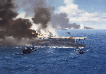
Just after having passed the Aviation Cadet Program and the E base (Elimination base), The first month we spent our time flying the primary trainers or N3N's better known as "Yellow Perils." Transferred to Wheeler air base (Honolulu) Its the first time that we see the new Horse of Battle of the Navy, the Douglass Sbd3 Dauntless, It was a beautiful plane for is time!. two mount later we receive our first instruction of the war, rejoining the U.S.S Yorktown. Here five exiting mission that will return you back in the skin of a couragous US NAVY Pilots or a IJN pilots. Make your flight plan, Check the wind and Calculate the wind drift and flight time whit your "E6b" navigation tool and wind tool in board of your plane. and prey to come back alive !. In this old time, all was made by hands. Good luck !. Here some new feature of Fsx Midway 1942 Mission v3.00: "Dummy carrier" replaced by Wonderful Yanco San I.J.N and U.S carrier ! two new exiting mission added, "Attack on Midway" and "First mission rejoining U.S.S Yorktown" Now you will fly accompanied by 2 ai wing man.
| Filename: | Battle_of_Midway_1942_V300.zip |
| License: | Freeware |
| Added: | 28th December 2011, 19:59:37 |
| Downloads: | 1,819 |
| Author: | Ronald Dandurand |
| Size: | 26.61 MB |
| Category: Flight Simulator 2004 - Scenery | |
| Chilko Lake CAG3 & Scum Lake CAW3 in British Columbia Canada |
|
Images related to this file:
File Description:
Chilko Lake and Scum Lake are both on the eastern side of the Coast Mountains of British Columbia. Chilko Lake CAG3 is around 30 miles south of Puntzi Mountain and at the northern end of the lake, serving Tsylos Park Lodge, which caters for trekking, horse riding, mountain biking, fishing etc. The runway is 3,200 feet of gravel aligned 18-36 and unlit, at 3,850 feet ASL (above sea level). Scum Lake is around 30 miles southeast of Puntzi Mountain and 25 miles northeast of Chilko Lake. Don't ask me about the name. The airstrip appears to serve a small village and is noted as "private", so perhaps also a lodge operation. The runway is 3,500 feet of gravel aligned 03-21, unlit and at 3,921 feet ASL. I have posted these as a separate scenery, but I suggest that you just add it to your previously created "BC airfields" and avoid the inevitable doubling up of common textures etc. Plus that way you will have just one FS9 library post to do and new airfields will not need yet another posting. Up to you. If you find a defect, email me.
| Filename: | Chilko_Lake_CAG3__Scum_Lake_CAW3_in_British_Columb.zip |
| License: | Freeware, limited distribution |
| Added: | 21st November 2020, 18:24:29 |
| Downloads: | 114 |
| Author: | Roger Wensley |
| Size: | 11.85 MB |
| Category: Flight Simulator X - Missions | |
| Flight to Area 61 |
|
File Description:
Captain Igor Kringbrinsky of the "Special Air Service" will be piloting flight XX-C4 to " Special Area-61"
better known to pilots as " No-whereland".
As usual he is being moved to the base at the Ust-Kamenogorsk Airport (UASK) three days before the
flight. Using an old ANT-2 he will carry electronic supplies(????) and will also pickup on the way to the
different locations (To be known only before the flight) special personnel that work in these places and
who are coming out for vacations.
As co-pilot you will have to check the plane before the flight and since on this flight you are to be rated,
previous to becoming pilot-in-command for future flights, you will do all take offs and landings.---Carefully
study the maps given to you for the " secret" locations you will land before you reach Area 61.
These "locations" may be on "Roadways", mountains, valleys and even large airports-----
Sorry to say, the Weather this time of the year is "stormy and rain, thunder and high winds may be
expected....This is a hard Mission.
| Filename: | Flight_to_Area_61.zip |
| License: | Freeware, limited distribution |
| Added: | 21st April 2008, 09:42:55 |
| Downloads: | 2,853 |
| Author: | Gera Godoy Canova |
| Size: | 5.93 MB |
| Category: Flight Simulator 2004 - Miscellaneous Files | |
| ActiveSky Weather Adventures Vol. 2 - Fly the AT! (Manual install) |
|
File Description:
ActiveSky Weather Adventures Vol. 2 - Fly the AT! (Includes updated Vol. 1 - Winter's End) ***In addition to archives for AS2k4 users, saved flights with AS2k4 processed weather are included so people who don't own ActiveSky can fully enjoy these adventures and get a taste of what ActiveSky 2k4 has to offer! * Includes TWO Volumes of Weather Adventures * Volume 2 - Fly the AT! - Ten flights take you from Maine to Georgia along route of the Appalachian Trail - features three days of real-weather as a slow front approaches from the west - can YOU make it to Georgia before the thunder rolls in? * Volume 1 includes 10 flights highlighting weather phenomena such as a tornado outbreak in Texas and Oklahoma, a New England "nor'easter", and a massive upper-level low occupying the plains states! ***The ASWxAd-Kneeboard!*** A modification to FS9's kneeboard which allows viewing of original material describing these flights, radar and satellite loops, and annotated sectionals depicting flight plans and the AT! * Two versions available: This is the Manual Install. An automatic installer is also available - ASAD2INS.zip * Previous version had nearly 2000 downloads!
| Filename: | ActiveSky_Weather_Adventures_Vol_2__Fly_the_AT_Man.zip |
| License: | Freeware, limited distribution |
| Added: | 4th June 2004, 14:18:50 |
| Downloads: | 1,503 |
| Author: | Scott Gridley |
| Size: | 23.88 MB |
| Category: Flight Simulator 2004 - Scenery | |
| CYGQ - Geraldton - Northern Ontario, Canada * Updated * |
|
Images related to this file:
File Description:
This is my last scenery post; read the text note in the zip. This greatly modifies my previous (2009) post of Geraldton, and has more purpose-made buildings. The new version is stand-alone and does not require you to have previously installed Geraldton; it interacts with Dryden and Sioux Lookout for AI flights. Geraldton is in northern Ontario, 70 miles northeast of Thunder Bay and 50 miles east of Lake Nipigon. The town is on the northern shore of Kenogamisis Lake and strung out northwards to the east-west railway line. The population is around 2,400 and the origins are in mining. The airport is a further 3 miles or so north, just south of Hutchison Lake. CYGQ has just over 5,000' of asphalt aligned 08-26; I think there used to be a second runway in a similar arrangement to the one at Dryden, but that was long ago. At the eastern end of the runway there are hangars that turn their back on an irregularly-shaped and seemingly unplanned apron; this is because it was unplanned. There was a large addition made so that fire fighting CL 415 planes could be parked there in the summer, adjacent to tanks containing foam and chemical additivies. The AI (available with my Sioux Lookout and Dryden posts) includes CL 415 flights.
| Filename: | CYGQ__Geraldton__Northern_Ontario_Canada___Updated.zip |
| License: | Freeware, limited distribution |
| Added: | 23rd March 2013, 10:55:04 |
| Downloads: | 425 |
| Author: | Roger Wensley |
| Size: | 4.26 MB |
| Category: Flight Simulator 2004 - AFCAD Files | |
| Airports used by MATVA |
|
File Description:
The MATVA Group offer you another package of Af2 files to replace the default ones for those airfields they visit, they do not have allocated gates. The 55 airfields in this package are in: Mongolia; (ZMUB) Ulaanbaatar, (ZMBN) Bulgan, (ZMMN) Moron, (ZMBH) Bayanhongor, (ZMAT) Altay, (ZMUL) Olgiy and (ZMCD) Choybalsan. Canada; (CYOA) Ekati, (CYHY) Hay River, (CYQT) Thunder Bay and (CYZF) Yellowknife. China; (ZHCC) Zhengzhou, (ZBHH) Hohhot and (ZHHH) Wuhan. Japan (RJNK) Komatsu and (RJOM) Matsuyama. S. Korea; (RKJJ) Gwangju, (RKNN) Gangneung , (RKNY) Yangyang, (RKPK) Pusan, (RKPU) Ulsan, (RKSS) Seoul/Gimpo and (RKTN) Daegu. Russia; (UIBB) Bratsk, (ULAA) Arkhangel'sk, (UMMS) Minsk2, (UNOO) Omsk, (URWA) Astrakhan, (URWW) Volgograd, (USSS) Yekaterinburg, (UUDD) Moscow/Domededovo, (UWGG) Nizhny Novgorod and (UWWW) Samara. (UKBB) Kiev, Ukraine. (ZKPY) Pyongyang, N. Korea. (ROAH) Naha, Okinawa. (RPVM) Cebu, Philippines. (EETN) Talinn, Estonia. (EGHH) Bournemouth, UK. (EVRA) Riga(LKPR) Prague. (OOMS) Muscat, Oman. (PTRO) Koror, Micronesia. (SLLP) La Paz, Bolivia. (VGZR) Dhaka, Bangladesh. (VYYY) Yangon, Myanmar. (WBSB) Brunei. (LIBD) Bari, Italy. (ESGG) Goteburg, Sweden. Also included are reworks of our previously released (EGPE) Inverness, (EIDW) Dublin, (OIII) Tehran, (ZSPD) Shanghai, (ULLI) St. Petersburg, and (SVMI) Maiquetia, Venezuela. These AFCADS are in no way intended to resemble their real world counterparts. They have been created to allow AI and flyable aircraft to do their thing, any problems get in touch at www.matva.org.uk :O) enjoy!!!!
| Filename: | Airports_used_by_MATVA.zip |
| License: | Freeware, limited distribution |
| Added: | 3rd January 2007, 00:59:49 |
| Downloads: | 8,578 |
| Author: | Louie Maclennan MATVA |
| Size: | 232.02 KB |
| Category: Microsoft Flight Simulator (2020) - Scenery Design | |
| MSFS 2020 object library with 200+ models ranging from towers hangars to cones (v10 12 extra models) |
|
Images related to this file:
File Description:
Object libraries for scenery developers (version 10 - improvements on curved surfaces + 10 lights(improved) + 3 windsocks + 3 animals + 5 animated people + 10 fuel_area +stable +fire_tower + 28 new fences + church + sheds). All objects in these libraries will be used in my own sceneries and the result of 100s hrs of effort. All objects from the real world. All objects use LOD (Level Of Detail) to keep frame rates high. Final long distance models have a large triangle added below ground to stop them disappearing in the distance. PBR materials used extensively. Included are 2 PDF files with photos of every object to make selection easy. Republish these files in any freeware scenery if required. READ "read me library instructions" before using.
---------------library1v10-cbj
Cones x4 Gables x3
Church x1
Fences (10 types farm chainlink x4 mesh x2 horse hand-rail paling cattle_grid) x94
Flag pole x1
Fuel_Signs_ x6
Fuel_area_pipes x2
Gas (petrol) station x3
Gliders x4
Glider trailers x4
Grain storage hoppers silos x 4
Power poles x2
Rail platforms station x5
Rail locomotive passenger_carriage grain_hoppers x5
Tower_forest_observation
Towers_radio x6
Weather station small x4
Windsock x3 Windsock-light x1
-------------library2v10-cbj
Animals - Cows x2 Sheep
Grain bunkers - large piles of grain covered with canvas x5
Hangars small airfield x15
Medical transfer station (building) x2
Obstacle-light x10
People x5 Men Women
Pivot irrigator x3
Sheds x10
Shelters x2
Terminals - small airfield x12
Water tanks x3
Towers water x4
Tractors farm x3
Water tanks x3
| Filename: | MSFS_2020_object_library_with_200_models_ranging_f.zip |
| License: | Freeware |
| Added: | 6th March 2022, 19:34:52 |
| Downloads: | 391 |
| Author: | COLIN JEFFERY |
| Size: | 198.25 MB |
© 2001-2026 AVSIM Online
All Rights Reserved
Privacy Policy |