
Where Flight Simulation Enthusiasts Gather from Around the World!
AVSIM Library - Search Results

| Category: Flight Simulator X - Aircraft Repaints, Textures and Modifications | |
| North American P-51D Mustang "Boo-Man Choo" (N51MV) |

|
Images related to this file:
File Description:

A repaint only for the payware Warbirdsim product 'Mustang Tales'. This repaint depicts the restored P-51D-25-NT 45-11391, "Boo-Man Choo", registered N51MV. This aircraft has a long civilian history, having been first registered with the FAA in 1963. In the 1990's, this aircraft became a popular sight when owned by Wally Sanders and painted as "Nervous Energy IV", and could sometimes be seen flown by the late, great Jeff Ethell. In the years since, the aircraft has passed through several owners, though the same over-all paint scheme has remained. In 2005, the aircraft's name was changed to "Luscious Lisa". In 2008, not long after having switched hands, the aircraft was damaged in a hard landing. For the next four years the aircraft was repaired and rebuilt, flying again in May 2012. The aircraft's most recent owner is Col. Ray Hofman, who now bases the aircraft in Midland, TX. The aircraft is now named "Boo-Man Choo", which is derived from the nickname of Col. Hofman's son, "Boo-Man". The nose art was inspired by the nurse character from the animated cartoon Animaniacs. This repaint features new bump maps, wheel well, gun bay, and cockpit textures.
| Filename: | North_American_P51D_Mustang_BooMan_Choo_N51MV.zip |
| License: | Freeware |
| Added: | 17th April 2013, 06:21:24 |
| Downloads: | 190 |
| Author: | John Terrell |
| Size: | 27.52 MB |
| Category: Prepar3D V1-4 - AI Aircraft | |
| AI Mexicana de Aviacion Aig Boeing 757-200 PW Fleet Pack |
|
Images related to this file:
File Description:

This is the Third Oldest Airline in the world, the Second Oldest Airline in Latin America, and the First Oldest Airline in Mexico, Mexicana Airlines (Mexicana de Aviacion), this is the Boeing 757-2Q8 & Boeing 757-230 Pratt & Whitney Engines the pack have the next registrations: N380RM (With Thin Logo included), N762MX, N763MX, N765MX (With Thin Logo included), XA-TRA, more later will upload the Older Liveries, the most popular and old Mexicana´s livery, (1997-2005). For the 100th Anniversary I´ll upload all the fleet, since 1940´s with the DC-2 to the last fleet that had when it flies, the Mark and Airline still exists, BUT It doesn´t fly since 2011.NOTICE!! The files are divided in 2 parts for space to uploaded in the websites and don´t have the Targa textures, the full files with Targa are in my website if you want them full. The model is Alpha India Group (AIG) Boeing 757-200 PW Basepack. This is my website: https://el-mundo-de-los-aviones-ai-traffic.jimdosite.com. I you hope you enjoy it!.
| Filename: | AI_Mexicana_de_Aviacion_Aig_Boeing_757200_PW_Fleet.zip |
| License: | Freeware |
| Added: | 27th May 2025, 22:04:08 |
| Downloads: | 28 |
| Author: | Jesus Gibran Soriano Solleiro |
| Size: | 32.64 MB |
| Category: Flight Simulator X - Scenery | |
| ENRA - Mo I Rana Rossvoll Airport - Nordland, Norway |
|
Images related to this file:
File Description:
The Mo i Rana airport, Rossvoll is a North Norwegian airport in the county of Nordland. It is located about ten kilometers northeast of the city Mo i Rana. Operator of the airport is the Norwegian state-owned company Avinor.
The Mo i Rana Airport is currently served only by the Norwegian regional airline Wideroe. Scheduled flights go to an from Bodo, Bronnoysund, Mosjoen, Rorvik, Sandnessjoen and Trondheim.
The FSX scenery:
The environment of the airport is adapted by new landclasses.
The airport has a photo background in two variants, covering all four seasons of spring, summer, autumn and winter.
The buildings in this scenery come from the fantastic XPlane scenery of Bert alias"almosquito" who kindly gave me the permission to convert them for my FSX scenery.
But there are also some objects taken from two very popular freeware libraries.
If these libraries are not installed, several objects are not visible!
The following libraries are used:
1. FS-Piloten_Objektlibrary:
http://www.fs-piloten.de/thread.php?threadid=1063
2. FSX_FlightPortLib
http://www.flightport.de/libraries/flightport-library/
Basically, libraries should be well integrated into the hierarchy of the Scenery.cfg, even below the Add-On-scenery because the Library objects otherwise may not be found by FSX.
| Filename: | ENRA__Mo_I_Rana_Rossvoll_Airport__Nordland_Norway.zip |
| License: | Freeware |
| Added: | 1st August 2015, 21:40:11 |
| Downloads: | 1,514 |
| Author: | Wolfgang Allers |
| Size: | 9.44 MB |
| Category: Flight Simulator X - Aircraft Repaints, Textures and Modifications | |
| "Fantasy of Flight" AT-6 Texan (N3931Y) |
|
Images related to this file:
File Description:
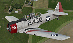
This is a repaint for the payware A2A Simulations AT-6 Texan. This repaint depicts AT-6D/AT-6G 49-3311, registered as N3931Y, which is owned/operated by Kermit Weeks at "Fantasy of Flight" in Polk City, FL. This aircraft was originally manufactured as an AT-6D in WWII for the USAAF, but was rebuilt to AT-6G standard in 1949 for the USAF. The aircraft served in the Spanish AF as a "Caza 6", C.6-167, from around 1962 all the way until 1982, serving as both a trainer and a frontline ground support aircraft, with machine guns mounted in the wings and rocket launchers under the wings. Imported into the US in the 80's, and flying on the civil register, the aircraft is painted as a tribute to the Women Airforce Service Pilots (WASP), with the markings of Avenger Field in Sweetwater, Texas, where they trained. The WASP insignia "Fifinella" is applied to the cowling, which was designed by Disney during the war. This aircraft is one of those which have been covered by Kermit Weeks in his popular "Kermie Cam" flight video series on Youtube. The repaint was created using the A2A product paintkit.
| Filename: | Fantasy_of_Flight_AT6_Texan_N3931Y.zip |
| License: | Freeware |
| Added: | 2nd April 2016, 11:43:15 |
| Downloads: | 266 |
| Author: | John Terrell |
| Size: | 33.24 MB |
| Category: Flight Simulator X - Scenery | |
| RNAS Twatt (HMS Tern) |
|
File Description:
Opened on the 1 April 1941 RNAS (HMS Tern) was used throughout the second world war by various Sqns of the Royal Navy undergoing training.
The station had 4 concrete runways with various hangers and the usual building associated with a military base. It was also the first unit in the UK to experience a helicopter crash when a Sikorsky helicopter getting ready for take off; hit a parked Blenheim.
The UK and Iceland where involved in what was called the cod wars in the early 1970s, and NATO was concerned that it would have to remove its bases from Iceland should the dispute escalate between the 2 countries and there was talk of Twatt becoming a NATO base. However, this did not happen and the idea was dropped.
There was also talk of the unit becoming a base for helicopters supporting the oil industry, however, as a result of the drop in oil prices during the 80s that idea was also dropped.
Most of the airfield has been returned to farming now with only the unique Control Tower and a handful of other building remaining.
NB: For more detailed history of this unit go to:-
https://canmore.org.uk/site/81752/twatt-airfield
| Filename: | RNAS_Twatt_HMS_Tern.zip |
| License: | Freeware |
| Added: | 30th January 2017, 02:56:37 |
| Downloads: | 143 |
| Author: | Terry Boissel |
| Size: | 18.84 MB |
| Category: X-Plane - Original Aircraft | |
| F/A18 Hornet |
|
File Description:
The F/A-18 Hornet is an all-weather aircraft used as an attack aircraft as well as a fighter. It was designed to replace both the A-7 Corsair in the light ground attack role, and the F-4 Phantom which operated in both the air defense and ground attack roles. It compliments the F-14 Tomcat and can be operated from forward airstrips for the U.S. Marine Corps. In the fighter mode, the F/A-18 is used primarily as a fighter escort and for fleet air defense; in the attack mode, it is used for force projection, interdiction and close and deep air support. The F/A-18 currently equips the majority of Navy and Marine fighter-attack squadrons and will ultimately replace the F-14 Tomcat as it has the F-4 Phantom, the A-4 Skyhawk and the A-7 Corsair II. The Blue Angels flight demonstration team has used the F/A-18 since 1987. The final Hornet to be built was rolled out of Boeing's facility at Patuxent River, Maryland, in August 2000. Over 1,400 Hornets were built and over 1,200 are now flying in fifty-five active duty, reserve and test squadrons, as well as in seven foreign countries.
| Filename: | FA18_Hornet.zip |
| License: | Freeware |
| Added: | 18th March 2003, 02:00:44 |
| Downloads: | 1,784 |
| Author: | Robert App |
| Size: | 687.47 KB |
| Category: Prepar3D V1-4 - Scenery | |
| ENRA - Mo I Rana Rossvoll Airport - Nordland, Norway |
|
Images related to this file:
File Description: The Mo i Rana airport, Rossvoll is a North Norwegian airport in the county of Nordland. It is located about ten kilometers northeast of the city Mo i Rana. Operator of the airport is the Norwegian state-owned company Avinor. The Mo i Rana Airport is currently served only by the Norwegian regional airline Wideroe. Scheduled flights go to an from Bodo, Bronnoysund, Mosjoen, Rorvik, Sandnessjoen and Trondheim. The P3D scenery is a partly rework of my FSX-ENRA scenery: Especially the apron lights are made completely new.
The environment of the airport is adapted by new landclasses. The airport has a photo background in two variants, covering all four seasons of spring,summer, autumn and winter. The buildings in this scenery come from the fantastic XPlane scenery of Bert alias "almosquito" who kindly gave me the permission to convert them for my FSX /P3D scenery. But there are also some objects taken from two very popular freeware libraries. If these libraries are not installed, several objects are not visible! Please have a look to the readme_enra.txt. The screenshots are taken from the FSX version. But the P3D version looks quite similar.
| Filename: | ENRA__Mo_I_Rana_Rossvoll_Airport__Nordland_Norway.zip |
| License: | Freeware |
| Added: | 2nd April 2019, 18:48:29 |
| Downloads: | 544 |
| Author: | Wolfgang Allers |
| Size: | 155.53 MB |
| Category: Flight Simulator X - AFCAD Files | |
| PAKT - Ketchikan airport - Ketchikan, Alaska - USA |
|
Images related to this file:
File Description:
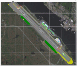
This AFCAD requires payware "Ultimate Terrain Alaska X"!! It will not work without it as it is built on the underlying terrain features and the included file "PAKT_AP.BGL" which has to be renamed or moved to a folder outside the FSX terrain environment. The original file included some errors which I tried to correct. This patch is published with permission.
Changes: The apron layout is corrected including now taxiway "C" leading to GA parking. The pavement has been changed to asphalt as it appears to be when taking aerial pictures as template. The runway got the proper overruns at both sides and the position of the ILS glideslope and localizer has been corrected as well as the DME. The layout of the airport building arrangement including the tower should be now closer to the real world and I added a working jetway. However, I used FSX default objects. As I was dependent on quite rare layout information I just tried to adjust the taxi paths and parking spots probably closer to the reality than before but I did not put any effort to name the parking spots like in real life nor did I take care for taxi signs (only the runway entries got such).
| Filename: | PAKT__Ketchikan_airport__Ketchikan_Alaska__USA.zip |
| License: | Check within download |
| Added: | 25th May 2013, 19:40:38 |
| Downloads: | 440 |
| Author: | Axel Birsul |
| Size: | 1.28 MB |
| Category: Flight Simulator 2004 - Scenery | |
| 9A8 - Ugashik, PAII - Egegik, AK96 - Bartletts, AK36 - Coffee Point , Alaska, USA |
|
Images related to this file:
File Description:
All four of these depend heavily on fishing but two of them only spring into existance during the salmon catching-and-canning season. Grant Air run scheduled flights to the two permanent settlements, and there are irregular scheduled flights and charters to the others according to demand. Ugashik is a permanent settlement 60 miles northeast of Port Heiden, stretched out along the east bank of the Ugashik River. There are two canneries, one old and collapsing and the other newer and functioning. The population is given as 12, though during the season this increases significantly. The (newer) airfield is at the northern end of the village with a gravel runway 3,500 feet long aligned 06-24. Egegik is the second permanent settlement, 45 miles north of Ugashik and 40 miles southwest of King Salmon, on the east bank of the Egegik River. The town is on a corner of land, with a population of around 110 and two operating canneries. The airport is a mile and a half south of the town with two gravel runways, 12-30 at just under 5,600 feet and 03-21 with 1,500 feet; both are lit. On the other side of the Egegik River are more canneries and two airfields, both of which have two runways but are otherwise entirely without facilities or luxuries such as lights. They are called Bartletts (named for the cannery it serves) and Coffee Point (named for the location). The shacks of the seasonal fishermen are strung out along the coast and a lot of the salmon fishing is by net, laid by a small boat and later pulled ashore for emptying. Only one cannery on the west shore has a docking facility for unloading boat-caught fish.
| Filename: | 9A8__Ugashik_PAII__Egegik_AK96__Bartletts_AK36__Co.zip |
| License: | Freeware, limited distribution |
| Added: | 3rd April 2015, 18:06:49 |
| Downloads: | 1,135 |
| Author: | Roger Wensley |
| Size: | 4.98 MB |
| Category: Flight Simulator 2004 - Scenery | |
| Alaska South Slope 12; Teller K54 |
|
Images related to this file:
File Description:
There are four main northwestern Alaska towns which are serviced by Alaska Airlines, and from which local flights spread out. The northernmost is Barrow. Southwest of Barrow is Kotzebue, then Nome, and the furthest south is Bethel (not yet made). This is the fifth in a series for local flights from Nome, and it is on the coast around 55 miles east of Wales and 55 miles northwest of Nome. There are two other airfields around a large lagoon that is almost totally enclosed from the sea, and Teller is on the easten shore, just 15 miles east of Port Clarence and 5 miles southeast of Brevig Mission, both already posted. Teller has a populaton of around 230, down from the 5,000 or so in the early 1900's after the Bluestone Placer Mine struck gold. Tollef Brevik was a Lutheran missionary who was both a pastor and teacher for the Inuit in the area from 1894 onward, travelling from community to community but based in Teller, where the Teller Mission Church was later renamed the Brevig Mission. The name was later appropriated and used for the curent village of that name; he was surely very well regarded by the local population. Unusually, it is possible to drive from Nome to Teller in summer, on a dirt road. Conversely, the road that shows in FS9 to the north towards Brevig Mission (courtesy of Ultimate Terrain) does not in fact exist except in winter, when it is estabished on the snow by the tyre tracks of users. The airstrip is southeast and 2 miles by road from the main part of the village on the spit, with a gravel runway 02-25 which is 3,500 feet of gravel. The AI is the usual for this area, Bering and ERA with some GA and cargo by Everts.
| Filename: | Alaska_South_Slope_12_Teller_K54.zip |
| License: | Freeware, limited distribution |
| Added: | 25th October 2016, 21:21:14 |
| Downloads: | 235 |
| Author: | Roger Wensley |
| Size: | 2.96 MB |


© 2001-2026 AVSIM Online
All Rights Reserved
Privacy Policy |