
Where Flight Simulation Enthusiasts Gather from Around the World!
AVSIM Library - Search Results

| Category: X-Plane - Original Aircraft | |
| China Clipper Martin M-130 for X-Plane 6.40/6.51 |

|
File Description:
China Clipper or Martin M130 for X-Plane 6.40/6.51 - Built by the Martin Company for Pan American Airlines, they were known by the company as Martin Ocean Transports. Only three of these aircraft were built, the China Clipper, the Philippine Clipper and the Hawaii Clipper. To the public, China Clipper became a generic name and originally was applied to all three of the Martin M-130's in Pan Am's fleet and, later, even to the Boeing B-314's which came later. With 4-950 HP radial engines giving a cruising speed of 163 mph and with a range in excess of 3200 miles the "Clippers" were used in the pacific by Pan Am. The "China Clipper" on November 22, 1935 inaugurated the first trans-pacific postal service with 111,000 letters; it returned to San Francisco on December 6, 1935. In 1936 the Hawaii Clipper and Philippine Clipper inaugurated paying passenger service to the Philippines and Hong Kong respectively. These were the original "Clippers" for those including the Boeing B134 to follow. Look for the B134 soon for X-Plane. Just a note : since landing gear skids are used for the wing braces X-Plane thinks that the plane has landing gear and will actually place it on the ground at the airport you select, choose an airport near water and then request a seaplane takeoff or pick a location and altitude on the regional or planet map.
| Filename: | China_Clipper_Martin_M130_for_XPlane_640651.zip |
| License: | Freeware, limited distribution |
| Added: | 11th February 2003, 05:51:20 |
| Downloads: | 1,327 |
| Author: | Robert App |
| Size: | 1.13 MB |
| Category: Flight Simulator 2004 - Scenery | |
| CYKF – Kitchener / Waterloo, Ontario, Canada Version 3.0 |
|
File Description: I have now overhauled the CYKF Airport and made it the lively place it is today. I used the Canada Flight Supplement and my real life knowledge of the airport as this is where I do my flight training.
After seeing the traffic in my Southwestern Ontario addon, CYKF 2.1 looked a little bare in comparison, so added more parking and traffic. There are now 35 parking spots and 2 gates. All parking spots and gates have been assigned codes, which like the airline codes for the larger airports will tell the GA aircraft where to park. I organized the different aprons into parking areas. The Waterloo Wellington flight centre is referred to as “North” parking. There are 3 other parking areas as well as the gates. Traffic includes weekly scheduled aircraft that will fly up to the cottage or down south on the weekend etc.
• 35 parking spots, 2 gates
• Extended runway 25/07 and added the new taxiway and renamed the others
• Changed the landclass for the runway 25/07 extension
• Updated the airport in AFCAD for AI to use the runway 25/07 extension
• Added 22 AI flightplans to the 3 already there. AI will model real life training and commercial operations of the airport
• AI use proper Canadian registration codes
• Tested the files to make sure it operates correctly including AI
| Filename: | CYKF__Kitchener__Waterloo_Ontario_Canada_Version_3.zip |
| License: | Freeware, limited distribution |
| Added: | 14th November 2003, 19:39:31 |
| Downloads: | 2,750 |
| Author: | David Voogd |
| Size: | 1.06 MB |
| Category: Flight Simulator 2004 - Scenery | |
| Avon STOLPort (KWHR) |
|
File Description:
A recreation of the Avon STOLPort (ident KWHR) for MS Flight Simulator 2004, A Century of Flight. Avon was operated as an exclusive destination for Rocky Mountain Airways between (approximately) 1978 and sometime in the late 80's or early 90's. The 4,000' runway was short for the nearly 7,500' elevation, and surrounded by mountains, some towering over 6,000' above the airport elevation. To allow all weather operation, the airport eventually featured what was reported as the steepest ILS ever constructed, with a seven degree glideslope. RMA had exclusive use of the tiny STOLPort and operated it with 50-passenger De Haviland Dash 7 equipement.
Lacking the original chart, I surveyed in FS and plotted what is hopefully an accurate representation of the ILS approach, using my best understanding of TERPS - the US standard for instrument approaches. I also created an NOS-style IAP chart of this approach for the package. A text Takeoff Minimums & Procedure is also included.
AI ATC & traffic recognition of the approach will hopefully follow, but does not exist yet. In other words, you can fly this approach and see the localizer in the GPS, but AI ATC will not give you vectors to it. You'll need to follow the full procedure included on the chart.
Please see the full Readme.txt in "Flight Simulator 9\Addon Scenery\KWHR\Docs" in this zipfile for information on installation of the scenery, flying the approach, and more on the history of the Avon STOLPort.
| Filename: | Avon_STOLPort_KWHR.zip |
| License: | Freeware, limited distribution |
| Added: | 12th May 2008, 23:14:38 |
| Downloads: | 418 |
| Author: | Stephen Comer |
| Size: | 2.1 MB |
| Category: Flight Simulator X - Scenery | |
| KSNA, John Wayne-Orange County Airport |
|
Images related to this file:
File Description:

John Wayne Airport (IATA: SNA, ICAO: KSNA, FAA LID: SNA) is an airport in an unincorporated area in Orange County, California, with its mailing address in the city of Santa Ana, which is also the county seat, hence the International Air Transport Association (IATA) airport code. The main entrance to the airport is off of MacArthur Blvd in Irvine, the city that abuts the airport from the north and east. Newport Beach and Costa Mesa form the southern and western boundaries, respectively, together with a small unincorporated area along the Corona del Mar (73) Freeway. Santa Ana lies just north, not actually touching the airport directly. Originally named Orange County Airport, the county Board of Supervisors renamed it in 1979 to honor the actor John Wayne, who resided in neighboring Newport Beach and died that year. It also became the first airport to be named after an entertainer.
The main runway, at 5,701 feet (1,738 m), is one of the shortest of any major airport in the United States, resulting in most passenger aircraft operating from the airport to be no larger than the Boeing 757. However, some larger cargo aircraft, such as the FedEx A310/300, fly from SNA. Some gates are built to handle planes up to the size of a Boeing 767, which can operate with payload/fuel load restrictions. No wide-body passenger aircraft are currently in scheduled service at the airport.
| Filename: | KSNA_John_WayneOrange_County_Airport.zip |
| License: | Freeware, limited distribution |
| Added: | 11th October 2011, 08:25:20 |
| Downloads: | 11,008 |
| Author: | Mateusz Stabryla MK-Studios |
| Size: | 66.92 MB |
| Category: Flight Simulator 2004 - Scenery | |
| KSNA, John Wayne-Orange County Airport |
|
Images related to this file:
File Description:

John Wayne Airport (IATA: SNA, ICAO: KSNA, FAA LID: SNA) is an airport in an unincorporated area in Orange County, California, with its mailing address in the city of Santa Ana, which is also the county seat, hence the International Air Transport Association (IATA) airport code. The main entrance to the airport is off of MacArthur Blvd in Irvine, the city that abuts the airport from the north and east. Newport Beach and Costa Mesa form the southern and western boundaries, respectively, together with a small unincorporated area along the Corona del Mar (73) Freeway. Santa Ana lies just north, not actually touching the airport directly. Originally named Orange County Airport, the county Board of Supervisors renamed it in 1979 to honor the actor John Wayne, who resided in neighboring Newport Beach and died that year. It also became the first airport to be named after an entertainer.
The main runway, at 5,701 feet (1,738 m), is one of the shortest of any major airport in the United States, resulting in most passenger aircraft operating from the airport to be no larger than the Boeing 757. However, some larger cargo aircraft, such as the FedEx A310/300, fly from SNA. Some gates are built to handle planes up to the size of a Boeing 767, which can operate with payload/fuel load restrictions. No wide-body passenger aircraft are currently in scheduled service at the airport.
| Filename: | KSNA_John_WayneOrange_County_Airport.zip |
| License: | Freeware, limited distribution |
| Added: | 11th October 2011, 04:03:32 |
| Downloads: | 4,881 |
| Author: | Mateusz Stabryla MK-Studios |
| Size: | 59.73 MB |
| Category: Prepar3D V1-4 - Aircraft Repaints, Textures and Modifications | |
| China Airlines 1998 AI Package |
|
File Description:
China Airlines had almost completely repainted the fleet by 1998, in these flightplans there is only 1 A300s left in the old livery. China Airlines rushed the repaint of their fleet as the Taiwanese flag on the old colors was not allowed in HKG after the 1997 hand over from England making Hong Kong a Chinese Territory. As such, the old colors were gone by 1998. The 737-400s were still very much active, but were very near the end of their lives with China Airlines retired by 1999 or so. The 737-400s do some regional international routes, and also high frequency KHH-TSA flights and a few TPE-KHH flights. Only 2 747-200s left, mostly flying to HND, and the A300-600R is the backbone of the fleet with a handful of A300B4s still flying. The 747SPs all were at Mandarin by 1998. At this time, and Mandarin aircraft often subbed for China Airlines 747-400s and MD-11s using the "DYNASTY" callsign. I have included an MD-11 in Mandarin colors operating China Airlines flights, I recommend you make a separate aircraft.cfg entry for the Mandarin MD-11 aircraft with the "DYNASTY" callsign and "CAL" parking code for realism. Repaints by Ranmori Scythe for the FAIB 737-400, 747-200, 747-400, FSPX MD-11, and TFS A300B4 and A300-600R are included. As a bonus, textures are also included for the FAIB 737-800(which entered the fleet in 1999) and the old colors on the FAIB 747-400(discontinued by 1997). Feel free to use the 737-400 instead of the 737-800 if you wish. All repaints were done by the very talented Ranmori Scythe and flightplans were done by the not-so-talented Chasen Richardson. Requires mandarin_airlines_1998.zip for the Mandarin textures. Part of the 1998 Flight Simulator Project. Follow us on Facebook at facebook.com/flightsim98 and on instagram as @bayviationsim. For more Retro AI, check out the forums at: http://retroai.proboards.com/
| Filename: | China_Airlines_1998_AI_Package.zip |
| License: | Freeware, limited distribution |
| Added: | 21st November 2019, 19:18:09 |
| Downloads: | 298 |
| Author: | Ranmori Scythe, Chasen Richardson/Bayviation |
| Size: | 13.92 MB |
| Category: Flight Simulator 2004 - Scenery | |
| Dawson Creek CYDQ in British Columbia, Canada |
|
Images related to this file:
File Description:
Dawson Creek is at 2,148 feet asl just east of the Rocky Mountains, less than 10 miles west of the BC/Alberta border. The Peace River, 25 miles north of Dawson Creek, links the two sides of the Rockies, winding through peaks that reach up almost to 8,000 feet. The population grew when the Northern Alberta Railway was extended to Dawsons Creek in 1932, and grew even more more when the Alaska Highway was built in 1942 and Dawsons Creek was where it started from. The airport is just to the east of the town. The runway is 5,000 feet of wide asphalt (150 feet) aligned 06/24, lit, and with PAPI and approach lights. There is a water runway to the north of the main runway with the same alignment, separately designated as Dawson Creek CBD3. The two operate as one; traffic for both use the mandatory frequency of 122.2 and talk to one controller in one control tower. However, in FS9 the ATC for two separately designated airfields operates as if they are nowhere near each other and near misses are the result. I have put them both in un-manned tower mode so you will announce your position and intentions and select your own parking spots etc. There is in reality a lack of apron markings but I have marked the positions of both gates. The apron is not large so there is only one other apron parking spot (see the traffic cone) and most parking is either next to one of the hangars or on the grass. The aprons vary from asphalt, to concrete, onwards to gravel, and then further onwards to some gravel amid the bare dirt; I have replicated this variation as far as FS9 permits. The buildings are bespoke from photos. The AI includes Central Mountain Air with two daily scheduled flights and Northern Cariboo as one of the airlines that occasionally runs charter flights in CYDQ. There are also private GA flights, and float plane flights into and out of CBD3.
| Filename: | Dawson_Creek_CYDQ_in_British_Columbia_Canada.zip |
| License: | Freeware, limited distribution |
| Added: | 22nd November 2013, 23:31:40 |
| Downloads: | 654 |
| Author: | Roger Wensley |
| Size: | 16.65 MB |
| Category: Prepar3D V1-4 - Aircraft Repaints, Textures and Modifications | |
| PMDG 747-830 Lufthansa Star Aliance |
|
Images related to this file:
File Description:
This is the fictional Lufthansa Star Alliance Livery from the Airbus A340 for the PMDG 747-8 QOTSII
| Filename: | PMDG_747830_Lufthansa_Star_Aliance.zip |
| License: | Freeware |
| Added: | 20th December 2019, 02:58:25 |
| Downloads: | 233 |
| Author: | Tristan Arnhold |
| Size: | 16.62 MB |
| Category: Prepar3D V1-4 - Aircraft Repaints, Textures and Modifications | |
| Luxair 'Classic Livery' Boeing 737-8C9 |
|
Images related to this file:
File Description:
This is the fictional Luxair Classic Livery from the Boeing 737-200 for the PMDG 737-800NGXu SSW
| Filename: | Luxair_Classic_Livery_Boeing_7378C9.zip |
| License: | Freeware |
| Added: | 4th January 2020, 18:34:53 |
| Downloads: | 67 |
| Author: | Tristan Arnhold |
| Size: | 15.58 MB |
| Category: Flight Simulator X - Aircraft Repaints, Textures and Modifications | |
| Cessna C172R (PH-WVO) |
|
Images related to this file:
File Description:
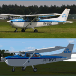
Repaint of the KLM PH-WVO for the A2A Accusim C172 Trainer. Requires the original Accusim C172 Trainer.
| Filename: | Cessna_C172R_PHWVO.zip |
| License: | Freeware |
| Added: | 13th September 2013, 23:04:34 |
| Downloads: | 348 |
| Author: | Johan Wijnands |
| Size: | 13.62 MB |


© 2001-2026 AVSIM Online
All Rights Reserved
Privacy Policy |