
Where Flight Simulation Enthusiasts Gather from Around the World!
AVSIM Library - Search Results

| Category: Flight Simulator X - Aircraft Repaints, Textures and Modifications | |
| Learner Aircraft --Cessna 172-- |

|
File Description:
This is the standard FSX Cessna 172 with a custom panel to enhance learning the principles of Flight and Navigation. Large gauges are on the panel plus digital readouts for most of the gauges so that there will be no guessing of the readings. The view over the panel is 50% larger than the default Cessna 172. Not on the panel are most of the non-flying gauges such as fuel gauges, engine instruments, engine controls, etc. The intent was to keep the panel uncluttered. Thanks to Norman Hancock and Dave Bitzer for the non-standard gauge designs, and to Tom Goodrick for the great auto-start/auto-stop flight timer and to Kyle Copeland for the fine panel Bitmap. Easy install self-extracting file. By Charles Wood.
| Filename: | Learner_Aircraft_Cessna_172.zip |
| License: | Freeware |
| Added: | 16th January 2009, 11:10:06 |
| Downloads: | 707 |
| Author: | Charles Wood |
| Size: | 1.99 MB |
| Category: Flight Simulator 2004 - Scenery | |
| Israel SRTM 90m Mesh Ver. 1.0 |
|
File Description:
Finally, VFR/CVFR pilots are able to enjoy the tall peaks of the Hermon mountain, the Golan heights and the ravines of the Western slopes of the Carmel mountains, the road to Jerusalem and the sub-sea level features of the Sea of Galilee and the famous Dead Sea.
The Negev Desert can finally show off its fascinating topography which includes, among others, the Small Crater and Ramon Crater whose features are clearly visible from space. There are many canyons, ravines, dry streams and other dramatic ground landscapes which can make a Negev Dessert VFR Expedition quite exciting. The trip could end at Eilat. Now you can see this well known touristic resort, bordered on the West and East by the tall and rugged mountains which have been among its more typical features.
| Filename: | Israel_SRTM_90m_Mesh_Ver_10.zip |
| License: | Freeware, limited distribution |
| Added: | 23rd April 2004, 12:54:03 |
| Downloads: | 12,086 |
| Author: | Alexander Lawrence |
| Size: | 7.26 MB |
| Category: Flight Simulator 2004 - Aircraft Repaints, Textures and Modifications | |
| Learner Aircraft --Cessna 172-- |
|
File Description:
This is the standard fs9 Cessna 172 with a custom panel to enhance learning the principles of Flight and Navigation. Large gauges are on the panel plus digital readouts for most of the gauges so that there will be no guessing of the readings. The view over the panel is 50% larger than the default Cessna 172. Not on the panel are most of the non-flying gauges such as fuel gauges, engine instruments, engine controls, etc. The intent was to keep the panel uncluttered. Thanks to Norman Hancock and Dave Bitzer for the non-standard gauge designs, and to Tom Goodrick for the great auto-start/auto-stop flight timer and to Kyle Copeland for the fine panel Bitmap. Easy install self-extracting file. By Charles Wood.
| Filename: | Learner_Aircraft_Cessna_172.zip |
| License: | Freeware |
| Added: | 14th January 2009, 14:53:43 |
| Downloads: | 2,158 |
| Author: | Charles Wood |
| Size: | 3.96 MB |
| Category: Prepar3D V5 - AI Aircraft | |
| AI Fiscalia General de la Republica AI Malcontent Embraer ERJ-135LR XC-FGR |
|
Images related to this file:
File Description:

This is the newest government mexican aircraft for the Fiscalia General de la Republica (FGR) (Attorney General´s Office), the aircraft of this package for now is only 1 Embraer ERJ-135LR with the registrations XC-FGR, the files contain only one texture. The Attorney General of the Republic is the head of the Attorney General´s Office and the Federal Public Prosecutor's Office of the United Mexican States, an institution belonging to the Federal Government´s constitutional autonomous organism that is responsible for the investigation and prosecution of federal crimes. and operated with the Embraer ERJ-135 aircraft with capacity for 37 passengers. This is my website: https://el-mundo-de-los-aviones-ai-traffic.jimdosite.com The model is Ai Malcontent (AIM) Embraer ERJ-135 Basepack. I hope you enjoy it!
| Filename: | AI_Fiscalia_General_de_la_Republica_AI_Malcontent_Embraer_ERJ135LR_XCFGR.zip |
| License: | Freeware |
| Added: | 26th April 2025, 14:02:42 |
| Downloads: | 40 |
| Author: | Jesús Gibran Soriano Solleiro |
| Size: | 7.67 MB |
| Category: Flight Simulator 2004 - Original Aircraft | |
| Dassault-Mirage F-1 CZ |
|
File Description:
The Dassault-Mirage F-1 was developed to address the shortcomings of the Mirage III, especially the shortcomings in handling. The F-1 CZ is the fighter-striker version of the F-1. Two paint schemes are provided; the first is the camouflage version of 3 Squadron of the South African Air Force during the late 1970’s and the second the low visibility gray used by the same squadron during the 1990’s. This aircraft features full animation (control surfaces, spoilers, landing gear & canopy), a dynamic virtual cockpit, checklist and full lighting effects. A custom-designed photo-realistic panel (with xml-gauges) is also included. If you would like to fly a supersonic fighter, this it it – this jet can really reach Mach 1.2 at sea level and Mach 2.2 at high altitude.
| Filename: | DassaultMirage_F1_CZ.zip |
| License: | Freeware |
| Added: | 19th June 2004, 07:24:25 |
| Downloads: | 7,321 |
| Author: | Vasco Ferreira & Thinus Pretorius |
| Size: | 5.38 MB |
| Category: X-Plane - Scenery | |
| XP11 German Scenery EDHK 2018+ Kiel-Holtenau |
|
File Description:
The small Zip-file will include a link for scenery download, because the scenery file size is above 500 Mbyte. Just follow the link and download EDHK 2018. This is an "install and fly" version, everything you need is already included (*see info below) and I will continously update the scenery. The story, in November 2012 the German MFG5 (Marineflieger-Geschwader) was relocated to Nordholz (ETMN). This was the end of the main military use in the southern and eastern part of the airport. Because the German harbor city Kiel needs living space for their citizens, opponents of the airport tried to convince citizens and politics to close the airport and to create there living space instead. In 2018 the citizen of Kiel voted with a citizen’s decision with the result that the majority voted for the preservation of the traditional airport. Personally, I am very happy with this decision. On the area of the airport some companies are settled, their employees should be able to sleep a little better now. In addition, there will certainly be future investments in the airport due to the election results. Since the airport has been financially in the red for years, the operator of the airport, the Port of Kiel Flughafen GmbH & Co. KG has converted large areas of the airport as parking area. These parked vehicles are part of the constantly increasing cruise ship operations within Kiel, making it possible for passengers to safely park their vehicles for extended periods of time. The taxiways “A†and “D†of EDHK are no longer in operation. This was of course taken into account in my scenery. The access to this taxiway was marked as in the original by yellow "X". The taxiway lighting was also turned off there. The on-site Luftsportverein (LSV) uses above the runway 08/26 an individually marked grass runway (not official), I called it 08S/26S and it is for the winch launch of their gliders only. The size of this provisional winch runway is about 820x20m. A glider takeoff by towing aircraft is usually handled by the Runway 08/26.(*) There is no copyright infringement, since I have received all the needed permissions to use the listed objects/libraries full or in parts within my scenery, the same for the single objects or non-Library bound objects/elements. I got all these permissions in writing from each individual author/rights holder. Take the time and read the full, included descritpion, please. If you have question, ask me first!
| Filename: | XP11_German_Scenery_EDHK_2018_KielHoltenau.zip |
| License: | Freeware |
| Added: | 28th November 2018, 22:46:11 |
| Downloads: | 69 |
| Author: | Marco Moschet |
| Size: | 1.3 KB |
| Category: X-Plane - Scenery | |
| XP11 German Scenery EDHK 2018+ Kiel-Holtenau |
|
Images related to this file:
File Description:
The small Zip-file will include a link for scenery download, because the scenery file size is above 500 Mbyte. Just follow the link and download EDHK 2018. This is an "install and fly" version, everything you need is already included (*see info below) and I will continously update the scenery. The story, in November 2012 the German MFG5 (Marineflieger-Geschwader) was relocated to Nordholz (ETMN). This was the end of the main military use in the southern and eastern part of the airport. Because the German harbor city Kiel needs living space for their citizens, opponents of the airport tried to convince citizens and politics to close the airport and to create there living space instead. In 2018 the citizen of Kiel voted with a citizen’s decision with the result that the majority voted for the preservation of the traditional airport. Personally, I am very happy with this decision. On the area of the airport some companies are settled, their employees should be able to sleep a little better now. In addition, there will certainly be future investments in the airport due to the election results. Since the airport has been financially in the red for years, the operator of the airport, the Port of Kiel Flughafen GmbH & Co. KG has converted large areas of the airport as parking area. These parked vehicles are part of the constantly increasing cruise ship operations within Kiel, making it possible for passengers to safely park their vehicles for extended periods of time. The taxiways “A†and “D†of EDHK are no longer in operation. This was of course taken into account in my scenery. The access to this taxiway was marked as in the original by yellow "X". The taxiway lighting was also turned off there. The on-site Luftsportverein (LSV) uses above the runway 08/26 an individually marked grass runway (not official), I called it 08S/26S and it is for the winch launch of their gliders only. The size of this provisional winch runway is about 820x20m. A glider takeoff by towing aircraft is usually handled by the Runway 08/26.(*) There is no copyright infringement, since I have received all the needed permissions to use the listed objects/libraries full or in parts within my scenery, the same for the single objects or non-Library bound objects/elements. I got all these permissions in writing from each individual author/rights holder. Take the time and read the full, included descritpion, please. If you have question, ask me first!
| Filename: | XP11_German_Scenery_EDHK_2018_KielHoltenau.zip |
| License: | Freeware |
| Added: | 29th November 2018, 19:24:38 |
| Downloads: | 65 |
| Author: | Marco Moschet |
| Size: | 1.3 KB |
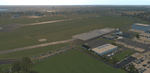
| Category: Flight Simulator 2004 - Scenery | |
| Fort Nelson CYYE in British Columbia, Canada |
|
Images related to this file:
File Description:
Fort Nelson is close to the Peace River in the northeast corner of British Columbia, around 70 miles from the northern border, 90 from the eastern border, and 80 miles east of the Rockies. The wartime construction of the Alaska Highway actually started from Fort Nelson, as there was already a road from Fort St John (which is close to Dawson Creek) north to Fort Nelson. The airfield was part of this construction effort and after the wartime ferrying of planes to Russia it was used by the US Army Air Force and then by the Canadian Air Force. Fort Nelson flourished with the oil and gas exploration of the 1950's and the following years, and this continued to grow until the collapse of the oil price in 2014.
The town of Fort Nelson became the capital of the Northern Rockies Regional District when it was founded in 2009, and as a result the official name of the Fort Nelson airport is the Northern Rockies Regional Airport. The date for this scenery is around 2016, by which time the economic fortunes of the town were in decline. Five times per day flights by Central Mountain Air were starting to be reduced in number to the current (in 2022) one per day and none on Sunday; in the AI included here there are two flights per day. The main resident users of the airport are four helicopter companies, the helicopters presumably used for maintenance trips to whatever parts of the oil and gas fields that are still in use in the surrounding area.
There are two runways, the main one is aligned 03-21, 6,400 feet long and 200 feet wide, with ILS at the southern end and PAPI at the northern. The second runway (a narrower rebuild on a previously existing runway) is aligned 07-25 and 77 feet wide, and is without any lights. These are the alignments as per the original build of FS9 and not as per the approximate 2016 date of the buildings; I had a problem at a very late stage in making this scenery which prevented me from continuing with some final details.
On YouTube there is a series of posts by Angle of Attack showing the preparation and then the flight of an old Cessna 172 from Homer to Oshkosh for the installation of modern instruments. Interesting for me as they visit or fly over airfields I have made (Homer, Merrill, Tok Junction, Burwash, Silver City, Haines Junction, Watson Lake, Fort Nelson, and Grande Prairie) but in the winter so it all looks very different.
| Filename: | Fort_Nelson_CYYE_in_British_Columbia_Canada.zip |
| License: | Freeware, limited distribution |
| Added: | 23rd January 2022, 20:11:18 |
| Downloads: | 187 |
| Author: | Roger Wensley |
| Size: | 28.35 MB |
| Category: Flight Simulator 2004 - Scenery | |
| Coal Harbour CAQ3 float base in British Columbia, Canada |
|
Images related to this file:
File Description:
This is number eight in a series of new and renovated float bases in BC. Coal Harbour is in a sheltered cove off Holberg Inlet on the northwest coast of Vancouver Island, close to the village and 10 miles southwest of the Port Hardy float base. There is 100LL fuel and oil available. Due to the deep fjords that run into Vancouver Island from the west coast Coal Harbour is actually closer to the east coast than it is to the west coast. The tortuous route in through Quatsino Sound and Rupert Sound shelters the waters of Holberg Inlet from the stormy seas of the west coast, and fishing boats take advantage of this. The floatplane dock is to the south of the large (and old) hangar, adjacent to the southern end of the fixed dock where the ramp bridge descends to the floating docks. The video makes it clearer. The AI is a further adaptation of the CF36 AI and involves Beavers and Otters as listed in the AI folder. Due to the surrounding hills there may be some interference with AI aircraft, depending on the wind direction, though I have watched succesful Beaver and Otter landings. Amid the hills there is a very large hole in the ground to the east. The village name suggests it may have been for coal but though in fact there was a coal mine, that was a much smaller and unsuccesful venture; this particular scene of enthusiastic digging was for copper, until 1996. The main claim to fame of Coal Harbour was that it was the last whaling station in North America, using the buildings that were part of the RCAF float plane patrol base during WW2. One downloader reported a texture problem with Port McNeill, to which we found a solution. As he was the only person to email me I am going to presume that nobody else had the problem.
| Filename: | Coal_Harbour_CAQ3_float_base_in_British_Columbia_C.zip |
| License: | Freeware, limited distribution |
| Added: | 25th January 2017, 00:29:05 |
| Downloads: | 225 |
| Author: | Roger Wensley |
| Size: | 7.79 MB |
| Category: Flight Simulator 2004 - Scenery | |
| Port Hardy CAW5 in British Columbia, Canada |
|
Images related to this file:
File Description:
This is the sixth in a series of new and renovated float bases in BC. Port Hardy CAW5 is in a sheltered inlet on the northeast coast of Vancouver Island, close to the town and just 6 miles northwest of the Port Hardy airport. There is fuel (both JetA and 100LL) and also oil available, and the base acts as a refuelling centre for the other float bases in the neighbourhood. The dock is one-sided as the northern side borders a shallow area that is in fact exposed at low tide, as is most of the inlet to the south of BC Packers (adjacent to the float base, to the south). The parking along the dock is maximised by backing up each plane by hand so that it is close to the one behind it; this is not possible to replicate with AI in FS9 (watch the video). Watch out for the log boom on the other side of the inlet, it is there to protect fish farm "pools". The AI involves several Beavers and Otters, as listed in the AI folder. At Port Hardy all the AI works for both landing and takeoff for all of the planes, no matter what is the wind direction. There is a pic of the Supplement Port Hardy page, showing the two take-off and landing areas plus the third area that is to be used for take-off before 7am. All of these float bases can be installed together in the same folders, with a saving in duplicate textures. So a series called BC Floats (or whatever you want to call it) or individually installed float bases; your choice. The next in the series was suposed to be Sullivan Bay, another floating marina, but I digressed to Port Hardy and Port McNeill (next to be posted). The two hotels by the nearby marina are included. One of them gave me weird problems and I gave up on achieving the correct shape.
| Filename: | Port_Hardy_CAW5_in_British_Columbia_Canada.zip |
| License: | Freeware, limited distribution |
| Added: | 19th January 2017, 15:01:45 |
| Downloads: | 201 |
| Author: | Roger Wensley |
| Size: | 8.27 MB |
© 2001-2026 AVSIM Online
All Rights Reserved
Privacy Policy |