
Where Flight Simulation Enthusiasts Gather from Around the World!
AVSIM Library - Search Results

| Category: Flight Simulator X - Scenery | |
| British Columbia Floatbases |

|
Images related to this file:
File Description:
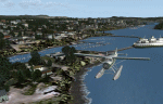
This is a collection of floatbases around the coast of British Columbia made with default scenery objects, and derived from Google Earth and the Canada Waterdrome Supplement. This scenery is designed to complement the work of others and therefore doesn't include waterdromes made by others such as Sidney Schwartz's CYYJ, Ganges Harbour and BCPNW Float Bases which covers an area around the Gulf Islands. You must have Ultimate Terrain Canada for these sceneries to work and in areas away from the immediate coast (Fraser River), a SRTM mesh for the correct elevations.
| Filename: | British_Columbia_Floatbases.zip |
| License: | Freeware |
| Added: | 16th May 2012, 14:02:09 |
| Downloads: | 1,538 |
| Author: | Chris Peschke |
| Size: | 183.32 KB |
| Category: Flight Simulator 2004 - Scenery | |
| Project Mexico Real LOD10 File 3 of 11 |
|
Images related to this file:
File Description:
Re-upload. File 3rd of 11 of a Terrain Mesh that covers the entirety of Mexican Territory and related bordering U.S., Guatemala and Belice areas, part of the "Proyecto Mexico Real" project, compiled at LOD10 (1.24 arcseconds in latitude and 1.65 arcseconds in longitude) resolution from INEGI data. Intended to enhance the virtual flying experience complementing the LOD8 and LOD9 versions compiled from the same data. Compatible backwards with Flight Simulator 2000, Flight Simulator 2002 and Combat Flight Simulator 2. Refer to the file contents about the cover area to this compressed file.
| Filename: | Project_Mexico_Real_LOD10_File_3_of_11.zip |
| License: | Check within download |
| Added: | 8th June 2010, 03:17:03 |
| Downloads: | 3,253 |
| Author: | Juan Jose Galvan Bautista |
| Size: | 73.67 MB |
| Category: Flight Simulator 2004 - Scenery | |
| Alta circling approach |
|
File Description:
The old circling approach for runway 30 at Alta, Norway (ENAT) is a challenging approach. I don't think it is used anymore, but it was still in use during the 1980:s and perhaps even into the 1990:s when SAS flew DC-9 i northern Norway. During the approach you fly a circle, following lights in the terrain and keeping track of the altitude. Included in this zip-archive are the bgl-files for the lights and the old approach plates for Alta. Recommended additional installations are Norway airports and Norway Mesh.
Happy flying!
| Filename: | Alta_circling_approach.zip |
| License: | Freeware |
| Added: | 20th May 2010, 02:48:06 |
| Downloads: | 438 |
| Author: | Krister Renard |
| Size: | 328.64 KB |
| Category: Flight Simulator 2004 - Scenery | |
| Alps LOD10 Topo Mesh - Update 1 |
|
File Description:
Patch files to remove tall spike in terrain near Salzburg at N47 44´ E13 00´ and to add the missing/distorted peaks of La Grande Moucherolle at N45 00´ E5 34´ and Mont Aiguille at N44 50' E5 33'.
Requires the full version of our Alps LOD10 mesh files, alpse_fe.zip and alpsw_fe.zip. Source data by Jonathan de Ferranti, compiled for FS by Holger Sandmann. Fully compatible with FS2002. A big thank-you to those who reported the "Salzbug" and the missing peaks in the French Alps.
| Filename: | Alps_LOD10_Topo_Mesh__Update_1.zip |
| License: | Freeware, limited distribution |
| Added: | 9th February 2006, 15:02:59 |
| Downloads: | 32,359 |
| Author: | Holger Sandmann, Jonathan de Ferranti |
| Size: | 2.57 MB |
| Category: Flight Simulator X - Scenery | |
| South America Mesh Scenery, MeshX_F3 |
|
File Description:
Mesh terrain scenery for the whole continental South America, based on SRTM 90m
dem geotiff files resampled to 76 meter of horizontal resolution (LOD 9).
The new files have improved the vertical resolution from 16m to 10m, resulting
in more details and accuracy over previous versions. There are 50 files, compatible
with FS9 and FS X, identified in a map by column letter and line number, covering the
contiguous countries and states. Boundaries: N = 0º 0' S; S = 5º 37.5' S;
E = 33º 45' W; W = 41º 15' W;
| Filename: | South_America_Mesh_Scenery_MeshX_F3.zip |
| License: | Freeware |
| Added: | 28th October 2006, 10:09:48 |
| Downloads: | 1,415 |
| Author: | Oséas Dourado and José Lôbo |
| Size: | 10.96 MB |
| Category: Prepar3D V1-4 - Scenery | |
| P3D v4.3 Aeropuerto Internacional Alejandro Velasco Astete-PERU |
|
Images related to this file:
File Description:
ONLY FOR P3D V4.3
REQUIRES ANY TERRAIN MESH
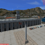
Alejandro Velasco Astete International Airport (IATA: CUZ, ICAO: SPZO) is an international airport located in the city of Cusco, in southeastern Peru. Cusco, a principal tourist attraction in Latin America, receives various domestic flights as well as some international flights. The runway is completely paved. It operates at limited capacity due to its precarious location near the city's center. Despite these limitations, the airport has consistently ranked as Peru's second most important air terminal, handling 3,209,153 national and international passengers in 2016, as reported by CORPAC.
| Filename: | P3D_v43_Aeropuerto_Internacional_Alejandro_Velasco.zip |
| License: | Freeware |
| Added: | 15th June 2019, 22:52:35 |
| Downloads: | 1,744 |
| Author: | Jhon Cristian |
| Size: | 115.91 MB |
| Category: Flight Simulator X - Scenery | |
| Algiers City PhotoTerrain Scenery X |
|
Images related to this file:
File Description:
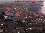
FSX Algiers City Photo Terrain by Riad GHENIM
Algiers City, DAAG, Algeria. A mediterranean city with its beautiful coasts. Beta version.
This photo terrain scenery works with Algiers Real Scenery DAAG for FSX
| Filename: | Algiers_City_PhotoTerrain_Scenery_X.zip |
| License: | Freeware |
| Added: | 3rd June 2011, 22:28:46 |
| Downloads: | 13,016 |
| Author: | Riad Ghenim |
| Size: | 25.34 MB |
| Category: Flight Simulator 2002 - Scenery | |
| Barbados & Grenadines SRTM Mesh |
|
File Description:
This is a mesh for Barbados and the Grenadines area islands made from raw SRTM 3 arc second data using SRTM to BGL, sampled to LoD 9 by default. The mesh includes part of St. Lucia, and the difference there is such that I would recommend getting some kind of mesh for St. Lucia if you intend to fly out that way. (I may make additional meshes for that reason, but I think there are other meshes available too.)
This mesh should work with FS2004, but I have not tried it.
| Filename: | Barbados__Grenadines_SRTM_Mesh.zip |
| License: | Freeware |
| Added: | 30th August 2003, 15:27:48 |
| Downloads: | 1,275 |
| Author: | Ken Hilton |
| Size: | 2.21 MB |
| Category: Flight Simulator 2004 - AFCAD Files | |
| Kenya airports and airstrips modifications part 1 |
|
File Description:
ADE and SBuilder modifications for selected airports and airstrips in Kenya. These modifications were made to fit onto 76m mesh.
If you do not have custom mesh installed read the included texts carefully before considering installation.
| Filename: | Kenya_airports_and_airstrips_modifications_part_1.zip |
| License: | Freeware, limited distribution |
| Added: | 28th December 2017, 18:19:16 |
| Downloads: | 324 |
| Author: | John Tennent |
| Size: | 97.92 KB |
| Category: Flight Simulator 2004 - Scenery | |
| Cremona Migliaro LILR - Italy VFR |
|
File Description:
Cremona Migliaro LILR - Italy VFR scenery - FIX for P. Mauri's Italy Mesh add-on.
Put Lilr_flat.bgl in the LILR scenery folder. Tested only with P. Mauri's Mesh add-on (freeware).
Thanks to Genesio Tatta for testing.
| Filename: | Cremona_Migliaro_LILR__Italy_VFR.zip |
| License: | Freeware |
| Added: | 23rd June 2004, 07:01:55 |
| Downloads: | 4,066 |
| Author: | Claudio Grassi |
| Size: | 8.94 KB |


© 2001-2026 AVSIM Online
All Rights Reserved
Privacy Policy |