
Where Flight Simulation Enthusiasts Gather from Around the World!
AVSIM Library - Search Results

| Category: Flight Simulator 2004 - Scenery | |
| FYLZ Luderitz, Namibia |

|
File Description:
Based on googleEarth. Ez-scenery and rwy12 objects included. Compatible with Holger Sandmann's Namibia LOD9 Terrain mesh (namibia_ne.zip, namibia_nw.zip, namibia_se.zip, namibia_sw.zip, namibia_cp.zip) as well as his namibia_scenery_updates.zip, all found at avsim.com.
| Filename: | FYLZ_Luderitz_Namibia.zip |
| License: | Freeware |
| Added: | 23rd November 2008, 11:52:49 |
| Downloads: | 847 |
| Author: | Detlev J. Rohmer |
| Size: | 3.13 MB |
| Category: Flight Simulator X - Scenery | |
| Morocco VFR - Terrain Mesh SRTM 1 Arc/Sec version 3 - Volume 02 |
|
Images related to this file:
File Description:
Enhanced Terrain Mesh from data souce SRTM 1 Arc/Sec (30 meters) version 3 at LOD 11 (19mt meters/pixel). Coverage: Lat 27 to Lat 31. Fully compatible also with P3D.
| Filename: | Morocco_VFR__Terrain_Mesh_SRTM_1_ArcSec_version_3_.zip |
| License: | Freeware |
| Added: | 22nd March 2015, 17:54:09 |
| Downloads: | 1,662 |
| Author: | Giovanni Miduri |
| Size: | 279.12 MB |
| Category: Flight Simulator 2004 - Utilities | |
| FYOA Ondangwa, Namibia |
|
File Description:
Based on googleEarth. Ez-scenery and rwy12 objects included. Compatible with Holger Sandmann's Namibia LOD9 Terrain mesh (namibia_ne.zip, namibia_nw.zip, namibia_se.zip, namibia_sw.zip, namibia_cp.zip) as well as his namibia_scenery_updates.zip, all found at avsim.com.
| Filename: | FYOA_Ondangwa_Namibia.zip |
| License: | Freeware |
| Added: | 29th November 2008, 22:49:44 |
| Downloads: | 815 |
| Author: | Detlev J. Rohmer |
| Size: | 10.73 MB |
| Category: Flight Simulator 2004 - Scenery | |
| FYWB Walvis Bay, Namibia for FS9 |
|
File Description:
Based on googleEarth. Ez-scenery and rwy12 objects included.
Compatible with Holger Sandmann's Namibia LOD9 Terrain mesh (namibia_ne.zip, namibia_nw.zip, namibia_se.zip, namibia_sw.zip, namibia_cp.zip) as well as his namibia_scenery_updates.zip, all found at avsim.com.
| Filename: | FYWB_Walvis_Bay_Namibia_for_FS9.zip |
| License: | Freeware |
| Added: | 18th November 2008, 21:25:49 |
| Downloads: | 1,455 |
| Author: | Detlev J. Rohmer |
| Size: | 3.96 MB |
| Category: Flight Simulator 2004 - Scenery | |
| FYOG Oranjemund, Namibia |
|
File Description:
Based on googleEarth. Ez-scenery and rwy12 objects included. Compatible with Holger Sandmann's Namibia LOD9 Terrain mesh (namibia_ne.zip, namibia_nw.zip, namibia_se.zip, namibia_sw.zip, namibia_cp.zip) as well as his namibia_scenery_updates.zip, all found at avsim.com.
| Filename: | FYOG_Oranjemund_Namibia.zip |
| License: | Freeware |
| Added: | 23rd November 2008, 11:53:16 |
| Downloads: | 872 |
| Author: | Detlev J. Rohmer |
| Size: | 3.1 MB |
| Category: Flight Simulator 2004 - Scenery | |
| FYOS Oshakati, Namibia |
|
File Description:
Based on googleEarth. Ez-scenery and rwy12 objects included. Compatible with Holger Sandmann's Namibia LOD9 Terrain mesh (namibia_ne.zip, namibia_nw.zip, namibia_se.zip, namibia_sw.zip, namibia_cp.zip) as well as his namibia_scenery_updates.zip, all found at avsim.com.
| Filename: | FYOS_Oshakati_Namibia.zip |
| License: | Freeware |
| Added: | 29th November 2008, 22:51:33 |
| Downloads: | 777 |
| Author: | Detlev J. Rohmer |
| Size: | 2.06 MB |
| Category: Flight Simulator 2002 - Scenery | |
| Quebec - New Lake Elevation Corrections |
|
File Description:
The file in this package contains the third update correcting some new lake elevations for Quebec terrain mesh (FS2002) created from SRTM-3 : about 460 lakes between Saguenay and Manicouagan rivers.
| Filename: | Quebec__New_Lake_Elevation_Corrections.zip |
| License: | Freeware, limited distribution |
| Added: | 27th June 2003, 13:16:26 |
| Downloads: | 1,228 |
| Author: | Gilles Gauthier |
| Size: | 457.88 KB |
| Category: Flight Simulator 2004 - Scenery | |
| Backcountry airfields for 19m terrain mesh in Idaho USA |
|
Images related to this file:
File Description:
These four backcountry fields are for use with the FSGenesis 19m mesh of Idaho, and are Big Creek, Johnson Creek, Dixie, and Sulphur Creek Ranch. They have been revised to fit and almost certainly do not work without the 19m mesh; a quick comparison with Big Creek before and after demonstrates the difference. I also have Ultimate Terrain installed. The three ingredients of terrain mesh, UT main roads, and UT streams, along with their individual margins of error, very often create conficts of space that make a grass runway impossible to site with it's correct length. Given the choice of turning off roads or streams (the terrain mesh cannot be turned off, obviously) I chose streams; the roads are less obviously incorrect, plus it matters not if roads go uphill while a climbing stream is to be avoided. On that basis the original series is reissued here for use with the 19m terrain mesh, on the presumption that you have already downloaded the original series. There are no textures or AI included as they remain the same as the originals, and the new scenery bgl's replace the originals to get the runways and grass etc in the right positions. There will be follow-on fields that are new, and all of the new ones will be only for the 19m mesh.
| Filename: | Backcountry_airfields_for_19m_terrain_mesh_in_Idah.zip |
| License: | Freeware, limited distribution |
| Added: | 29th May 2017, 04:19:43 |
| Downloads: | 124 |
| Author: | Roger Wensley |
| Size: | 2.22 MB |
| Category: Flight Simulator 2004 - Scenery | |
| "Himalayan Peaks" LOD10 Mesh, Volume 8 - Tirich Mir and Pamir |
|
Images related to this file:
File Description:
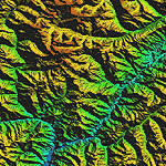
Highly detailed terrain mesh of the Tirich Mir and Pamir areas, N36-39 E71-74. The files in this package are based on Shuttle Radar (SRTM) Version 2 data but with many of the void areas, especially the most significant sections, filled with elevation data generated from topographic maps by Jonathan de Ferranti. While Jonathan's work is unrelated to flight simulation he kindly gave me permission to compile his data for use in FS. The result is a wonderful improvement in detail and accuracy over any existing mesh file, freeware or commercial, based on SRTM or DTED data alone.
Due to the large area of the Himalayas I've compiled the source data as two separate series: the "Himalayan Peaks" series covers prominent mountains and ranges in higher detail and locally overrides any existing LOD9 terrain mesh. In addition, a LOD9 "base mesh" series covering the entire Himalayas will be available for those who do not yet have an add-on terrain mesh of these beautiful mountains.
| Filename: | Himalayan_Peaks_LOD10_Mesh_Volume_8__Tirich_Mir_an.zip |
| License: | Freeware, limited distribution |
| Added: | 29th May 2010, 08:52:47 |
| Downloads: | 9,105 |
| Author: | Holger Sandmann, Jonathan de Ferranti |
| Size: | 47.94 MB |
| Category: Flight Simulator X - Scenery | |
| Mesh South America / MeSA Galapagos |
|
File Description:
This terrain mesh file is a part of a whole project covering all the Continent of South America and some islands, divided in tiles identified in a map by its column (letters) and rows (numbers). Those files were multi-LOD compiled from 90m SRTM2 source data, reprocessed with 3DEM to remove voids and spikes, providing a 76.4m (LOD9) horizontal resolution topography intended for use only in FSX updated with SP1.
Although not well documented, to improve performance, the updated FSX loads DEM files in threads and only the closer terrain (about 5 NM from the point of view) is rendered in high detail, while at far distances FSX shows up its default low resolution mesh, when there is not a third part terrain mesh compiled in all others intermediate level of details (multi-LOD).
| Filename: | Mesh_South_America__MeSA_Galapagos.zip |
| License: | Freeware |
| Added: | 10th June 2007, 21:03:25 |
| Downloads: | 1,348 |
| Author: | Hely Heck Jr. and José Lôbo |
| Size: | 1.81 MB |


© 2001-2026 AVSIM Online
All Rights Reserved
Privacy Policy |